Naracoorte Caves National Park

Last updated

Naracoorte Caves National Park
Joanna & Mount Light [1] ,  South Australia
Thylacoleo skeleton in Naracoorte Caves.jpg
Skeleton of a marsupial lion ( Thylacoleo carnifex ) in the Victoria Fossil Cave
Australia South Australia relief location map.png
Red pog.svg
Naracoorte Caves National Park
Nearest town or city Naracoorte
Coordinates 37°2′10″S140°47′51.5″E / 37.03611°S 140.797639°E / -37.03611; 140.797639
EstablishedConservation Park 27 April 1972 (1972-04-27)
National Park 18 January 2001 (2001-01-18) [3] [4]
Area6.60 km2 (2.5 sq mi) [5]
Visitation78,000 (in 1999-2000) [6]
Managing authorities Department of Environment and Water
Website Naracoorte Caves National Park
Footnotes
Naracoorte Caves National Park 1.jpg
Part ofAustralian Fossil Mammal Sites (Riversleigh/Naracoorte)
Criteria Natural: viii, ix
Reference 698-002
Inscription1994 (18th Session)
Area300 ha
See also Protected areas of South Australia

Naracoorte Caves National Park is a national park near Naracoorte in the Limestone Coast tourism region in the south-east of South Australia (Australia). It was officially recognised in 1994 for its extensive fossil record when the site was inscribed on the World Heritage List, along with Riversleigh. The park preserves 6 km2 of remnant vegetation, with 26 caves contained within the 3.05 km2 World Heritage Area. [7] Out of the 28 known caves in the park, only four are open to the public. Other caves are kept away from the public eye as they are important for scientific research and also for the protection of the caves and their contents. Many of the caves contain spectacular stalactites and stalagmites. [8]

Contents

History

European discovery

The caves, which are located within the boundaries of what is now the national park, were first encountered in 1845 with the discovery of Blanche Cave. [6]

Naracoorte Forest Reserve

In 1885, the Department of Woods and Forests appointed a caretaker due to "the popularity of the caves and their vulnerability to vandalism". [6]

National Pleasure Resort

In 1916, the control of the portion of the forest reserve which contained many of the caves and which consisted of about 20 hectares (50 acres) of land was transferred from the Department of Woods and Forests to the Immigration, Publicity and Tourist Bureau who would manage it as a national pleasure resort under the National Pleasure Resort Act 1914 until 1972. The change of control was gazetted on 1 March 1917. [9] [10] [3] The national pleasure resort's development into "an important regional tourist destination was greatly assisted by the discovery in 1969 in Victoria Cave of the largest known Australian Pleistocene vertebrate fossil cave deposit". [6]

Conservation Park

On 27 April 1972, it was renamed as the Naracoorte Caves Conservation Park upon the proclamation of the National Parks and Wildlife Act 1972 which repealed the former act along with other statutes concerned with conservation. [3] In 1982, the conservation park was listed on the now-defunct Register of the National Estate. [11]

World heritage listing

On 17 December 1994, part of the conservation park, being an area of 300 hectares (740 acres) was "inscribed on the World Heritage List" along with the Riversleigh fossil site in Queensland as the Australian Fossil Mammal Sites (Riversleigh/Naracoorte). [12]

National Park

On 18 January 2001, the Naracoorte Caves Conservation Park was abolished and the land that it occupied was reconstituted as a national park because it was considered to be "of national significance by reason of the natural features of the land" and was assigned the name, Naracoorte Caves National Park. [4]

National heritage listing

On 21 May 2007 The Australian Fossil Mammal Sites was one of 15 World Heritage places to be added to the Australian National Heritage List. [13]

State heritage listing

On 17 May 2017, the extent of the national park was listed as a state heritage place on the South Australian Heritage Register with the name of the Naracoorte Caves Complex. [14]

Visitor attraction

The park is a visitor destination in itself, with a camping ground and caravan park, dormitory accommodation for groups, picnic grounds and a licensed cafe. The range of visitor activities is extensive. Show cave tours are guided by professional interpreters through highly decorated caves with some tours visiting amazing fossil deposits. Modern technology has been utilised to show visitors the normally inaccessible interior of Bat Cave, where thousands of southern bent-wing bats breed each year. Other opportunities include adventure caving, a selection of specialty tours and special events. The Wonambi Fossil Centre, the park's visitor centre, features displays of fossils and bones found in the caves and dioramas of extinct animals.

Structure

The limestone of the area was formed from coral and marine creatures 200 million years ago and again 20 million years ago when the land was below sea level. Ground water since then has dissolved and eroded some of the limestone, creating the caves. The caves, such as the Victoria Fossil Cave and Blanche Cave, are often not far below ground, and holes open up creating traps for the unwary. This is the source of the remarkable collection of fossils. Mammals and other land creatures have fallen into open caves and been unable to escape. The fossil record has been preserved in strata formed from eroded topsoil washed and blown in. In some places, the fossil-bearing silt is up to 20 metres thick. Some of these areas are being preserved for future research when better methods of dating and reconstructing fossil records may have been found. These fossil traps are especially significant for tracing Australian megafauna.

The latest research [15] pushes back the date of the caves' formation to at least 1.34 million years ago.

See also

Related Research Articles

<span class="mw-page-title-main">Protected areas of South Australia</span> Areas protected by legislation in South Australia

Protected areas of South Australia consists of protected areas located within South Australia and its immediate onshore waters and which are managed by South Australian Government agencies. As of March 2018, South Australia contains 359 separate protected areas declared under the National Parks and Wildlife Act 1972, the Crown Land Management Act 2009 and the Wilderness Protection Act 1992 which have a total land area of 211,387.48 km2 (81,617.16 sq mi) or 21.5% of the state's area.

<span class="mw-page-title-main">Limestone Coast</span> Region in South Australia

The Limestone Coast is a name used since the early twenty-first century for a South Australian government region located in the south east of South Australia which immediately adjoins the continental coastline and the Victorian border. The name is also used for a tourist region and a wine zone both located in the same part of South Australia.

<span class="mw-page-title-main">Riversleigh World Heritage Area</span> UNESCO World Heritage Site in Queensland, Australia

Riversleigh World Heritage Area is Australia's most famous fossil location, recognised for the series of well preserved fossils deposited from the Late Oligocene to more recent geological periods. The fossiliferous limestone system is located near the Gregory River in the north-west of Queensland, an environment that was once a very wet rainforest that became more arid as the Gondwanan land masses separated and the Australian continent moved north. The approximately 100 square kilometres (39 sq mi) area has fossil remains of ancient mammals, birds, and reptiles of the Oligocene and Miocene ages, many of which were discovered and are only known from the Riversleigh area; the species that have occurred there are known as the Riversleigh fauna.

Hacks Lagoon Conservation Park is a protected area in the Australian state of South Australia located in the locality of Bool Lagoon about 24 kilometres south of the municipal seat of Naracoorte.

<span class="mw-page-title-main">Bool Lagoon Game Reserve</span> Protected area in South Australia

Bool Lagoon Game Reserve is a protected area located in the Limestone Coast region of South Australia, about 24 kilometres south of the town of Naracoorte.

Fairview Conservation Park is a protected area in the Australian state of South Australia located in the gazetted locality of Woolumbool about 17 kilometres (11 mi) north of Lucindale in the state's Limestone Coast region.

<span class="mw-page-title-main">Horsnell Gully Conservation Park</span> Protected area in South Australia

Horsnell Gully Conservation Park is a protected area in the Australian state of South Australia in the locality of Horsnell Gully located about 9 kilometres (5.6 mi) east of the state capital of Adelaide and about 2.3 kilometres (1.4 mi) southwest of Norton Summit.

Australian Fossil Mammal Sites is a combined listing in the UNESCO World Heritage Sites for two places in Australia known for their extensive fossil remains.

<span class="mw-page-title-main">Blanche Cave</span> Cave in South Australia

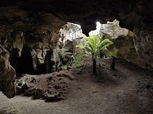
Blanche Cave, previously known as "The Big Cave", "The Old Cave" and "Mosquito Plains Cave", is one of 26 caves to be found in the Naracoorte Caves National Park, a World Heritage listed site. Blanche Cave was the first of the caves to be discovered in the Naracoorte area, having been found by European settlers in 1845, and can be accessed by the public through guided tours of the site. The cave contains a number of features, including, at one time, the mummified remains of an indigenous man – remains that were stolen twice in 1861 and never returned. The location has been the site for a number of events, such as, in the early days, annual New Years parties and, much more recently, it was featured as part of the Olympic torch relay for the 2000 Summer Olympics in Sydney. Blanche Cave, along with the nearby Victoria Fossil Cave, was added to the South Australian Heritage Register in 1984.

Ferguson Conservation Park, formerly Ferguson National Pleasure Resort and Ferguson Recreation Park, is a protected area in the Australian state of South Australia located within the Adelaide metropolitan area in the suburb of Stonyfell, about 6.5 kilometres east of the Adelaide city centre.

Nilpena Ediacara National Park, which includes the former Ediacara Conservation Park, is a protected area located in the northern Flinders Ranges, in the state of South Australia. It is located about around 551 km (342 mi) north of the city of Adelaide, around 30 kilometres south-west of the town of Leigh Creek in the state's Far North.

Mullinger Swamp Conservation Park is a protected area in the Australian state of South Australia located in the state's south-east in the gazetted locality of Kybybolite on the border with the state of Victoria about 25 kilometres (16 mi) north-east of Naracoorte.

Grass Tree Conservation Park is a protected area in the Australian state of South Australia located in the state's Limestone Coast in the gazetted locality of Cadgee about 17 kilometres (11 mi) north of the town centre in Naracoorte.

Big Heath Conservation Park is a protected area in the Australian state of South Australia located in the gazetted locality of Spence about 20 kilometres (12 mi) south-west of Naracoorte in the state's Limestone Coast region.

Mary Seymour Conservation Park is a protected area in the Australian state of South Australia located in the south-east of the state in the gazetted locality of Bool Lagoon about 25 kilometres (16 mi) south-west of the town centre of Naracoorte.

<span class="mw-page-title-main">Joanna, South Australia</span> Town in South Australia

Joanna is a locality in the Australian state of South Australia located in the state's south-east within the state’s Limestone Coast region about 325 kilometres south east of the state capital of Adelaide, about 19.5 kilometres south-east of the municipal seat of Naracoorte.

<span class="mw-page-title-main">Dingley Dell Conservation Park</span> Protected area in South Australia

Dingley Dell Conservation Park is a protected area in the Australian state of South Australia located in the state's south east in the gazetted locality of Port MacDonnell about 4 kilometres (2.5 mi) north-west of the town centre of Port MacDonnell and about 26 kilometres (16 mi) south of the city centre in Mount Gambier.

Glen Roy Conservation Park is a protected area located in the Australian state of South Australia in the locality of Glenroy about 323 kilometres (201 mi) south-east of the state capital of Adelaide and about 25 kilometres (16 mi) north of the town of Penola.

The Knoll Conservation Park is a protected area located in the Australian state of South Australia in the suburb of Crafers West in the Adelaide Hills state government region about 12 kilometres (7.5 mi) south-east of the state capital of Adelaide and about 1.5 kilometres (0.93 mi) west of the town centre in Stirling.

Jip Jip Conservation Park is a protected area in the Australian state of South Australia located in the state’s south-east in the gazetted locality of Marcollat about 223 kilometres (139 mi) south-east of the state capital of Adelaide and about 50 kilometres (31 mi) north-east of the municipal seat of Kingston SE.

References

  1. "Search results for "Naracoorte caves National Park" with the following datasets selected – "NPW and Conservation Properties", "Suburbs and Localities", "Local Government Areas", "SA Government Regions" and "Gazetteer"". Location SA Map Viewer. Government of South Australia. Retrieved 19 October 2019.
  2. "Terrestrial Protected Areas of South Australia (refer 'DETAIL' tab )". CAPAD 2016. Australian Government, Department of the Environment (DoE). 2016. Retrieved 21 February 2018.
  3. 1 2 3 "No. 56 of 1972 (National Parks and Wildlife Act, 1972)". The South Australian Government Gazette. Government of South Australia: 660 & 702. 27 April 1972. Retrieved 26 February 2018.
  4. 1 2 Brindal, Mark (18 January 2001). "NATIONAL PARKS AND WILDLIFE ACT 1972 SECTIONS 29(3) AND 28(1): ABOLITION OF NARACOORTE CAVES CONSERVATION PARK AND CONSTITUTION OF NARACOORTE CAVES NATIONAL PARK" (PDF). South Australian Government Gazette. South Australian Government. p. 70. Archived (PDF) from the original on 26 February 2018. Retrieved 26 February 2018.
  5. "Protected Areas Information System - reserve list (as of 25 November 2014)" (PDF). Department of Environment Water and Natural Resources. Archived (PDF) from the original on 2 July 2015. Retrieved 8 January 2015.
  6. 1 2 3 4 Naracoorte Caves National Park management plan, South East, South Australia (PDF), South East Region, National Parks and Wildlife SA, Department for Environment and Heritage, 2001, p. 15, ISBN   978-0-7308-5846-1, archived (PDF) from the original on 26 February 2018
  7. "Australian Fossil Mammal Sites (Riversleigh / Naracoorte)". UNESCO World Heritage Centre. Retrieved 17 May 2015.
  8. "About Naracoorte Caves". National Parks South Australia.
  9. STYLES, A. W. (1 March 1917). "GRANT OF NARACOORTE CAVES AS A PUBLIC PLEASURE RESORT, &c" (PDF). The South Australian Government Gazette. South Australian Government. p. 368. Archived (PDF) from the original on 23 August 2021. Retrieved 30 March 2018.
  10. "THE NARRACOORTE CAVES". The Border Watch . Vol. LV, no. 5463. South Australia. 22 July 1916. p. 4. Retrieved 26 February 2018 via National Library of Australia.
  11. "Naracoorte Caves Conservation Park (Place ID 8013)". Australian Heritage Database . Australian Government.
  12. "Australian Fossil Mammal Sites (Riversleigh/Naracoorte), Naracoorte, SA, Australia (Place ID 105089)". Australian Heritage Database . Australian Government.
  13. "Australian Fossil Mammal Sites (Naracoorte), Naracoorte, SA, Australia (Place ID 105692)". Australian Heritage Database . Australian Government. 21 May 2007. Retrieved 21 March 2018.
  14. "Naracoorte Caves Complex (designated place of geological, palaeontological and speleological significance)". Heritage Places Database. South Australian Government. 17 May 2017. Retrieved 26 February 2018.
  15. World Heritage-listed Naracoorte Caves 500,000 years older than previously thought, research reveals, Jack D Evans, ABC News Online, 2022-09-29

Further reading