The Great Victoria Desert is a sparsely populated desert ecoregion and interim Australian bioregion in Western Australia and South Australia.

Protected areas of Australia include Commonwealth and off-shore protected areas managed by the Australian government, as well as protected areas within each of the six states of Australia and two self-governing territories, the Australian Capital Territory and the Northern Territory, which are managed by the eight state and territory governments.

Protected areas of South Australia consists of protected areas located within South Australia and its immediate onshore waters and which are managed by South Australian Government agencies. As of March 2018, South Australia contains 359 separate protected areas declared under the National Parks and Wildlife Act 1972, the Crown Land Management Act 2009 and the Wilderness Protection Act 1992 which have a total land area of 211,387.48 km2 (81,617.16 sq mi) or 21.5% of the state's area.

Anne Beadell Highway is an outback unsealed track linking Coober Pedy, South Australia, and Laverton, Western Australia, a total distance of 1,325 km (823 mi). The track was surveyed and built by Len Beadell, Australian surveyor, who named it after his wife. The track passes through remote arid deserts and scrub territory of South Australia and Western Australia, which often have summer temperatures approaching 50 °C (122 °F). Sand dunes predominate for most of the track.

The Pila Nguru, often referred to in English as the Spinifex people, are an Aboriginal Australian people of Western Australia, whose lands extend to the border with South Australia and to the north of the Nullarbor Plain. The centre of their homeland is in the Great Victoria Desert, at Tjuntjunjarra, some 700 kilometres (430 mi) east of Kalgoorlie, perhaps the remotest community in Australia. Their country is sometimes referred to as Spinifex country. The Pila Nguru were the last Australian people to have dropped the complete trappings of their traditional lifestyle.
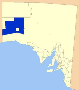
Oak Valley is the only community of Maralinga Tjarutja Aboriginal Council (AC) Local Government Area (LGA), South Australia. The population fluctuates, but a 2016 survey reported around 128 people, mostly Aboriginal. It is approximately 128 kilometres (80 mi) NNW of the original Maralinga township, and lies at the southern edge of the Great Victoria Desert. It is named for the desert oaks that populate the vicinity of the community.

The Maralinga Tjarutja, or Maralinga Tjarutja Council, is the corporation representing the traditional Anangu owners of the remote western areas of South Australia known as the Maralinga Tjarutja lands. The council was established by the Maralinga Tjarutja Land Rights Act 1984. The area is one of the four regions of South Australia classified as an Aboriginal Council (AC) and not incorporated within a local government area.
Nullarbor Regional Reserve is a protected area in South Australia located about 300 kilometres west of Ceduna.

Yalata is an Aboriginal community located 200 kilometres (120 mi) west of Ceduna and 140 km (87 mi) south of Ooldea on the edge of the Nullarbor Plain in South Australia. It lies on the traditional lands of the Wirangu people, but the settlement began as Yalata Mission in the early 1950s when Pila Nguru people were moved from Ooldea Mission when that closed, after previously being moved from their land in the Great Victoria Desert owing to nuclear testing by the British Government.

The Riverland Biosphere Reserve, formerly the Bookmark Biosphere Reserve, is a 9,000 square kilometres area of land in eastern South Australia, adjoining the states of New South Wales and Victoria. It is one of 14 biosphere reserves in Australia and is part of the World Network of Biosphere Reserves, being officially recognized and listed by UNESCO in 1977.

An Indigenous Protected Area (IPA) is a class of protected area used in Australia; each is formed by voluntary agreement with Indigenous Australians, and declared by Aboriginal Australians and Torres Strait Islander representative organisations. Each is formally recognised by the Australian Government as being part of its National Reserve System. The areas may comprise land and sea, and are managed by Indigenous groups for the conservation of biodiversity. Managing IPAs also helps to protect the cultural values of their country for future generations, and has benefits for Indigenous health, education, economic and social cohesion.
Danggali Conservation Park is a protected area located about 65 kilometres north of Renmark in South Australia. The conservation park was proclaimed under the National Parks and Wildlife Act 1972 in 1976. In 2009, a portion of the conservation park was excised to create the Danggali Wilderness Protection Area. The conservation park is classified as an IUCN Category Ia protected area.
Goose Island Conservation Park is a protected area in the Australian state of South Australia, located on Goose Island and other islets in the vicinity of Wardang Island in Spencer Gulf. The constituent islands are located within 5 kilometres to 12 kilometres in the sector between west and north west of Port Victoria.

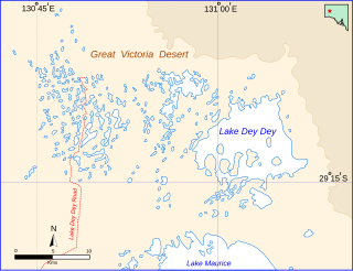
Lake Dey Dey is one of many ephemeral salt lakes located in the eastern end of the Great Victoria Desert, in the Far North region of South Australia.
Baird Bay Islands Conservation Park is a protected area in the Australian state of South Australia associated with two islands located in Baird Bay on the west coast of Eyre Peninsula respectively about 32 kilometres and 45 kilometres west south-west of Streaky Bay.
Danggali Wilderness Protection Area is a protected area located about 70 kilometres north of Renmark in South Australia. The wilderness protection area was proclaimed under the Wilderness Protection Act 1992 on 28 May 2009 on land excised from the Danggali Conservation Park. It is classified as an IUCN Category Ib protected area.
Moorook Game Reserve is a protected area in the Australian state of South Australia covering the floodplain on the south side of the River Murray in the localities of Kingston-on-Murray and Moorook immediately south of the section of the Sturt Highway that passes between the towns of Kingston-on-Murray in the west and Cobdogla in the east. It is located about 180 kilometres east north-east of the state capital of Adelaide.
Taylorville Station is a protected area located in the east of the Australian state of South Australia about 35 kilometres north west of the town of Renmark and about 250 kilometres east of the state capital of Adelaide. It is a protected area which is under the control of the Australian government rather than the Government of South Australia and which is managed by a private organisation under contract. Taylorville Station is part of an area whose habitat has been listed as "critical" for the survival of the bird species, black-eared miner. It is also part of a larger reserve system known as the Riverland Biosphere Reserve.
Tallaringa Conservation Park is a protected area located in the west of the Australian state of South Australia about 615 kilometres north west of the city of Port Augusta and about 90 kilometres west of the town of Coober Pedy. The conservation park was proclaimed under the National Parks and Wildlife Act 1972 in 1991.
Barkindji Biosphere Reserve is a biosphere reserve located in the Australian states of New South Wales and Victoria on land adjacent to the Murray River and within 80 kilometres (50 mi) of the city of Mildura.


