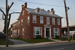
Kenton is a town in Kent County, Delaware, United States. It is part of the Dover metropolitan statistical area. The population was 215 in 2020.

Newark is a small city in New Castle County, Delaware, United States. It is located 12 miles (19 km) west-southwest of Wilmington. According to the 2010 Census, the population of the city is 31,454. Newark is home to the University of Delaware. The city constitutes part of the Delaware Valley.

Newport is a town in New Castle County, Delaware, United States. It is on the Christina River. It is best known for being the home of colonial inventor Oliver Evans. The population was 1,055 at the 2010 census. Four limited access highways, I-95, I-295, I-495, and Delaware Route 141 intersect within one mile (1.6 km) of the town.

Bridgeville is a town in Sussex County, Delaware, United States. According to the 2010 census, the population is 2,048, an increase of 42.6% from the previous decade. It is part of the Salisbury, Maryland-Delaware Metropolitan Statistical Area.

Ridgewood is a village in Bergen County, in the U.S. state of New Jersey. Ridgewood is a suburban bedroom community of New York City, located approximately 20 miles (32 km) northwest of Midtown Manhattan. As of the 2020 United States census, the village's population was 25,979, an increase of 1,021 (+4.1%) from the 2010 census count of 24,958, which in turn reflected an increase of 22 (+0.1%) from 24,936 in the 2000 census.

The Delaware Valley, sometimes referred to as Greater Philadelphia or the Philadelphia metropolitan area, is a metropolitan region in the Northeast on the East Coast of the United States that contains Philadelphia and spans four U.S. states: southeastern Pennsylvania, southern New Jersey, northern Delaware, and the northern Eastern Shore of Maryland. According to the 2020 census, the core metropolitan statistical area of the Delaware Valley had a total population of 6.288 million residents, making it the nation's 7th-largest, the continent's 8th-largest, and the world's 35th largest metropolitan areas. While the combined statistical area of the Delaware Valley contains a total population of 7.366 million.

Wallingford is an unincorporated community in Nether Providence Township, Delaware County, Pennsylvania, United States. Founded in 1687, it is named for Wallingford, England. In 2007, Wallingford was named by Money Magazine as the ninth best place to live in the United States; two other towns in the area made the top 15. Most locations in Nether Providence use Wallingford's ZIP code.

Ridgewood is a neighborhood in the New York City borough of Queens. It borders the Queens neighborhoods of Maspeth to the north, Middle Village to the east, and Glendale to the southeast, as well as the Brooklyn neighborhoods of Bushwick to the southwest and East Williamsburg to the west. Historically, the neighborhood straddled the Queens-Brooklyn boundary.
Centerville is an unincorporated community in New Castle County, Delaware, United States. Centerville is now known primarily for being the location of Du Pont family estates, as well as several other wealthy business families from nearby Wilmington, and the home of Governor Jack Markell.

Glen Rock is one of two railroad stations operated by New Jersey Transit in the borough of Glen Rock, Bergen County, New Jersey, United States. Located on the Main Line, the station is signed as Glen Rock–Main Line to differentiate it from the Glen Rock–Boro Hall station, which lies two blocks east on Rock Road on the Bergen County Line.

Highland Park is a park located in Brooklyn, New York City, on the border with Queens. Established in 1901, Highland Park borders Cypress Hills, Brooklyn—part of the East New York neighborhood—to its south, and it abuts Glendale and Ridgewood, Queens, to its north.

Belle Mead station is a train station along the CSX Trenton Subdivision and former New Jersey Transit West Trenton Line in the Belle Mead section of Montgomery Township, in Somerset County, New Jersey, United States.

Hopewell station is located in Hopewell, Mercer County, New Jersey, United States. The station was built in 1876. The head house has been on the state and federal registers of historic places since 1984 and was originally listed as part of the Operating Passenger Railroad Stations Thematic Resource. New Jersey Transit has proposed reopening the station to railroad service as part of the West Trenton Line.
Reliance is an unincorporated community located on the border of the U.S. states of Maryland and Delaware. The Maryland side of the community has portions in Caroline and Dorchester counties, while the Delaware side is located within Sussex County. Reliance is along Delaware Route 20 and Maryland Route 392 at the junction with Maryland Route 577, west of Seaford. It was previously known as Johnson's Crossroads.

State Road is an unincorporated area in New Castle County, Delaware, United States. State Road is located at the intersection of U.S. Route 13 and U.S. Route 40, southwest of New Castle.
Ridgewood Bus Terminal is a New Jersey Transit transportation hub located in downtown Ridgewood, New Jersey, United States. The terminal is located on the northwest corner of the intersection of Oak Street and Dayton Street at Van Neste Square, approximately 820 feet (250 m) ESE of NJTransit's Ridgewood train station.
Quakertown is an unincorporated community in Sussex County, Delaware, United States. Quakertown is located on U.S. Route 9 Business, southwest of Lewes.
The Pennsylvania State Game Lands Number 324 are Pennsylvania State Game Lands in Berks County in Pennsylvania in the United States providing hunting, bird watching, and other activities.
Ridgewood is a census-designated place (CDP) in Will County, Illinois, United States. It is northwest of the center of the county, bordered to the east and west by the city of Joliet. U.S. Route 30 runs along the southern edge of the CDP, leading west 2 miles (3 km) to the center of Joliet and east 3 miles (5 km) to Interstate 80.


