Peru, Kansas

Last updated

Peru, Kansas
Chautauqua County Kansas Incorporated and Unincorporated areas Peru Highlighted.svg
Location within Chautauqua County and Kansas
Map of Chautauqua Co, Ks, USA.png
Coordinates: 37°04′49″N96°05′46″W / 37.08028°N 96.09611°W / 37.08028; -96.09611 [1]
Country United States
State Kansas
County Chautauqua
Founded1870
Incorporated 1904
Named for Peru, Illinois
Area
[2]
  Total0.32 sq mi (0.84 km2)
  Land0.32 sq mi (0.84 km2)
  Water0.00 sq mi (0.00 km2)
Elevation
[1]
804 ft (245 m)
Population
 (2020) [3]
  Total101
  Density320/sq mi (120/km2)
Time zone UTC-6 (CST)
  Summer (DST) UTC-5 (CDT)
ZIP code
67360
Area code 620
FIPS code 20-55525
GNIS ID 2396190 [1]

Peru is a city in Chautauqua County, Kansas, United States. [1] As of the 2020 census, the population of the city was 101. [3]

Contents

History

Peru was founded in 1870. [4] It was named by E. R. Cutler, president of the town company, for his hometown of Peru, Illinois. [5] [6]

Geography

According to the United States Census Bureau, the city has a total area of 0.32 square miles (0.83 km2), all of it land. [7]

Demographics

Historical population
CensusPop.Note
1880 135
1910 575
1920 570−0.9%
1930 62810.2%
1940 487−22.5%
1950 368−24.4%
1960 340−7.6%
1970 289−15.0%
1980 286−1.0%
1990 206−28.0%
2000 183−11.2%
2010 139−24.0%
2020 101−27.3%
U.S. Decennial Census

2020 census

The 2020 United States census counted 101 people, 39 households, and 24 families in Peru. [8] [9] The population density was 311.7 per square mile (120.4/km2). There were 75 housing units at an average density of 231.5 per square mile (89.4/km2). [9] [10] The racial makeup was 88.12% (89) white or European American (87.13% non-Hispanic white), 0.0% (0) black or African-American, 0.99% (1) Native American or Alaska Native, 0.0% (0) Asian, 0.0% (0) Pacific Islander or Native Hawaiian, 0.99% (1) from other races, and 9.9% (10) from two or more races. [11] Hispanic or Latino of any race was 3.96% (4) of the population. [12]

Of the 39 households, 20.5% had children under the age of 18; 51.3% were married couples living together; 7.7% had a female householder with no spouse or partner present. 35.9% of households consisted of individuals and 5.1% had someone living alone who was 65 years of age or older. [9] The average household size was 1.9 and the average family size was 2.6. [13] The percent of those with a bachelor’s degree or higher was estimated to be 14.9% of the population. [14]

17.8% of the population was under the age of 18, 6.9% from 18 to 24, 20.8% from 25 to 44, 33.7% from 45 to 64, and 20.8% who were 65 years of age or older. The median age was 52.5 years. For every 100 females, there were 77.2 males. [9] For every 100 females ages 18 and older, there were 76.6 males. [9]

The 2016-2020 5-year American Community Survey estimates show that the median household income was $31,731 (with a margin of error of +/- $11,776) and the median family income was $31,827 (+/- $14,782). [15] Males had a median income of $30,729 (+/- $21,018) versus $27,750 (+/- $16,431) for females. The median income for those above 16 years old was $29,500 (+/- $13,049). [16] Approximately, 4.7% of families and 12.9% of the population were below the poverty line, including 12.5% of those under the age of 18 and 15.9% of those ages 65 or over. [17] [18]

2010 census

As of the census [19] of 2010, there were 139 people, 67 households, and 36 families residing in the city. The population density was 434.4 inhabitants per square mile (167.7/km2). There were 99 housing units at an average density of 309.4 per square mile (119.5/km2). The racial makeup of the city was 82.0% White, 8.6% Native American, 0.7% from other races, and 8.6% from two or more races. Hispanic or Latino of any race were 3.6% of the population.

There were 67 households, of which 19.4% had children under the age of 18 living with them, 47.8% were married couples living together, 3.0% had a female householder with no husband present, 3.0% had a male householder with no wife present, and 46.3% were non-families. 43.3% of all households were made up of individuals, and 6% had someone living alone who was 65 years of age or older. The average household size was 2.07 and the average family size was 2.81.

The median age in the city was 49.3 years. 16.5% of residents were under the age of 18; 11.6% were between the ages of 18 and 24; 14.4% were from 25 to 44; 35.3% were from 45 to 64; and 22.3% were 65 years of age or older. The gender makeup of the city was 54.7% male and 45.3% female.

2000 census

As of the census [20] of 2000, there were 183 people, 87 households, and 50 families residing in the city. The population density was 485.3 inhabitants per square mile (187.4/km2). There were 101 housing units at an average density of 267.9 per square mile (103.4/km2). The racial makeup of the city was 92.35% White, 1.64% African American, 4.37% Native American, and 1.64% from two or more races.

There were 87 households, out of which 23.0% had children under the age of 18 living with them, 39.1% were married couples living together, 9.2% had a female householder with no husband present, and 42.5% were non-families. 40.2% of all households were made up of individuals, and 21.8% had someone living alone who was 65 years of age or older. The average household size was 2.10 and the average family size was 2.78.

In the city, the population was spread out, with 23.0% under the age of 18, 4.9% from 18 to 24, 24.6% from 25 to 44, 24.6% from 45 to 64, and 23.0% who were 65 years of age or older. The median age was 42 years. For every 100 females, there were 90.6 males. For every 100 females age 18 and over, there were 101.4 males.

The median income for a household in the city was $25,208, and the median income for a family was $31,875. Males had a median income of $15,625 versus $12,143 for females. The per capita income for the city was $13,810. About 6.4% of families and 11.9% of the population were below the poverty line, including 13.3% of those under the age of eighteen and 8.3% of those 65 or over.

Education

Peru is served by Chautauqua County USD 286 public school district, and its Sedan Jr/Sr High School is located in Sedan. [21]

Peru High School was closed through school unification. The Peru High School mascot was Trojans. [22]

Transportation

Highway U.S. Route 166 runs through Peru.

Notable people

Related Research Articles

<span class="mw-page-title-main">Moran, Kansas</span> City in Allen County, Kansas

Moran is a city in Allen County, Kansas, United States. As of the 2020 census, the population of the city was 466.

<span class="mw-page-title-main">Morganville, Kansas</span> City in Clay County, Kansas

Morganville is a city in Clay County, Kansas, United States. As of the 2020 census, the population of the city was 180.

<span class="mw-page-title-main">Hepler, Kansas</span> City in Crawford County, Kansas

Hepler is a city in Crawford County, Kansas, United States. As of the 2020 census, the population of the city was 90.

<span class="mw-page-title-main">McCune, Kansas</span> City in Crawford County, Kansas

McCune is a city in Crawford County, Kansas, United States. As of the 2020 census, the population of the city was 370.

<span class="mw-page-title-main">Mulberry, Kansas</span> City in Crawford County, Kansas

Mulberry is a city in Crawford County, Kansas, United States. As of the 2020 census, the population of the city was 409.

<span class="mw-page-title-main">Jennings, Kansas</span> City in Decatur County, Kansas

Jennings is a city in Decatur County, Kansas, United States. As of the 2020 census, the population of the city was 81.

<span class="mw-page-title-main">Norcatur, Kansas</span> City in Decatur County, Kansas

Norcatur is a city in Decatur County, Kansas, United States. As of the 2020 census, the population of the city was 159.

<span class="mw-page-title-main">Gove City, Kansas</span> City in Gove County, Kansas

Gove City, more commonly known as Gove, is a city in and the county seat of Gove County, Kansas, United States. As of the 2020 census, the population of the city was 80.

<span class="mw-page-title-main">Fall River, Kansas</span> City in Greenwood County, Kansas

Fall River is a city in Greenwood County, Kansas, United States. As of the 2020 census, the population of the city was 131.

<span class="mw-page-title-main">Netawaka, Kansas</span> City in Jackson County, Kansas

Netawaka is a city in Jackson County, Kansas, United States. As of the 2020 census, the population of the city was 139.

<span class="mw-page-title-main">Edgerton, Kansas</span> City in Kansas, United States

Edgerton is a city in Johnson County, Kansas, United States, and part of the Kansas City metropolitan area. As of the 2020 census, the population of the city was 1,748. It is home to a large BNSF intermodal train facility named Logistics Park Kansas City.

<span class="mw-page-title-main">Mission Woods, Kansas</span> City in Kansas, United States

Mission Woods is a city in Johnson County, Kansas, United States, and part of the Kansas City Metropolitan Area. As of the 2020 census, the population of the city was 203.

<span class="mw-page-title-main">Kingman, Kansas</span> City in Kingman County, Kansas

Kingman is a city in and the county seat of Kingman County, Kansas, United States. As of the 2020 census, the population of the city was 3,105.

<span class="mw-page-title-main">Meade, Kansas</span> City in Meade County, Kansas

Meade is a city in and the county seat of Meade County, Kansas, United States. As of the 2020 census, the population of the city was 1,505.

<span class="mw-page-title-main">Ness City, Kansas</span> City in Ness County, Kansas

Ness City is a city in and the county seat of Ness County, Kansas, United States. As of the 2020 census, the population of the city was 1,329. Ness City is famous for its four-story Old Ness County Bank Building located downtown, and nicknamed Skyscraper of the Plains.

<span class="mw-page-title-main">Lyndon, Kansas</span> City in Osage County, Kansas

Lyndon is a city in, and the county seat of Osage County, Kansas, United States. As of the 2020 census, the population of the city was 1,037.

<span class="mw-page-title-main">Belleville, Kansas</span> City in Republic County, Kansas

Belleville is a city in and the county seat of Republic County, Kansas, United States. As of the 2020 census, the population of the city was 2,007.

<span class="mw-page-title-main">Munden, Kansas</span> City in Republic County, Kansas

Munden is a city in Republic County, Kansas, United States. As of the 2020 census, the population of the city was 96.

<span class="mw-page-title-main">Clearwater, Kansas</span> City in Sedgwick County, Kansas

Clearwater is a city in Sedgwick County, Kansas, United States. As of the 2020 census, the population of the city was 2,653.
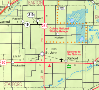
<span class="mw-page-title-main">Mayfield, Kansas</span> City in Sumner County, Kansas

Mayfield is a city in Sumner County, Kansas, United States. As of the 2020 census, the population of the city was 75.

References

  1. 1 2 3 4 U.S. Geological Survey Geographic Names Information System: Peru, Kansas
  2. "2019 U.S. Gazetteer Files". United States Census Bureau. Retrieved July 24, 2020.
  3. 1 2 "Profile of Peru, Kansas in 2020". United States Census Bureau. Archived from the original on May 23, 2022. Retrieved May 23, 2022.
  4. Kansas State Historical Society (1916). Biennial Report of the Board of Directors of the Kansas State Historical Society. Kansas State Printing Plant. pp.  155.
  5. Rydjord, John (1972). Kansas Place-Names. University of Oklahoma Press, Norman, Oklahoma. p. 98 & 280. ISBN   0-8061-0994-7.
  6. "Profile for Peru, Kansas". ePodunk . Retrieved June 6, 2014.
  7. "US Gazetteer files 2010". United States Census Bureau. Archived from the original on January 25, 2012. Retrieved July 6, 2012.
  8. "US Census Bureau, Table P16: HOUSEHOLD TYPE". data.census.gov. Retrieved January 3, 2024.
  9. 1 2 3 4 5 "US Census Bureau, Table DP1: PROFILE OF GENERAL POPULATION AND HOUSING CHARACTERISTICS". data.census.gov. Retrieved January 3, 2024.
  10. Bureau, US Census. "Gazetteer Files". Census.gov. Retrieved December 30, 2023.
  11. "US Census Bureau, Table P1: RACE". data.census.gov. Retrieved January 3, 2024.
  12. "US Census Bureau, Table P2: HISPANIC OR LATINO, AND NOT HISPANIC OR LATINO BY RACE". data.census.gov. Retrieved January 3, 2024.
  13. "US Census Bureau, Table S1101: HOUSEHOLDS AND FAMILIES". data.census.gov. Retrieved January 3, 2024.
  14. "US Census Bureau, Table S1501: EDUCATIONAL ATTAINMENT". data.census.gov. Retrieved January 3, 2024.
  15. "US Census Bureau, Table S1903: MEDIAN INCOME IN THE PAST 12 MONTHS (IN 2020 INFLATION-ADJUSTED DOLLARS)". data.census.gov. Retrieved January 3, 2024.
  16. "US Census Bureau, Table S2001: EARNINGS IN THE PAST 12 MONTHS (IN 2020 INFLATION-ADJUSTED DOLLARS)". data.census.gov. Retrieved January 3, 2024.
  17. "US Census Bureau, Table S1701: POVERTY STATUS IN THE PAST 12 MONTHS". data.census.gov. Retrieved January 3, 2024.
  18. "US Census Bureau, Table S1702: POVERTY STATUS IN THE PAST 12 MONTHS OF FAMILIES". data.census.gov. Retrieved January 3, 2024.
  19. "U.S. Census website". United States Census Bureau . Retrieved July 6, 2012.
  20. "U.S. Census website". United States Census Bureau . Retrieved January 31, 2008.
  21. "Home Page". Chautauqua County USD 286. February 13, 2023.
  22. "Peru High School". classmates.com. Retrieved January 15, 2017.

Further reading