National Wildlife RefugeSystem is a designation for certain protected areas of the United States managed by the United States Fish and Wildlife Service. The National Wildlife Refuge System is the system of public lands and waters set aside to conserve America's fish, wildlife, and plants. Since President Theodore Roosevelt designated Florida's Pelican Island National Wildlife Refuge as the first wildlife refuge in 1903, the system has grown to over 568 national wildlife refuges and 38 wetland management districts encompassing more than 150,000,000 acres (607,028 km2).

Pelican Island National Wildlife Refuge is a United States National Wildlife Refuge (NWR), and part of the Everglades Headwaters NWR complex, located just off the western coast of Orchid Island in the Indian River Lagoon east of Sebastian, Florida. The refuge consists of a 3-acre (12,000 m2) island that includes an additional 2.5 acres (10,000 m2) of surrounding water and is located off the east coast of Florida of the Indian River Lagoon. Established by an executive order of President Theodore Roosevelt on March 14, 1903, Pelican Island was the first National wildlife refuge in the United States. It was created to protect egrets and other birds from extinction through plume hunting.

Aransas National Wildlife Refuge is a 115,324 acre (466.7 km2) protected area situated on the southwest side of San Antonio Bay along the Gulf Coast of the U.S. state of Texas. It is located in parts of Aransas, Refugio, and Calhoun counties. It is situated on the southwest side of the San Antonio Bay, formed by the mouth of the Guadalupe River. It also includes nearly the entirety of Matagorda Island, a 38-mile barrier island. The Aransas National Wildlife Refuge was established by Executive Order 7784 on 31 December 1937 by President Franklin D. Roosevelt as the Aransas Migratory Waterfowl Refuge as a refuge and breeding ground for migratory birds and other wildlife. Roosevelt issued a proclamation in 1940 changing the name to the Aransas National Wildlife Refuge.

Sabine National Wildlife Refuge is a National Wildlife Refuge of the United States located in Cameron Parish in southwestern Louisiana. It is on Louisiana State Route 27, 8 miles (13 km) south of Hackberry and 12 miles (19 km) north of Holly Beach. The western boundary of the Sabine Refuge is Sabine Lake, the inlet for Port Arthur, Texas, while the tip of the eastern end reaches Calcasieu Lake.

The Pinckney Island National Wildlife Refuge is a 4,053-acre (16 km2) National Wildlife Refuge located in Beaufort County, South Carolina between the mainland and Hilton Head Island. Named after Major General Charles Cotesworth Pinckney, it was established to provide a nature and forest preserve for aesthetic and conservation purposes.

The Key West National Wildlife Refuge is a 189,497 acre (766.867 km2) National Wildlife Refuge located in Monroe County, Florida, between Key West, Florida and the Dry Tortugas. Only 2,019 acres (8.171 km2) of land are above sea level, on several keys within the refuge. These keys are unpopulated and are also designated as Wilderness within the Florida Keys Wilderness. The refuge was established to provide a preserve and breeding ground for native birds and other wildlife as well as to provide habitat and protection for endangered and threatened fish, wildlife, plants and migratory birds.

The Lake Wales Ridge National Wildlife Refuge is part of the United States National Wildlife Refuge (NWR) System, located in four separated areas on the Lake Wales Ridge east of US 27 between Davenport and Sebring Florida. The 1,194 acre (4.8 km2) refuge was established in 1990, to protect a host of plants and animals. It is also the first to be designated primarily for the preservation of endangered plants, and is not open to the general public. It contains a high proportion of remaining Florida scrub habitat. It is administered as part of the Merritt Island National Wildlife Refuge.

The Pinellas National Wildlife Refuge is part of the United States National Wildlife Refuge (NWR) System, located offshore from mainland St. Petersburg, Florida, and only accessible by boat. The 394-acre (1.59 km2) refuge was established in 1951, to act as a breeding ground for colonial bird species. Islands within the refuge include Indian, Tarpon, Mule, and Jackass Keys, and all are within the St. Petersburg city limits.
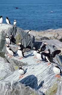
Seal Island National Wildlife Refuge is a 1-mile long (1.6 km) island off the coast of Maine, United States near Matinicus Island that is part of the Maine Coastal Islands National Wildlife Refuge. During any given summer season, over 100 species of birds are observed by researchers on the island. It is home to colonies of many types of seabirds, including Atlantic puffins, double-crested cormorants, razorbills, Leach's storm petrels, eiders, and black guillemots. Seal Island is the last refuge for the dwindling great cormorant population in the Gulf of Maine, with 35 pairs in 2018. A policy of eliminating predatory gulls preceded the recolonization of the island by a large mixed band of Arctic terns and common terns.

The Blackbeard Island National Wildlife Refuge is a 5,618 acre National Wildlife Refuge located in McIntosh county in Georgia. The refuge was established to provide a nature and forest preserve for aesthetic and conservation purposes.

Lacassine National Wildlife Refuge is located in Cameron and Evangeline Parishes in southwestern Louisiana, was established in 1937 by Executive Order No. 7780 as "a refuge and breeding ground for migratory birds and other wildlife." The refuge is nearly 35,000 acres (140 km2) in size, including 653 acres (2.64 km2) leased from the Cameron Parish School Board. The Evangeline Parish unit is called Duralde Prairie and is currently being developed. It is located north of the city of Eunice.

Trustom Pond is a closed lagoon in South Kingstown, Washington County, Rhode Island, United States. It is one of nine coastal lagoons in southern Rhode Island. It has a surface area of 800 acres (320 ha), and is the only undeveloped salt pond in the state. The pond averages 1.3 feet (0.40 m) deep, and has a salinity level of 5 parts per thousand. It is non-tidal, except when breached by storms. The water directly receives about 219,844,022 US gallons (832,200,150 L) of precipitation per year, with an estimated 796,215 US gallons (3,014,000 L) in daily groundwater flow. No streams flow into the pond, though a nearby stream "captures water that otherwise would have flowed to Trustom Pond".

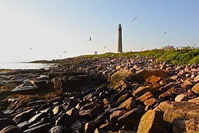
Petit Manan Light is a lighthouse on Petit Manan Island, Maine. The island is at the end of a series of ledges extending out from Petit Manan Point, between Dyer Bay and Pigeon Hill Bay, that projects into the Gulf of Maine.

Cross Island National Wildlife Refuge is a National Wildlife Refuge in the state of Maine. It is one of the five refuges that together make up the Maine Coastal Islands National Wildlife Refuge, along with Petit Manan, Franklin Island, Seal Island, and Pond Island.
Franklin Island National Wildlife Refuge is a National Wildlife Refuge on Franklin Island outside Muscongus Bay in the state of Maine. It is one of the five refuges that together make up the Maine Coastal Islands National Wildlife Refuge, along with Petit Manan, Cross Island, Seal Island, and Pond Island.

Pond Island National Wildlife Refuge is a National Wildlife Refuge in the state of Maine. It is one of the five refuges that together make up the Maine Coastal Islands National Wildlife Refuge, along with Petit Manan, Cross Island, Franklin Island, and Seal Island. Pond Island NWR is an island in the mouth of the Kennebec River adjacent to Popham Beach.
Maine Coastal Islands National Wildlife Refuge contains more than 50 offshore islands and four coastal parcels, totaling more than 8,100 acres. The complex spans more than 250 miles of Maine coastline and includes five national wildlife refuges — Petit Manan, Cross Island, Franklin Island, Seal Island, and Pond Island. The U.S. Fish and Wildlife Service manages the refuge complex as part of the National Wildlife Refuge System.
Moosehorn National Wildlife Refuge is one of the northernmost National Wildlife Refuges in the Atlantic Flyway, a migratory route that follows the eastern coast of North America. The refuge provides important feeding and nesting habitat for many bird species, including waterfowl, wading birds, shorebirds, upland game birds, songbirds, and birds of prey.
Massasoit National Wildlife Refuge was established in 1983 to conserve the federally endangered Plymouth Red-bellied Turtle, as well as other wildlife and plant species. The Refuge encompasses 195 acres (0.79 km2) in Plymouth, Massachusetts. It is made up of two parcels; the Crooked Pond parcel abuts the Myles Standish State Forest, the second largest State forest in Massachusetts, and the smaller parcel is located on the shoreline of Island Pond. Massasoit National Wildlife Refuge is located within a 3,269-acre (13.23 km2) area designated as critical habitat for the Plymouth Red-bellied Turtle.

The Sayville National Wildlife Refuge is a 127-acre (51 ha) National Wildlife Refuge (NWR) located in West Sayville, New York about two miles (3.2 km) inland from the Great South Bay. Sayville NWR is managed by the U.S. Fish and Wildlife Service as a sub-unit of Wertheim National Wildlife Refuge and part of the Long Island National Wildlife Refuge Complex. It is the only land-locked refuge in the complex.