The Fox–Wisconsin Waterway is a waterway formed by the Fox and Wisconsin Rivers. First used by European settlers in 1673 during the expedition of Marquette & Joliet, it was one of the principal routes used by travelers between the Great Lakes and the Mississippi River until the completion of the Illinois and Michigan Canal in 1848 and the arrival of railroads. The western terminus of the Fox–Wisconsin Waterway was at the Mississippi at Prairie du Chien, Wisconsin. It continued up the Wisconsin River about 116 miles (187 km) until reaching Portage, Wisconsin. There travelers would portage to the Upper Fox River, or eventually, use the Portage Canal. It continued about 160 miles (260 km) down the Fox River, following it through Lake Winnebago and continuing on the Lower Fox over 170 feet of falls to the eastern terminus of Green Bay.

The Grand Trunk Western Railroad Company was an American subsidiary of the Canadian National Railway operating in Michigan, Illinois, Indiana, and Ohio. Since a corporate restructuring in 1971, the railroad has been under CN's subsidiary holding company, the Grand Trunk Corporation. Grand Trunk Western's routes are part of CN's Michigan Division. Its primary mainline between Chicago and Port Huron, Michigan serves as a connection between railroad interchanges in Chicago and rail lines in eastern Canada and the Northeastern United States. The railroad's extensive trackage in Detroit and across southern Michigan has made it an essential link for the automotive industry as a hauler of parts and automobiles from manufacturing plants.

The Charlevoix South Pier Light Station is located on Lake Michigan at the entrance to Lake Charlevoix in Charlevoix County in the U.S. state of Michigan at the end of the south pier/breakwater of the channel leading to Round Lake in the city of Charlevoix.

The Port of San Francisco is a semi-independent organization that oversees the port facilities at San Francisco, California, United States. It is run by a five-member commission, appointed by the Mayor and approved by the Board of Supervisors. The Port is responsible for managing the larger waterfront area that extends from the anchorage of the Golden Gate Bridge, along the Marina district, all the way around the north and east shores of the city of San Francisco including Fisherman's Wharf and the Embarcadero, and southward to the city line just beyond Candlestick Point. In 1968 the State of California, via the California State Lands Commission for the State-operated San Francisco Port Authority, transferred its responsibilities for the Harbor of San Francisco waterfront to the City and County of San Francisco / San Francisco Harbor Commission through the Burton Act AB2649. All eligible State port authority employees had the option to become employees of the City and County of San Francisco to maintain consistent operation of the Port of San Francisco.

Grand Haven State Park is a public recreation area on the shores Lake Michigan on the south side of the mouth of the Grand River and harbor in Grand Haven, Michigan. The state park encompasses 48 acres (19 ha) consisting entirely of beach sand. It features camping and beach activities along with scenic views of the Grand Haven South Pierhead Entrance Light and Grand Haven South Pierhead Inner Light.

SS Milwaukee Clipper, also known as SS Clipper, and formerly as SS Juniata, is a retired passenger ship and automobile ferry that sailed under two configurations and traveled on all of the Great Lakes except Lake Ontario. The vessel is now docked in Muskegon, Michigan.

Jackson station is a historic Amtrak station in Jackson, Michigan, United States. It is served by three daily Wolverine trains between Chicago and Pontiac and a single daily Amtrak Thruway bus between Toledo, Detroit, Jackson, and East Lansing. The station was added to the National Register of Historic Places in 2002.
Portage Lake is a natural lake, located in Onekama Township in Manistee County, Michigan, United States. The village of Onekama, Michigan is situated at the northeastern end of the lake.
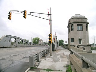
The West Jefferson Avenue–Rouge River Bridge is a bridge located where Jefferson Avenue crosses the Rouge River at the border of Detroit and River Rouge, Michigan. It is the only surviving pony truss bascule bridge in the state of Michigan. It was listed on the National Register of Historic Places in 2000.

The Ontonagon Harbor Piers Historic District is historic shipping structure located on the Ontonagon River at Lake Superior in Ontonagon, Michigan. It was listed on the National Register of Historic Places in 2001.
The Grand Marais Harbor of Refuge Inner and Outer Lights are a pair of lighthouses located on the west pier at the entry to Grand Marais Harbor of Refuge, in Grand Marais, Michigan. They were listed on the National Register of Historic Places in 2012.

The Navigation Structures at Pentwater Harbor are navigational structures located at the west end of Lowell Street in Pentwater, Michigan. They were listed on the National Register of Historic Places in 2001.

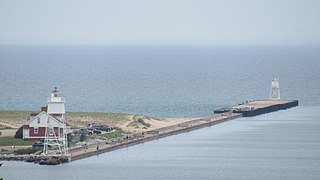
The Navigation Structures at Frankfort Harbor are a collection of breakwaters, piers, and other structures in Lake Michigan located at the foot of Second Street in Frankfort, Michigan. They were listed on the National Register of Historic Places in 1997.

The Keweenaw Waterway Lower Entrance Light, also known as the Portage Entry Light, is a lighthouse located at the south end of breakwater at mouth of the Portage River in Torch Lake Township. It was listed on the National Register of Historic Places in 2014.

The Navigation Structures at Saugatuck Harbor consist of two piers flanking the mouth of the Kalamazoo River on the shore of Lake Michigan near Saugatuck, Michigan. The structures were listed on the National Register of Historic Places in 2001.

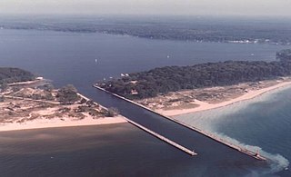
The Manistee Harbor, South Breakwater is a navigational structure located at the mouth of the Manistee River, in Manistee, Michigan. It was listed on the National Register of Historic Places in 1995. The breakwater is significant due to its construction, which represents a final stage in the United States Army Corps of Engineers's use of timber crib substructures in pier and breakwater construction.
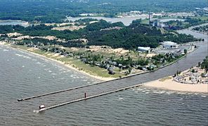
The Navigation Structures at White Lake Harbor area set of piers protecting the channel connecting Lake Michigan and White Lake, located at the end of Lau Road near Whitehall, Michigan. It was listed on the National Register of Historic Places in 2000.

The Grand Trunk Western Railroad Grand Haven Coal Tipple is a coaling tower designed to feed coal to steam locomotives located on the 300 block of North Harbor Drive in Grand Haven, Michigan. It is the tallest structure in the city. The coal tipple was listed on the National Register of Historic Places in 2016.
The City of Muskegon was a steel-hulled sidewheel package and passenger steamer, built in 1881 for service on the Great Lakes, which was wrecked early on Tuesday 28 October 1919 when it struck a pier at Muskegon, Michigan, at 0430 hrs., in a 60 mph gale, sinking in a period estimated between four and ten minutes. Nine crew and six passengers were killed. There are conflicting sources on the number on board, however. One account listed 37 passengers and a crew of 35.
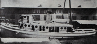
Essayons was a tugboat of the United States Army Corps of Engineers. Her mission with the Corps was to support the installation of breakwaters and piers, and the dredging of harbors on Lake Superior. She was built in 1908 and served with the Army until 1949, when she was sold to the Zenith Dredge Company. Essayons continued her support of port construction and maintenance under her new owner until the mid 1960s. In 1994 she was sold again, this time to a local businessman, who hoped to convert her into a floating Bed and Breakfast. This plan never came to fruition and she sank at her moorings in Duluth Harbor in 2009.