A caldera is a large cauldron-like hollow that forms shortly after the emptying of a magma chamber in a volcanic eruption. When large volumes of magma are erupted over a short time, structural support for the rock above the magma chamber is lost. The ground surface then collapses into the emptied or partially emptied magma chamber, leaving a large depression at the surface. Although sometimes described as a crater, the feature is actually a type of sinkhole, as it is formed through subsidence and collapse rather than an explosion or impact. Compared to the thousands of volcanic eruptions that occur each century, the formation of a caldera is a rare event, occurring only a few times per century. Only seven caldera-forming collapses are known to have occurred between 1911 and 2016. More recently, a caldera collapse occurred at Kīlauea, Hawaii in 2018.

Mount Ruapehu is an active stratovolcano at the southern end of the Taupō Volcanic Zone and North Island volcanic plateau in New Zealand. It is 23 kilometres (14 mi) northeast of Ohakune and 23 km (14 mi) southwest of the southern shore of Lake Taupō, within the Tongariro National Park. The North Island's major ski resorts and only glaciers are on its slopes.

The Ring of Fire is a region around much of the rim of the Pacific Ocean where many volcanic eruptions and earthquakes occur. The Ring of Fire is a horseshoe-shaped belt about 40,000 km (25,000 mi) long and up to about 500 km (310 mi) wide.
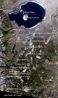
The Mono–Inyo Craters are a volcanic chain of craters, domes and lava flows in Mono County, Eastern California. The chain stretches 25 miles (40 km) from the northwest shore of Mono Lake to the south of Mammoth Mountain. The Mono Lake Volcanic Field forms the northernmost part of the chain and consists of two volcanic islands in the lake and one cinder cone volcano on its northwest shore. Most of the Mono Craters, which make up the bulk of the northern part of the Mono–Inyo chain, are phreatic volcanoes that have since been either plugged or over-topped by rhyolite domes and lava flows. The Inyo volcanic chain form much of the southern part of the chain and consist of phreatic explosion pits, and rhyolitic lava flows and domes. The southernmost part of the chain consists of fumaroles and explosion pits on Mammoth Mountain and a set of cinder cones south of the mountain; the latter are called the Red Cones.

The Lassen volcanic area presents a geological record of sedimentation and volcanic activity in and around Lassen Volcanic National Park in Northern California, U.S. The park is located in the southernmost part of the Cascade Mountain Range in the Pacific Northwest region of the United States. Pacific Oceanic tectonic plates have plunged below the North American Plate in this part of North America for hundreds of millions of years. Heat and molten rock from these subducting plates has fed scores of volcanoes in California, Oregon, Washington and British Columbia over at least the past 30 million years, including these in the Lassen volcanic areas.

Mount Mazama is a complex volcano in the state of Oregon, United States, in a segment of the Cascade Volcanic Arc and Cascade Range. Most of the mountain collapsed following a major eruption approximately 7,700 years ago. The volcano is in Klamath County, in the southern Cascades, 60 miles (97 km) north of the Oregon–California border. Its collapse formed a caldera that holds Crater Lake. The mountain is in Crater Lake National Park. Mount Mazama originally had an elevation of 12,000 feet (3,700 m), but following its climactic eruption this was reduced to 8,157 feet (2,486 m). Crater Lake is 1,943 feet (592 m) deep, the deepest freshwater body in the US and the second deepest in North America after Great Slave Lake in Canada.

The Auckland volcanic field is an area of monogenetic volcanoes covered by much of the metropolitan area of Auckland, New Zealand's largest city, located in the North Island. The approximately 53 volcanoes in the field have produced a diverse array of maars, tuff rings, scoria cones, and lava flows. With the exception of Rangitoto, no volcano has erupted more than once, but eruptions lasted for various periods ranging from a few weeks to several years. Rangitoto erupted twice; the first eruption occurred about 600 years ago, followed by a second eruption approximately 50 years later. The field is fuelled entirely by basaltic magma, unlike the explosive subduction-driven volcanism in the central North Island, such as at Mount Ruapehu and Lake Taupō. The field is currently dormant, but could become active again.
A maar is a broad, low-relief volcanic crater caused by a phreatomagmatic eruption. A maar characteristically fills with water to form a relatively shallow crater lake which may also be called a maar. The name comes from a Moselle Franconian dialect word used for the circular lakes of the Daun area of Germany.

The Anahim Volcanic Belt (AVB) is a west–east trending chain of volcanoes and related magmatic features in British Columbia, Canada. It extends from Athlone Island on the Central Coast, running eastward through the strongly uplifted and deeply dissected Coast Mountains to near the community of Nazko on the Interior Plateau. The AVB is delineated as three west-to-east segments that differ in age and structure. A wide variety of igneous rocks with differing compositions occur throughout these segments, comprising landforms such as volcanic cones, volcanic plugs, lava domes, shield volcanoes and intrusions.

Masaya is a caldera located in Masaya, Nicaragua, 20 km south of the capital Managua. It is Nicaragua's first and largest national park, and one of 78 protected areas of Nicaragua. The complex volcano is composed of a nested set of calderas and craters, the largest of which is Las Sierras shield volcano and caldera. Within this caldera lies a sub-vent, which is Masaya Volcano sensu stricto. The vent is a shield type composing of basaltic lavas and tephras and includes a summit crater. This hosts Masaya caldera, formed 2,500 years ago by an 8-km³ basaltic ignimbrite eruption. Inside this caldera a new basaltic complex has grown from eruptions mainly on a semi-circular set of vents that include the Masaya and Nindiri cones. The latter host the pit craters of Masaya, Santiago, Nindiri and San Pedro. Observations in the walls of the pit craters indicate that there have been several episodes of cone and pit crater formation.

The Pilanesberg National Park is located north of Rustenburg in the North West Province of South Africa. The park borders on the Sun City entertainment complex. It is currently administered by the North West Parks and Tourism Board.

The Magaliesberg of northern South Africa, is a modest but well-defined mountain range composed mainly of quartzites. It rises at a point south of the Pilanesberg to form a curved prominence that intersects suburban Pretoria before it peters out some 50 km (31 mi) to the east, just south of Bronkhorstspruit. The highest point of the Magaliesberg is reached at Nooitgedacht, about 1,852 metres (6,076 ft) above sea level. A cableway reaching to the top of the mountain range is located at Hartbeespoort Dam, providing sweeping views of the Magaliesberg and surrounding area.

The Northern Cordilleran Volcanic Province (NCVP), formerly known as the Stikine Volcanic Belt, is a geologic province defined by the occurrence of Miocene to Holocene volcanoes in the Pacific Northwest of North America. This belt of volcanoes extends roughly north-northwest from northwestern British Columbia and the Alaska Panhandle through Yukon to the Southeast Fairbanks Census Area of far eastern Alaska, in a corridor hundreds of kilometres wide. It is the most recently defined volcanic province in the Western Cordillera. It has formed due to extensional cracking of the North American continent—similar to other on-land extensional volcanic zones, including the Basin and Range Province and the East African Rift. Although taking its name from the Western Cordillera, this term is a geologic grouping rather than a geographic one. The southmost part of the NCVP has more, and larger, volcanoes than does the rest of the NCVP; further north it is less clearly delineated, describing a large arch that sways westward through central Yukon.
Volcanic activity is a major part of the geology of Canada and is characterized by many types of volcanic landform, including lava flows, volcanic plateaus, lava domes, cinder cones, stratovolcanoes, shield volcanoes, submarine volcanoes, calderas, diatremes, and maars, along with less common volcanic forms such as tuyas and subglacial mounds.

The Ilgachuz Range is a name given to an extinct shield volcano in British Columbia, Canada. It is not a mountain range in the normal sense, because it was formed as a single volcano that has been eroded for the past 5 million years. It lies on the Chilcotin Plateau, located some 350 kilometres (220 mi) north-northwest of Vancouver and 30 km north of Anahim Lake. The highest peak of the range is Far Mountain. The range supports a unique grassland ecosystem. This type of grassland has not been seen anywhere else in central and southern British Columbia. The climate is cool and dry; typical of higher elevations of the Interior Plateau.

The Silverthrone Caldera is a potentially active caldera complex in southwestern British Columbia, Canada, located over 350 kilometres (220 mi) northwest of the city of Vancouver and about 50 kilometres (31 mi) west of Mount Waddington in the Pacific Ranges of the Coast Mountains. The caldera is one of the largest of the few calderas in western Canada, measuring about 30 kilometres (19 mi) long (north-south) and 20 kilometres (12 mi) wide (east-west). Mount Silverthrone, an eroded lava dome on the caldera's northern flank that is 2,864 metres (9,396 ft) high, may be the highest volcano in Canada.

The Mount Edziza volcanic complex is a large and potentially active north-south trending complex volcano in Stikine Country, northwestern British Columbia, Canada, located 38 kilometres (24 mi) southeast of the small community of Telegraph Creek. It occupies the southeastern portion of the Tahltan Highland, an upland area of plateau and lower mountain ranges, lying east of the Boundary Ranges and south of the Inklin River, which is the east fork of the Taku River. As a volcanic complex, it consists of many types of volcanoes, including shield volcanoes, calderas, lava domes, stratovolcanoes, and cinder cones.
Menengai Forest is an urban forest situated within the town of Nakuru in Kenya. The Menengai Crater is within the forest. It was gazetted as a forest in the 1930s. It is surrounded by residential areas of Milimani Estate in the South, Ngachura and Bahati in the East, Solai in the North and Olo-Rongai in the West. Various Government of Kenya facilities have been hived off from the forest; these include the Kenya Broadcasting Corporation and the Nakuru G.K Prison. There is also a geothermal exploration project by the Geothermal Development Company inside the Menengai Crater floor.
The geology of Cameroon is almost universally Precambrian metamorphic and igneous basement rock, formed in the Archean as part of the Congo Craton and the Central African Mobile Zone and covered in laterite, recent sediments and soils. Some parts of the country have sequences of sedimentary rocks from the Paleozoic, Mesozoic and Cenozoic as well as volcanic rock produced by the 1600 kilometer Cameroon Volcanic Line, which includes the still-active Mount Cameroon. The country is notable for gold, diamonds and some onshore and offshore oil and gas.

