List of mountains in South Africa

Last updated

Table Mountain Table mountain and the ocean cape town.JPG
Table Mountain

List of Mountains in South Africa, Lesotho and Eswatini is a general list of mountains in South Africa, Lesotho and Eswatini with elevation. This list includes mountains in two other sovereign states, in the Stormberg-Drakensberg range, where the highest elevations are to be found in Lesotho, as well as Emlembe, the highest mountain in Eswatini, located at the border with South Africa. The highest mountain in South Africa is 3,450 metres (11,320 ft) high Mafadi, located on the border of South Africa and Lesotho.

Contents

Several of the highest peaks have snow in the Southern hemisphere winter season.

A Khulu is a peak above 3,000 m (9,800 ft) and not within 1 km (0.62 mi) of another Khulu, as defined by the Mountain Club of South Africa. [1] Seweweekspoortpiek and Du Toits Peak are among the ultra prominent peaks of Africa.

A few mountains, such as Spion Kop or Isandlwana are historically important hills, even though they are relatively not very high. Table Mountain is important because of its emblematic flatness.

List

MountainHeight (m)RangelocationRemarks
Thabana Ntlenyana 3482 Drakensberg (Maloti)LesothoHighest mountain in Southern Africa
Makheka
Thaba Putsoa 3455Drakensberg (Maloti)Lesotho
Mafadi 3451Drakensberg KwaZulu-Natal [2]
Njesuthi 3410DrakensbergKwaZulu-Natal
Champagne Castle 3377DrakensbergKwaZulu-Natal
Lithobolog 3375DrakensbergKwaZulu-Natal
kaNtuba Peak 3366DrakensbergKwaZulu-Natal
Trojan Wall 3354DrakensbergKwaZulu-Natal
kaNtuba Buttress 3344DrakensbergKwaZulu-Natal
Yodler's Peak I 3338DrakensbergKwaZulu-Natal
Yodler's Peak II 3338DrakensbergKwaZulu-Natal
Pampiring 3337DrakensbergKwaZulu-Natal
Red Wall Peak 3337DrakensbergKwaZulu-Natal
Botlolong 3333DrakensbergKwaZulu-Natal
Popple Peak 3331DrakensbergKwaZulu-Natal
Ship's Prow 3325DrakensbergKwaZulu-Natal
Sehonghong Peak 3324DrakensbergKwaZulu-Natal
Nkosozana Peak 3318DrakensbergKwaZulu-Natal
Champagne's Castle 3318DrakensbergKwaZulu-Natal
Giant's Castle 3315DrakensbergKwaZulu-Natal
Mashai 3313DrakensbergKwaZulu-Natal
Mohlesi 3310DrakensbergKwaZulu-Natal
Redi 3309DrakensbergKwaZulu-Natal
Walker's Peak 3306DrakensbergKwaZulu-Natal
Mhlwazini Peak 3305DrakensbergKwaZulu-Natal
Yodler's Ridge Peak 3301DrakensbergKwaZulu-Natal
Sanqebethu 3301DrakensbergKwaZulu-Natal
Mount Durnford 3296DrakensbergKwaZulu-Natal
Mont-aux-Sources 3282DrakensbergKwaZulu-Natal
Cleft Peak 3281DrakensbergKwaZulu-Natal
Namahadi Peak 3275Drakensberg (Maloti) Free State
Monk's Cowl 3229DrakensbergKwaZulu-Natal
Cathkin Peak 3148DrakensbergKwaZulu-Natal
The Tent 3130DrakensbergKwaZulu-Natal
Didima Dome 3078DrakensbergKwaZulu-Natal
The Hawk 3077DrakensbergKwaZulu-Natal
Rhino Peak 3056DrakensbergKwaZulu-Natal
Thumb Spur Peak 3055DrakensbergKwaZulu-Natal
Devil's Knuckles 3028DrakensbergKwaZulu-Natal
KwaDuma 3019Drakensberg Eastern Cape
Cathedral Peak 3004DrakensbergKwaZulu-Natal
Ben Macdhui 3001DrakensbergEastern Cape [3]
Twins Top 3000DrakensbergKwaZulu-Natal
Sterkhorn 2973DrakensbergKwaZulu-Natal
Ribbokkop 2829 Rooiberge Free State
Cairntoul 2826DrakensbergEastern Cape
Edge Hill 2725 Witteberge Eastern Cape
Balloch Peak 2648WittebergeEastern Cape
Compassberg 2502 Sneeuberge Eastern Cape [4]
Visierskerf Peak 2470 Witteberg Free State
Mount Horeb 2418Drakensberg (Maloti)Free State [5]
The Great Winterberg 2371 Winterberg Eastern Cape
Platberg Mountain 2394HarrismithFree State
Die Berg 2331SteenkampsbergeMpumalanga
Seweweekspoortpiek 2325 Klein-Swartberge Western Cape
Mount Anderson 2284DrakensbergMpumalanga
Matroosberg 2249 Hex River Mountains Western Cape
Kriegersbaken 2156Sneeuberge Northern Cape
Ysterkroon 2126 Wolkberg Limpopo
Groot Winterhoek 2077 Groot Winterhoek Western Cape
Sneeukop 2070 Skurweberg Western Cape
Serala 2050WolkbergLimpopo
Sneeuberg 2028 Cederberg Western Cape
Du Toits Peak 1995 Klein Drakensteinberge Western Cape
Gaika's Kop 1963 Amatola Mountains Eastern Cape
Toringkop 1913 Suikerbosrand Gauteng
Emlembe 1862DrakensbergKwaZulu-Natalon S.A./Eswatini border
Geelhoutkop 1805 Waterberg Massif Limpopo [6]
Nooitgedacht West 1805 Magaliesberg North West [7]
Cockscomb 1768Groot WinterhoekbergEastern Cape
Lajuma 1747 Soutpansberg Limpopo
Hanglip 1719SoutpansbergLimpopo
Rooiberg Peak 1706 Kamiesberge Northern Cape
Pilanesberg 1687WitwatersrandNorth West
Formosa Peak 1675TsitsikammaEastern Cape
Impati Mountain 1595DrakensbergKwaZulu-Natal
Cradock Peak 1578Outeniqua MountainsWestern Cape
Spion Kop 1460DrakensbergKwaZulu-Natal
Isandlwana 1284DrakensbergKwaZulu-Natal
Carolusberg 1274KamiesbergNorthern Cape
Mascarin Peak 1230 Marion Island Prince Edward Islands
Ghaamsberg 1148Northern Capeclose to Aggeneys
Table Mountain 1084Western Caperising over Cape Town
Van Zinderen-Bakker Peak 672 Prince Edward Island Prince Edward Islandssmallest South Africa mountain

See also

Related Research Articles

<span class="mw-page-title-main">Geography of Lesotho</span> Landlocked country in Africa

Lesotho is a mountainous, landlocked country located in Southern Africa. It is an enclave, surrounded by South Africa. The total length of the country's borders is 909 kilometres (565 mi). Lesotho covers an area of around 30,355 square kilometres (11,720 sq mi), of which a negligible percentage is covered with water.

<span class="mw-page-title-main">Geography of South Africa</span>

South Africa occupies the southern tip of Africa, its coastline stretching more than 2,850 kilometres from the desert border with Namibia on the Atlantic (western) coast southwards around the tip of Africa and then northeast to the border with Mozambique on the Indian Ocean. The low-lying coastal zone is narrow for much of that distance, soon giving way to a mountainous escarpment that separates the coast from the high inland plateau. In some places, notably the province of KwaZulu-Natal in the east, a greater distance separates the coast from the escarpment. Although much of the country is classified as semi-arid, it has considerable variation in climate as well as topography. The total land area is 1,220,813 km2 (471,359 sq mi). It has the 23rd largest Exclusive Economic Zone of 1,535,538 km2 (592,875 sq mi).

<span class="mw-page-title-main">Drakensberg</span> Mountain range in South Africa

The Drakensberg is the eastern portion of the Great Escarpment, which encloses the central Southern African plateau. The Great Escarpment reaches its greatest elevation – 2,000 to 3,482 metres within the border region of South Africa and Lesotho.

<span class="mw-page-title-main">Caucasus Mountains</span> Mountain system at the intersection of Europe, Asia, and the Middle East

The Caucasus Mountains are a mountain range at the intersection of Asia and Europe. Stretching between the Black Sea and the Caspian Sea, they are surrounded by the Caucasus region and are home to Mount Elbrus, the highest peak in Europe at 5,642 metres (18,510 ft) above sea level.

<span class="mw-page-title-main">Korab (mountain)</span> Mountain in Albania and North Macedonia

Korab is the highest peak of the eponymous mountain range and the fourth-highest mountain located entirely in the Balkan Peninsula, standing at 2,764 metres.

<span class="mw-page-title-main">Anamudi</span> Mountain

Anamudi or Anai Mudi is a mountain located in Ernakulam district and Idukki district of the Indian state of Kerala. It is the highest peak in the Western Ghats and in South India, at an elevation of 2,695 metres (8,842 ft) and a topographic prominence of 2,479 metres (8,133 ft). The name Anamudi literally translates to "elephant's head" a reference to the mountain's appearance. Anamudi is the highest mountain in peninsular India as well as the largest mountain in Kerala.

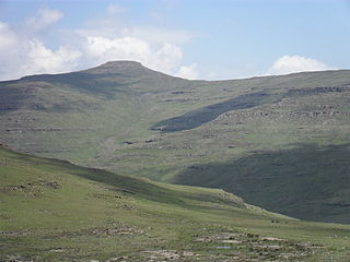
Mont-aux-Sources is a mountain in Southern Africa, forming one of the highest portions of the Drakensberg Range. It is mostly within Lesotho, with parts in the KwaZulu-Natal and Free State provinces of South Africa.

<span class="mw-page-title-main">Tupungato</span> Mountain in Argentina

Tupungato, one of the highest mountains in the Americas, is a massive Andean lava dome dating to Pleistocene times. It lies on the Argentina–Chile border, between the Chilean Metropolitan Region and the Argentine province of Mendoza, about 100 km (62 mi) south of Aconcagua, the highest peak of both the Southern and Western hemispheres. Immediately to its southwest is the active Tupungatito volcano, which last erupted in 1987.

<span class="mw-page-title-main">Mount Tahat</span> Highest mountain peak in Algeria

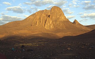
Mount Tahat is the highest mountain peak in Algeria. It sits at an elevation of 2,908 metres. Other sources indicate an elevation of 3,003 metres (9,852 ft). Tahat is also the highest peak in the Hoggar Mountains. Its nearest city is Tamanrasset which is located 56 kilometres (35 mi) to the south.

<span class="mw-page-title-main">Maloti Mountains</span> Mountain range in Lesotho

The Maloti Mountains are a mountain range of the highlands of the Kingdom of Lesotho. They extend for about 100 km into the South African Free State. The Maloti Range is part of the Drakensberg system that includes ranges across large areas of South Africa. "Maloti" is also the plural for Loti, the currency of the Kingdom of Lesotho. The range forms the northern portion of the boundary between the Butha-Buthe District in Lesotho and South Africa's Free State.

<span class="mw-page-title-main">Mafadi</span>

Mafadi is a peak on the border of South Africa and Lesotho. At a height of 3,446.1 metres (11,306 ft), it is the highest mountain in the nation of South Africa, but is lower than Thabana Ntlenyana, the highest peak in Lesotho which is, at 3,482 metres (11,424 ft), the highest point in Southern Africa.

<span class="mw-page-title-main">Ultra-prominent peak</span> Mountain with prominence of 1,500 metres

An ultra-prominent peak, or ultra for short, is a mountain summit with a topographic prominence of 1,500 metres (4,900 ft) or more; it is also called a P1500. The prominence of a peak is the minimum height of climb to the summit on any route from a higher peak, or from sea level if there is no higher peak. There are approximately 1,524 such peaks on Earth. Some well-known peaks, such as the Matterhorn and Eiger, are not ultras because they are connected to higher mountains by high cols and therefore do not achieve enough topographic prominence.

<span class="mw-page-title-main">Topographic isolation</span> Topography measuring minimum distance to a point of equal elevation

The topographic isolation of a summit is the minimum distance to a point of equal elevation, representing a radius of dominance in which the peak is the highest point. It can be calculated for small hills and islands as well as for major mountain peaks and can even be calculated for submarine summits.

<span class="mw-page-title-main">Shan Hills</span> Mountainous zone in Yunnan, Myanmar and Thailand

The Shan Hills, also known as Shan Highland, is a vast mountainous zone that extends through Yunnan to Myanmar and Thailand. The whole region is made up of numerous peaks separated mostly by narrow valleys, as well as a few broader intermontane basins. The ranges in the area are aligned in such a way that they link to the foothills of the Himalayas further to the northwest.

<span class="mw-page-title-main">Popple Peak</span>

Popple Peak is a mountain in the Drakensberg range, South Africa. It is located on the border between South Africa and Lesotho, on the watershed that forms the border between the two countries. Popple peak is 3331 m above sea level and has an elevation of approximately 300 metres from the surrounding escarpment. It is the 13th highest peak in South Africa and it is visible from as far away as Estcourt and Ladysmith in the KwaZulu-Natal Midlands.

Lists of mountains can be organized by continent and more specifically by country and province/state:

<span class="mw-page-title-main">Reo Purgyil</span> Himalayan mountain

Reo Purgyil, sometimes known as Leo Pargial and Leo Pargil, is a mountain peak at the southern end of the Zanskar Range in the Western Himalaya. It is located on the border between Himachal Pradesh, India and Tibet, China.

References

  1. Mulsh, Cliff (1994). "Khulus". MCSA.
  2. "South African mountain list of +3300m peaks". Vertical Endeavour forum. Retrieved 15 July 2018.
  3. "Ben Macdhui". South Africa Tourism. Archived from the original on 6 June 2011. Retrieved 3 October 2010.
  4. Compassberg Archived 2013-12-03 at the Wayback Machine
  5. "Mount Horeb". geoview.info. Geoview. Retrieved 12 April 2022.
  6. Geelhoutkop - Waterberg Biosphere Reserve
  7. Nooitgedacht West, South Africa