Pinelands, Cape Town

Last updated
Pinelands
OSM Pinelands map.svg
Street map of Pinelands
South Africa Western Cape location map.svg
Red pog.svg
Pinelands
South Africa adm location map.svg
Red pog.svg
Pinelands
Africa location map.svg
Red pog.svg
Pinelands
Coordinates: 33°55′54″S18°30′46″E / 33.93167°S 18.51278°E / -33.93167; 18.51278
Country South Africa
Province Western Cape
Municipality City of Cape Town
Main Place Cape Town
Established1919
Government
   Councillor Riad Davids (DA)
Area
[1]
  Total5.86 km2 (2.26 sq mi)
Population
 (2011) [1]
  Total14,198
  Density2,400/km2 (6,300/sq mi)
Racial makeup (2011)
[1]
   Black African 13.5%
   Coloured 15.1%
   Indian/Asian 5.1%
   White 62.3%
  Other4.0%
First languages (2011)
[1]
   English 81.5%
   Afrikaans 8.4%
   Xhosa 3.5%
  Other6.5%
Time zone UTC+2 (SAST)
Postal code (street)
7405
PO box
7430
Area code (021) 531/2

Pinelands is an affluent garden city suburb located on the edge of the southern suburbs of Cape Town, South Africa, neighbouring the suburb of Thornton, and is known for its large thatched houses and green spaces. The suburb is primarily residential and is often praised for its peacefulness and abundance of trees. Pinelands is one of the few areas in Cape Town in which sale of alcohol to the public is prohibited, but some clubs have private liquor licenses. It is a popular place for senior citizens to retire to. While there are several retirement homes in the suburb, younger people are increasingly moving in.

Contents

The main road is called Forest Drive and the suburb contains two small shopping centres, namely Howard Centre (named after Ebenezer Howard who led the garden city movement) and Central Square. Dutch Reformed, Anglican, Presbyterian, Methodist and Catholic (Society of St. Pius X) churches are located near to Central Square, while Baptist, Church of England in South Africa and mainstream Catholic churches are located elsewhere in the suburb. Pinelands is served by two Metrorail railway stations: Pinelands station on the western edge of the suburb and Mutual station on the northern edge. The suburb is bisected from the north east to the south west by the Elsieskraal River, which has flowed through a large concrete drainage canal since the 1970s. Elsieskraal River also flows through the neighbouring suburb of Thornton, which is a similar residential suburb with an abundance of trees.

The postcodes for Pinelands are 7405 for street addresses and 7430 or 7450 for post office boxes. The telephone exchange codes for Pinelands are predominantly 531 and 532 (within the 021 dialling code for Cape Town).

History

Old postbox in The Mead. Boite a lettres sud-africaine.jpg
Old postbox in The Mead.

The layout of Pinelands is based on the then revolutionary Garden Cities methodology of town planning by the British town-planner, Sir Ebenezer Howard. It was originally a Victorian era farm named Uitvlugt that had thousands of pine trees planted in it, and was later deemed an economic failure by the Department of Forestry. In the aftermath of the outbreak of the bubonic plague in Cape Town in February 1901, the colonial health authorities invoked Public Health Act of 1897 and quickly established a location in Uitvlugt forest station (modern day Pinelands). Black Africans living in District Six were rounded up under armed guard and taken to the location of Uitvlugt. This area was initially established primarily to quarantine Black Africans who were forcibly relocated after the outbreak of the disease, furthering efforts of the government at the time to push Black and Coloured communities to the outskirts of the city. This marked the beginning of forced removals in Cape Town in the twentieth century.

Almost 22 years later, the land was then granted to "The Garden Cities Trust" and the founding Deed of Trust was signed in 1919. One of the first members of the trust, Richard Stuttaford (head of the department store Stuttafords), made a £10,000 gift donation to serve as capital, and a loan of £15,000 from the government was invested in Pinelands. The trust brought in an overseas expert, Albert John Thompson, in 1920 to design the area.

The first (thatched) house in Pinelands to be occupied was 3 Mead Way and was built in February 1922. The house and entire street, including The Mead were declared a national monument in 1983. The original township area is currently a proposed heritage area. Pinelands converted to a municipality in 1948 and in 1996 merged into the City of Cape Town metropolitan municipality. The old Pinelands Town Council offices now accommodate the Pinelands Subcouncil.

Demographics

According to the 2011 census, the population of Pinelands was 14,198 people in 4,917 households. The following tables show various demographic data about Pinelands from that census. [2]

Gender
GenderPopulation%
Female7,59653.5%
Male6,60246.5%
Ethnic Group
GroupPopulation%
Black African 1,91713.5%
Coloured 2,14215.1%
Indian/Asian 7205.1%
White 8,84562.3%
Other5744.0%
Home Language
LanguagePopulation%
English 10,86881.5%
Afrikaans 1,1258.4%
Xhosa 4703.5%
Other SA languages2972.2%
Other languages5684.3%
Age
Age rangePopulation%
0–48055.7%
5–141,51710.7%
15–242,02314.3%
25–647,50852.9%
65+2,34316.5%

Politics

Pinelands is part of ward 53 of the City of Cape Town. [3] The ward also includes Thornton, Maitland Garden Village, Epping Industria 1, Ndabeni and part of Maitland; the current ward councillor is Riad Davids of the Democratic Alliance. [4] Of the six voting districts in this ward, three of them cover Pinelands: the voting stations are at the Pinelands Primary School, Pinelands High School, and Pinehurst Primary School. Generally, the majority of voters in the Pinelands area of the Ward vote for the Democratic Alliance.

The following tables show the sum of the votes cast in the three Pinelands voting districts at the most recent national, provincial and local elections.

National election (2019)
PartyVotes%
Democratic Alliance 5,49274.7%
African National Congress 89412.2%
African Christian Democratic Party 2954.0%
Good 1462.0%
Economic Freedom Fighters 1431.9%
26 other parties3865.2%
Total7,356100%
Provincial election (2019)
PartyVotes%
Democratic Alliance 5,89280.4%
African National Congress 5137.0%
Good 2883.9%
African Christian Democratic Party 2072.8%
Economic Freedom Fighters 1301.8%
22 other parties2984.1%
Total7,328100%
Local election (2021)

Proportional Representation vote

PartyVotes%
Democratic Alliance 4,65881.0%
Good 3145.5%
African Christian Democratic Party 1963.4%
African National Congress 1642.9%
46 other parties41.87.3%
Total5,750100%
Local election (2021)

Ward vote

CandidateVotes%
Riad Davids (DA)5,14582.7%
Ingrid Simons (Good)2694.3%
Richard Bougard (ACDP)2484.0%
Brenda Skelenge (ANC)1923.1%
30 other candidates3685.9%
Total7,122100%

Road names

Many of the road names in Pinelands have originated from local history or from places in England. One such road is named Uitvlugt (original Dutch) after the historical farm of the same name that covered what is now Pinelands. There are also roads named Letchworth and Welwyn after the first two garden cities in England. Other roads in Pinelands are named after places in the Lake District in England, the Royal Family as well as the names of birds, trees and flowers. Curiously, despite the attitude displayed to the sale of alcohol in Pinelands, there is a section where all the roads are named after well known wine farms.

Schools

In Pinelands there are three public primary schools, each of which is commonly known in the community by a colour: Pinelands Primary School ("The Blue School"), Pinelands North Primary School ("The Red School") and Pinehurst Primary School ("The Green School"). Pinelands High School is a public high school, centrally located in the suburb. Cannons Creek Independent School is a private combined primary and high school. Grace Primary School is a Christian primary school embracing a Charlotte Mason education philosophy. [5] There are three private pre-primaries in Pinelands: Meerendal Pre-Primary, La Gratitude Pre-Primary, Learn and Play Centre Pre-School and Old Mutual for their employees. The high school campus of Vista Nova (a school for children with cerebral palsy and other special needs) is located in the suburb. The Pinelands Campus of the College of Cape Town while located in Maitland is on the northern edge of Pinelands and draws students from all over Cape Town.

Sports

Pinelands has sporting facilities including tennis and lawn bowling clubs. Other sports include the cricket and hockey clubs situated at The Oval sports grounds situated on St. Stephens Road just off Forest Drive. Pinelands hockey club was founded in 1937 and is currently one of the largest clubs in the country fielding 12 men’s teams and 7 ladies teams in the Western Province Hockey Union league. Both the men’s and ladies’ first teams play in the Grand Challenge league with the men's team having won the title for the first time in 2006. In 2008 Pinelands Hockey Club produced three Olympians – Marvin Bam, Paul Blake and Austin Smith. Austin Smith was made the South African Men's Captain, having first played hockey for the Red School and the Pinelands High School.

Coat of arms

Coat of arms of Pinelands Coat of arms of Pinelands.svg
Coat of arms of Pinelands

In January 1949, the municipal council assumed a coat of arms, designed by F. de Beaumont Beech. [6] It registered the arms with the Cape Provincial Administration in July 1954 [7] and at the Bureau of Heraldry in July 1979. [8]

The arms were : Or, on a chevron Gules, between three fir-cones Sable, slipped and leaved Vert, three annulets Or (i.e. a golden shield depicting, from top to bottom, two black fir-cones with green leaves, a red chevron displaying three golden rings, and another black fir-cone with green leaves). The crest was a squirrel holding an acorn, and the motto was Fides – prudentia – labor.

See also

Related Research Articles

Garden City or Garden Suburb may refer to:

<span class="mw-page-title-main">Rondebosch</span> Place in Western Cape, South Africa

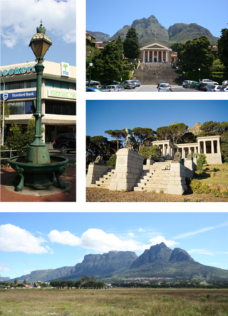
Rondebosch is one of the Southern Suburbs of Cape Town, South Africa. It is primarily a residential suburb, with shopping and business districts as well as the main campus of the University of Cape Town.

Ndabeni is an industrial suburb of Cape Town, South Africa, mainly occupied by light industries such as textiles and clothing. It is located about 6 km east of Cape Town city centre and is serviced by a railway station. Ndabeni is bordered to the south east by Pinelands and to the north by Maitland. Its postcode is 7405.

Edgemead is one of the Northern Suburbs of Cape Town. It is one of several garden cities of South Africa, the first being Pinelands in the southern suburbs. Edgemead is mainly residential, and as the name 'garden city' suggests, is noted for its trees, gardens and generally pleasant environment. Other 'garden cities' that have followed are Pinehurst near Durbanville on the northwestern outskirts of the Cape Metropole, still under construction but already occupied, and Sunningdale near Milnerton.

<span class="mw-page-title-main">Durbanville</span> Town in Western Cape, South Africa

Durbanville, previously called Pampoenkraal, is a town in the Western Cape province of South Africa, part of the greater Cape Town metropolitan area. Durbanville is a semi-rural residential suburb on the north-eastern outskirts of the metropolis surrounded by farms producing wine and wheat.

<span class="mw-page-title-main">Southern Suburbs, Cape Town</span> Sub-region of Cape Town, South Africa

The Southern Suburbs are a group of Anglophone suburbs in Cape Town, Western Cape, South Africa. This group includes, among others, Observatory, Mowbray, Pinelands, Rosebank, Rondebosch, Rondebosch East, Newlands, Claremont, Lansdowne, Kenilworth, Bishopscourt, Constantia, Wynberg, Ottery, Plumstead, Diep River, Bergvliet and Tokai. The area is also commonly referred to as the Cape Peninsula, often including the towns further South such as Fish Hoek.

<span class="mw-page-title-main">Claremont, Cape Town</span> Place in Western Cape, South Africa

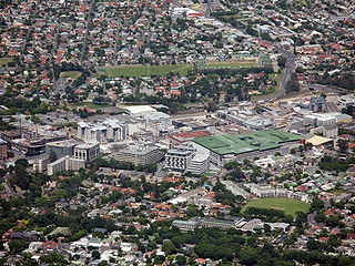
Claremont is a suburb of Cape Town, South Africa. It is situated 9 kilometres south of the city, and is one of the so-called "Southern Suburbs", it is situated alongside Lansdowne. It is an important commercial and residential area, which is currently experiencing significant growth and development.

<span class="mw-page-title-main">Gardens, Cape Town</span> Inner-city suburb of Cape Town in Western Cape, South Africa

Gardens is an affluent inner-city suburb of Cape Town located just to the south of the city centre located in the higher elevations of the "City Bowl" and directly beneath Table Mountain and Lion's Head. It is home to several national museums such as Iziko South African National Gallery and the Iziko South African Museum. The University of Cape Town also houses its Fine Arts department in the suburb, at Michaelis School of Fine Art. Company's Garden, South Africa's oldest garden, a public park and heritage site is a focal point of the suburb. The area is also home to the oldest synagogue in Southern Africa, the Old Shul and its successor, the Gardens Shul, "The Mother Synagogue of South Africa."

<span class="mw-page-title-main">Green Point, Cape Town</span> Suburb of Cape Town in Western Cape, South Africa

Green Point is an affluent suburb on the Atlantic Seaboard of Cape Town, South Africa located to the north west of the central business district and. It is home to Cape Town Stadium, a major sporting venue that was built for the 2010 FIFA World Cup. Sea Point promenade runs through the suburb, connecting it to Three Anchor Bay and Sea Point, a popular Jewish neighbourhood. Somerset Road forms the main thoroughfare lined by restaurants, cafés, delis, boutiques and nightclubs.

Plumstead is a residential suburb situated in the Southern Suburbs of Cape Town in the Western Cape Province of South Africa.

<span class="mw-page-title-main">Gardens Commercial High School</span> Public school in Cape Town, Western Cape, South Africa

Gardens Commercial High School is a coeducational inner city Secondary School in Cape Town, South Africa with learners aged 12–18 years. In 2006 the school was designated a Business, Commerce and Management (BCM) Focus School. As such, Gardens Commercial is part of an education intervention that aims to redress the Apartheid education system. The school is a lead institution that supports learners with exceptional interest, talent, interest or aptitude in the field of business, commerce and management. Gardens Commercial offers the following focus field subjects: Accounting, Business Studies, Economics and Computer Applications Technology.

<span class="mw-page-title-main">Rondebosch East</span> Residential suburb of Cape Town, in Western Cape, South Africa

Rondebosch East is a residential suburb of Cape Town, South Africa, about 7 kilometres (4.3 mi) south-east of the city centre. As the name suggests, it is located to the east of the neighbouring suburb of Rondebosch. As of 2001 it had a population of approximately 4,600 people in an area of just over 1 square kilometre (0.4 sq mi). A large common, similar to but smaller than Rondebosch Common, is located in the center of the suburb.

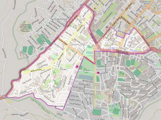
Lansdowne is a suburb in Cape Town, South Africa. situated 10 kilometres southeast of Cape Town City Centre, surrounded by the suburbs of Rondebosch East, Crawford, Wetton, Claremont, Kenwyn and Athlone. Lansdowne is served by a railway station of the same name, on the Cape Flats Line.

<span class="mw-page-title-main">Thornton, Cape Town</span> Place in Western Cape, South Africa

Thornton is a southern suburb of Cape Town, South Africa. Thornton is situated only 10 kilometres (6 mi) east of the city centre, adjacent to Pinelands. Like Pinelands, Thornton is a mainly residential suburb with an abundance of trees. It is bordered by the Elsieskraal River, Pinelands, Viking Way, and the M7 Jakes Gerwel Drive. Many of the streets in Thornton are named after Viking themes, such as Thor Circle, Odin Drive and Viking Way. Others are named after trees, such as Poplar Avenue and Sipres Avenue.

<span class="mw-page-title-main">Maitland, Cape Town</span> Place in Western Cape, South Africa

Maitland is a suburb of Cape Town, South Africa.

<span class="mw-page-title-main">Black River (Cape Town)</span> River in Western Cape province, South Africa

The Black River(Swartrivier) is a river in Cape Town, South Africa. It is a tributary of the Salt River together with the Liesbeeck River and the Elsieskraal River. It rises in Arderne Gardens and flows underground initially beneath Main Road and the railway line, before continuing as a canal through Claremont and Rondebosch, then uncanalised through Mowbray, Observatory and Maitland after which it joins the Salt River. Its catchment is part of the Central Management Area of the City of Cape Town and the city has canalised 58% of the river.

<span class="mw-page-title-main">Richard Stuttaford</span>

Richard Stuttaford was a South African businessman and parliamentarian.

Brooklyn is a suburb of Cape Town, Western Cape with a population of 10,941 people. It lies to the north of Maitland, east of the Atlantic Ocean and Paarden Eiland, and west of Air Force Base Ysterplaat. The Black River flows through a section of Brooklyn.

<span class="mw-page-title-main">Outline of Cape Town</span> List of links to articles about Cape Town on Wikipedia

The following outline is provided as an overview of and topical guide to Cape Town:

College of Cape Town (CCT), is a public TVET College located in Cape Town, South Africa, in the province of Western Cape, and it mainly serves students from the Southern Suburbs, Northern Suburbs region, along with Klipfontein District. The college is one of the oldest TVET institutions in Cape Town. CCT was founded in 1900 making it the oldest TVET college in South Africa.

References

  1. 1 2 3 4 "Sub Place Pinelands". Census 2011.
  2. "2011 Census Suburb Pinelands" (PDF). City of Cape Town. July 2013. Retrieved 8 April 2020.
  3. "Western Cape/City of Cape Town Metropolitan Municipality/Ward Number 53". Municipal Demarcation Board. Archived from the original on 2007-09-27. Retrieved 2007-06-09.
  4. "Councillor details: Riad Davids". City of Cape Town . Retrieved 13 November 2021.
  5. "HOME". Grace Primary School. Retrieved 2021-11-13.
  6. Western Cape Archives : Pinelands Municipal Minutes (27 January 1949).
  7. Cape of Good Hope Official Gazette 2711 (23 July 1954).
  8. http://www.national.archsrch.gov.za%5B%5D