Pinsdorf

Last updated
Pinsdorf
Wappen at pinsdorf.png
Coat of arms
Austria adm location map.svg
Red pog.svg
Pinsdorf
Location within Austria
Coordinates: 47°55′49″N13°46′01″E / 47.93028°N 13.76694°E / 47.93028; 13.76694 Coordinates: 47°55′49″N13°46′01″E / 47.93028°N 13.76694°E / 47.93028; 13.76694
Country Austria
State Upper Austria
District Gmunden
Government
   Mayor Dieter Helms (SPÖ)
Area
[1]
  Total12.47 km2 (4.81 sq mi)
Elevation
493 m (1,617 ft)
Population
 (2018-01-01) [2]
  Total3,849
  Density310/km2 (800/sq mi)
Time zone UTC+1 (CET)
  Summer (DST) UTC+2 (CEST)
Postal code
4812
Area code 07612
Vehicle registration GM
Website www.pinsdorf.ooe.gv.at
Parish church Saint Matthias Pinsdorf - Kirche.JPG
Parish church Saint Matthias

Pinsdorf is a village in the Austrian state of Upper Austria in the district of Gmunden.

Contents

History

The Bauernhügel is an obelisk-styled memorial in Pinsdorf, constructed to pay tribute to people killed in the brutal Battle of Gmunden between the Bavarian stadtholder Adam Graf von Herbertstorff and the farmers, who resided in Pinsdorf (German page de:Oberösterreichischer Bauernkrieg). The farmers fought against the counter-reformation. A plaque on the memorial states the remains of the slain farmers are buried under the hill (see below: Coat of arms).

Geography

The river Aurach flows through the village. There are several notable hills in the settlement's immediate surroundings, including the Pinsdorfberg, the Gmundnerberg, the Vöcklaberg and the Kronberg.

Local Outline

The municipality includes the following 10 villages (in brackets population as of January 1, 2018):

Population

Historical population
YearPop.±%
18691,324    
18801,304−1.5%
18901,378+5.7%
19001,552+12.6%
19101,721+10.9%
19231,684−2.1%
19341,823+8.3%
19391,814−0.5%
19512,057+13.4%
19612,349+14.2%
19712,716+15.6%
19812,806+3.3%
19913,176+13.2%
20013,441+8.3%
20163,821+11.0%

Politics

The results of the last election of the local government in 2015:

Dieter Helms (SPÖ) is the current mayor of Pinsdorf. The current vice-mayor is Christa Schiemel(SPÖ)

Twin town

Related Research Articles

Dornbirn Place in Vorarlberg, Austria

Dornbirn[ˈdɔʁnbɪʁn] is a city in the westernmost Austrian state of Vorarlberg. It is the administrative centre for the district of Dornbirn, which also includes the town of Hohenems, and the market town Lustenau.

Mattersburg Place in Burgenland, Austria

Mattersburg is a town in Burgenland, Austria. It is the administrative center of the District of Mattersburg and was home to former Bundesliga football team, SV Mattersburg.
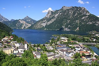
Gmunden Place in Upper Austria, Austria

Gmunden is a town in Upper Austria, Austria in the district of Gmunden. It has 13,204 inhabitants. It is much frequented as a health and summer resort, and has a variety of lake, brine, vegetable and pine-cone baths, a hydropathic establishment, inhalation chambers, whey cure, etc. It is also an important centre of the salt industry in Salzkammergut.

Pinkafeld Place in Burgenland, Austria

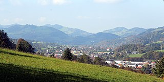
Pinkafeld is a city in Burgenland in Austria and the second largest settlement in the district Oberwart.

Ebensee Place in Upper Austria, Austria

Ebensee is a market town in the Traunviertel region of the Austrian state of Upper Austria, located within the Salzkammergut Mountains at the southern end of the Traunsee. The regional capital Linz lies approximately 90 km (56 mi) to the north, nearest towns are Gmunden and Bad Ischl. The municipality also comprises the Katastralgemeinden of Langwies, Oberlangbath, Rindbach, Kohlstatt and Roith.

Frauenkirchen Place in Burgenland, Austria

Frauenkirchen is an Austrian town in the district of Neusiedl am See, Burgenland.

Kobersdorf Place in Burgenland, Austria

Kobersdorf is an Austrian market town in Oberpullendorf, Burgenland.

Deutschkreutz Place in Burgenland, Austria

Deutschkreutz is an Austrian market town in the district of Oberpullendorf in the state of Burgenland.

Lackenbach Place in Burgenland, Austria

Lackenbach is an Austrian municipality in the District of Oberpullendorf, Burgenland.

Sankt Aegyd am Neuwalde Place in Lower Austria, Austria

Sankt Aegyd am Neuwalde is a market town in the district of Lilienfeld, Lower Austria.

Turnau, Styria Place in Styria, Austria

Turnau is a market town at the foot of the Hochschwab in the Styrian District of Bruck-Mürzzuschlag.

Unterach am Attersee Place in Upper Austria, Austria

Unterach is a village in the Austria state of Upper Austria on the southern shore of lake Attersee in the centre of the Salzkammergut region.

Murfeld Place in Styria, Austria

Murfeld was the southernmost municipality of the Austrian district of Südoststeiermark. As of January 1st, 2020, the Municipality was split between the Municipalities of Sankt Veit am Vogau and Straß in Steiermark, to the east, in the district of Leibnitz. The Catastral Subdivision of Seibersdorf bei Sankt Veit (289) merged with Sankt Veit am Vogau. The Catastral Subdivisions of Lichendorf (494), Oberschwarza (152), Unterschwarza (213) and Weitersfeld (527) merged with Straß in Steiermark.

Stinatz Place in Burgenland, Austria

Stinatz is a town in the district of Güssing in Burgenland in Austria. According to the last census 62% of the population are members of the Burgenland Croat minority.

Hauskirchen Place in Lower Austria, Austria

Hauskirchen is a town in the district of Gänserndorf in the Austrian state of Lower Austria.

Rohrendorf bei Krems Place in Lower Austria, Austria

Rohrendorf bei Krems is a municipality in the district of Krems-Land in the Austrian state of Lower Austria.

Sankt Veit an der Gölsen Place in Lower Austria, Austria

Sankt Veit an der Gölsen is a town in the district of Lilienfeld in the Austrian federal state of Lower Austria.

Roitham am Traunfall Place in Upper Austria, Austria

Roitham am Traunfall is a municipality in the district of Gmunden in the Austrian state of Upper Austria.

Vorchdorf Place in Upper Austria, Austria

Vorchdorf is a market town in the district of Gmunden in Upper Austria, Austria, as well as the name of the municipal area ("Gemeinde") that the town and others occupy. As of the 2005 census, the town of Vorchdorf had a population of 7,287 inhabitants.

Windischgarsten Place in Upper Austria, Austria

Windischgarsten is a municipality in the district of Kirchdorf an der Krems in the Austrian state of Upper Austria. Since 1964, the town has been classified as a Luftkurort, a mountain spa town.

References

  1. "Dauersiedlungsraum der Gemeinden Politischen Bezirke und Bundesländer - Gebietsstand 1.1.2018". Statistics Austria. Retrieved 10 March 2019.
  2. "Einwohnerzahl 1.1.2018 nach Gemeinden mit Status, Gebietsstand 1.1.2018". Statistics Austria. Retrieved 9 March 2019.