Pearl Creek Colony is a Hutterite colony and census-designated place (CDP) in Beadle County, South Dakota, United States. It was first listed as a CDP prior to the 2020 census. The population of the CDP was 99 at the 2020 census.
Newdale Colony is a Hutterite colony and census-designated place (CDP) in Brookings County, South Dakota, United States. It was first listed as a CDP prior to the 2020 census. The population of the CDP was 6 at the 2020 census.
Rolland Colony is a Hutterite colony and census-designated place (CDP) in Brookings County, South Dakota, United States. It was first listed as a CDP prior to the 2020 census. The population of the CDP was 53 at the 2020 census.
Cedar Grove Colony is a Hutterite colony and census-designated place (CDP) in Brule County, South Dakota, United States. The population was 0 at the 2020 census. It was first listed as a CDP prior to the 2020 census.
Mayfield Colony is a Hutterite colony and census-designated place (CDP) in Clark County, South Dakota, United States. The population was 146 at the 2020 census. It was first listed as a CDP prior to the 2020 census.
Deerfield Colony is a Hutterite colony and census-designated place (CDP) in Edmunds County, South Dakota, United States. It was first listed as a CDP prior to the 2020 census. The population of the CDP was 128 at the 2020 census.
Blumengard Colony is a Hutterite colony and census-designated place (CDP) in Faulk County, South Dakota, United States. The population was 0 at the 2020 census. It was first listed as a CDP prior to the 2020 census.
Brentwood Colony is a Hutterite colony and census-designated place (CDP) in Faulk County, South Dakota, United States. The population was 116 at the 2020 census. It was first listed as a CDP prior to the 2020 census.
Thunderbird Colony is a Hutterite colony and census-designated place (CDP) in Faulk County, South Dakota, United States. The population was 7 at the 2020 census. It was first listed as a CDP prior to the 2020 census.
Millbrook Colony is a Hutterite colony and census-designated place (CDP) in Hanson County, South Dakota, United States. The population was 98 at the 2020 census. It was first listed as a CDP prior to the 2020 census.
New Elm Spring Colony is a Hutterite colony and census-designated place (CDP) in Hutchinson County, South Dakota, United States. The population was 100 at the 2020 census. It was first listed as a CDP prior to the 2020 census.
Old Elm Spring Colony is a Hutterite colony and census-designated place (CDP) in Hutchinson County, South Dakota, United States. The population was 114 at the 2020 census. It was first listed as a CDP prior to the 2020 census.
Newport Colony is a Hutterite colony and census-designated place (CDP) in Marshall County, South Dakota, United States. The population was 114 at the 2020 census. It was first listed as a CDP prior to the 2020 census.
Westwood Colony is a Hutterite colony and census-designated place (CDP) in Marshall County, South Dakota, United States. The population was 8 at the 2020 census. It was first listed as a CDP prior to the 2020 census.
Grassland Colony is a census-designated place (CDP) and Hutterite colony in McPherson County, South Dakota, United States. It was first listed as a CDP prior to the 2020 census. The population of the CDP was 127 at the 2020 census.
Shannon Colony is a census-designated place (CDP) and Hutterite colony in Miner County, South Dakota, United States. It was first listed as a CDP prior to the 2020 census. The population of the CDP was 1 at the 2020 census.
Pleasant Valley Colony is a census-designated place (CDP) and Hutterite colony in Moody County, South Dakota, United States. The population was 6 at the 2020 census. It was first listed as a CDP prior to the 2020 census.
Camrose Colony is a census-designated place (CDP) and Hutterite colony in Spink County, South Dakota, United States. It was first listed as a CDP prior to the 2020 census. The CDP had a population of 76 at the 2020 census.
Cameron Colony is a census-designated place (CDP) and Hutterite colony in Turner County, South Dakota, United States. The population was 79 at the 2020 census. It was first listed as a CDP prior to the 2020 census.
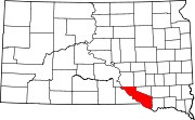
Jamesville Colony is a census-designated place (CDP) and Hutterite colony in Yankton County, South Dakota, United States. The population was 110 at the 2020 census. It was first listed as a CDP prior to the 2020 census.