Pleasant Hill, Illinois

Last updated

Pleasant Hill
Pike County Illinois Incorporated and Unincorporated areas Pleasant Hill Highlighted.svg
Location of Pleasant Hill in Pike County, Illinois.
Illinois in United States (US48).svg
Location of Illinois in the United States
Coordinates: 39°26′36″N90°52′23″W / 39.44333°N 90.87306°W / 39.44333; -90.87306
CountryUnited States
StateIllinois
County Pike
Area
[1]
  Total0.79 sq mi (2.05 km2)
  Land0.77 sq mi (1.98 km2)
  Water0.03 sq mi (0.06 km2)
Elevation
[2]
459 ft (140 m)
Population
 (2020)
  Total924
  Density1,207.84/sq mi (466.15/km2)
Time zone UTC-6 (CST)
  Summer (DST) UTC-5 (CDT)
ZIP Code(s)
62366
Area code 217
FIPS code 17-60534
GNIS feature ID2399692 [2]
Wikimedia CommonsPleasant Hill, Illinois

Pleasant Hill is a village in Pike County, Illinois, United States. The population was 966 at the 2010 census.

Contents

Pleasant Hill is the site of the annual Pike County Fair, as well as the location of the Bi-State Annual Demolition Derby, which was previously held at Six Flags St. Louis in Eureka, Missouri.

The village also happens to have an annual Fourth of July celebration which attracts many throughout the county. The fireworks display can be seen by many surrounding towns.

Geography

Pleasant Hill is located at 39°26′36″N90°52′23″W / 39.44333°N 90.87306°W / 39.44333; -90.87306 (39.443315, -90.873132). [3]

According to the 2010 census, Pleasant Hill has a total area of 0.805 square miles (2.08 km2), of which 0.78 square miles (2.02 km2) (or 96.89%) is land and 0.025 square miles (0.06 km2) (or 3.11%) is water. [4]

Demographics

Historical population
CensusPop.Note
1870 230
1880 27620.0%
1890 31012.3%
1900 39025.8%
1910 57647.7%
1920 433−24.8%
1930 70061.7%
1940 7060.9%
1950 85621.2%
1960 95011.0%
1970 1,06412.0%
1980 1,1124.5%
1990 1,030−7.4%
2000 1,0471.7%
2010 966−7.7%
2020 924−4.3%
U.S. Decennial Census [5]

Per the 2010 US Census, Pleasant Hill had 966 people. Among non-Hispanics this includes 949 White, 3 Black, 1 some other race, & 1 from two or more races. The Hispanic or Latino population included 12 people.

There were 406 households, out of which 29.1% had children under the age of 18 living with them, 53.4% were married couples living together, 10.6% had a female householder with no husband present, and 32.5% were non-families. 28.8% of all households were made up of individuals, and 32.0% had someone living alone who was 65 years of age or older. The average household size was 2.38 and the average family size was 2.89.

The village population was spread out, with 76.1% over the age of 18 and 17.2% who were 65 years of age or older. The median age was 41.3 years. The gender ratio was 48.8% male & 51.2% female. Among 406 occupied households, 79.1% were owner-occupied & 20.9% were renter-occupied.

As of the census [6] of 2000, there were 1,047 people, 442 households, and 288 families residing in the village. The population density was 1,372.8 inhabitants per square mile (530.0/km2). There were 483 housing units at an average density of 633.3 per square mile (244.5/km2). The racial makeup of the village was 98.66% White, 0.57% from other races, and 0.76% from two or more races. Hispanic or Latino of any race were 0.57% of the population.

There were 442 households, out of which 30.5% had children under the age of 18 living with them, 50.9% were married couples living together, 10.4% had a female householder with no husband present, and 34.8% were non-families. 32.8% of all households were made up of individuals, and 21.9% had someone living alone who was 65 years of age or older. The average household size was 2.32 and the average family size was 2.88.

In the village, the population was spread out, with 25.8% under the age of 18, 5.3% from 18 to 24, 24.4% from 25 to 44, 21.4% from 45 to 64, and 23.2% who were 65 years of age or older. The median age was 40 years. For every 100 females, there were 96.1 males. For every 100 females age 18 and over, there were 83.7 males.

The median income for a household in the village was $25,156, and the median income for a family was $31,029. Males had a median income of $24,583 versus $16,534 for females. The per capita income for the village was $12,682. About 10.8% of families and 17.0% of the population were below the poverty line, including 19.3% of those under age 18 and 21.0% of those age 65 or over.

Education

Pleasant Hill has two schools: an elementary school for Grades Kindergarten - 8 and a High School for Grades 9 - 12.

Related Research Articles

<span class="mw-page-title-main">Pleasant Hill, Iowa</span> City in Iowa, United States

Pleasant Hill is a city in Polk County, Iowa, United States. The population was 10,147 at the time of the 2020 census. It is part of the Des Moines metropolitan area. As of July 2005, Pleasant Hill was assigned a ZIP code, 50327.

<span class="mw-page-title-main">Pleasant Hill, Sabine Parish, Louisiana</span> Village in Louisiana, United States

Pleasant Hill is a village in Sabine Parish in western Louisiana, United States. As of the 2010 census, the village population was 1,232. It is best known as the site of The Battle of Pleasant Hill, a Civil War engagement fought in April 1864.

Caratunk is a town in Somerset County, Maine, United States. The population was 81 at the 2020 census.

<span class="mw-page-title-main">Pleasant Hills, Maryland</span> Census-designated place in Maryland, United States

Pleasant Hills is a census-designated place (CDP) in Harford County, Maryland, United States. The population was 3,379 at the 2010 census, up from 2,851 in 2000. There is no post office with the designation "Pleasant Hills"; most of the residents have either Fallston or Kingsville addresses and consider themselves as belonging to those communities.

<span class="mw-page-title-main">Mecosta, Michigan</span> Village in Michigan, United States

Mecosta is a village in Mecosta County in the U.S. state of Michigan. The population was 386 at the 2020 census, down from 457 in 2010. The village is within Morton Township. Mecosta Township, which is also in Mecosta County, is located several miles to the west.

Pleasant Hill Township is a township in Winona County, Minnesota, United States. The population was 531 at the 2010 census.

<span class="mw-page-title-main">Pleasant Hill, Missouri</span> City in Missouri, United States

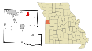
Pleasant Hill is a city in Cass and Jackson counties, Missouri, United States. The population was 8,113 at the 2010 census. It is part of the Kansas City metropolitan area.

<span class="mw-page-title-main">Pleasant Dale, Nebraska</span> Village in Seward County, Nebraska, United States

Pleasant Dale is a village in Seward County, Nebraska, United States. It is part of the Lincoln, Nebraska Metropolitan Statistical Area. The population was 205 at the 2010 census.

<span class="mw-page-title-main">Baldwin Park, Missouri</span> Village in Missouri, United States

Baldwin Park is a village in Cass County, Missouri, United States. The population was 92 at the 2010 census. It is part of the Kansas City metropolitan area.

<span class="mw-page-title-main">Mount Pleasant, New York</span> Town in New York, United States

Mount Pleasant is a town in Westchester County, New York, United States, in the New York metropolitan area. As of the 2020 census, the town population was 44,436. The hamlets of Valhalla, Hawthorne, Pocantico Hills, and Thornwood, and the villages of Pleasantville, Sleepy Hollow, and a small portion of Briarcliff Manor lie within the town.

<span class="mw-page-title-main">Pleasant City, Ohio</span> Village in Ohio, United States

Pleasant City is a village in Guernsey County, Ohio, United States. The population was 400 at the 2020 census.

<span class="mw-page-title-main">Pleasant Run, Ohio</span> Census-designated place in Ohio, United States

Pleasant Run is a census-designated place (CDP) in Colerain Township, Hamilton County, Ohio, United States. The population was 4,861 at the 2020 census.

<span class="mw-page-title-main">Pleasant Hill, Ohio</span> Village in Ohio, United States

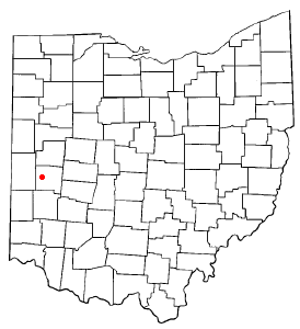
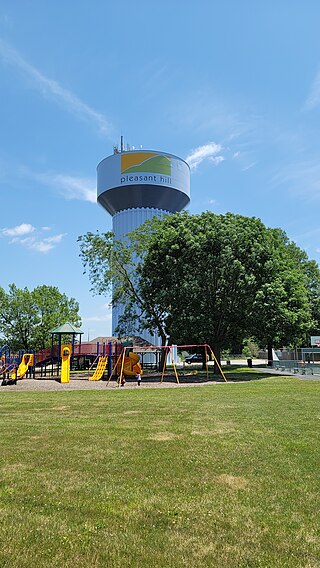
Pleasant Hill is a village in Miami County, Ohio, United States. The population was 1,241 at the 2020 census. It is part of the Dayton Metropolitan Statistical Area.

<span class="mw-page-title-main">Pleasant Plain, Ohio</span> Village in Ohio, United States

Pleasant Plain is a village in Harlan Township, Warren County, Ohio, United States. The population was 129 at the 2020 census.

<span class="mw-page-title-main">Plymptonville, Pennsylvania</span> Census-designated place in Pennsylvania, United States

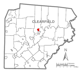
Plymptonville is a census-designated place (CDP) in Clearfield County, Pennsylvania, United States. The population was 972 at the 2020 census.

<span class="mw-page-title-main">Sheakleyville, Pennsylvania</span> Borough in Pennsylvania, United States

Sheakleyville is a borough in northern Mercer County, Pennsylvania, United States. The population was 142 at the 2010 census, a figure which increased to 150 tabulated residents in 2020. It is part of the Hermitage micropolitan area.

<span class="mw-page-title-main">Merrifield, Virginia</span> Census-designated place in Virginia, United States

Merrifield is a census-designated place (CDP) in Fairfax County, Virginia, United States. The population was 20,488 at the 2020 census.

<span class="mw-page-title-main">Belmont, West Virginia</span> Town in West Virginia, United States

Belmont is a town in Pleasants County, West Virginia, United States. It is part of the Parkersburg–Vienna metropolitan area. The population was 872 at the 2020 census. Belmont was incorporated on April 19, 1946, by the Circuit Court of Pleasants County. The city was named for the beautiful hills in the area.

<span class="mw-page-title-main">Lima, Pepin County, Wisconsin</span> Town in Wisconsin, United States

Lima is a town in Pepin County, Wisconsin, United States. The population was 693 at the 2020 census. The unincorporated community of Tarrant is located in the town.

Spurgeon is a census-designated place (CDP) in Sullivan and Washington counties in the U.S. state of Tennessee. The population was 3,957 at the 2010 census.

References

  1. "2020 U.S. Gazetteer Files". United States Census Bureau. Retrieved March 15, 2022.
  2. 1 2 U.S. Geological Survey Geographic Names Information System: Pleasant Hill, Illinois
  3. "US Gazetteer files: 2010, 2000, and 1990". United States Census Bureau. February 12, 2011. Retrieved April 23, 2011.
  4. "G001 - Geographic Identifiers - 2010 Census Summary File 1". United States Census Bureau. Archived from the original on February 13, 2020. Retrieved December 25, 2015.
  5. "Census of Population and Housing". Census.gov. Retrieved June 4, 2015.
  6. "U.S. Census website". United States Census Bureau . Retrieved January 31, 2008.