Pleasant Plain, Iowa

Last updated

Pleasant Plain, Iowa
Friends church pleasant plain iowa.jpg
Friends Church
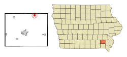
Jefferson County Iowa Incorporated and Unincorporated areas Pleasant Plain Highlighted.svg
Location of Pleasant Plain, Iowa
Coordinates: 41°08′50″N91°51′35″W / 41.14722°N 91.85972°W / 41.14722; -91.85972
Country Flag of the United States.svg  United States
State Flag of Iowa.svg  Iowa
County Jefferson
Area
[1]
  Total1.01 sq mi (2.62 km2)
  Land1.01 sq mi (2.62 km2)
  Water0.00 sq mi (0.00 km2)
Elevation
[2]
755 ft (230 m)
Population
 (2020)
  Total84
  Density82.92/sq mi (32.02/km2)
Time zone UTC-6 (Central (CST))
  Summer (DST) UTC-5 (CDT)
ZIP code
52540 [3]
Area code 319
FIPS code 19-63615
GNIS feature ID2396233 [2]

Pleasant Plain is a city in northeast Penn Township, Jefferson County, Iowa, United States. At the time of the 2020 census, the population was 84. [4]

Contents

Geography

According to the United States Census Bureau, the city has a total area of 1.02 square miles (2.64 km2), all land. [5]

Demographics

Historical populations
YearPop.±%
1900 280    
1910 174−37.9%
1920 164−5.7%
1930 175+6.7%
1940 171−2.3%
1950 148−13.5%
1960 147−0.7%
1970 121−17.7%
1980 144+19.0%
1990 128−11.1%
2000 131+2.3%
2010 93−29.0%
2020 84−9.7%
Source: "U.S. Census website". United States Census Bureau . Retrieved March 29, 2020. and Iowa Data Center
Source:
U.S. Decennial Census [6] [4]

2010 census

As of the census [7] of 2010, there were 93 people, 41 households, and 31 families living in the city. The population density was 91.2 inhabitants per square mile (35.2/km2). There were 47 housing units at an average density of 46.1 per square mile (17.8/km2). The racial makeup of the city was 100.0% White. Hispanic or Latino of any race were 1.1% of the population.

There were 41 households, of which 26.8% had children under the age of 18 living with them, 65.9% were married couples living together, 4.9% had a female householder with no husband present, 4.9% had a male householder with no wife present, and 24.4% were non-families. 24.4% of all households were made up of individuals, and 19.5% had someone living alone who was 65 years of age or older. The average household size was 2.27 and the average family size was 2.61.

The median age in the city was 45.5 years. 16.1% of residents were under the age of 18; 7.7% were between the ages of 18 and 24; 25.9% were from 25 to 44; 32.3% were from 45 to 64; and 18.3% were 65 years of age or older. The gender makeup of the city was 52.7% male and 47.3% female.

2000 census

As of the census [8] of 2000, there were 131 people, 52 households, and 39 families living in the city. The population density was 129.2 inhabitants per square mile (49.9/km2). There were 57 housing units at an average density of 56.2 per square mile (21.7/km2). The racial makeup of the city was 100.00% White.

There were 52 households, out of which 30.8% had children under the age of 18 living with them, 63.5% were married couples living together, 9.6% had a female householder with no husband present, and 25.0% were non-families. 19.2% of all households were made up of individuals, and 7.7% had someone living alone who was 65 years of age or older. The average household size was 2.52 and the average family size was 2.79.

In the city, the population was spread out, with 27.5% under the age of 18, 6.1% from 18 to 24, 30.5% from 25 to 44, 26.0% from 45 to 64, and 9.9% who were 65 years of age or older. The median age was 34 years. For every 100 females, there were 98.5 males. For every 100 females age 18 and over, there were 106.5 males.

The median income for a household in the city was $28,125, and the median income for a family was $31,250. Males had a median income of $26,750 versus $20,938 for females. The per capita income for the city was $14,282. There were 24.3% of families and 25.0% of the population living below the poverty line, including 50.0% of under eighteens and 20.0% of those over 64.

Related Research Articles

<span class="mw-page-title-main">Pleasant Grove, Alabama</span> City in Alabama, United States

Pleasant Grove is a city in western Jefferson County, Alabama. It is part of the Birmingham metropolitan area. Its nickname is "The Good Neighbor City". At the 2020 census, the population was 9,544.
<span class="mw-page-title-main">Whiteland, Indiana</span> Town in Indiana, United States

Whiteland is a town in Pleasant, Franklin and Clark townships, Johnson County, Indiana, United States. The population was 4,599 at the 2020 census.

<span class="mw-page-title-main">Rome, Iowa</span> Village in Iowa, United States

Rome is a village in Henry County, Iowa, United States. The population was 114 at the time of the 2020 census.
<span class="mw-page-title-main">Pleasant Hill, Iowa</span> City in Iowa, United States

Pleasant Hill is a city in Polk County, Iowa, United States. The population was 10,147 at the time of the 2020 census. It is part of the Des Moines metropolitan area. As of July 2005, Pleasant Hill was assigned a ZIP code, 50327.

<span class="mw-page-title-main">Panorama Park, Iowa</span> City in Iowa, United States

Panorama Park is a city in Scott County, Iowa, United States. The population was 139 at the time of the 2020 census. It is surrounded by Bettendorf, and is part of the Quad Cities metro area.

<span class="mw-page-title-main">Easton, Kansas</span> City in Kansas, United States

Easton is a city in Leavenworth County, Kansas, United States, and part of the Kansas City metropolitan area. As of the 2020 census, the population of the city was 213.

<span class="mw-page-title-main">Caswell, Maine</span> Town in the state of Maine, United States

Caswell is a town in Aroostook County, Maine, United States. The population was 293 at the 2020 census.
<span class="mw-page-title-main">Island Falls, Maine</span> Town in the state of Maine, United States

Island Falls is a town in Aroostook County, Maine, United States. The population was 758 at the 2020 census. The primary village of Island Falls in the town is situated at a falls in the West Branch Mattawamkeag River.

<span class="mw-page-title-main">Deer Creek, Minnesota</span> City in Minnesota, United States

Deer Creek is a city in Otter Tail County, Minnesota, United States. The population was 330 at the 2020 census.

<span class="mw-page-title-main">Pleasant Dale, Nebraska</span> Village in Seward County, Nebraska, United States

Pleasant Dale is a village in Seward County, Nebraska, United States. It is part of the Lincoln, Nebraska Metropolitan Statistical Area. The population was 205 at the 2010 census.

<span class="mw-page-title-main">Pleasant Valley, Missouri</span> Place in Missouri, United States

Pleasant Valley is a city in Clay County, Missouri, United States. The population was 2,743 at the 2020 census. It is part of the Kansas City metropolitan area.

<span class="mw-page-title-main">Pleasant City, Ohio</span> Village in Ohio, United States

Pleasant City is a village in Guernsey County, Ohio, United States. The population was 400 at the 2020 census.

<span class="mw-page-title-main">Pleasant Run, Ohio</span> Census-designated place in Ohio, United States

Pleasant Run is a census-designated place (CDP) in Colerain Township, Hamilton County, Ohio, United States. The population was 4,861 at the 2020 census.

<span class="mw-page-title-main">Pleasant Run Farm, Ohio</span> Census-designated place in Ohio, United States

Pleasant Run Farm is a census-designated place (CDP) in Springfield Township, Hamilton County, Ohio, United States. The population was 4,779 at the 2020 census.

<span class="mw-page-title-main">Pleasant Plain, Ohio</span> Village in Ohio, United States

Pleasant Plain is a village in Harlan Township, Warren County, Ohio, United States. The population was 129 at the 2020 census.

<span class="mw-page-title-main">Crooks, South Dakota</span> City in South Dakota, United States

Crooks is a city in Minnehaha County, South Dakota, United States and is a suburb of Sioux Falls. The population was 1,362 at the 2020 census. Crooks was named New Hope until 1904. The town's present name honors W. A. Crooks, a local politician.

<span class="mw-page-title-main">Pleasant Valley, Marion County, West Virginia</span> City in West Virginia, United States

Pleasant Valley is a city in Marion County, West Virginia, United States. The population was 3,506 at the 2020 census.

<span class="mw-page-title-main">Leon, West Virginia</span> Town in West Virginia, United States

Leon is a town in Mason County, West Virginia, United States, situated along the Kanawha River. The population was 137 at the 2020 census. It is part of the Point Pleasant, WV–OH Micropolitan Statistical Area.

<span class="mw-page-title-main">Belmont, West Virginia</span> Town in West Virginia, United States

Belmont is a town in Pleasants County, West Virginia, United States. It is part of the Parkersburg–Vienna metropolitan area. The population was 872 at the 2020 census. Belmont was incorporated on April 19, 1946 by the Circuit Court of Pleasants County. The city was named for the beautiful hills in the area.
<span class="mw-page-title-main">St. Marys, West Virginia</span> City in West Virginia, United States

St. Marys is a city and the county seat of Pleasants County, West Virginia, United States. The population was 1,847 at the 2020 census. It is part of the Parkersburg–Vienna metropolitan area. St. Marys was established in 1849 by Alexander Creel, who is said to have had a vision of Mary while passing the townsite by boat on the Ohio River.

References

  1. "2020 U.S. Gazetteer Files". United States Census Bureau. Retrieved March 16, 2022.
  2. 1 2 U.S. Geological Survey Geographic Names Information System: Pleasant Plain, Iowa
  3. "Pleasant Plain IA ZIP Code". zipdatamaps.com. 2024. Retrieved February 5, 2024.
  4. 1 2 "2020 Census State Redistricting Data". census.gov. United states Census Bureau. Retrieved August 12, 2021.
  5. "US Gazetteer files 2010". United States Census Bureau. Archived from the original on January 25, 2012. Retrieved May 11, 2012.
  6. "Census of Population and Housing". Census.gov. Retrieved June 4, 2015.
  7. "U.S. Census website". United States Census Bureau . Retrieved May 11, 2012.
  8. "U.S. Census website". United States Census Bureau . Retrieved January 31, 2008.