
The South Platte River is one of the two principal tributaries of the Platte River. Flowing through the U.S. states of Colorado and Nebraska, it is itself a major river of the American Midwest and the American Southwest/Mountain West. Its drainage basin includes much of the eastern flank of the Rocky Mountains in Colorado, much of the populated region known as the Colorado Front Range and Eastern Plains, and a portion of southeastern Wyoming in the vicinity of the city of Cheyenne. It joins the North Platte River in western Nebraska to form the Platte, which then flows across Nebraska to the Missouri. The river serves as the principal source of water for eastern Colorado. In its valley along the foothills in Colorado, it has permitted agriculture in an area of the Colorado Piedmont and Great Plains that is otherwise arid.

Douglas County is a county located in the U.S. state of Colorado. As of the 2020 Census, the population was 357,978. The county is named in honor of U.S. Senator Stephen A. Douglas. The county seat is Castle Rock.

Castle Rock is a home rule town that is the county seat and the most populous municipality of Douglas County, Colorado, United States. The town population was 73,158 at the 2020 United States Census, a 51.68% increase since the 2010 United States Census. Castle Rock is the most populous Colorado town and the 16th most populous Colorado municipality. Castle Rock is a part of the Denver-Aurora-Lakewood, CO Metropolitan Statistical Area and the Front Range Urban Corridor.
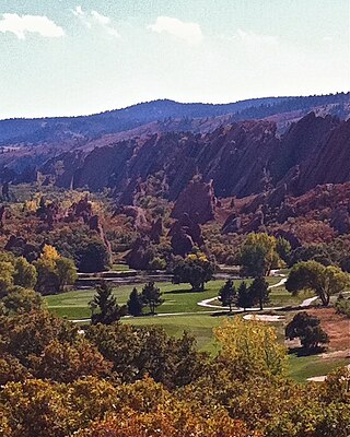
Roxborough Park is an unincorporated community and a census-designated place (CDP) located in and governed by Douglas County, Colorado, United States. The CDP is a part of the Denver–Aurora–Lakewood, CO Metropolitan Statistical Area. The population of the Roxborough Park CDP was 9,416 at the United States Census 2020. The Roxborough Village Metropolitan District and the Roxborough Water and Sanitation District provide services. The Littleton post office serves the area.

The North Platte River is a major tributary of the Platte River and is approximately 716 miles (1,152 km) long, counting its many curves. In a straight line, it travels about 550 miles (890 km), along its course through the U.S. states of Colorado, Wyoming, and Nebraska.

Cherry Creek is a tributary of the South Platte River, 48.0 miles (77.2 km) long, in Colorado in the United States.
Named after Colorado Springs founder William Jackson Palmer, the Palmer Divide is a caprock escarpment-style ridge in central Colorado that separates the Arkansas River basin from the South Platte basin. It extends from the Front Range of the Rockies in central Colorado eastward approximately 80 miles toward the town of Limon. The western end of the Palmer Divide is popularly considered to be at Palmer Lake, located south of Denver and north of Colorado Springs. However, the divide between the two river basins actually extends west and then north to a junction with the Continental Divide at McNamee Peak.

State Highway 470 is a state highway located in the southwestern portion of the Denver Metro Area. It is also the southwestern portion of the Denver Metro area's beltway. SH 470 begins at US 6 in Golden and heads south interchanging Interstate 70 and then US 285 outside Morrison. After leaving Morrison, it then heads east passing by Littleton and through Highlands Ranch before interchanging Interstate 25 in Lone Tree, where the freeway continues as a tollway and where the state highway designation ends.

Douglas County School District Re. 1 is a school district that serves Douglas County, Colorado. The district was formed in 1958 by the consolidation of 17 smaller school districts, adding the "Re. 1" to its name to note the district's first reorganization.

The Rueter–Hess Reservoir, behind the Frank Jaeger Dam, is a major water management project for the Parker Water and Sanitation District PWSD. PWSD provides services for most of Parker and parts of Lone Tree, Castle Pines, and unincorporated Douglas County, Colorado. Originally an enterprise of the Town of Parker, PWSD is now an unaffiliated special District.

Chatfield Dam and Reservoir is a dam and artificial lake located on the South Platte River, south of Littleton, Colorado. The dam and reservoir were built by the United States Army Corps of Engineers as a response to the disastrous flood of 1965. In addition to its primary purpose of flood control, it serves as one of many water supply reservoirs for the city of Denver, Colorado. In 1966, the U.S. Atomic Energy Commission projected a total federal cost of $74 million. Construction of the project was begun in 1967 and the dam was completed in 1975.
State Highway 67 (SH 67) is a 71-mile-long (114 km) state highway encompassing five distinct segments in south-central Colorado. SH 67's southern terminus is at SH 96 in Wetmore, and the northern terminus is at U.S. Route 85 in Sedalia. It traverses the former route of the Florence and Cripple Creek Railroad through Phantom Canyon as a county road and carrying part of the Gold Belt Byway.
Chatfield State Park is a state park located in Douglas and Jefferson counties of Colorado, United States. The park centers on Chatfield Reservoir, a 1,423 acre surface area lake fed by the South Platte River and two other creeks, including Plum Creek.

In the US state of Colorado, Interstate 25 (I-25) follows the north–south corridor through Colorado Springs and Denver. The highway enters the state from the north near Carr and exits the state near Starkville. The highway also runs through the cities of Fort Collins, Broomfield, Loveland, and Pueblo. The route is concurrent with U.S. Route 87 (US 87), which is unsigned, through the entire length of the state. I-25 replaced US 87 and most of US 85 for through traffic.

Athmar Park is a residential neighborhood in southwest Denver, Colorado. It consists mostly of all-brick ranches and bungalow-style homes built in the 1940s and 1950s.

Bayou Gulch is one of the tributaries of Cherry Creek, located mainly in the U.S. state of Colorado. It is part of the Colorado Eastern Plains. An archaeologically sensitive portion of the gulch was listed on the National Register of Historic Places in 2020.
The Sulphur Gulch is one of the tributaries of the Cherry Creek and is located in the U.S. states of Colorado. It is part of the Eastern Plains.
The South Suburban Park and Recreation District is a park and recreation district containing 41 square-miles on the southern edge of the Denver, Colorado metro area. Established in 1959, the park serves around 155,000 people in six communities and three counties: Bow Mar, Columbine Valley, Littleton, Sheridan, Centennial west of 1-25, Lone Tree west of 1-25, and unincorporated portions of Douglas County, Jefferson County and Arapahoe County.
Bear Creek Dam was built on the Bear Creek River, formerly called Grand Encampment as a noteworthy place where multiple Indian tribes gathered, traded, and settled, as reported in an 1816 survey of the area by a French party. The US Army Corps of Engineers built and operates a dam on the confluence of Bear Creek and Turkey Creek within the city limits of Lakewood, Colorado.
Floods in Colorado include the flood of 1844 which filled the South Platte valley from "bluff to bluff" to the recent Denver floods of 1965 and the 2013 Colorado floods.
