Plumb bob

Last updated
A plumb bob Plumb bob.jpg
A plumb bob

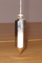
A plumb bob, plumb bob level, or plummet, is a weight, usually with a pointed tip on the bottom, suspended from a string and used as a vertical direction as a reference line, or plumb-line. It is a precursor to the spirit level and used to establish a vertical datum. It is typically made of stone, wood, or lead, but can also be made of other metals. If it is used for decoration, it may be made of bone or ivory.

Contents

The instrument has been used since at least the time of ancient Egypt [1] to ensure that constructions are "plumb", or vertical. It is also used in surveying, to establish the nadir (opposite of zenith) with respect to gravity of a point in space. It is used with a variety of instruments (including levels, theodolites, and steel tapes) to set the instrument exactly over a fixed survey marker or to transcribe positions onto the ground for placing a marker. [2]

Etymology

A plumb rule from Cassells' Carpentry and Joinery Cc&j-fig23--plumb rule.png
A plumb rule from Cassells' Carpentry and Joinery
A plumb square from Cassells' Carpentry and Joinery Cc&j-fig24--plumb square.png
A plumb square from Cassells' Carpentry and Joinery

The plumb in plumb bob derives from Latin plumbum ('lead'), the material once used for the weighted bob at the end. [3] The adjective plumb developed by extension, as did the noun aplomb , from the notion of "standing upright".

Use

Until the modern age, plumb bobs were used on most tall structures to provide vertical datum lines for the building measurements. A section of the scaffolding would hold a plumb line, which was centered over a datum mark on the floor. As the building proceeded upward, the plumb line would also be taken higher, still centered on the datum. Many cathedral spires, domes and towers still have brass datum marks inlaid into their floors, which signify the center of the structure above.

Plumb bob with scale as an inclinometer Lot hg.jpg
Plumb bob with scale as an inclinometer
Plumb bob with string in masonry work Plumb bob with string.jpg
Plumb bob with string in masonry work

A plumb bob and line alone can determine only a vertical reference. However, if they are mounted on a suitable scale the instrument may also be used as an inclinometer to measure angles to the vertical.

Ancient Egyptians used a plumb line attached to the top outer part of a tool resembling a letter E ; when placed against a wall, the plumb line would indicate a vertical line. An A-frame level with a plumb line hung from the vertex was also used to find horizontal; these were used in Europe until the mid–19th century. A variation of this tool has the plumb line hung from the top of an inverted T shape. [3]

The early skyscrapers used heavy plumb bobs, hung on wire in their elevator shafts.[ further explanation needed ]

A plumb bob may be in a container of water (when conditions are above freezing temperatures), molasses, very viscous oils or other liquids to dampen any swinging movement, [4] functioning as a shock absorber.

Determining center of gravity of an irregular shape

Students of figure drawing will also make use of a plumb line to find the vertical axis through the center of gravity of their subject and lay it down on paper as a point of reference. The device used may be purpose-made plumb lines, or simply makeshift devices made from a piece of string and a weighted object, such as a metal washer. This plumb line is important for lining up anatomical geometries and visualizing the subject's center of balance.

See also

Related Research Articles

<span class="mw-page-title-main">Geodesy</span> Science of measuring the shape, orientation, and gravity of the Earth and other astronomical bodies

Geodesy is the science of measuring and representing the geometry, gravity, and spatial orientation of the Earth in temporally varying 3D. It is called planetary geodesy when studying other astronomical bodies, such as planets or circumplanetary systems.

<span class="mw-page-title-main">Physical geodesy</span> Study of the physical properties of the Earths gravity field

Physical geodesy is the study of the physical properties of Earth's gravity and its potential field, with a view to their application in geodesy.

<span class="mw-page-title-main">World Geodetic System</span> Geodetic reference system

The World Geodetic System (WGS) is a standard used in cartography, geodesy, and satellite navigation including GPS. The current version, WGS 84, defines an Earth-centered, Earth-fixed coordinate system and a geodetic datum, and also describes the associated Earth Gravitational Model (EGM) and World Magnetic Model (WMM). The standard is published and maintained by the United States National Geospatial-Intelligence Agency.

<span class="mw-page-title-main">Spirit level</span> Tool to indicate whether a surface is level or plumb

A spirit level, bubble level, or simply a level, is an instrument designed to indicate whether a surface is horizontal (level) or vertical (plumb). Two basic designs exist: tubular and bull's eye . Different types of spirit levels may be used by carpenters, stonemasons, bricklayers, other building trades workers, surveyors, millwrights and other metalworkers, and in some photographic or videographic work.

<span class="mw-page-title-main">Inclinometer</span> Instrument used to measure the inclination of a surface relative to local gravity

An inclinometer or clinometer is an instrument used for measuring angles of slope, elevation, or depression of an object with respect to gravity's direction. It is also known as a tilt indicator, tilt sensor, tilt meter, slope alert, slope gauge, gradient meter, gradiometer, level gauge, level meter, declinometer, and pitch & roll indicator. Clinometers measure both inclines and declines using three different units of measure: degrees, percentage points, and topos. The astrolabe is an example of an inclinometer that was used for celestial navigation and location of astronomical objects from ancient times to the Renaissance.

<span class="mw-page-title-main">Levelling</span> Surveying technique

Levelling or leveling is a branch of surveying, the object of which is to establish or verify or measure the height of specified points relative to a datum. It is widely used in geodesy and cartography to measure vertical position with respect to a vertical datum, and in construction to measure height differences of construction artifacts.

<span class="mw-page-title-main">Steel square</span> Flat tool used in carpentry to mark right angles and calculate angles

The steel square is a tool used in carpentry. Carpenters use various tools to lay out structures that are square, many of which are made of steel, but the name steel square refers to a specific long-armed square that has additional uses for measurement, especially of various angles. It consists of a long, wider arm and a shorter, narrower arm, which meet at an angle of 90 degrees. Today the steel square is more commonly referred to as the framing square or carpenter's square, and such squares are no longer invariably made of steel ; they can also be made of aluminum or polymers, which are light and resistant to rust.

<span class="mw-page-title-main">Benchmark (surveying)</span> Point with known height used in surveying when levelling

The term benchmark, bench mark, or survey benchmark originates from the chiseled horizontal marks that surveyors made in stone structures, into which an angle iron could be placed to form a "bench" for a leveling rod, thus ensuring that a leveling rod could be accurately repositioned in the same place in the future. These marks were usually indicated with a chiseled arrow below the horizontal line. A benchmark is a type of survey marker.

<span class="mw-page-title-main">Tribrach (instrument)</span> Adjustable mounting plate between a surveying instrument and its tripod

A tribrach is an attachment plate used to attach a surveying instrument, for example a theodolite, total station, GNSS antenna or target to a tripod. A tribrach allows the survey instrument to be repeatedly placed in the same position over a surveying marker point with sub-millimetre precision, by loosening and re-tightening a lock to adjust the instrument base in a horizontal plane.

The orthometric height is the vertical distance H along the plumb line from a point of interest to a reference surface known as the geoid, the vertical datum that approximates mean sea level. Orthometric height is one of the scientific formalizations of a laypersons' "height above sea level", along with other types of heights in Geodesy.

<span class="mw-page-title-main">Aqua Virgo</span> Ancient Roman aqueduct in Italy

The Aqua Virgo was one of the eleven Roman aqueducts that supplied the city of ancient Rome. It was completed in 19 BC by Marcus Agrippa, during the reign of the emperor Augustus and was built mainly to supply the contemporaneous Baths of Agrippa in the Campus Martius.

<span class="mw-page-title-main">Groma (surveying)</span> Principal Roman surveying instrument

The groma was a surveying instrument used in the Roman Empire. The groma allowed projecting right angles and straight lines and thus enabling the centuriation. It is the only Roman surveying tool with examples that made it through to the present day.

<span class="mw-page-title-main">North American Vertical Datum of 1988</span> Vertical datum for orthometric heights

The North American Vertical Datum of 1988 is the vertical datum for orthometric heights established for vertical control surveying in the United States of America based upon the General Adjustment of the North American Datum of 1988.

The Hand drill is a hieroglyph,, used in ancient Egypt from the earliest dynasties. As a hieroglyph, it can also be used as a determinative for words related to the profession of vase, bowl, pot-making, etc., typically from fine-grained, colorful rare stone, for example unguent jars. The size of drills was small-to-large, small for small unguent jars, and large for more massive, grain-storing pottery. The original jars found in tombs were more often used for ceremonial usages, presumably the reason they are found as grave goods or tomb offerings.

<span class="mw-page-title-main">Chalk line</span> Tool for marking straight lines

A chalk line or chalk box is a tool for marking long, straight lines on relatively flat surfaces, much farther than is practical by hand or with a straightedge. They may be used to lay out straight lines between two points, or vertical lines by using the weight of the line reel as a plumb line.

Construction surveying or building surveying is to provide dimensional control for all stages of construction work, including the stake out of reference points and markers that will guide the construction of new structures such as roads, rail, or buildings. These markers are usually staked out according to a suitable coordinate system selected for the project.

In astronomy, geography, and related sciences and contexts, a direction or plane passing by a given point is said to be vertical if it contains the local gravity direction at that point.

This is a glossary of levelling terms. Levelling is a surveying method used to find relative height, one use of which is to ensure ground is level during construction, for example, when excavating to prepare for laying a foundation for a house.

<span class="mw-page-title-main">String (structure)</span> Flexible structure made from fibers twisted together

String is a long flexible structure made from fibers twisted together into a single strand, or from multiple such strands which are in turn twisted together. String is used to tie, bind, or hang other objects. It is also used as a material to make things, such as textiles, and in arts and crafts. String is a simple tool, and its use by humans is known to have been developed tens of thousands of years ago. In Mesoamerica, for example, string was invented some 20,000 to 30,000 years ago, and was made by twisting plant fibers together. String may also be a component in other tools, and in devices as diverse as weapons, musical instruments, and toys.

Vertical position or vertical location is a position along a vertical direction above or below a given vertical datum . Vertical distance or vertical separation is the distance between two vertical positions. Many vertical coordinates exist for expressing vertical position: depth, height, altitude, elevation, etc. Points lying on an equigeopotential surface are said to be on the same vertical level, as in a water level.

References

  1. Denys A. Stocks. Experiments in Egyptian archaeology: stoneworking technology in Ancient Egypt . Routledge; 2003. ISBN   978-0-415-30664-5. p. 180.
  2. Brinker, Russell Charles; Minnick, Roy, eds. (1995). The surveying handbook . Springer. pp.  93–94. ISBN   978-0-412-98511-9.
  3. 1 2 McGeough, Joseph A.; Hartenberg, Richard S. (2019). "Hand tool | Measuring and defining tools | Plumb line, level, and square". Encyclopaedia Britannica.
  4. Staley, W. W.. Introduction to mine surveying,. 2nd ed. Stanford University, Calif.: Stanford University Press, 1964. Print. 138.