Plymouth, Montserrat

Last updated

Plymouth
Plymouth Montserrat Heli.jpg
Plymouth in 2006, following the 1997 eruptions which buried most of the town in ash
Nickname: 
The Emerald Isle of the Caribbean
Motto(s): 
"A people of excellence, moulded by nature, nurtured by God. [1] "
Montserrat location map.svg
Red pog.svg
Plymouth
Location of Plymouth within Montserrat
Caribbean location map.svg
Red pog.svg
Plymouth
Plymouth (Caribbean)
Coordinates: 16°42′23″N62°12′57″W / 16.706417°N 62.215839°W / 16.706417; -62.215839
CountryFlag of the United Kingdom.svg  United Kingdom
Overseas territory Flag of Montserrat.svg  Montserrat
Population
 (2016)
  Total0
 4,000 inhabitants before evacuation as a result of volcanic eruption
Time zone UTC-4 (Atlantic)

Plymouth is a ghost town and the de jure capital of the island of Montserrat, an overseas territory of the United Kingdom located in the Leeward Island chain of the Lesser Antilles, West Indies. It is the only ghost town that is the capital of a modern political territory.

Contents

Constructed on historical lava deposits near the then long inactive Soufrière Hills volcano, the town was evacuated in 1995 when the volcano resumed erupting. Plymouth was eventually abandoned permanently in 1997 [2] after it was substantially buried by a series of pyroclastic flows and lahars. For centuries, it had been the only port of entry to the island. Plymouth is still the de jure capital of Montserrat, making it the only ghost town that is the capital of a political territory. A new capital is under construction at Little Bay, [3] with nearby Brades serving as the de facto capital for the time being.

History

St. Anthony's Church

After the establishment of the first European colony on the island of Montserrat in 1632, St. Anthony's Church was established in Plymouth in 1636. [4] Although there is a St. Anthony in Catholicism, it is believed that Governor Anthony Brisket, who went to England to secure funds to build the church, had the church named after himself. [5] The church had to be rebuilt several times throughout its history due to damage from earthquakes and hurricanes. As of September 2021, the church is buried deep in the ash.

Hurricane Hugo

Montserrat was struck by Hurricane Hugo on 17 September 1989. The hurricane destroyed a 180-foot stone jetty in Plymouth's harbour. [6] Many other buildings, including schools, health centres, and the recently constructed central hospital building, were rendered unusable by damage from the storm. Given that the hospital was the only one on the island, and damages were extensive enough that all patients had to be relocated, a survey conducted by engineers from the National Emergency Management Agency of Trinidad and Tobago concluded that the hospital should undergo substantial redesign in order to ensure its structural strength could withstand future storms. [7]

Volcanic eruptions and abandonment

By 12 July 1997, pyroclastic flows had burned much of what had not already been covered in ash Montserrat eruption.JPG
By 12 July 1997, pyroclastic flows had burned much of what had not already been covered in ash
Ash piled as high as a streetlamp on the streets of Plymouth (1999) Montserrat Plymouth Street Lamp.png
Ash piled as high as a streetlamp on the streets of Plymouth (1999)

Beginning on 18 July 1995, a series of huge eruptions at the Soufrière Hills volcano, which had been inactive for centuries, sent ash falls across a wide area of southern Montserrat including the capital, Plymouth. It was soon clear that the town was in grave danger. On 21 August 1995, tephra fell on Plymouth, necessitating an evacuation that lasted until 3 September 1995. Following renewed volcanic activity, on 1 December 1995 residents were evacuated for the second time. This evacuation lasted for one month before residents were allowed back on 1 January 1996. [8]

On 27 March 1996, a series of hot ash emissions and pyroclastic flows began, [9] marking the most dangerous period for the volcano up to that point. Areas nearest the volcano were immediately evacuated; as the volcanic activity continued to escalate, on 3 April 1996, Plymouth was evacuated for the third and final time. [10] The island was divided into risk zones; during some periods, entry into Plymouth was prohibited, [11] and at other times, it was allowed during daytime only to those with a means of rapid escape. [12] The last time that access was legally allowed to Plymouth during daytime was 16 June 1997, with the exception of essential services. [13] [14] On 25 June 1997, a further massive eruption produced pyroclastic surges that killed 19 people and reached nearly to the island's airport on the eastern side of the island, which had remained open until that time. [15] [16]

Between 4–8 August 1997, a further series of large eruptions destroyed approximately 80% of the town, burying it under 1.4 metres (4.6 ft) of ash. This hot material burned many of the buildings, making habitation nearly impossible for many of the residents.

The pyroclastic flows, lava, ash and other volcanic rock types were mostly compact, having a density similar to that of concrete. The removal of the overburden would have required the use of explosives, bulldozers and other resources too expensive for widespread use. It was anticipated that the soil underneath the hardened mud and lava would have been scorched and left completely non-arable by the intense heat of the pyroclastic flows.

The government ordered the evacuation of Plymouth, with the Royal Navy assisting by taking the population to safety. The entire southern half of the island was declared an exclusion zone because of the continuing volcanic activity at the Soufrière Hills. The government of the island was moved north to the town of Brades, although Plymouth remains the de jure capital. As of 2013, a new port and capital are under construction at Little Bay, on the island's northwest coast. Daytime access to Plymouth has been permitted for some activities since about 2015, including sand and gravel extraction for construction projects. [17]

The total destruction of Plymouth caused severe economic problems for the island of Montserrat. Plymouth had been by far the largest settlement on the island, with a population of around 4,000 inhabitants, and as such had been the site of almost all the island's shops and services, in addition to having been its seat of government. Some of the lost facilities were subsequently rebuilt elsewhere on Montserrat, but this did not prevent emigration. Between 1995 and 2000, two-thirds of the island's total population was forced to flee, many of whom settled in the United Kingdom, leaving fewer than 1,200 people resident on the island as of 1997. The population figure had risen to nearly 5,000 by 2016.[ citation needed ]

Geography

Plymouth in 2012, showing the revegetation of the zone buried by ash Montserrat, Karibik - 2012-03-04 - Plymouth - Soufriere Hills - panoramio.jpg
Plymouth in 2012, showing the revegetation of the zone buried by ash

Plymouth is situated on the lower southwest slope of the Soufrière Hills Volcano. It is well within the volcanic exclusion zone, which is considered wholly uninhabitable.

Climate

Climate data for Plymouth
MonthJanFebMarAprMayJunJulAugSepOctNovDecYear
Record high °C (°F)32
(90)
33
(91)
34
(93)
34
(93)
36
(97)
37
(99)
37
(99)
37
(99)
36
(97)
34
(93)
37
(99)
33
(91)
37
(99)
Mean daily maximum °C (°F)29
(84)
30
(86)
31
(88)
31
(88)
32
(90)
32
(90)
33
(91)
33
(91)
32
(90)
31
(88)
30
(86)
29
(84)
31
(88)
Mean daily minimum °C (°F)23
(73)
23
(73)
24
(75)
24
(75)
24
(75)
25
(77)
25
(77)
25
(77)
24
(75)
24
(75)
24
(75)
23
(73)
24
(75)
Record low °C (°F)17
(63)
18
(64)
18
(64)
18
(64)
19
(66)
21
(70)
22
(72)
22
(72)
21
(70)
19
(66)
19
(66)
18
(64)
17
(63)
Average precipitation mm (inches)122
(4.8)
86
(3.4)
112
(4.4)
89
(3.5)
97
(3.8)
112
(4.4)
155
(6.1)
183
(7.2)
168
(6.6)
196
(7.7)
180
(7.1)
140
(5.5)
1,640
(64.6)
Source: BBC Weather [18]

Transport

The airport serving the island of Montserrat, W. H. Bramble Airport, was shut down completely by 1997 and subsequently destroyed as it was buried in volcanic ash. A new airport, John A. Osborne Airport, opened in 2005 at Gerald's, near Brades in the north of the island. [19]

Education

In the pre-1997 period it was served by Plymouth Primary School, [20] and Plymouth Junior Secondary School. [21]

Notable people

See also

Related Research Articles

<span class="mw-page-title-main">Montserrat</span> British Overseas Territory in the Caribbean

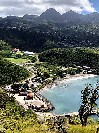
Montserrat is a British Overseas Territory in the Caribbean. It is part of the Leeward Islands, the northern portion of the Lesser Antilles chain of the West Indies. Montserrat is about 16 km (10 mi) long and 11 km (7 mi) wide, with roughly 40 km (25 mi) of coastline. It is nicknamed "The Emerald Isle of the Caribbean" both for its resemblance to coastal Ireland and for the Irish ancestry of many of its inhabitants. Montserrat is the only non-fully sovereign full member of the Caribbean Community and the Organisation of Eastern Caribbean States.

<span class="mw-page-title-main">Geography of Montserrat</span>

Montserrat is an island in the Caribbean Sea, in the Leeward Islands. Its nearest neighbours in the island chain include Guadeloupe to the southeast, Antigua to the north-east and Nevis to the northwest. The island is 16 km (9.9 mi) long and 11 km (6.8 mi) wide, with a coastline of about 40 km.

<span class="mw-page-title-main">Economy of Montserrat</span>

The economy of Montserrat was severely disrupted by volcanic activity which began in July 1995. Prior to this date, the small island country of 12,000 had an export economy based on agriculture, clothing, electronic parts and plants, with a per capita gross national product of US$3,000 to 8,000.

<span class="mw-page-title-main">Pyroclastic flow</span> Fast-moving current of hot gas and volcanic matter that moves away from a volcano

A pyroclastic flow is a fast-moving current of hot gas and volcanic matter that flows along the ground away from a volcano at average speeds of 100 km/h but is capable of reaching speeds up to 700 km/h. The gases and tephra can reach temperatures of about 1,000 °C (1,800 °F).

<span class="mw-page-title-main">Mount Pelée</span> Active volcano on the Caribbean island of Martinique

Mount Pelée or Mont Pelée is an active volcano at the northern end of Martinique, an island and French overseas department in the Lesser Antilles Volcanic Arc of the Caribbean. Its volcanic cone is composed of stratified layers of hardened ash and solidified lava. Its most recent eruption was in 1932.

<span class="mw-page-title-main">Mount Unzen</span> Group of volcanoes in Nagasaki Prefecture, Japan

Mount Unzen is an active volcanic group of several overlapping stratovolcanoes, near the city of Shimabara, Nagasaki on the island of Kyushu, Japan's southernmost main island.

<span class="mw-page-title-main">Soufrière Hills</span> Volcano on Montserrat in the Caribbean

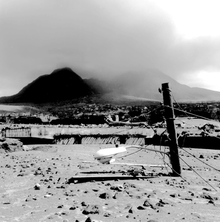
The Soufrière Hills are an active, complex stratovolcano with many lava domes forming its summit on the Caribbean island of Montserrat. After a long period of dormancy, the Soufrière Hills volcano became active in 1995 and has continued to erupt ever since. Its eruptions have rendered more than half of Montserrat uninhabitable, destroying the capital city, Plymouth, and causing widespread evacuations: about two-thirds of the population have left the island. Chances Peak in the Soufrière Hills was the highest summit on Montserrat until the mid-1990s, but it has since been eclipsed by various rising and falling volcanic domes during the recent volcanic activity.

<span class="mw-page-title-main">Lava dome</span> Roughly circular protrusion from slowly extruded viscous volcanic lava

In volcanology, a lava dome is a circular, mound-shaped protrusion resulting from the slow extrusion of viscous lava from a volcano. Dome-building eruptions are common, particularly in convergent plate boundary settings. Around 6% of eruptions on Earth are lava dome forming. The geochemistry of lava domes can vary from basalt to rhyolite although the majority are of intermediate composition The characteristic dome shape is attributed to high viscosity that prevents the lava from flowing very far. This high viscosity can be obtained in two ways: by high levels of silica in the magma, or by degassing of fluid magma. Since viscous basaltic and andesitic domes weather fast and easily break apart by further input of fluid lava, most of the preserved domes have high silica content and consist of rhyolite or dacite.

<span class="mw-page-title-main">Cerro Negro</span> Active volcano in Nicaragua

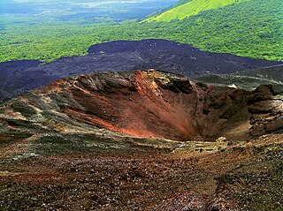
Cerro Negro is an active volcano in the Cordillera de los Maribios mountain range in Nicaragua, about 10 km (6.2 mi) from the village of Malpaisillo. It is a very new volcano, the youngest in Central America, having first appeared in April 1850. It consists of a gravelly basaltic cinder cone, which contrasts greatly with the surrounding verdant hillsides, and gives rise to its name, which means Black Hill. Cerro Negro has erupted frequently since its first eruption. One unusual aspect of several eruptions has been the emission of ash from the top of the cone, while lava erupts from fractures at the base.

<span class="mw-page-title-main">La Soufrière (Saint Vincent)</span> Active stratovolcano on the Caribbean island Saint Vincent

La Soufrière or Soufrière Saint Vincent is an active volcano on the Caribbean island of Saint Vincent in Saint Vincent and the Grenadines. It is the highest peak on Saint Vincent, and has had eight recorded eruptions since 1718. The latest eruptive activity began on 27 December 2020 with the slow extrusion of a dome of lava, and culminated in a series of explosive events between 9 and 22 April 2021.

<span class="mw-page-title-main">Vulcanian eruption</span> Volcanic eruption with dense ash clouds

A Vulcanian eruption is a type of volcanic eruption characterized by a dense cloud of ash-laden gas exploding from the crater and rising high above the peak. They usually commence with phreatomagmatic eruptions which can be extremely noisy due to the rising magma heating water in the ground. This is usually followed by the explosive clearing of the vent and the eruption column is dirty grey to black as old weathered rocks are blasted out of the vent. As the vent clears, further ash clouds become grey-white and creamy in colour, with convolutions of the ash similar to those of Plinian eruptions.

<span class="mw-page-title-main">Brades</span> De facto capital of Montserrat

Brades is a town and the de facto capital of Montserrat since 1998 with an approximate population of 1,000.

<span class="mw-page-title-main">W. H. Bramble Airport</span> Former international airport on the island of Montserrat

W.H. Bramble Airport, formerly known as Blackburne Airport, was an international airport on the east coast of the island of Montserrat, a British Overseas Territory in the Caribbean. It was named after Montserrat Chief Minister William Henry Bramble.

Radio Antilles was a radio station operated by the Antilles Radio Corporation which began broadcasting in 1963. It was located on the British Caribbean island of Montserrat.

<span class="mw-page-title-main">Outline of Montserrat</span> Overview of and topical guide to Montserrat

The following outline is provided as an overview of and topical guide to Montserrat:

<i>Music for Montserrat</i> 1998 live album by Various Artists

Music for Montserrat was a benefit concert held on 15 September 1997 at the Royal Albert Hall. The event was organised by Sir George Martin, former producer for The Beatles and founder of Associated Independent Recording, to raise funds for the Caribbean island of Montserrat after a major volcanic eruption by the Soufrière Hills volcano earlier that year.

<span class="mw-page-title-main">Little Bay, Montserrat</span> Town in Montserrat, United Kingdom

Little Bay is a port town under construction which is intended to be the future capital of the island of Montserrat, a British Overseas Territory in the Caribbean. It is adjacent to the town of Brades, where government headquarters are currently located.

<span class="mw-page-title-main">2018 Volcán de Fuego eruption</span> Volcanic eruption in Guatemala

The 2018 Volcán de Fuego eruption was an eruption of Volcán de Fuego in Guatemala on Sunday 3 June 2018. The eruption produced a large ash plume fed by continuous explosions, pyroclastic flows, and lahars. Pyroclastic flows descended the Las Lajas ravine and overspilled its confines, causing the death of officially nearly 200 people. This was the deadliest eruption in Guatemala since the eruption of Volcán Santiaguito in 1902.

<span class="mw-page-title-main">2021 eruption of La Soufrière</span> Volcanic eruption in the Caribbean

La Soufrière, a stratovolcano on the Caribbean island of Saint Vincent in Saint Vincent and the Grenadines, began an effusive eruption on 27 December 2020. On 9 April 2021 there was an explosive eruption, and the volcano "continued to erupt explosively" over the following days, with pyroclastic flows. The activity pattern of the eruption was comparable to that of the event that occurred in 1902, which had a Volcanic Explosivity Index (VEI) of 4. The volcano is known to have erupted 23 times in the last 4,000 years, and had been dormant since 1979.

<span class="mw-page-title-main">1951 eruption of Mount Lamington</span> Volcanic eruption in the Territory of Papua and New Guinea

In early January 1951, a series of minor explosions and earthquakes rocked Mount Lamington, a volcano in Oro Province, Territory of Papua and New Guinea. Prior to the eruption, Mount Lamington was not recognized as a volcano due to the absence of historically-recorded eruptions and dense vegetation cover. From January 15, volcanic activity intensified, and tall eruption plumes were generated. The largest eruption occurred on the morning of January 21 when a thick black plume of ash rose 15,000 metres (50,000 ft) into the atmosphere. The eruption collapsed a lava dome and produced a lethal pyroclastic flow that killed 2,942 people. In the years after the eruption, new lava domes formed and collapsed in succession. Activity persisted until July 1956. The eruption is the deadliest natural disaster in Australian history, as the region was under the rule of the Government of Australia.

References

  1. "Government of Montserrat website".
  2. "Montserrat (Hansard, 5 November 1997)". api.parliament.uk.
  3. "Montserrat Port Development Project: Governor Sarah Tucker's remarks". GOV.UK. 21 June 2022.
  4. "Montserrat's Archaeology and History" Retrieved 12 October 2019
  5. "Montserrat History" Retrieved 12 October 2019
  6. "Montserrat History" Retrieved 13 October 2019
  7. "Hurricane Hugo; A Survey of Damage in Montserrat and Antigua" [ permanent dead link ] M.W. Chin & W.H.E. Suite, National Emergency Management Agency of Trinidad and Tobago. 19 February 1990.
  8. "Gov't of Montserrat Information Service - Press Releases".
  9. "Report on Soufrière Hills (United Kingdom)". Bulletin of the Global Volcanism Network. 21 (3). 1996. doi:10.5479/si.GVP.BGVN199603-360050.
  10. "Gov't of Montserrat Information Service - Press Releases".
  11. "Gov't of Montserrat Information Service - the Volcanic Explanation".
  12. "Gov't of Montserrat Information Service - the Volcanic Explanation".
  13. "Government of Montserrat, Soufriere Hills Notice 1997167_1".
  14. "Government of Montserrat, Soufriere Hills Notice 1997168_1".
  15. "Gov't of Montserrat Information Service - the Volcanic Explanation".
  16. "Montserrat Volcano Observatory, Special Report 03".
  17. "'Ash to cash': Montserrat gambles future on the volcano that nearly destroyed it". the Guardian. 28 January 2016.
  18. "Average Conditions Plymouth, Montserrat". BBC Weather. Archived from the original on 30 November 2010. Retrieved 14 July 2010.
  19. "From the Ashes: Rebuilding Montserrat". 29 August 2016.
  20. Thomas, Emel (editor). Education in the Commonwealth Caribbean and Netherlands Antilles. Bloomsbury Publishing, 8 May 2014. ISBN   1623563836, 9781623563837. p. 279.
  21. "Report of the Technical-Vocational Education and Training Reconnaissance Mission." UNESCO. Annex 1 p. 2 (PDF p. 12/14). Retrieved on 27 November 2017.