
A broch is an Iron Age drystone hollow-walled structure found in Scotland. Brochs belong to the classification "complex Atlantic roundhouse" devised by Scottish archaeologists in the 1980s. Their origin is a matter of some controversy.

The Brough of Birsay is an uninhabited tidal island off the north-west coast of The Mainland of Orkney, Scotland, in the parish of Birsay. It is located around 13 miles north of Stromness and features the remains of Pictish and Norse settlements as well as a modern light house.

The Mainland, also known as Hrossey and Pomona, is the main island of Orkney, Scotland. Both of Orkney's burghs, Kirkwall and Stromness, lie on the island, which is also the heart of Orkney's ferry and air connections.
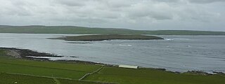
Eynhallow is a small, presently uninhabited island, part of Orkney, off the north coast of mainland Scotland.
Birsay is a parish in the north west corner of The Mainland of Orkney, Scotland. Almost all the land in the parish is devoted to agriculture: chiefly grassland used to rear beef cattle. There are various ancient monuments in the parish.

Evie is a parish and village on Mainland, Orkney, Scotland. The parish is located in the north-west of the Mainland, between Birsay and Rendall, forming the coastline opposite the isle of Rousay.

The Burn of Ayreland is a northwesterly flowing coastal stream on Mainland Orkney, Scotland, that discharges to the Clestrain Sound about two miles south of Stenness. Draining chiefly agricultural lands elevated mosses and moorland. This stream has a notable lack of turbidity and a pH level of approximately 8. Armouring of the stream bottom consists of pebbles, cobbles and occasional boulders.

Mor Stein is a neolithic standing stone in the southeastern part of the island of Shapinsay, Orkney Islands, Scotland. Shapinsay is one of the two large inner islands of the Orkney group, and it is situated approximately two miles north of the Orkney Mainland. Linton Bay is situated slightly to the northeast of Mor Stein.
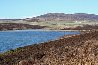
Waulkmill Bay is a tidal bay on the southwest of Mainland Orkney, Scotland. This bay and its immediately surrounding area have been identified as a Site of Special Scientific Interest by Scottish Natural Heritage.

The Bay of Linton is a bay on the east coast on the island of Shapinsay in the Orkney Islands, Scotland. To the north of Linton Bay are the headlands of Ness of Ork, and to the south is The Foot. The ancient monument the Broch of Burroughston is slightly north of Linton Bay.

Castle Bloody is a prehistoric feature on the island of Shapinsay, Orkney, Scotland. Hogan observes that while the feature is marked as a chambered mound on the UK Ordnance Survey map, the structure is more properly and specifically classified as a souterrain or earth house. Slightly to the north is located the ruined historic Linton Chapel.

Linton Chapel is a ruined chapel on the east coast of Shapinsay, Orkney. The chapel is thought to date as early as the 12th century AD. Slightly to the south is a megalithic monument, Castle Bloody.
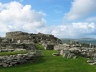
The Broch of Gurness is an Iron Age broch village on the northeast coast of Mainland Orkney in Scotland overlooking Eynhallow Sound, about 15 miles north-west of Kirkwall. It once housed a substantial community.

Eynhallow Sound is a seaway lying between Mainland Orkney and the island of Rousay in the Orkney Islands, Scotland. The tidal indraught is "scarcely felt beyond a line joining Costa Head and the Reef of Quendale". An Iron Age broch, Gurness, has a strategic outlook over the Eynhallow Sound.
The Sands of Evie is a sandy beach landform near the village of Evie on Mainland Orkney, Scotland, protected by the Point of Hellia headland. This beach forms the southern boundary of Aikerness Bay, an element of Eynhallow Sound. Immediately to the east is Gurness, a rather well preserved Iron Age broch. A Pictish slab was discovered on the Sands of Evie in 1967 and is now housed in Orkney Museum.
Aikerness Bay is an embayment of Eynhallow Sound on the northwest coast of Mainland Orkney, Scotland. The headlands of Point of Hellia at the east and Grit Ness at the west form the limit points of Aikerness Bay. The beach along the southern boundary of Aikerness Bay is known as the Sands of Evie. At the eastern end of Aikerness Bay is Gurness, an Iron Age broch.
Costa Head is a prominent headland on Eynhallow Sound on the northwestern coast of the Orkney Mainland, Scotland. The tidal indraught of Eynhallow Sound is "scarcely felt beyond a line joining Costa Head and the Reef of Quendale". To the east is the Point of Hellia on which is located the Broch of Gurness, an Iron Age promontory fort. Gurness' drystone construction of the "round tower fort is flanked by a number of ancillary structures and impressive concentric ditch and rampart outer defences; moreover, the rocky shoreline cliffs posed a formidable approach for marine invaders."

Rendall is a parish on Mainland, Orkney, Scotland. It is in the north west of the island and lies east of the parishes of Birsay and Evie and north east of Harray. The island of Gairsay is also in the parish.

Sandwick is a parish on the west coast of Mainland, Orkney, Scotland, 4 miles (6.4 km) north of Stromness.

Holm of Grimbister is an inhabited tidal islet in the Orkney archipelago of Scotland. Located in the Bay of Firth near Finstown it is connected to Mainland Orkney by a causeway.
