
In physical geography, tundra is a type of biome where tree growth is hindered by frigid temperatures and short growing seasons. The term tundra comes through Russian тундра from the Kildin Sámi word тӯндар meaning "uplands", "treeless mountain tract". There are three regions and associated types of tundra: Arctic tundra, alpine tundra, and Antarctic tundra.

The cryosphere is an all-encompassing term for the portions of Earth's surface where water is in solid form, including sea ice, lake ice, river ice, snow cover, glaciers, ice caps, ice sheets, and frozen ground. Thus, there is a wide overlap with the hydrosphere. The cryosphere is an integral part of the global climate system with important linkages and feedbacks generated through its influence on surface energy and moisture fluxes, clouds, precipitation, hydrology, atmospheric and oceanic circulation.

Methane clathrate (CH4·5.75H2O) or (8CH4·46H2O), also called methane hydrate, hydromethane, methane ice, fire ice, natural gas hydrate, or gas hydrate, is a solid clathrate compound (more specifically, a clathrate hydrate) in which a large amount of methane is trapped within a crystal structure of water, forming a solid similar to ice. Originally thought to occur only in the outer regions of the Solar System, where temperatures are low and water ice is common, significant deposits of methane clathrate have been found under sediments on the ocean floors of the Earth. Methane hydrate is formed when hydrogen-bonded water and methane gas come into contact at high pressures and low temperatures in oceans.
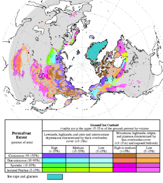
Permafrost is soil or underwater sediment which continuously remains below 0 °C (32 °F) for two years or more: the oldest permafrost had been continuously frozen for around 700,000 years. While the shallowest permafrost has a vertical extent of below a meter, the deepest is greater than 1,500 m (4,900 ft). Similarly, the area of individual permafrost zones may be limited to narrow mountain summits or extend across vast Arctic regions. The ground beneath glaciers and ice sheets is not usually defined as permafrost, so on land, permafrost is generally located beneath a so-called active layer of soil which freezes and thaws depending on the season.
This glossary of climate change is a list of definitions of terms and concepts relevant to climate change, global warming, and related topics.

This is a list of meteorology topics. The terms relate to meteorology, the interdisciplinary scientific study of the atmosphere that focuses on weather processes and forecasting.

The climate of Mars has been a topic of scientific curiosity for centuries, in part because it is the only terrestrial planet whose surface can be directly observed in detail from the Earth with help from a telescope.
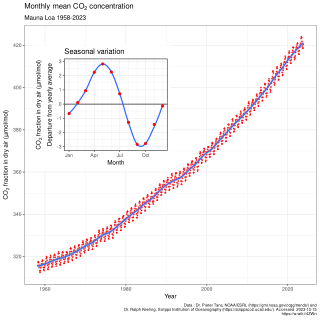
In Earth's atmosphere, carbon dioxide is a trace gas that plays an integral part in the greenhouse effect, carbon cycle, photosynthesis and oceanic carbon cycle. It is one of several greenhouse gases in the atmosphere of Earth. The current global average concentration of CO2 in the atmosphere is 421 ppm as of May 2022 (0.04%). This is an increase of 50% since the start of the Industrial Revolution, up from 280 ppm during the 10,000 years prior to the mid-18th century. The increase is due to human activity. Burning fossil fuels is the main cause of these increased CO2 concentrations and also the main cause of climate change. Other large anthropogenic sources include cement production, deforestation, and biomass burning.

Ocean heat content (OHC) is the energy absorbed and stored by oceans. To calculate the ocean heat content, it is necessary to measure ocean temperature at many different locations and depths. Integrating the areal density of ocean heat over an ocean basin or entire ocean gives the total ocean heat content. Between 1971 and 2018, the rise in ocean heat content accounted for over 90% of Earth’s excess thermal energy from global heating. The main driver of this increase was anthropogenic forcing via rising greenhouse gas emissions. By 2020, about one third of the added energy had propagated to depths below 700 meters. In 2022, the world’s oceans were again the hottest in the historical record and exceeded the previous 2021 record maximum. The four highest ocean heat observations occurred in the period 2019–2022. The North Pacific, North Atlantic, the Mediterranean, and the Southern Ocean all recorded their highest heat observations for more than sixty years. Ocean heat content and sea level rise are important indicators of climate change.

Major environmental issues caused by contemporary climate change in the Arctic region range from the well-known, such as the loss of sea ice or melting of the Greenland ice sheet, to more obscure, but deeply significant issues, such as permafrost thaw, as well as related social consequences for locals and the geopolitical ramifications of these changes. The Arctic is likely to be especially affected by climate change because of the high projected rate of regional warming and associated impacts. Temperature projections for the Arctic region were assessed in 2007: These suggested already averaged warming of about 2 °C to 9 °C by the year 2100. The range reflects different projections made by different climate models, run with different forcing scenarios. Radiative forcing is a measure of the effect of natural and human activities on the climate. Different forcing scenarios reflect things such as different projections of future human greenhouse gas emissions.
This is a list of climate change topics.

Arctic methane release is the release of methane from seas and soils in permafrost regions of the Arctic. While it is a long-term natural process, methane release is exacerbated by global warming. This results in a positive feedback cycle, as methane is itself a powerful greenhouse gas.

Arctic geoengineering is a type of climate engineering in which polar climate systems are intentionally manipulated to reduce the undesired impacts of climate change. As a proposed solution to climate change, arctic geoengineering is relatively new and has not been implemented on a large scale. It is based on the principle that Arctic albedo plays a significant role in regulating the Earth's temperature and that there are large-scale engineering solutions that can help maintain Earth's hemispheric albedo. According to researchers, projections of sea ice loss, when adjusted to account for recent rapid Arctic shrinkage, indicate that the Arctic will likely be free of summer sea ice sometime between 2059 and 2078. Advocates for Arctic geoengineering believe that climate engineering methods can be used to prevent this from happening.
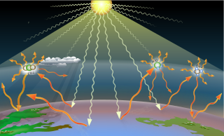
Greenhouse gases are the gases in the atmosphere that raise the surface temperature of planets such as the Earth. What distinguishes them from other gases is that they absorb the wavelengths of radiation that a planet emits, resulting in the greenhouse effect. The Earth is warmed by sunlight, causing its surface to radiate heat, which is then mostly absorbed by water vapor (H2O), carbon dioxide (CO2), methane (CH4), nitrous oxide (N2O), and ozone (O3). Without greenhouse gases, the average temperature of Earth's surface would be about −18 °C (0 °F), rather than the present average of 15 °C (59 °F).

Climate change feedbacks are effects of global warming that amplify or diminish the effect of forces that initially cause the warming. Positive feedbacks enhance global warming while negative feedbacks weaken it. Feedbacks are important in the understanding of climate change because they play an important part in determining the sensitivity of the climate to warming forces. Climate forcings and feedbacks together determine how much and how fast the climate changes. Large positive feedbacks can lead to tipping points—abrupt or irreversible changes in the climate system—depending upon the rate and magnitude of the climate change.

The permafrost carbon cycle or Arctic carbon cycle is a sub-cycle of the larger global carbon cycle. Permafrost is defined as subsurface material that remains below 0o C for at least two consecutive years. Because permafrost soils remain frozen for long periods of time, they store large amounts of carbon and other nutrients within their frozen framework during that time. Permafrost represents a large carbon reservoir, one which was often neglected in the initial research determining global terrestrial carbon reservoirs. Since the start of 2000s, however, far more attention has been paid to the subject, with an enormous growth both in general attention and in the scientific research output.

There are many effects of climate change on oceans. One of the main ones is an increase in ocean temperatures. More frequent marine heatwaves are linked to this. The rising temperature contributes to a rise in sea levels. Other effects include ocean acidification, sea ice decline, increased ocean stratification and reductions in oxygen levels. Changes to ocean currents including a weakening of the Atlantic meridional overturning circulation are another important effect. All these changes have knock-on effects which disturb marine ecosystems. The main cause of these changes is climate change due to human emissions of greenhouse gases. Carbon dioxide and methane are examples of greenhouse gases. This leads to ocean warming, because the ocean takes up most of the additional heat in the climate system. The ocean absorbs some of the extra carbon dioxide in the atmosphere. This causes the pH value of the ocean to drop. Scientists estimate that the ocean absorbs about 25% of all human-caused CO2 emissions.

In earth science, global surface temperature is calculated by averaging the temperatures over sea and land. Periods of global cooling and global warming have alternated throughout Earth's history.
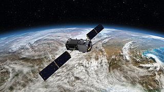
Space-based measurements of carbon dioxide are used to help answer questions about Earth's carbon cycle. There are a variety of active and planned instruments for measuring carbon dioxide in Earth's atmosphere from space. The first satellite mission designed to measure CO2 was the Interferometric Monitor for Greenhouse Gases (IMG) on board the ADEOS I satellite in 1996. This mission lasted less than a year. Since then, additional space-based measurements have begun, including those from two high-precision satellites. Different instrument designs may reflect different primary missions.
Increasing methane emissions are a major contributor to the rising concentration of greenhouse gases in Earth's atmosphere, and are responsible for up to one-third of near-term global heating. During 2019, about 60% of methane released globally was from human activities, while natural sources contributed about 40%. Reducing methane emissions by capturing and utilizing the gas can produce simultaneous environmental and economic benefits.