Pollocksville, North Carolina

Last updated

Pollocksville, North Carolina
Town of Pollocksville
Pollocksville, North Carolina 01.jpg
Downtown Pollocksville
NCMap-doton-Pollocksville.PNG
Location of Pollocksville, North Carolina
Coordinates: 35°00′20″N77°13′17″W / 35.00556°N 77.22139°W / 35.00556; -77.22139
Country United States
State North Carolina
County Jones
Area
[1]
  Total0.33 sq mi (0.86 km2)
  Land0.31 sq mi (0.81 km2)
  Water0.02 sq mi (0.04 km2)
Elevation
[2]
23 ft (7 m)
Population
 (2020)
  Total268
  Density853.50/sq mi (329.54/km2)
Time zone UTC-5 (Eastern (EST))
  Summer (DST) UTC-4 (EDT)
ZIP code
28573
Area code 252
FIPS code 37-53200 [3]
GNIS feature ID2407143 [2]
Website townofpollocksville.com

Pollocksville is a town in Jones County, North Carolina, United States. The population was 268 at the 2020 census. It is part of the New Bern, North Carolina Micropolitan Statistical Area. It is situated on US 17 and Highway 58.

Contents

History

The town derives its name from Thomas Pollock, a local landowner. [4] The Bryan-Bell Farm, Foscue and Simmons Plantations, Foscue Plantation House, Bryan Lavender House, and Sanderson House are listed on the National Register of Historic Places. [5]

Geography

According to the United States Census Bureau, the town has a total area of 0.3 square miles (0.78 km2), all land. Mill Creek, a tributary to the Trent River, has its confluence here.

Demographics

Historical population
CensusPop.Note
1880 53
1890 143169.8%
1900 19838.5%
1910 22714.6%
1920 33949.3%
1930 3575.3%
1940 40814.3%
1950 4202.9%
1960 416−1.0%
1970 4569.6%
1980 318−30.3%
1990 299−6.0%
2000 269−10.0%
2010 31115.6%
2020 268−13.8%
U.S. Decennial Census [6]

2020 census

Pollocksville racial composition [7]
RaceNumberPercentage
White (non-Hispanic)15357.09%
Black or African American (non-Hispanic)7628.36%
Native American 31.12%
Other/Mixed 176.34%
Hispanic or Latino 197.09%

As of the 2020 United States census, there were 268 people, 117 households, and 48 families residing in the town.

2000 census

As of the census [3] of 2000, there were 269 people, 126 households, and 76 families residing in the town. The population density was 852.8 inhabitants per square mile (329.3/km2). There were 153 housing units at an average density of 485.1 per square mile (187.3/km2). The racial makeup of the town was 79.55% White, 20.07% African American, and 0.37% from two or more races. Hispanic or Latino of any race were 0.74% of the population.

There were 126 households, out of which 21.4% had children under the age of 18 living with them, 47.6% were married couples living together, 11.9% had a female householder with no husband present, and 38.9% were non-families. 38.1% of all households were made up of individuals, and 22.2% had someone living alone who was 65 years of age or older. The average household size was 2.13 and the average family size was 2.83.

In the town, the population was spread out, with 20.4% under the age of 18, 4.5% from 18 to 24, 20.8% from 25 to 44, 32.7% from 45 to 64, and 21.6% who were 65 years of age or older. The median age was 47 years. For every 100 females, there were 81.8 males. For every 100 females age 18 and over, there were 78.3 males.

The median income for a household in the town was $42,500, and the median income for a family was $51,250. Males had a median income of $36,429 versus $18,571 for females. The per capita income for the town was $22,528. About 7.4% of families and 9.1% of the population were below the poverty line, including 12.3% of those under the age of eighteen and 12.3% of those 65 or over.

Media

Pollocksville was formerly served by the Jones Post, but as of January 2020 the town had no locally published newspaper. [8]

Related Research Articles

<span class="mw-page-title-main">Jones County, North Carolina</span> County in North Carolina, United States

Jones County is a county located in the U.S. state of North Carolina. As of the 2020 census, the population was 9,172, making it the fourth-least populous county in North Carolina. Its county seat is Trenton. Jones County is part of the New Bern, NC Micropolitan Statistical Area.

<span class="mw-page-title-main">Colfax, Indiana</span> Town in Indiana, United States

Colfax is a town in Perry Township, Clinton County, Indiana, United States. The population was 691 at the 2010 census. The town was originally known as Midway since it was a half-way point on the IC&L Railroad between Chicago & Louisville. Railways intersected North/South & East/West making Colfax a popular transfer destination. The town was renamed to honor Vice President Schuyler Colfax in 1857.

<span class="mw-page-title-main">Portage Lake, Maine</span> Town in the state of Maine, United States

Portage Lake is a town in Aroostook County, Maine, United States. The population was 359 at the 2020 census.

<span class="mw-page-title-main">Magalloway, Maine</span> Township in Maine, United States

Magalloway is a township in Oxford County, Maine, United States. It has been part of North Oxford unorganized territory since it de-organized as a plantation in 2021. The population was 45 at the 2020 census. Part of the Umbagog National Wildlife Refuge is located at its southwestern corner.

Webster Plantation is a plantation in Penobscot County, Maine, United States. The population was 68 at the 2020 census.

<span class="mw-page-title-main">Gravois Mills, Missouri</span> Town in Missouri, United States

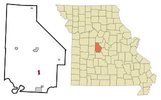
Gravois Mills is a town in Morgan County, Missouri, United States. The population was 144 at the 2010 census.

<span class="mw-page-title-main">Grantwood Village, Missouri</span> Town in Missouri, United States

Grantwood Village is a town in St. Louis County, Missouri, United States. The population was 863 at the 2010 census.

Navassa is a town in Brunswick County, North Carolina, United States. The population was 1,505 at the 2010 census, up from 479 in 2000.

<span class="mw-page-title-main">Shallotte, North Carolina</span> Town in North Carolina, United States

Shallotte is a town in Brunswick County, North Carolina, United States. The population was 3,675 at the 2010 census. The Shallotte River passes through the town.

<span class="mw-page-title-main">Drexel, North Carolina</span> Town in North Carolina, United States

Drexel is a town in Burke County, North Carolina, United States. The population was 1,858 at the 2010 census. It is part of the Hickory–Lenoir–Morganton Metropolitan Statistical Area.

Sandyfield is a town in Columbus County, North Carolina, United States. The population was 447 at the 2010 census.

<span class="mw-page-title-main">Pinetops, North Carolina</span> Town in North Carolina, United States

Pinetops is a town in Edgecombe County, North Carolina, United States. It is part of the Rocky Mount, North Carolina Metropolitan Statistical Area. The population was 1,374 at the 2010 census.

<span class="mw-page-title-main">Grimesland, North Carolina</span> Town in North Carolina, United States

Grimesland is a town in Pitt County, North Carolina, United States. The population was 441 at the 2010 census. The town is a part of the Greenville Metropolitan Area located in North Carolina's Inner Banks.

<span class="mw-page-title-main">Columbus, North Carolina</span> Town in North Carolina, United States

Columbus is a town and the county seat of Polk County, North Carolina, United States. The population was 999 at the 2010 census.

<span class="mw-page-title-main">Lodge, South Carolina</span> Town in South Carolina, United States

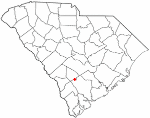
Lodge is a town in Colleton County, South Carolina, United States. The population was 120 at the 2010 census.

<span class="mw-page-title-main">Pinewood, South Carolina</span> Town in South Carolina, United States

Pinewood is a town located on South Carolina Highway 261 at the southern entrance to the High Hills of Santee in Sumter County, South Carolina, United States. The population was 538 at the 2010 census. It is included in the Sumter, South Carolina Metropolitan Statistical Area.

<span class="mw-page-title-main">Boykins, Virginia</span> Town in Virginia, United States

Boykins is a town in Southampton County, Virginia, United States. The population was 516 at the 2020 census.

<span class="mw-page-title-main">Washington, Eau Claire County, Wisconsin</span> Town in Wisconsin, United States

Washington is a town in Eau Claire County, Wisconsin, United States. The population was 7,182 at the 2010 census, making it the county's second-most-populous municipality. The town is located along most of the south side of the cities of Eau Claire and Altoona, Wisconsin. The unincorporated community of Brackett is located within the town.

<span class="mw-page-title-main">Chicog, Wisconsin</span> Town in Wisconsin, United States

Chicog is a town in Washburn County, Wisconsin, United States. The population was 268 at the 2000 census.

<span class="mw-page-title-main">Marbleton, Wyoming</span> Town in Wyoming, United States

Marbleton is a town in Sublette County, Wyoming, United States. The population was 1,094 at the 2010 census.

References

  1. "ArcGIS REST Services Directory". United States Census Bureau. Retrieved September 20, 2022.
  2. 1 2 U.S. Geological Survey Geographic Names Information System: Pollocksville, North Carolina
  3. 1 2 "U.S. Census website". United States Census Bureau . Retrieved January 31, 2008.
  4. Federal Writers' Project (1938). The Ocean Highway: New Brunswick, New Jersey to Jacksonville, Florida. Works Progress Administration. p. 115.
  5. "National Register Information System". National Register of Historic Places . National Park Service. July 9, 2010.
  6. "Census of Population and Housing". Census.gov. Retrieved June 4, 2015.
  7. "Explore Census Data". data.census.gov. Retrieved December 24, 2021.
  8. Bethea, Charles. "What Happens When the News Is Gone?". The New Yorker. Retrieved January 27, 2020.