
Arcot is a town and urban area of Ranipet district in the state of Tamil Nadu, India. Located on the southern banks of Palar River, the city straddles a trade route between Chennai and Bangalore or Salem, between the Mysore Ghat and the Javadi Hills. As of 2018, the city had a population 129,640. The sweet makkan peda is a local speciality while Arcot biryani, a rice-based traditional food, is also served here.

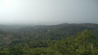
Chittoor is a city and district headquarters in Chittoor district of the Indian state of Andhra Pradesh. It is also the mandal and divisional headquarters of Chittoor mandal and Chittoor revenue division respectively. The city has a population of 153,756 and that of the agglomeration is 175,647.
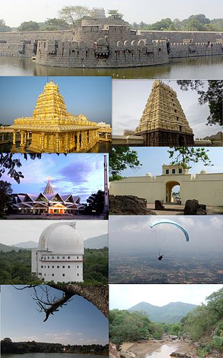
Vellore, also spelt as Velur, is a city and the administrative headquarters of Vellore district in the Indian state of Tamil Nadu. It is located on the banks of the Palar River in the northeastern part of Tamil Nadu and is separated into four zones that are further subdivided into 60 wards, covering an area of 87.915 km2 and housing a population of 423,425 as reported by the 2001 census. It is located about 137.20 kilometres (85 mi) west of Chennai, and about 213.20 kilometres (132 mi) east of Bangalore. Vellore is located on the Mumbai–Chennai arm of the Golden Quadrilateral. Vellore is governed under a mayor and the Vellore Municipal Corporation. It is a part of both the Lok Sabha and state assembly constituencies of Vellore.
Gudiyetram, colloquially Gudiyattam is a municipality in Vellore district in the state of Tamil Nadu in India. It lies between Bangalore and Chennai and the district of Vellore is 33 km away from the town. In 2011, the town had a population of 235,672. The municipality derives its name from 'Gudiye-tram' in Tamil which means habituation of people. The ancient occupation of the people of Guidyatham was handloom weaving.
Kuppam is a town in Chittoor district of the Indian state of Andhra Pradesh. It is located 115.8 kilometers south-east of Bangalore, the capital city of Karnataka, and 243 kilometers west of Chennai, the capital of Tamil Nadu. It is the headquarters of Kuppam mandal in the Kuppam Revenue Division. The name "Kuppam" means a meeting place or confluence.

Sholinghur is a municipality under Sholinghur taluk in Ranipet District of Tamil Nadu, India. The town is famous in Tamil Nadu and other neighboring states for the Lakshmi Narasimha Swamy temple.

Tiruttani is a town in Tiruvallur district, suburb of Chennai within Chennai Metropolitan Area limit in state of Tamil Nadu, India. This town is famous for Tiruttani Murugan Temple which is one of the Arupadaiveedu and is dedicated to (Kartikeya) Murugan.In October 2022 Tiruttani is a part of Chennai Metropolitan Area.
Kalavai is a panchayat town in Ranipet district in the Indian state of Tamil Nadu. The main occupation represented in the area is farming. The town has a pond and a lake after rainy season. Villagers use the lake water and palar river for irrigation. Corporation Bank, State Bank Of India and Indian Bank are the banks that have branches in the locality. The secondary occupation is garment outlets. One government higher secondary school is also located in a nearby village.
Kaveripakkam is a town panchayat in Ranipet district in the Indian state of Tamil Nadu.
Pallipattu is a town in Tamil Nadu and a border town located between the Chittoor District of Andhra Pradesh and Tiruvallur District of Tamil Nadu. It is known for its rich and fertile agricultural lands and is blessed with the flowing of river, from west to east, named 'Kusasthalai'.
Podaturpet is a Town under Pallipattu(Pallipet) Taluk in Thiruvallur district in the Indian state of Tamil Nadu.

Pakala is a town in Tirupati district of the Indian state of Andhra Pradesh. It is the mandal headquarters of Pakala mandal. It comes under Tirupati revenue division.
Dakshina Patha Pathapalem, sometimes shortened to D.P. Palayam, is a village located in Gudiyattam Taluk in the Vellore district, Tamil Nadu, India. It is located approximately 1 km (0.62 mi) from the border with Andhra Pradesh and 4 km (2.5 mi) from Paradarami. It is a small village and has about 50 other villages surrounding it. The official languages are Telugu and Tamil. The village is surrounded by hills on all the sides and has an old temple—Veera Vijaya Anjaneya Swamy Temple—which has been renovated.
Karivedu is famed village is located in Ranipet district, Tamil Nadu. The initial present in the name of the village literally signifies the town Kalavai which is present nearby to the village. To discriminate karivedu from Vellore district the name is used by Karivelangadu. Karivedu is situated in between Arcot and Kalavai road. It is 15 km from Arcot and 8 km from Kalavai. It belongs to Arcot municipality and taluk. The postal pincode is 632506.
Sakkaramallur is an Indian village panchayat located in Arcot Taluk of Vellore District in the state of Tamil Nadu. Sakkaramallur is located on Right Bank of Palar River.
The town of Viluppuram in the Indian state of Tamil Nadu is well connected by both rail and road to other major cities in the state including Chennai, Trichy, Madurai, Salem, Thanjavur, Coimbatore, Dindigul and Vellore. And also other state major cities such as Bengaluru, Tirupati, Pondicherry and Mangalore. Viluppuram serves as one of the important railway junction of Tamil Nadu and Southern Railway Zone. The nearest domestic airport is Pondicherry, which has a daily chartered flight to Bengaluru. The nearest international airports are Chennai and Tiruchirappalli.
Tiruvannamalai is predominantly connected by road to other major cities in the state including Chennai, Bengaluru, Vellore, Arani, Trichy, Tiruppur, Salem, Thanjavur, Coimbatore, Shimoga and Kanchipuram. And also other state major cities such as Hyderabad, Tirupati, Puducherry and Mangaluru. Tiruvannamalai serves as one of the important Road junction of Tamil Nadu and north roadways Zone. The nearest domestic airport is Vellore, which has a no daily chartered flights. The nearest international airports are Chennai and Tiruchirappalli.
Kandipedu is a village in Katpadi, at the northern part of Vellore city in the Indian state of Tamil Nadu. It sits on the Katpadi-Vallimalai railway line, near Thiruvalluvar University, one of India's premier educational institutions.
Tirupattur district, or Tirupathur district, is one of the 38 districts in the southern Indian state of Tamil Nadu. The district was formed in 2019 by the division of Vellore district into three smaller districts. Its creation alongside Ranipet district was announced on 15 August 2019, and it was officially declared on 28 November 2019. The town of Tirupattur serves as the district headquarters.
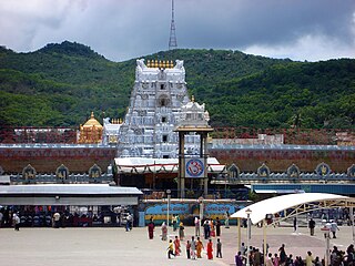
Tirupati district is one of the twenty-six districts in the Indian state of Andhra Pradesh. The district headquarters is located at Tirupati city. Tirupati district is known for its numerous historic temples, including the Hindu shrine of Tirumala Venkateswara Temple, Sri Kalahasteeswara temple and many others.The district is also home to Satish Dhawan Space Centre, a rocket launch centre located in Sriharikota and operated by Indian Space Research Organisation (ISRO). The river Swarnamukhi flows through Tirupati, Srikalahasti and joins with the Bay of Bengal in this district. Industries include groundnuts and paddy fields.
