The geography of Papua New Guinea describes the eastern half of the island of New Guinea, the islands of New Ireland, New Britain and Bougainville, and smaller nearby islands. Together these make up the nation of Papua New Guinea in tropical Oceania, located in the western edge of the Pacific Ocean.

Wewak is the capital of the East Sepik province of Papua New Guinea. It is on the northern coast of the island of New Guinea. It is the largest town between Madang and Jayapura. It is the see city (seat) of the Roman Catholic Diocese of Wewak.
Kokoda is a station town in the Oro Province of Papua New Guinea. It is famous as the northern end of the Kokoda Track, site of the eponymous Kokoda Track campaign of World War II. In that campaign, it had strategic significance because it had the only airfield along the Track. In the decades preceding, it had been a foothills settlement near the gold fields.
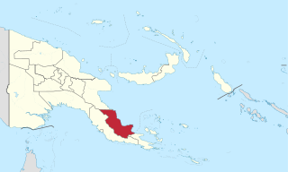
Oro Province, formerly Northern Province, is a coastal province of Papua New Guinea. The provincial capital is Popondetta. The province covers 22,800 km2, and has 176,206 inhabitants. The province shares land borders with Morobe Province to the northwest, Central Province to the west and south, and Milne Bay Province to the southeast. The province is located within the Papuan Peninsula.

Education in Papua New Guinea is managed through nineteen provinces and two district organisational units. It is tuition-free and attendance is not compulsory.

The Anglican Church of Papua New Guinea is a province of the Anglican Communion. It was created in 1977 when the Province of Papua New Guinea became independent from the Province of Queensland in the Church of England in Australia following Papua New Guinea's independence in 1975.

Alotau is the capital of Milne Bay Province, in the south-east of Papua New Guinea. It is located on the northern shore of Milne Bay. The town is located within Alotau Urban LLG.

Sorong is the largest city and the capital of the Indonesian province of Southwest Papua. The city is located on the western tip of the island of New Guinea with its only land borders being with Sorong Regency. It is the gateway to Indonesia's Raja Ampat Islands, species rich coral reef islands in an area considered the heart of the world's coral reef biodiversity. It also is the logistics hub for Indonesia's thriving eastern oil and gas frontier. Sorong has experienced exponential growth since 2010, and further growth is anticipated as Sorong becomes linked by road to other frontier towns in Papua's Bird's Head Peninsula. The city had a population of 190,625 at the 2010 Census and 284,410 at the 2020 Census; the official estimate was 295,809. In mid 2022, 47.34% of the city population were Protestant, 44.82% were Muslim, and 7.55% Catholic, with minorities of Buddhists and Hindus. The city is served by Domine Eduard Osok Airport.
Aristolochia schlechteri, synonym Pararistolochia schlechteri, is a liana endemic to Papua New Guinea. It was first described by Carl Lauterbach in 1905. Although its distribution is supposedly restricted to the Northern Province, there have been two rare accounts of occurrences in the Madang and East Sepik Provinces.
This page is a list of districts of Papua New Guinea.
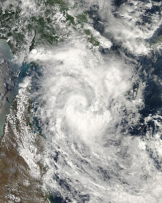
Severe Tropical Cyclone Guba was the most recent tropical cyclone to form in the Port Moresby area of responsibility. The storm resulted in 149 fatalities and severe damage across southeastern Papua New Guinea in November 2007. The firstly-named cyclone of the 2007–08 Australian region cyclone season, Guba formed on 13 November 2007 close to the island of New Guinea, and reached tropical cyclone intensity the next day by the Tropical Cyclone Warning Centre (TCWC) in Brisbane, with the TCWC in Port Moresby assigning the name Guba. It meandered in the northern Coral Sea for the next week, strengthening to a Category 3 severe tropical cyclone on 16 November. It posed a threat to the Australian Cape York Peninsula, but remained offshore, and finally dissipated on 20 November.

The continent of Australia, sometimes known in technical contexts by the names Sahul, Australia-New Guinea, Australinea, Meganesia, or Papualand to distinguish it from the country of Australia, is located within the Southern and Eastern hemispheres. The name "Sahul" takes its name from the Sahul Shelf, which is a part of the continental shelf of the Australian continent. The continent includes mainland Australia, Tasmania, the island of New Guinea, the Aru Islands, the Ashmore and Cartier Islands, most of the Coral Sea Islands, and some other nearby islands. Situated in the geographical region of Oceania, Australia is the smallest of the seven traditional continents.

New Guinea is the world's second-largest island, with an area of 785,753 km2 (303,381 sq mi). Located in Melanesia in the southwestern Pacific Ocean, the island is separated from Australia by the 150-kilometre wide Torres Strait, though both landmasses lie on the same continental shelf. Numerous smaller islands are located to the west and east.

Pilot Point Airport is a state-owned, public-use airport located in Pilot Point, a city in the Lake and Peninsula Borough of the U.S. state of Alaska. Scheduled airline service to King Salmon Airport is provided by Grant Aviation.
Sir George Ambo KBE, originally named Ambo Arukaba after his father and grandfather, was a Papua New Guinean Anglican bishop. He was the first South Pacific native to become a bishop, in 1960. He was also known for his role in a "cargo cult" in the months prior to his death.
Akoka Doi is a Papua New Guinean politician. He was a member of the National Parliament of Papua New Guinea from 1977 to 1992, representing the electorate of Ijivitari Open.

Popendetta Rural LLG is a local-level government (LLG) of Oro Province, Papua New Guinea.

Paulus Arek was a Papua New Guinean politician and trade unionist. He served as a member of the House of Assembly between 1968 and 1973, and as Minister for Information from 1972 to 1973.
Newton Theological College is a Papua New Guinean educational institution in Popondetta, Papua New Guinea. It trains candidates for ordination in the Anglican Church of Papua New Guinea.