In early January 1951, a series of minor explosions and earthquakes rocked Mount Lamington, a volcano in Oro Province, Territory of Papua and New Guinea. Prior to the eruption, Mount Lamington was not recognized as a volcano due to the absence of historically-recorded eruptions and dense vegetation cover. From January 15, volcanic activity intensified, and tall eruption plumes were generated. The largest eruption occurred on the morning of January 21 when a thick black plume of ash rose 15,000 metres (50,000ft) into the atmosphere.[1] The eruption collapsed a lava dome and produced a lethal pyroclastic flow that killed 2,942 people. In the years after the eruption, new lava domes formed and collapsed in succession. Activity persisted until July 1956. The eruption is the deadliest natural disaster in Australian history, as the region was under the rule of the Government of Australia.
Volcanism in Papua New Guinea is due to the ongoing subduction of oceanic crust beneath the island due to plate tectonics. Mount Lamington is situated within the Hydrographers Range; a small, forested coastal mountain range. The mountain range is the remnant of a heavily eroded Quaternarystratovolcano. The dominant rock types are andesite and basaltic andesite. While a majority of the range's eruptive history occurred during the Pleistocene, the presence of cinder cones and craters on the southern flank of the range suggest volcanism also took place during the Holocene. The mountain lies adjacent to the Owen Stanley Range. Nearby volcanoes include Mount Suckling and Mount Victory.[2]
Volcanology
Mount Lamington and the Hydrographers Range are of volcanic origin
Mount Lamington rises to a height of 1,680 meters above the coastal flats north of the Owen Stanley Range. A summit complex of lava domes and crater remnants rises above a low-angle base of volcaniclastic deposits that are dissected by radial valleys. A prominent broad "avalanche valley" extends northward from the breached crater.[3] The horseshoe-shaped crater was the result of a large sector collapse. It occurred about 20,000 years Before Present, when the volcano was approximately 2,560 metres (8,400ft) high. A 1,060-metre (3,480ft) section of the volcanic cone, estimated to be 0.47 cubic kilometres (0.11cumi), was destroyed by the collapse during this prehistoric eruption.[4]
Prior to the eruption in 1951, Mount Lamington was not known by locals to be an active volcano as no widespread ancient folklore or stories of the volcano existed among the native population. The only indication of volcanic activity was a small hot spring on the northern slopes, which was not known by most of the native population.[2] There were also settlements located on the flank of the volcano. A weak hint of its volcanic nature was a traditional story, related to the volcano's activity, of a lake on the summit which exploded, destroying villages and killing many people. The native population regards the mountain as a sacred and spiritual place.[5][6]
Geologists however, understood that Mount Lamington and the Hydrographers Range were volcanic in origin, and that it was a geologically young feature. A geologist from the Netherlands classified Mount Lamington an active volcano.[7] Only three eruptions were confirmed in the Holocene.[2]
Events
A map of Mount Lamington and its surroundings from 1962
Pre-January 21 activity
A number of inhabitants around Mount Lamington reported earthquakes in early January 1951. One eyewitness also saw a strange light on New Year's Day of 1951.[8]
On the morning of January 15, residents saw evidence of landslides in the crater wall of the volcano. Landslide scars identified as streaks of brown in the heavily forested volcano flank indicated the volcano was active. At a rubber plantation in Sangara, a village, a person reported white smoke or vapour cloud rising from the base of the volcano. Around the crater, vegetation was killed by the intense heat emitted from the ground.[8]
The following day, January 16, a vapour cloud was seen from Higaturu. Large landslides were reported, many destroying the existing vegetation. The entire rainforest around the crater was destroyed by the late afternoon. An earthquake swarm occurred at 16:00. Up to 30 earthquakes were felt till 08:00 on January 17. Stronger earthquakes were felt in Isivita Mission, located northwest of the crater.[9]
On January 17, an ash column rising between some hills and Mount Lamington was observed. The column grew larger as the hours passed. Earthquakes continued to be felt, and there was a red glow observed at night. By January 18, large plumes of dark grey ash ejected from the volcano. A large explosion occurred in the morning. A newly-constructed volcanic hill where volcanic material escaped was observed. The eruptions did not cause any human deaths, according to District Commissioner Cecil Cowley on January 19. Large columns of ash rising 20,000–25,000 feet (6,100–7,600m) could be observed from Popondetta.[10]
The eruption column was 25,000–30,000 feet in height by January 20. From Kokoda, the eruption was described as a large black column, and had a shape reminiscent of a cauliflower. Monsoon winds caused heavy ashfall on the southern side of the volcano. Some settlements where the Orokaiva people lived were damaged.[11]
January 21 eruption
The eruption on 21 January 1951 was photographed by pilot of a flight from Port Moresby to Rabaul, from about 40 km NW. The ash plume rose to a height of about 13 km within two minutes then expanded horizontally away from the volcano.
The most violent eruption occurred four days later at 10:40 local time. Occupants on two Qantas Empire Airways flights which flew in close proximity to the erupting volcano reported a large eruption column and base surge of pyroclastic debris. The captain of a Douglas DC3 flight witnessed a massive continuous column of black smoke erupting from the crater. The column rose over 14,000 feet (4,300m), punching through a layer of clouds. In two minutes, the column had risen 40,000 feet (12,000m) from the crater, and expanded into a mushroom column. The eruption column reached 50,000 feet (15,000m) at its highest.[12] The captain of the DC 3 radioed authorities at Port Moresby about the sequence of events. Another Qantas flight; a de Havilland Dragon bound for Popondetta from Lae, was about to land when its occupants witnessed the side of volcano blow itself apart. A large surge of debris approached the aircraft, forcing its return to Lae.
Changing winds directed the pyroclastic surge northeast, where it was seen at Kokoda. Lightning was observed in the eruption column. Ash, pumice and small rocks fell to the ground. The eruption column was also observed at Eroro, where many residents mistook it for a petrol explosion at Higaturu. A large pyroclastic surge raced towards Isivita Mission; 75 kilometres (47mi) northwest of the crater. Many panicked residents rushed to the main mission house. The flow however, ceased in the mission compound. A definitive boundary between the grassy field and thick layer of volcanic material marked the trail of the flow. By 11:30, the eruption column had blocked sunlight. Thunder was heard, and intense lightning was observed.[12]
Awala Plantation near Isivita Mission was spared the worst of the eruption but suffered from extensive ash fall. Much of the rubber, coffee and cocoa crops were devastated. The loss of crops had implications for the local economy. The eruption seriously affected the fish population in rivers. The local population experienced a decline in the aftermath of the eruption. Rainforests were also covered in thick layers of ash, and trees began to topple or break apart due to the weight of ash.[12] Overnight, 18 people perished at Isivita. Higaturu, another town slightly further away was totally destroyed.
The lava spine which emerged from the lava dome reached 150m (490ft) on 19 August 1951
By the afternoon, many residents with extreme burns from the pyroclastic flow were rescued. Many began to arrive at treatment centers for medical assistance. Survivors described the sounds of agony from burn victims. Some victims experienced total burns to their skins. One burn victim later died. More deaths were anticipated following the eruption, so a large grave was dug. There was a large inflow of seriously burnt victims at the Sangara Plantation. Injured victims were also transported to Popondetta.[12]
The destruction was described as "complete" and comparisons were drawn with a bomb explosion. Trees in the dense tropical rainforest toppled or were pulverized. Nearly every building was decimated by the flow. The region surrounding Mount Lamington was transformed into a moonscape-like environment. Charred bodies of people attempting to flee the surging flow littered the roads.[7]
Post-January 21 activity
The post-January 21 eruptive phase consisted of explosive eruptions which produced pyroclastic flows. A large pyroclastic flow was documented on March 5, 1951. After the climactic eruption on January 21, a new lava dome formed in the crater. The new lava dome grew to fill the crater. From 1951 to 1953, new lava domes formed and collapsed, generating more pyroclastic flows. The dome eventually attained a height of 450 meters from the crater floor to its summit and had a volume of 0.2km3 (0.048cumi).[4] A lava spine emerged from the dome and grew to a height of 150m (490ft). Lava spines continuously formed and were destroyed over a five-year period.[3]
Scientific study and monitoring
Volcanologist Tony Taylor observing Mount Lamington on 5 February 1951
The eruption rated a 4 on the Volcanic Explosivity Index scale of 0 to 8.[3] This vertical eruption blast was accompanied by a lateral collapse of the volcano flank.[4]
At the time of the eruption, volcanologistTony Taylor was studying the Rabaul caldera, another volcano in Papua New Guinea. He arrived one day after the eruption. Taylor conducted a dangerous on-site investigation to determine the probability of another eruption, including a flight over the erupting crater.[13]
Mount Lamington was continuously monitored due to the potential for future eruptions. Taylor spent two years studying the volcano, where he received support from the Bureau of Mineral Resources, Geology and Geophysics (BMR). Seismologist Bill Langron and geologist John Best also assisted in the scientific study.[14] A de Havilland Mosquito of the No. 87 Squadron RAAF conducted a reconnaissance flight in the affected area.[13] Photographs taken during the flight were used in mapping the devastation's reach and change in topography around Mount Lamington.[15] There were concerns of an imminent eruption of Mount Victory, another volcano near Tufi and Wanigela. An inspection of the volcano suggest there was no threat.[16]
Taylor interpreted that the landslides initially observed were the result of the earthquake swarm or other geological processes.[17] Intense activity occurred in the subsequent days after, including an interpreted Vulcanian eruption on 17 January. That eruption was caused by magma interacting with groundwater. The young hill structure observed via a telescope and initially interpreted by Taylor as a pile of debris, was instead a small lava dome.[4]
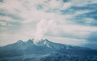
Mount Lamington photographed in February 1951
The large volume of volcanic ash and debris ejected vertically into the atmosphere on 21 January was a Plinian-style eruption. This triggered a debris avalanche with an estimated volume of 0.02–0.04 cubic kilometres (0.0048–0.0096cumi) which traveled 8.5 kilometres (5.3mi). The eruption column formed a large mushroom cloud towering over the summit. Pyroclastic flows surged down the flank of the volcano as the eruption column collapsed. The thick and dense cloud of black ash was described as "like toothpaste from a tube".[17] An approximately 230km2 (89sqmi) area of dense tropical rainforest around Mount Lamington was devastated.[4]
The pyroclastic flows moved with such a velocity that no humans in the areas of devastation survived. Extreme damage occurred within a 12km (7.5mi) radius around the volcano.[3] The flow moved at 135km (84mi) per hour—twice that of the de Havilland Dragon Qantas flight. It traveled northwards for 13km (8.1mi) due to the influence of the breached, horseshoe-shaped crater in the north. A second eruption occurred at 19:30, generating an ash cloud almost identical in height as the daytime eruption. This eruption produced a loud sound and heavy ashfall, although no pyroclastic flows were reported.[4]
As far as 3 kilometres (1.9mi) from the crater, some areas of rainforest were charred. In the areas where charring occurred, the pyroclastic flow was extremely dense. This allowed the flows to retain its extreme temperatures and cause severe scraping in the ground. Hundreds died at Higaturu from the heat of the pyroclastic flows. However, the temperatures were not sufficient for wood to combust and thermally decompose. In one house at Higaturu, a cotton reel and drive belt from a sewing machine remained unaffected. In another house, a plastic lampshade melted and collapsed. Two unburnt violins were also found inside a residence.[18]Penicillin found in a hospital were analyzed and showed that temperatures rose to 200°C for a period of 1.5–2 minutes.[17]
Only one house remained intact at Higaturu; the rest were obliterated, leaving only the floors intact. A previously straight steel pole on the hospital was severely bent in two places, and one side was eroded by the dense cloud. The discovery of a jeep hanging on the remains of a tree suggested vortices formed within the dense flow. Debris were picked up and flung into structures. Taylor concluded that winds inside the flow reached 75 kilometres (47mi) per hour.[17]
Casualties
The force of the blast left the remains of a jeep suspended on a tree
Rough estimates of the death toll appeared as early as 23 January which suggested 4,000 deaths. A thorough count did not happen because bodies were buried within days to weeks of the disaster. Port Moresby officials conveyed to the Department of External Territories; 3,466 people dead or missing. An administration official in Port Moresby performed an investigation of the local population from August to October and concluded that 2,907 people died.[19] The total death toll amounted to 2,942 when 35 Australian expatriates missing and presumed dead were added to the figure[19]—14 bodies were recovered two years after the eruption.[20]
The majority of those killed resided in the village of Sangara, part of a large preliterate society referred by colonial powers as the Orokaiva people.[20] Up to 94 percent of the population may have perished.[19] Deaths as a direct effect of the pyroclastic flows were similar to those observed after the 1902 eruption of Mount Pelée and La Soufrière. The ingestion of hot volcanic material caused the victims' respiratory system to swell, exfoliate, and eventually rupture. The condition of bodies also suggested fatal asphyxiation. Rigor mortis was observed; many in a sitting or kneeling position due to thermal-induced muscle stiffness. The intact bodies indicated victims did not die from flying objects or collapsed structures.[18]
At refugee centers, poor hygiene led to health issues; three people eventually died, including a child who succumbed to pneumonia.[18] It is unknown how many more people underwent psychological distress from the disaster as no counselling services were provided.[21]AnthropologistMarie Reay who was among the survivors experienced a mental breakdown in 1952 and was hospitalized. Some schoolchildren also struggled with grief after the disaster. An Orokaiva woman died from suicide after finding the remains of her husband and child following the eruption.[21] The eruption left a further 5,000 homeless.[22]
Survivors
Initially, 40 people were found alive and brought to a hospital but 22 died within 24 hours.[1] There were a number of people who were severely burnt but survived the pyroclastic surge. Near the village of Amonikiarota, a woman suffered burns by the tiny particles of lava that struck her skin. The thin cotton dress she wore had shielded much of her body from the advancing hot clouds. Some furry animals including a puppy and mouse also survived.[23]
One native man and two others attempted to flee the eruption along the Ambogo river, but the pyroclastic flow knocked them into the river. After being knocked unconscious for a moment, he was able to recover. When he resurfaced and attempted to breathe, his throat was burned. He sank into the river just when the highest temperatures of the surging flow were passing above and resurfaced later. Of the three, only the man survived (a second initial survivor died from her injuries).[23]
Response
Preparation for the eruption on January 21 was insufficient. Despite the precursor events of 15–17 January, little was known if news of the events reached administration headquarters in Port Moresby. At the time of the disaster, there was no administration to handle volcanic disaster, hence, no evacuation plan for the region around Mount Lamington. District Commissioner Cecil Cowley requested authorities in Port Moresby and a volcanologist to examine the situation, but his requests were never met. Volcanologist Tony Taylor said despite the intense activity leading up to the eruption, authorities were incapable of interpreting them as warning signs and managing the crisis.[12]
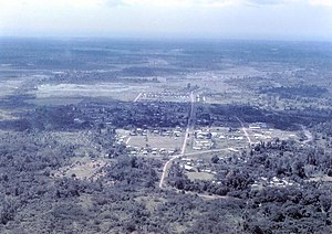
Popondetta was the center of relief efforts in the aftermath of the eruption
The administration in Port Moresby was briefed of the disaster on the morning of January 22. A relief and recovery mission was established in response. Aircraft delivered excess food, tents, medical and other supplies to the affected regions effectively. At Lae, the Huon, an administrative ship, sailed overnight with medical staff and emergency needs to Popondetta. Rescuers found very few survivors in the affected area—there were more dead bodies recovered. The injured were airlifted from Popondetta to Port Moresby for treatment. Displaced residents were relocated to refugee camps which provided with basic needs.[24]
An undamaged road linking Gona to Kokoda which ran north of Mount Lamington served an important role in the rescue and recovery process. The road helped with the mobilization of injured victims, emergency responders and evacuees. Volcanic ashfall continued to disrupt response operations in the hours that came. Another nighttime eruption that same day caused panic. Ash from the eruptions fell in Port Moresby, forcing the airport to cease operations until the following morning.[7]
Two RAAFC-47 Dakota deployed by the Australian government assisted in the response. The Australian Red Cross also donated blood plasma for injured victims which was transported by the aircraft. Food, medical supplies and basic needs were delivered as well.[13]
Aftermath
A rope bridge linked Wairopi and the opposite bank of the river
An evacuation site at Wairopi was formed within days of the eruption on the floodplain of the Kumusi River, along a road that linked Kokoda and Popondetta. The site was located far from Mount Lamington so there was no volcanic threat. The Kumusi River supplied water for drinking and cleaning. There were possibly over 4,000 refugees at Wairopi—mainly because many were using the road to leave the affected area and this was an effort to concentrate recovery efforts.[25] Refugees included the Orokaiva, Omie, Koiarian-speaking groups, and some members of the Sangara people.[26]
Whooping cough was still persistent among the population as the outbreak occurred before the eruption. There was a heightened risk of dysentery, typhoid, tuberculosis and pneumonia. Medical workers also had to deal with malaria. Due to these health concerns, immunization programs were introduced. Medical supplies were brought to the site by road after being flown into Kokoda. Food supplies such as rice and canned meat were air-dropped, and there was a farm to grow vegetables.[26]
Wairopi was at risk of flooding in February when mudflows around the volcano blocked river channels with silt. A survey was carried out at the source of the Kumusi River. The Mamama River, its main tributary, carried large quantities debris from the southern flanks of Mount Lamington. Logs from the devastated vegetation blocked parts of the river. Flooding at Wairopi occurred on 8 February, and again on 19 February, washing away the evacuation site. The village of Ajeka on the opposite bank was flooded.[27]
A new evacuation site, Ilimo, was established west of Wairopi. Along the road, the site was 6.5km (4.0mi) away from Wairopi and closer to Kokoda. Local villages accommodated roughly 2,000 refugees. The other 2,000 refugees walked to Ilimo by road while the sick and frail were ferried by jeeps. Additional refugees from Oro Bay also moved to Ilimo. Heavy rain disrupted the construction of infrastructure.[27] Homes and other facilities including a temporary hospital were constructed. Villages and refugees participated in the construction. The new site supported agriculture, education and health programs. By the end of February, more than 3,840 and 3,150 injections for whooping cough and typhoid were administered, respectively. Health measures were taken to prevent diseases from spreading.[28]
Evacuation sites were also located at Eroro, Oro Bay, Popondetta and Inonda.[29]
Rehousing
Administration officials and displaced locals agreed that the devastated areas were unsuitable for rebuilding. Building new villages along a road linking Waseta and Popondetta was preferred by the administration. Known as Saiho, these villages would allow the Orokaiva people to access native lands. The villages were intended to mirror Kokoda—large communities with an approximate population of 400. Under the supervision of administration officers, the native male population constructed these villages. A hospital comprising 11 wards was also built.[30] Most of the refugees had been relocated to Saiho—by mid-May, there were only 530 people at Ilimo. Most of the population at Popondetta and Inonda sites had left. The evacuation site Ilimo closed on 1 June. Evacuation sites at Oro Bay and Eroro had been emptied by May.[29]
Explosions occur behind the lava dome of Mount Lamington
Vegetation quickly blossomed as volcanic activity began to decrease. The orange-yellow Neurosporafungus was discovered in the pyroclastic deposit zone three days after the eruption. The subjection of its ascospores momentarily to high temperatures resulted in a booming population. Over a period of six weeks, the fungus population declined until it was a rarity. Occasionally, they appeared on logs that were buried under ash and debris.[24]
Plants that were cultivated by the local population also survived the devastation. The severely damaged coffee and rubber tree plantations regrew and were eventually sufficient to sustain the native population. Tubers were the first plants to appear. It was followed by native grasses and the rainforest trees. Less than a week after the eruption, taro plants began blossoming in some villages. Root vegetables including yam and sweet potato, as well as banana plants started to grow two months later. The regrowth became an important source of food for the population.[31]
Grasses began to cover the mountainside by early 1952. Erosion on the mountain stripped away some of the new ash layer, revealing the pre-eruption soil. The regrowth of trees occurred around this period, and by the end of the year, some were 15 feet (4.6m) high. The volcanic crater became increasingly inaccessible due to the tall grasses and dense vegetation. There were no vegetation on the smouldering lava dome until 1953 when grasses began to appear.[31]
Memorial and legacy
The Mount Lamington Memorial Cemetery opened on 24 November 1952 at Popondetta by the Australian colonial government.[24] Bodies of the Orokaiva people, Europeans and local policemen were buried. At Higaturu, bodies were exhumed and reburied. The memorial cemetery featured a large white Christian cross in the ground. The opening ceremony was officiated by Minister for TerritoriesPaul Hasluck.[32]
A volcano is a rupture in the crust of a planetary-mass object, such as Earth, that allows hot lava, volcanic ash, and gases to escape from a magma chamber below the surface.
Mount St. Helens is an active stratovolcano located in Skamania County, Washington, in the Pacific Northwest region of the United States. It lies 52 miles (83 km) northeast of Portland, Oregon, and 98 miles (158 km) south of Seattle. Mount St. Helens takes its English name from that of the British diplomat Alleyne Fitzherbert, 1st Baron St Helens, a friend of explorer George Vancouver who surveyed the area in the late 18th century. The volcano is part of the Cascade Volcanic Arc, a segment of the Pacific Ring of Fire.
A stratovolcano, also known as a composite volcano, is a conical volcano built up by many layers (strata) of hardened lava and tephra. Unlike shield volcanoes, stratovolcanoes are characterized by a steep profile with a summit crater and periodic intervals of explosive eruptions and effusive eruptions, although some have collapsed summit craters called calderas. The lava flowing from stratovolcanoes typically cools and solidifies before spreading far, due to high viscosity. The magma forming this lava is often felsic, having high to intermediate levels of silica, with lesser amounts of less viscous mafic magma. Extensive felsic lava flows are uncommon, but have traveled as far as 15 km (9 mi).
Mayon, also known as Mount Mayon and Mayon Volcano, is an active stratovolcano in the province of Albay in Bicol, Philippines. A popular tourist spot, it is renowned for its "perfect cone" because of its symmetric conical shape, and is regarded as sacred in Philippine mythology.
Volcanic cones are among the simplest volcanic landforms. They are built by ejecta from a volcanic vent, piling up around the vent in the shape of a cone with a central crater. Volcanic cones are of different types, depending upon the nature and size of the fragments ejected during the eruption. Types of volcanic cones include stratocones, spatter cones, tuff cones, and cinder cones.
The Lassen volcanic area presents a geological record of sedimentation and volcanic activity in and around Lassen Volcanic National Park in Northern California, U.S. The park is located in the southernmost part of the Cascade Mountain Range in the Pacific Northwest region of the United States. Pacific Oceanic tectonic plates have plunged below the North American Plate in this part of North America for hundreds of millions of years. Heat and molten rock from these subducting plates has fed scores of volcanoes in California, Oregon, Washington and British Columbia over at least the past 30 million years, including these in the Lassen volcanic areas.
Lassen Peak, commonly referred to as Mount Lassen, is a 10,457 ft (3,187 m) lava dome volcano in Lassen Volcanic National Park in Northern California. Located in the Shasta Cascade region above the northern Sacramento Valley, it is the southernmost active volcano in the Cascade Range of the Western United States, and part of the Cascade Volcanic Arc stretching from southwestern British Columbia to northern California. It supports many flora and fauna among its diverse habitats, which reach high elevations and are subject to frequent snowfall.
On March27, 1980, a series of volcanic explosions and pyroclastic flows began at Mount St. Helens in Skamania County, Washington, United States. A series of phreatic blasts occurred from the summit and escalated until a major explosive eruption took place on May18, 1980, at 8:32am. The eruption, which had a volcanic explosivity index of 5, was the first to occur in the contiguous United States since the much smaller 1915 eruption of Lassen Peak in California. It has often been declared the most disastrous volcanic eruption in U.S. history.
Mount Unzen is an active volcanic group of several overlapping stratovolcanoes, near the city of Shimabara, Nagasaki on the island of Kyushu, Japan's southernmost main island.
Mount Spurr (Dena'ina: K'idazq'eni) is a stratovolcano in the Aleutian Arc of Alaska, named after United States Geological Survey geologist and explorer Josiah Edward Spurr, who led an expedition to the area in 1898. The Alaska Volcano Observatory (AVO) currently rates Mount Spurr as Level of Concern Color Code Green. The mountain is known aboriginally by the Dena'ina Athabascan name K'idazq'eni, literally 'that which is burning inside'.
Santa María Volcano is a large active volcano in the western highlands of Guatemala, in the Quetzaltenango Department near the city of Quetzaltenango. It is part of the mountain range of the Sierra Madre.
The Soufrière Hills are an active, complex stratovolcano with many lava domes forming its summit on the Caribbean island of Montserrat. After a long period of dormancy, the Soufrière Hills volcano became active in 1995 and has continued to erupt ever since. Its eruptions have rendered more than half of Montserrat uninhabitable, destroying the capital city, Plymouth, and causing widespread evacuations: about two-thirds of the population have left the island. Chances Peak in the Soufrière Hills was the highest summit on Montserrat until the mid-1990s, but it has since been eclipsed by various rising and falling volcanic domes during the recent volcanic activity.
Augustine Volcano is a stratovolcano in Alaska consisting of a central complex of summit lava domes and flows surrounded by an apron of pyroclastic, lahar, avalanche, and ash deposits. The volcano is frequently active, with major eruptions recorded in 1883, 1935, 1963–64, 1976, 1986, and 2006. Minor eruptive events were reported in 1812, 1885, 1908, 1944, and 1971. The large eruptions are characterized by an explosive onset followed by the quieter effusion of lava. It forms Augustine Island in southwestern Cook Inlet in the Kenai Peninsula Borough of southcentral coastal Alaska, 174 miles (280 km) southwest of Anchorage. Augustine Island has a land area of 32.4 square miles (83.9 km2), while West Island, just off Augustine's western shores, has 2 sq mi (5.2 km2). The irregular coastline of Augustine Island is due to the repeated catastrophic collapse of the summit dome, forming debris avalanches down the flanks and into Cook Inlet.
Mount Lamington is an andesitic stratovolcano in the Oro Province of Papua New Guinea. The forested peak of the volcano had not been recognised as such until its devastating eruption in 1951 that caused about 3,000 deaths.
Peléan eruptions are a type of volcanic eruption. They can occur when viscous magma, typically of rhyolitic or andesitic type, is involved, and share some similarities with Vulcanian eruptions. The most important characteristic of a Peléan eruption is the presence of a glowing avalanche of hot volcanic ash, called a pyroclastic flow. Formation of lava domes is another characteristic. Short flows of ash or creation of pumice cones may be observed as well.
Lascar is a stratovolcano in Chile within the Central Volcanic Zone of the Andes, a volcanic arc that spans Peru, Bolivia, Argentina and Chile. It is the most active volcano in the region, with records of eruptions going back to 1848. It is composed of two separate cones with several summit craters. The westernmost crater of the eastern cone is presently active. Volcanic activity is characterized by constant release of volcanic gas and occasional vulcanian eruptions.
Mount Sinabung is a Pleistocene-to-Holocene stratovolcano of andesite and dacite in the Karo plateau of Karo Regency, North Sumatra, Indonesia, 40 kilometres (25 mi) from the Lake Toba supervolcano. Many old lava flows are on its flanks and the last known eruption, before recent times, occurred 1200 years before present, between 740 - 880 CE. Solfataric activities were last observed at the summit in 1912; recent documented events include an eruption in the early hours of 29 August 2010 and eruptions in September and November 2013, January, February and October 2014. The volcano has recently claimed the life of at least 23 people in a number of events since 2014. Between 2013 and 2014, the alert for a major event was increased with no significant activity. On 2 June 2015, the alert was again increased, and on 26 June 2015, at least 10,000 people were evacuated, fearing a major eruption. The long eruption of Mount Sinabung is similar to that of Mount Unzen in Japan, which erupted for five years after lying dormant for 400 years. A major eruption began on 10 August 2020.
Several types of volcanic eruptions—during which material is expelled from a volcanic vent or fissure—have been distinguished by volcanologists. These are often named after famous volcanoes where that type of behavior has been observed. Some volcanoes may exhibit only one characteristic type of eruption during a period of activity, while others may display an entire sequence of types all in one eruptive series.
The Bridge River Vent is a volcanic crater in the Pacific Ranges of the Coast Mountains in southwestern British Columbia, Canada. It is located 51 km (32 mi) west of Bralorne on the northeastern flank of the Mount Meager massif. With an elevation of 1,524 m (5,000 ft), it lies on the steep northern face of Plinth Peak, a 2,677 m (8,783 ft) high volcanic peak comprising the northern portion of Meager. The vent rises above the western shoulder of the Pemberton Valley and represents the northernmost volcanic feature of the Mount Meager massif.
Mount Cayley is an eroded but potentially active stratovolcano in the Pacific Ranges of southwestern British Columbia, Canada. Located 45 km (28 mi) north of Squamish and 24 km (15 mi) west of Whistler, the volcano resides on the edge of the Powder Mountain Icefield. It consists of massif that towers over the Cheakamus and Squamish river valleys. All major summits have elevations greater than 2,000 m (6,600 ft), Mount Cayley being the highest at 2,385 m (7,825 ft). The surrounding area has been inhabited by indigenous peoples for more than 7,000 years while geothermal exploration has taken place there for the last four decades.
This page is based on this Wikipedia article Text is available under the CC BY-SA 4.0 license; additional terms may apply. Images, videos and audio are available under their respective licenses.