Port Lincoln is a town on the Lower Eyre Peninsula in the Australian state of South Australia. It is situated on the shore of Boston Bay, which opens eastward into Spencer Gulf. It is the largest city in the West Coast region, and is located approximately 280 km as the crow flies from the State's capital city of Adelaide. In June 2019 Port Lincoln had an estimated population of 16,418, having grown at an average annual rate of 0.55% year-on-year over the preceding five years. The city is reputed to have the most millionaires per capita in Australia, as well as claiming to be Australia's "Seafood Capital".

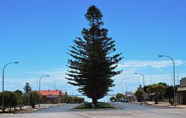
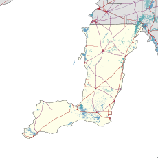
The Yorke Peninsula is a peninsula located north-west and west of Adelaide in South Australia, between Spencer Gulf on the west and Gulf St Vincent on the east. The peninsula is separated from Kangaroo Island to the south by Investigator Strait. The most populous town in the region is Kadina.

Wallaroo is a port town on the western side of Yorke Peninsula in South Australia, 160 kilometres (100 mi) northwest of Adelaide. It is one of the three Copper Triangle towns famed for their historic shared copper mining industry, and known together as "Little Cornwall", the other two being Kadina, about 8 kilometres (5 mi) to the east, and Moonta, about 18 kilometres (11 mi) south. In 2016, Wallaroo had a population of 3,988 according to the census held.

Port Broughton is a small South Australian town located at the northern extent of the Yorke Peninsula on the east coast of Spencer Gulf. It is situated about 170 km north-west of Adelaide, and 56 km south of Port Pirie. At the 2011 census, the town of Port Broughton had a population of 1,034.
Ardrossan is a town in the Australian state of South Australia located on the eastern coast of the Yorke Peninsula, about 150 kilometres (93 mi) by road from the Adelaide city centre. It is notable for its deepwater shipping port and its towering coastal cliffs of red clay.

Port Giles is a port on Yorke Peninsula in the Australian state of South Australia located in the gazetted locality of Coobowie between the towns of Stansbury and Edithburgh.

Moshulu is a four-masted steel barque, built as Kurt by William Hamilton and Company at Port Glasgow in Scotland in 1904. The largest remaining original windjammer, she is currently a floating restaurant docked in Penn's Landing, Philadelphia, adjacent to the museum ships USS Olympia and USS Becuna.

Port Vincent is a small town on the east coast of Yorke Peninsula in South Australia, 194 km from Adelaide by road. At the 2016 census, Port Vincent had a population of 514.

Wool Bay is a locality and a former government town in the Australian state of South Australia on the east coast of southern Yorke Peninsula. It is located between Stansbury and Coobowie on Yorke Peninsula, approximately 220 kilometres from Adelaide by road, but only just over 60 km due west across Gulf St Vincent.
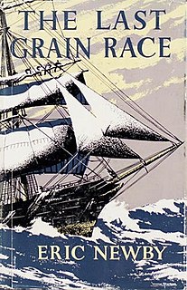
The Last Grain Race is a 1956 book by Eric Newby, a travel writer, about his time spent on the four-masted steel barque Moshulu during the vessel's last voyage in the Australian grain trade.

*This article is about a region in Australia. For coast of County Waterford, Ireland, see Copper Coast (Ireland).

Port Rickaby is a town on the Spencer Gulf coast of Yorke Peninsula in South Australia.

Grain Race or The Great Grain Race was the informal name for the annual windjammer sailing season generally from South Australia's grain ports on Spencer Gulf to Lizard Point, Cornwall on the southwesternmost coast of the United Kingdom, or to specific ports. A good, fast passage Australia-to-England via Cape Horn was considered anything under 100 days.

Price is a town and locality on Yorke Peninsula in South Australia. It is within the Yorke Peninsula Council local government area and is 131 kilometres (81 mi) north west of the centre of state capital, Adelaide.
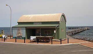
Port Victoria Maritime Museum is a maritime museum in the Australian state of South Australia located on the west coast of Yorke Peninsula in Port Victoria. It is housed in the original general cargo shed which was brought out from England in kit form in 1877 and was erected at the landward end of the jetty. The jetty took seven months to build and was completed in January 1878. Household goods for the early settlers in the town and surrounding farmlands were brought by steamers from Port Adelaide and stored in the cargo shed until the settlers’ homes were completed.

Wardang Island, also known as Waralti is a low-lying 20 km2 island in the Spencer Gulf close to the western coast of the Yorke Peninsula, South Australia. It acts as a natural breakwater, protecting the former grain port of Port Victoria and providing a sheltered anchorage. After European colonisation it was used for the grazing of sheep, for rabbit disease research, was quarried for lime to supply the lead smelter at Port Pirie and is currently leased to the island's traditional owners: the Narungga. The much smaller Goose Island and the other rocks and islets in the Goose Island Conservation Park lie off the northern end. Anyone seeking to visit the island must obtain prior permission from the Point Pearce Community Council.

Port Kembla is a man-made cargo port or artificial harbour, with an outer harbour protected by breakwaters and an inner harbour constructed by dredging, located in the Illawarra region of New South Wales, Australia.
Transport in South Australia is provided by a mix of road, rail, sea and air transport. The capital city of Adelaide is the centre to transport in the state. With its population of 1.4 million people, it has the majority of the state's 1.7 million inhabitants. Adelaide has the state's major airport and sea port.

The Mosquito Fleet was the fleet of small ketches and schooners operating in the shallow coastal and gulf waters of South Australia, from the colony's establishment in 1836 until 1982.
Hardwicke Bay is a bay in the Australian state of South Australia located on the west coast of Yorke Peninsula in Spencer Gulf.