
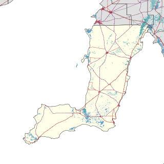
The Yorke Peninsula Council is a local government area in South Australia. Its boundaries include most of the Yorke Peninsula. The council seat is at Maitland; the council also maintains branch offices at Minlaton, Warooka and Yorketown.
Balgowan is a small coastal town on the west coast of South Australia's Yorke Peninsula. It is located approximately 20 kilometres west of Maitland. Like other towns on popular with tourists on Yorke Peninsula, it has a large number of shacks, holiday houses, caravan facilities and a boat ramp. The population generally increases during peak holiday periods.
Moonta Bay is located in the Copper Coast region of Northern Yorke Peninsula South Australia, adjacent to the historic town of Moonta and Port Hughes.

Sultana Point is a locality in the Australian state of South Australia located on the Yorke Peninsula immediately adjoining the western head of Gulf St Vincent about 80 kilometres west of the state capital of Adelaide.
Port Arthur is a locality in the Australian state of South Australia located on the Yorke Peninsula at the northern end of Gulf St Vincent about 100 kilometres north west of the state capital of Adelaide and about 9 kilometres north of the town of Port Wakefield.
Foul Bay is a locality in the Australian state of South Australia located on the south coast of Yorke Peninsula immediately adjoining Investigator Strait about 130 kilometres west of the state capital of Adelaide.
White Hut is a locality in the Australian state of South Australia. It is on the west coast of Yorke Peninsula immediately adjoining Spencer Gulf about 145 kilometres west of the state capital of Adelaide. Its boundaries were created in May 1999. As of 2014, the majority of the land within the locality is zoned as “water protection” to protect groundwater basins present at “shallow depths” and to encourage land use such as “broadacre cropping, grazing, and wind farm and ancillary development.” White Hut is within the federal division of Grey, the state electoral district of Narungga and the local government area of the Yorke Peninsula Council.
Tiddy Widdy Beach is a locality in the Australian state of South Australia located on the east coast of Yorke Peninsula immediately adjoining Gulf St Vincent about 84 kilometres northwest of the Adelaide city centre and about 5 kilometres northeast of the centre of Ardrossan.

James Well is a locality in the Australian state of South Australia located on the east coast of Yorke Peninsula immediately adjoining Gulf St Vincent about 84 kilometres north-west of the state capital of Adelaide and about 5 kilometres of the centre of Ardrossan.
Rogues Point is a locality in the Australian state of South Australia located on the east coast of Yorke Peninsula immediately adjoining Gulf St Vincent, about 80 kilometres north-west of the Adelaide city centre and about 6.9 kilometres of the centre of Ardrossan.
Sheaoak Flat is a locality in South Australia located on the east coast of Yorke Peninsula immediately adjoining Gulf St Vincent about 71 kilometres north-west of the Adelaide city centre.
Nalyappa is a locality in the Australian state of South Australia located on the west coast of Yorke Peninsula immediately adjoining Spencer Gulf about 128 kilometres north-west of the state capital of Adelaide.
Chinaman Wells is a locality in the Australian state of South Australia located on the west coast of Yorke Peninsula immediately adjoining Spencer Gulf about 119 kilometres north-west of the state capital of Adelaide.
North Beach is a locality in South Australia located on the west coast of Yorke Peninsula immediately adjoining Spencer Gulf about 145 kilometres north-west of the Adelaide city centre.
Ward Hill is a locality in the Australian state of South Australia located on the west coast of Yorke Peninsula immediately adjoining Spencer Gulf about 157 kilometres north-west of the Adelaide city centre.
Couch Beach is a locality in the Australian state of South Australia located on the western side of Yorke Peninsula on the portion forming the south coast of Hardwicke Bay in Spencer Gulf about 130 kilometres west of the state capital of Adelaide.
The Pines is a locality in the Australian state of South Australia located on the western side of Yorke Peninsula on the portion forming the south coast of Hardwicke Bay in Spencer Gulf about 131 kilometres west of the Adelaide city centre.
Point Souttar is a locality in the Australian state of South Australia located on the western side of Yorke Peninsula on the portion forming the south coast of Hardwicke Bay in Spencer Gulf about 121 kilometres west of the Adelaide city centre.
Black Point is a locality in the Australian state of South Australia located on the east coast of Yorke Peninsula about 72 kilometres northwest of the state capital of Adelaide.
Bluff Beach is a locality in the Australian state of South Australia located on the west coast of Yorke Peninsula overlooking Hardwicke Bay about 104 kilometres west of the state capital of Adelaide.

