The Port of Goole (also known as Goole Docks and The Port in Green Fields), is a maritime port at the mouth of the Aire and Calder Navigation where it feeds into the River Ouse, in the East Riding of Yorkshire, England. The port opened in 1826, when the Aire and Calder Navigation was completed, connecting to the River Ouse at what is now the town of Goole. The port is one of the Humber Ports, associated with the waterway of the Humber Estuary and its tributaries, and is known to be Britain's largest inland port, being some 50 miles (80km) from the open sea. It has good road and rail transport links, and deals with about £800million worth of trade each year.
Originally the port was in the West Riding of Yorkshire, but was transferred to Humberside in 1974, then it was moved into the East Riding of Yorkshire in 1996.
History
Port of Goole on a target dossier of the German Luftwaffe, 1940
Whilst the location of Goole as a settlement has been around since Anglo-Saxon times,[5] the land surrounding the area of Goole was marshy, and only drained when King Charles I granted Cornelius Vermuyden the right to drain the land and divert the River Don into the Ouse, rather than the Trent.[6] The River Don had hitherto drained eastwards directly into the Trent at Adlingfleet.[7] Prior to the diversion of the River Don (which became known as the Dutch River), and the opening of the Aire and Calder Navigation, Goole itself was a tiny hamlet, on the south bank of the River Ouse.[8] In 1821, five years before the port was opened, the population of Goole was listed as 450; by 1831, it had increased threefold to 1,671. By 1901, the town had grown to 4,549 residents.[9] The port was completed and opened in July 1826, but Goole itself was not recognised legally as a port town until 1828.[10] However, the effect of the township's creation led to it being a point of reference locally. When land was advertised for sale in local newspapers, hamlets in the area were always advertised as being "near Howden..", this changed to being "near Goole."[11]
The proprietors of the canal sought to exploit the increasing coal trade which was being mined further inland in the West Riding of Yorkshire.[12] Prior to the opening of the Aire and Calder Navigation, Selby was the port of transhipment for coal from the West Riding, but by 1828, Goole had supplanted Selby as the exporting hub in the region.[13] In addition to the coal trade, Goole was not only further downriver, but the section of the Ouse between Selby and Goole was beset by several meanders (what Baron Duckham labelled as a "torturous voyage"), which made it harder for larger shipping to navigate.[14] The proprietors of Goole docks were keen to achieve foreign trade status, a desired marque awarded by the Board of Customs. Initially, the comptroller was resistant to this, however, the board was suitably impressed enough by the dock operation to grant the award, much to the consternation of those operating Hull docks.[15] By 1840 Goole was exporting 100,000 tonnes (110,000 tons) of coal each year; four times the amount being shipped out of Hull docks.[16]
Trade through the port suffered during the First World War, the Depression and the Second World War.[17] The reorganisation of the British Ports, a UK government white paper, took effect on 1 January 1963, and Goole became one of 19 ports operated by the British Transport Docks Board across Great Britain.[note 1][18][19] Up until 1974, the port was in the West Riding of Yorkshire, but it was moved into the new county of Humberside.[20] This itself was abolished in 1996, and Goole was moved into the East Riding of Yorkshire.[21]
In 1983, the British Transport Docks Board was wound-up, with all assets being privatised, Goole Docks was acquired by Associated British Ports (ABP).[22] The port was granted Freeport status in 2021, along with the other Humber ports of Grimsby, Hull and Immingham.[23]
Geography
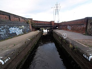
The port is connected at the west end to the Aire and Calder Navigation, with the Dutch River (the new course of the River Don) immediately to the south of the canal, and they run alongside each other to the west for 6 miles (9.7km).[24] Initially, the port only had two locks; Barge Lock (3 acres (1.2ha)) controlled entry into the River Ouse, and Ship Lock (2.75 acres (1.11ha)) was a little further north, connected to the canal end of Barge Dock.[25][26] Despite the small size of both locks, they could hold about 60 ships and 200 barges, and the nascent port was known to be quite efficient at the transshipment of goods.[27] A timber pond was built on the western approach to the dock on the Aire and Calder Navigation, but this was later developed into South Dock.[28] In 1838, the port was expanded by the addition of Ouse Dock (which still exists) and was noted for is width of 58 feet (18m), built to accommodate paddle steamers.[29] In 1845, the Wakefield, Pontefract and Goole Railway, lodged an application to Parliament to build a railway to the docks at Goole, something which the dock proprietors initially resisted, however, the railway was completed in 1848.[30]
In the early days of the port's development, it was called The Port in Green Fields, due to its rural location surrounded by fields. The name was later attributed to Lord Baden-Powell.[31] Between 1826 and 1974, the port was in the West Riding of Yorkshire (the River Ouse being the boundary between the West and East Ridings at that location), making Goole one of only two seaports in the West Riding of Yorkshire (the other being Selby).[32] From 1974 until 1996, the area was administered as part of Humberside's County Council area.[33][34]
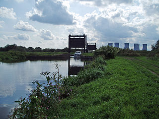
The modern-day port has the A161 link road running through it, which crosses the canal on a swing bridge built in 1899,[35] and over the Dutch River on a swing bridge also.[36] The A161 connects to the M62 motorway on the west side of Goole.[37] Railfreight serves the port in the form of steel exports from Scunthorpe and Rotherham.[38] The port, known to be the largest inland port in Britain, lies some 50 miles (80km) from the sea via the Humber Estuary.[39] The present day docks handle trade worth around £800million each year.[40]
The port has suffered from its lack of deep-water access, in the face of increasing ship sizes. In 2010, it lost a contract with TransAtlantic UK for a thrice-weekly sailing to Sweden which regularly carried 400,000 tonnes (440,000 tons) per annum. The owners of Goole, ABP, retained the contract, but it was moved to the new 10-acre (4ha) terminal at Hull King George Dock. This also involved moving two of the mobile cranes from Aldam Dock to Hull King George Dock by barge, with reputedly only a 9.8-foot (3m) clearance underneath Humber Bridge.[41]
Statistics
The list below, shows the tonnages either unloaded, loaded, or both unloaded and loaded goods in the Port of Goole. Statistics are given in five year intervals, until 2015, when they are displayed yearly.
A sample of the goods loaded and unloaded from 1964 and 1965 shows that the biggest imports were chemicals and chemical fertilisers, with coal being the biggest export from Goole.[note 4][50] Between 1971 and the late 1980s, Goole was an import point for Renault cars. One of the benefits of using Goole for offloading vehicles was its ability to maintain a constant water level, being fed by the Aire and Calder Navigation. This avoided the need for expensive linkspans connecting the shipping vessels with the dockside. However, as mentioned elsewhere, the lack of access for bigger ships killed off this trade.[51] A survey in 1996 detailed that 60% of trade arrived at, or left Goole by road, 35% by water, and only 5% by rail.[52]
Coal was exported through Goole docks from the coalfields of West and South Yorkshire until 1986. The system used was a powered tug with several small coal barges pulled behind, with the coal-carrying barges being known as Tom Puddings. Each barge typically held between 35 tonnes (39 tons) and 40 tonnes (44 tons) of coal, and the trips were organised with up to 19 barges in the consist.[53][54] This system had been developed by W.H. Bartholomew in an effort to stop the coal trade being monopolised by the railways, with the first hoist being opened in the late 1860s.[55] Exports reached in peak in 1953, when over 2,448,000 tonnes (2,698,000 tons) of coal was exported, accounting for 94% of the tonnage through Goole docks.[56] In 1976, between 230,000 tonnes (250,000 tons) and 250,000 tonnes (280,000 tons) of coal were exported through the docks via inland water transport on the Tom Pudding barges.[57]
The coal trade brought in by Tom Pudding barges ceased in 1986.[58]
Coal was also exported by rail, usually from Stanhope dock.[59]
Containerisation
The docks at Goole branched out into handling containers, most usually on short-sea services to other parts of the UK or Northern Europe. Containers were handled at Aldam Dock, and in 1984, £500,000 was spent on a new container facility.[60][61] The peak year for the trans-shipment of containers came in 2001, when over 128,000 TEUs were handled at the dock. Since then, volumes have dropped, a decline attributed to larger ships for the container transport lines, which cannot access the port at Goole.[62][63] A study in 2011, identified that of the Humber Ports (Goole, Grismby, Hull and Immingham), Goole only handled around 15% of the container trade, roughly 67,500 TEUs, although by 2012, it was only handling a 1,000 TEUs on average per year.[64][62]
The modern day port consists of eight docks and two dry docks. Boats can enter from the north-east via Victoria Lock and Ouse Lock, or via the south-east via Ocean Lock.[67] The port has a complement of 20 berths with a maximum draft of 5.5 metres (18ft). The length of vessels entering the dock cannot exceed 100 metres (330ft).[68] The draft is constant and not affected by the tides as water is supplied from the Aire and Calder Canal.[69][70] Because the port was not planned as one system but constructed over a period of several decades, the layout makes ship movement difficult: a ship bound for the West Dock needs to make two ninety-degree turns if it enters through the Ouse Dock, or three if via the Ocean Lock. The acreage and opening dates of each dock are listed below:[71][72]
Aldam Dock – 2.5 acres (1ha), 1882
Barge Dock – 3.75 acres (1.52ha), 20 July 1826
Ouse Dock – 5 acres (2ha), 1838
Railway Dock – 4.5 acres (1.8ha), 1846
Ship Dock – 3.5 acres (1.4ha), 20 July 1826
South Dock – 5.5 acres (2.2ha), 1910
Stanhope Dock – 3.75 acres (1.52ha), 1891
West Dock – 7 acres (2.8ha), 1912
The total length of quaysides is three miles (4.8km).[73] Additionally, storage space on the dock, both in warehouses and open storage, covers in excess of 480,000 square feet (45,000m2).[74] The port has two dry docks, no. 1 being on the eastern side of the Ouse Dock and no. 2 being on the southern side of the South Dock. It historically had three, but No. 3 dry dock, which lay on the northern side of the Barge Dock, has been infilled and covered with warehousing. A proposed Central Dock, between the West and South Docks and reached from the latter, was never built.[75][76]
Listed buildings
Salt and Pepper, Goole
Several buildings within the dock estate are listed with Historic England, most because of their association with the transportation of coal.
Brick Water Tower.[78] This was built in 1885 to hold 30,000 imperial gallons (140,000L; 36,000USgal). The replacement tower, which can hold 750,000 imperial gallons (3,400,000L; 900,000USgal), was built in 1927.[79] These two adjacent structures are prominent on the skyline, and are known locally as the "Salt and Pepper Pot".[80][81]
Coal Wagon Hoist, Adjoining Railway Approach and Control Boxes - a hoist to transfer coal from railway wagons into ships.[82]
↑ The other 18 were; Ayr, Barrow, Barry, Cardiff, Fleetwood, Garston, Grimsby, Hull, Immingham, King's Lynn, Lowestoft, Newport, Plymouth (Millbay), Port Talbot, Silloth, Southampton, Swansea, and Troon
↑ Trade through the port was curtailed because of the Second World War.[46]
↑ Trade through the port was curtailed because of the Second World War.[46]
↑ In fact, coal exports accounted for 90.25% of exports from Goole (1,528,961 tonnes (1,685,391 tons)) in comparison to all other commodities added together (165,727 tonnes (182,683 tons)).
Related Research Articles
The River Ouse is a river in North Yorkshire, England. Hydrologically, the river is a continuation of the River Ure, and the combined length of the River Ure and River Ouse makes it, at 129 miles (208 km), the sixth-longest river of the United Kingdom and the longest to flow entirely in one county. The length of the Ouse alone is about 52 miles (84 km) but the total length of the river is disputed.
The Aire and Calder Navigation is the canalised section of the Rivers Aire and Calder in West Yorkshire, England. The first improvements to the rivers above Knottingley were completed in 1704 when the Aire was made navigable to Leeds and the Calder to Wakefield, by the construction of 16 locks. Lock sizes were increased several times, as was the depth of water, to enable larger boats to use the system. The Aire below Haddlesey was bypassed by the opening of the Selby Canal in 1778. A canal from Knottingley to the new docks and new town at Goole provided a much shorter route to the River Ouse from 1826. The New Junction Canal was constructed in 1905, to link the system to the River Don Navigation, by then part of the Sheffield and South Yorkshire Navigation.
The Sheffield and South Yorkshire Navigation (S&SY) is a system of navigable inland waterways in South Yorkshire and Lincolnshire, England.
The East Riding of Yorkshire, often abbreviated to the East Riding or East Yorkshire, is a ceremonial county in the Yorkshire and the Humber region of England. It borders North Yorkshire to the north and west, South Yorkshire to the south-west, and Lincolnshire to the south across the Humber Estuary. The city of Kingston upon Hull is the largest settlement.
Goole is a port town and civil parish on the River Ouse in the East Riding of Yorkshire, England. The town's historic county is the West Riding of Yorkshire.
The canals of the United Kingdom are a major part of the network of inland waterways in the United Kingdom. They have a varied history, from use for irrigation and transport, through becoming the focus of the Industrial Revolution, to today's role of recreational boating. Despite a period of abandonment, today the canal system in the United Kingdom is again increasing in use, with abandoned and derelict canals being reopened, and the construction of some new routes. Canals in England and Wales are maintained by navigation authorities. The biggest navigation authorities are the Canal & River Trust and the Environment Agency, but other canals are managed by companies, local authorities or charitable trusts.
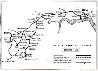
The Hull Barnsley & West Riding Junction Railway and Dock Company (HB&WRJR&DCo.) was opened on 20 July 1885. It had a total projected length of 66 miles but never reached Barnsley, stopping a few miles short at Stairfoot. The name was changed to The Hull and Barnsley Railway (H&BR) in 1905. Its Alexandra Dock in Hull opened 16 July 1885.
Airmyn is a village and civil parish in the East Riding of Yorkshire, England. It is situated at the mouth of the River Aire with the River Ouse, approximately 2 miles (3.2 km) north-west of Goole. It lies to the west of the M62 motorway and the A614 road. According to the 2011 UK census, Airmyn parish had a population of 768, a fall from the 2001 UK census figure of 795. The parish covers an area of 1,155.353 hectares.
The New Junction Canal is a canal in South Yorkshire, England. It is part of the Sheffield and South Yorkshire Navigation (S&SYN), although it was jointly funded by the Aire and Calder Navigation and was opened in 1905. It links the River Don Navigation and the Stainforth and Keadby Canal with the Aire and Calder Navigation. It is straight and was the last canal built in England for commercial purposes.
The Stainforth and Keadby Canal is a navigable canal in South Yorkshire and Lincolnshire, England. It connects the River Don Navigation at Bramwith to the River Trent at Keadby, by way of Stainforth, Thorne and Ealand, near Crowle. It opened in 1802, passed into the control of the River Don Navigation in 1849, and within a year was controlled by the first of several railway companies. It became part of the Sheffield and South Yorkshire Navigation, an attempt to remove several canals from railway control, in 1895. There were plans to upgrade it to take larger barges and to improve the port facilities at Keadby, but the completion of the New Junction Canal in 1905 made this unnecessary, as Goole could easily be reached and was already a thriving port.
Beverley Beck is a short canal in the East Riding of Yorkshire, England. The beck runs from Grovehill Lock on the River Hull at Beverley west for about 0.8 miles (1.3 km) into the town of Beverley. Until 1802, the beck was tidal, but the Beverley and Barmston Drain needed to pass under it, and the lock was constructed to maintain water levels over its tunnel. In 1898, a steam engine was installed, which could be used to top up the water levels in the beck by pumping water from the River Hull. A multimillion-pound refurbishment of the area concluded in 2007, with the refurbishment of the lock gates and pumping engine.
The Port of Hull is a port at the confluence of the River Hull and the Humber Estuary in Kingston upon Hull, in the East Riding of Yorkshire, England.
The Selby Canal is a 6-mile (9.7 km) canal with two locks, which bypasses the lower reaches of the River Aire in Yorkshire, England, from the village of West Haddlesey to the town of Selby where it joins the River Ouse. It opened in 1778, and provided the main outlet for the Aire and Calder Navigation until 1826, when it was bypassed by a new cut from Ferrybridge to Goole. Selby steadily declined after that, although traffic to York still used the canal.
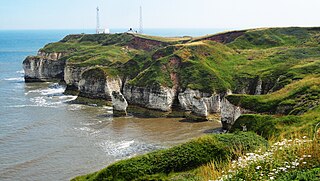
In Yorkshire there is a very close relationship between the major topographical areas and the geological period in which they were formed. The Pennine chain of Hills in the west is of Carboniferous origin. The central vale is Permo-Triassic. The North York Moors in the north-east of the county are Jurassic in age while the Yorkshire Wolds to the south east are Cretaceous chalk uplands. The plain of Holderness and the Humberhead levels both owe their present form to the Quaternary ice ages.
The Port of Immingham, also known as Immingham Dock, is a major port on the east coast of England, located on the south bank of the Humber Estuary in the town of Immingham, Lincolnshire. In 2019, the Port of Grimsby & Immingham was the largest port in the United Kingdom by tonnage with 54.1 million tonnes of cargo passing through that year.
William Hamond Bartholomew was an engineer in West Yorkshire, England who was responsible for the expansion of the Aire and Calder Navigation in the 19th century and invented a number of improvements in coal-handling which led to the expansion of Goole as one of the largest exporters of coal in the country.
Henry Scarr Ltd. was an English shipbuilding company based in the East Riding of Yorkshire at Hessle on the Humber. Henry Scarr took over an existing shipyard in 1897, and continued to build ships there until 1932, when the site was bought by Richard Dunston Ltd. Dunstons operated the shipyard until 1974, and after a series of takeovers, shipbuilding ceased in 1994.
The Goole Steam Shipping Company was a company based in Goole, England from 1864 to 1905 which operated steamship services from Goole to northern European ports.
Boothferry Bridge is a crossing over the River Ouse, in the East Riding, England, some 2 miles (3.2 km) north-west of Goole. The bridge was opened in 1929, replacing a ferry crossing immediately west of the bridge's location. The Act of Parliament for the building of the bridge in 1925, gave priority to river traffic. This situation still exists, though there have been some attempts to change priorities. On opening, it was the furthest crossing downstream of the river, cutting 25 miles (40 km) off the journey south to London from Kingston upon Hull. The M62 Ouse Bridge opened up to the east of Boothferry Bridge in 1976.
Bawtry Wharf was a small Medieval port in the town of Bawtry, West Riding of Yorkshire, England. The port operated from a wharf on the River Idle, a small body of water that flowed eastwards inland from Bawtry to the River Trent, and was navigable to sailing ships. Bawtry Wharf flourished as a port from the 12th century until the middle of the 19th century. Whilst the port was in a decline by the early 19th century, the building of a railway viaduct near the town necessitated diverting the River Idle which isolated the port from the main river stem, and the site silted up after losing its water.
↑ Mitchinson, James, ed. (6 December 2022). "Lost images of days gone by – in the port that's 50 miles from the sea". The Yorkshire Post. p.9. ISSN0963-1496.
↑ Ford, I (1991). Ports into the next century: proceedings of the conference UK ports 2000 organized by the Institution of Civil Engineers and held in Hull on 17–18 October 1990. London: Thomas Telford. p.126. ISBN0-7277-1619-0.
↑ Hill, Peter (30 December 1976). "State boards clash over 25pc rise in port's charge for handling coal". The Times. No.59897. p.14. ISSN0140-0460.
↑ Pratt, Derek (2012). Urban waterways: a window on to the waterways of England's towns and cities. London: Adlard Coles Nautical. p.46. ISBN978-1408140277.
150 years of the Port of Goole. Goole: British Transport Docks Board. 1976. OCLC642487296.
Duckham, Baron F. (1967). The Yorkshire Ouse: the history of a river navigation. Newton Abbot: David & Charles. OCLC5352125.
East, W.G. (May 1931). "The Port of Kingston-upon-Hull during the Industrial Revolution". Economica (32). London: The London School of Economics and Political Science: 190–212. doi:10.2307/2547923. ISSN0013-0427. JSTOR2547923.
Fell, Mike G. (2016). An illustrated history of the Port of Goole and its railways. Clophill, Bedfordshire: Irwell Press. ISBN978-1-906919-82-5.
These are in the ceremonial county of North Yorkshire, but they are in the North-East England region.
This page is based on this Wikipedia article Text is available under the CC BY-SA 4.0 license; additional terms may apply. Images, videos and audio are available under their respective licenses.