The Porte Saint-Denis was originally a gateway through the Wall of Charles V that was built between 1356 and 1383 to protect the Right Bank of Paris. The medieval fortification had two gates and was surmounted with four towers. Additional portcullises defended the outer gate along with a drawbridge and rock-cut ditch. However, with the advent of gunpowder and the development of cannons and bombards, the walls were eventually partly torn down in the 1640s to make way for the larger and more fortified Louis XIII Wall. In the 1670s, the remaining walls of Charles V were entirely demolished when Paris spread beyond the confines of its medieval boundaries.
A monument defining the official art of its epoque, the Porte Saint-Denis provided the subject of the engraved frontispiece to Blondel's influential Cours d'architecture, 1698.[1] It was restored in 1988.
The Porte Saint-Denis is a triumphal arch inspired by the Arch of Titus in Rome. The monument is 24.65m (80.9ft) high, 25m (82ft) wide, and 5m (16ft) deep. The arch itself is 15.35m (50.4ft) high in the center and 8m (26ft) across.
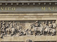
The main arch is flanked by obelisks applied to the wall face bearing sculptural groups of trophies of arms. Above the main arch, the southern face carries a sculptural group by Michel Anguier of "The Passage of the Rhine" in a sunk panel, while the north face carries allegorical figures of the Rhine and the Netherlands. The entablature bears the gilded bronze inscription LUDOVICO MAGNO, "To Louis the Great". Two smaller pedestrian walkways were built through the obelisk pedestals but they have now been closed.
The Arc de Triomphe de l'Étoile is one of the most famous monuments in Paris, France, standing at the western end of the Champs-Élysées at the centre of Place Charles de Gaulle, formerly named Place de l'Étoile—the étoile or "star" of the juncture formed by its twelve radiating avenues. The location of the arc and the plaza is shared between three arrondissements, 16th, 17th (north), and 8th (east). The Arc de Triomphe honours those who fought and died for France in the French Revolutionary and Napoleonic Wars, with the names of all French victories and generals inscribed on its inner and outer surfaces. Beneath its vault lies the Tomb of the Unknown Soldier from World War I.
A triumphal arch is a free-standing monumental structure in the shape of an archway with one or more arched passageways, often designed to span a road. In its simplest form a triumphal arch consists of two massive piers connected by an arch, crowned with a flat entablature or attic on which a statue might be mounted or which bears commemorative inscriptions. The main structure is often decorated with carvings, sculpted reliefs, and dedications. More elaborate triumphal arches may have multiple archways.
Strasbourg–Saint-Denis is a station on Line 4, Line 8 and Line 9 of the Paris Métro. Opened in 1908 under the name Boulevard Saint-Denis, it takes its current name in 1931, which refers to Rue Saint-Denis and the Boulevard de Strasbourg.
The Arc de Triomphe du Carrousel is a triumphal arch in Paris, located in the Place du Carrousel. It is an example of Neoclassical architecture in the Corinthian order. It was built between 1806 and 1808 to commemorate Napoleon's military victories in the Wars of the Third and Fourth Coalitions. The Arc de Triomphe de l'Étoile, at the far end of the Champs Élysées, was designed in the same year; it is about twice the size and was not completed until 1836.
François and Michel Anguier (1612–1686) were two French brothers and sculptors.
The Narva Triumphal Arch was erected in the vast Stachek Square, Saint Petersburg, in 1814 to commemorate the Russian victory over Napoleon.
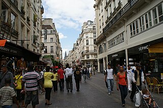
Rue Saint-Denis is one of the oldest streets in Paris. Its route was first laid out in the 1st century by the Romans, and then extended to the north in the Middle Ages. From the Middle Ages to the present day, the street has been notorious as a place of prostitution. Its name derives from it being the historic route to Saint-Denis.
Porte d'Aix is a triumphal arch in Marseille, in the south of France, marking the old entry point to the city on the road from Aix-en-Provence. The classical design by Michel-Robert Penchaud was inspired by the triumphal arches of the Roman Empire. The Porte d’Aix was initially conceived in 1784 to honour Louis XVI and to commemorate the Peace of Paris (1783) that ended the American Revolutionary War. Following the restoration of the Bourbon monarchy in 1814-15, the project was resumed in 1823, now to commemorate French victories in the Spanish Expedition, notably at the Battle of Trocadero, August 31, 1823. It was eventually completed in 1839, with a more general theme of victory.
The Porte Saint-Martin is a Parisian monument located at the site of one of the gates of the now-destroyed fortifications of Paris. It is located at the crossing of Rue Saint-Martin, Rue du Faubourg Saint-Martin and the grands boulevards Boulevard Saint-Martin and Boulevard Saint-Denis.
The Boulevards of Paris are boulevards which form an important part of the urban landscape of Paris. The boulevards were constructed in several phases by central government initiative as infrastructure improvements, but are very much associated with strolling and leisurely enjoyment in the minds of Parisians.
The Place de la Nation is a circle on the eastern side of Paris, between Place de la Bastille and the Bois de Vincennes, on the border of the 11th and 12th arrondissements.
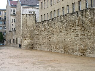
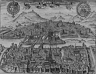
The Walls of Paris refers to the city walls that surrounded Paris, France, as it grew from ancient times until the 20th century, built primarily to defend the city but also for administrative reasons. Several successive city walls were built over the centuries, either adding to existing walls or replacing demolished ones, through 1846, when construction of the Thiers wall was completed. The city walls of Paris include:
The Wall of Philip Augustus is the oldest city wall of Paris (France) whose plan is accurately known. Partially integrated into buildings, more traces of it remain than of the later fortifications.
The wall of Charles V, built from 1356 to 1383 is one of the city walls of Paris. It was built on the right bank of the river Seine outside the wall of Philippe Auguste. In the 1640s, the western part of the wall of Charles V was demolished and replaced by the larger Louis XIII wall, with the demolished material reused for the new wall. This new enclosure (enceinte) was completely destroyed in the 1670s and was replaced by the Grands Boulevards.
Notre-Dame-de-Bonne-Nouvelle, located at 25 Rue de la Lune, in the 2nd arrondissement of Paris and is a Catholic parish church built between 1823 and 1830. It is dedicated to Notre-Dame de Bonne-Nouvelle, referring to the Annunciation. The neighbourhood of Bonne-Nouvelle, the Boulevard de Bonne-Nouvelle and the Bonne Nouvelle metro station are named after it.
The Porte Saint-Antoine was one of the gates of Paris. There were two gates named the Porte Saint-Antoine, both now demolished, of which the best known was that guarded by the Bastille, on the site now occupied by the start of Rue de la Bastille in the 4th arrondissement of Paris.
This article presents the main landmarks in the city of Paris within administrative limits, divided by its 20 arrondissements. Landmarks located in the suburbs of Paris, outside of its administrative limits, while within the metropolitan area are not included in this article.
The Ramparts of Senlis are located in Senlis (Oise), capital of the Oise arrondissement in France. They consist of the Gallo-Roman city walls and medieval ramparts proper.
The following outline is provided as an overview of and topical guide to Paris:
The Arc Héré or Porte Héré is a triumphal arch located in the city of Nancy, France, on the north side of the Place Stanislas. It was designed by Emmanuel Héré de Corny to honor the French king Louis XV and was built between 1752 and 1755. Its architecture is inspired by the Arch of Septimius Severus in Rome. The Arc replaced an older royal gate constructed under the rule of Louis XIV; three bas reliefs from the old gate are featured on the Arc.
This page is based on this Wikipedia article Text is available under the CC BY-SA 4.0 license; additional terms may apply. Images, videos and audio are available under their respective licenses.