
Suriname, officially the Republic of Suriname, is a country in northern South America, sometimes considered part of the Caribbean and the West Indies. Situated slightly north of the equator, over 90% of its territory is covered by rainforests, the highest proportion of forest cover in the world. Suriname is bordered by the Atlantic Ocean to the north, French Guiana to the east, Guyana to the west, and Brazil to the south. It is the smallest country in South America by both population and territory, with around 612,985 inhabitants in an area of approximately 163,820 square kilometers. The capital and largest city is Paramaribo, which is home to roughly half the population.

As part of the foreign relations of Suriname, the country is a participant in numerous international organizations.
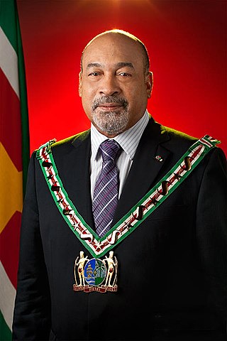
Desiré Delano Bouterse is a Surinamese military officer, politician, convicted murderer and drug trafficker who served as President of Suriname from 2010 to 2020. From 1980 to 1987, he was Suriname's de facto leader after conducting a military coup and establishing a period of military rule. In 1987, Bouterse founded the National Democratic Party (NDP). On 25 May 2010, Bouterse's political alliance, the Megacombinatie, which included the NDP, won the parliamentary elections, and on 19 July 2010, Bouterse was elected as President of Suriname with 36 of 50 parliament votes. He was inaugurated on 12 August 2010.

The Guianas, also spelled Guyanas or Guayanas, is a region in north-eastern South America. Strictly, the term refers to the three Guyanas: Guyana, Suriname and French Guiana, formerly British, Dutch and French Guyana. Broadly it refers to the South American coast from the mouth of the Oronoco to the mouth of the Amazon.
The education in Suriname was initially set up in analogy to the Dutch education system. In terms of structure, the education system is now a mixture of school types that were common in the Netherlands before, during and after the Mammoetwet. The language of instruction is Dutch; mainly Surinamese Dutch. The four exceptions to this rule are the International Academy of Suriname, administered by a local Christian foundation, Christian Liberty Academy, administered by the Caribbean Christian Ministries, and the AlphaMax Academy, a private nonsectarian school administered by the AlphaMax Foundation, and since 2011 Suriname International School, which provides k12 online school for high school students.
Hogg Island, is the largest of the hundreds of islands in the Essequibo River in Guyana, it is located just 5 km from the river's mouth in its estuary into the Atlantic Ocean.
The Central Bank of Suriname (CBvS) is Suriname’s highest monetary authority and the country’s governing body in monetary and economic affairs.

The Surinamese passport is issued to citizens of Suriname for international travel. The passport is a Caricom passport as Suriname is a member of the Caribbean Community.
Belgium began using national postage stamps on 8 July 1849, when two imperforate stamps, a 10c. brown and 20c. blue, collectively known as Epaulettes, were introduced. A few months later a 40c. red stamp with a new design was issued, for postage to foreign destinations. In 1850 two new stamps of 10c. and 20c. were issued.

The Surinamese Interior War was a civil war waged in the Sipaliwini District of Suriname between 1986 and 1992. It was fought by the Tucayana Amazonas led by Thomas Sabajo and the Jungle Commando led by Ronnie Brunswijk, whose members originated from the Maroon ethnic group, against the National Army led by then-army chief and de facto head of state Dési Bouterse.

This is a survey of the postage stamps and postal history of the Netherlands.
The three public bodies of Bonaire, Sint Eustatius and Saba started issuing postal stamps after the dissolution of the Netherlands Antilles in 2010. The islands form a separate postage region under the name Caribisch Nederland .

The Ndyuka people or Aukan people (Okanisi), are one of six Maroon peoples in the Republic of Suriname and one of the Maroon peoples in French Guiana. The Aukan or Ndyuka speak the Ndyuka language. They are subdivided into the Opu, who live upstream of the Tapanahony River in the Tapanahony resort of southeastern Suriname, and the Bilo, who live downstream of that river in Marowijne District.

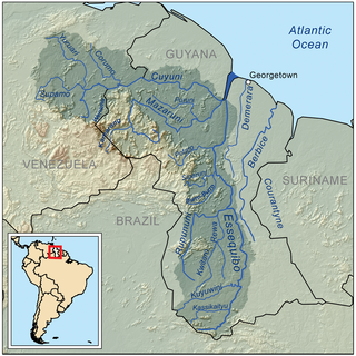
The borders of Suriname consist of land borders with three countries: Guyana, Brazil, and France. The borders with Guyana and France are in dispute, but the border with Brazil has been uncontroversial since 1906.

This is a survey of the postage stamps and postal history of the Netherlands East Indies, otherwise known as the Dutch East Indies, and which today is known as Indonesia.

Surpost, the Suriname Postal Corporation, is the national post office of Suriname.

The Tigri Area is a wooded area that has been disputed by Guyana and Suriname since around 1840. It involves the area between the Upper Corentyne River, the Coeroeni River, and the Kutari River. This triangular area is known as the New River Triangle in Guyana. In 1969 the conflict ran high on, and since then it has been controlled by Guyana and claimed by Suriname. In 1971, both governments agreed that they would continue talks over the border issue and withdraw their military forces from the disputed triangle. Guyana has never held upon this agreement.

The African territories of Ruanda and Urundi came under Belgian control as Ruanda-Urundi after they were seized from Germany during World War I in 1916. They had previously formed part of German East Africa.

The nations of Mexico and Suriname established diplomatic relations in 1975. Both nations are members of the Association of Caribbean States, Community of Latin American and Caribbean States, Organization of American States and the United Nations.
Nationale Top 40 Suriname is a weekly record chart in Suriname. It is updated every Thursday by the Natio40 Foundation.
