Related Research Articles

East Greenwich is a town and the county seat of Kent County, Rhode Island. The population was 14,312 at the 2020 census. East Greenwich is the wealthiest municipality within the state of Rhode Island. It is part of the Providence metropolitan statistical area and the Greater Boston combined statistical area.

Warwick is a city in Kent County, Rhode Island, United States, and is the third-largest city in the state, with a population of 82,823 at the 2020 census. Warwick is located approximately 12 miles (19 km) south of downtown Providence, Rhode Island, 63 miles (101 km) southwest of Boston, Massachusetts, and 171 miles (275 km) northeast of New York City.

South Kingstown is a town in, and the county seat of, Washington County, Rhode Island, United States. The population was 31,931 at the 2020 census. South Kingstown is the second largest town in Rhode Island by total geographic area, behind New Shoreham, and the third largest town in Rhode Island by geographic land area, behind Exeter and Coventry.

Narragansett Bay is a bay and estuary on the north side of Rhode Island Sound covering 147 square miles (380 km2), 120.5 square miles (312 km2) of which is in Rhode Island. The bay forms New England's largest estuary, which functions as an expansive natural harbor and includes a small archipelago. Small parts of the bay extend into Massachusetts.
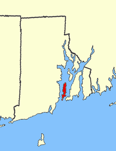
Conanicut Island is an island in Narragansett Bay in the American state of Rhode Island. The second-largest in the Bay, it is connected on the east to Newport on Aquidneck Island by the Claiborne Pell Bridge, commonly known as the Newport Bridge, and on the west to North Kingstown on the mainland via the Jamestown-Verrazano Bridge. The town of Jamestown comprises the entire island. The U.S. Census Bureau reported a land area of 24.46 km2 (9.44 sq mi) and a population of 5,622 in 2000. A tombolo connects the southern part of Conanicut to an extension of the island to the southwest.

Apponaug is a neighborhood in central Warwick, Rhode Island, United States, situated on Apponaug Cove, a tributary to Greenwich Bay and nearby Narragansett Bay. The name Apponaug is a derivation of the Narragansett Indian word for "place of oysters". Indeed, Apponaug Cove holds one of the richest shellfish beds in the United States and was densely populated by the Narragansett people for many centuries prior to the arrival of European settlers.
Cowesett is a hillside neighborhood located in Warwick, Rhode Island.

Davisville, in Washington County, is a village in the town of North Kingstown in the U.S. state of Rhode Island that was formerly the home of the Davisville Naval Construction Battalion Center, which housed the United States Navy's SeaBees.

Rhode Island's 2nd congressional district is a congressional district in southern and western Rhode Island. The district is currently represented by Democrat Seth Magaziner, who has represented the district since January 2023.
The Potowomut River is a tidal extension of the Hunt River in the U.S. state of Rhode Island. It runs approximately 2.5 miles (4.0 km).
The Maskerchugg River is a river in the U.S. state of Rhode Island. It flows approximately 4 miles (6.4 km).
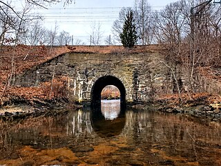
The Hunt River is a river in the U.S. state of Rhode Island. It flows approximately 11 km (7 mi). There is a small stone dam just upstream from the Davisville Road bridge that powered a woolen mill active in the period 1811–1924.

Chepiwanoxet is a neighborhood in Warwick, Rhode Island, with an island peninsula in Greenwich Bay, an arm of Narragansett Bay. The neighborhood straddles the Amtrak railroad lines, which lies just east of and parallel to the Post Road. Its boundaries are Neptune Street to the North, Alger Avenue to the South, Post Road to the West, and Greenwich Bay to the East. Chepiwanoxet Way, an underpass beneath the Amtrak lines, now serves as the only street access in and out of the neighborhood.
Greene Island is a small island in Narragansett Bay, Warwick, Rhode Island. The island was named after Captain John Greene who purchased the island in 1642 from Native Americans as part of a larger purchase of 660 acres around Occupaspatuxet Cove. Occupaspatuxet means where “meadows cut through by a river,” and the area was also known as Greene's Hold. Chief Miantonomi was one of the Indian witnesses on the deed to Greene, which referenced the "little island." The Greenes were followers of Samuel Gorton, a radical Christian philosopher and theologian, who sought refuge in the Warwick area. Greene Island features shallow tidal flats and marsh grasses.
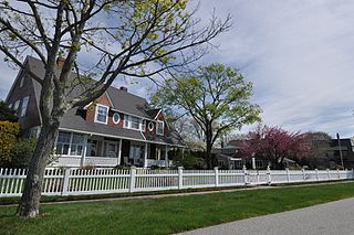
Buttonwood Beach Historic District is a historic district bounded by Brush Neck Cove, Greenwich Bay, Cooper and Promenade Avenues in Warwick, Rhode Island. Buttonwood Beach is a bucolic neighborhood on the eastern limb of the Nausauket neck, located in the West Bay area of Warwick, Rhode Island. Buttonwoods is delimited by Nausauket and Apponaug to the west, Buttonwoods Cove to the north, Greenwich Bay to the south and Oakland Beach to the east. Buttonwood Beach was founded as a summer colony in 1871 by the Rev. Moses Bixby of Providence's Cranston Street Baptist Church, who was looking for a place to establish a summer colony by the shore for his congregation. He envisioned a community that would be similar to Oak Bluffs on Martha's Vineyard, where the Methodists established a summer campground in 1835. Today, this coastal neighborhood on Greenwich Bay is home to people from many different religious backgrounds.

Jerusalem is a fishing village within the town of Narragansett, Rhode Island, on Point Judith. It is across the harbor from Galilee, Rhode Island. It is named after the Biblical city of Jerusalem. Jerusalem is not attached to any other part of Narragansett by land; its only land border is with the Matunuck section of South Kingstown, Rhode Island. Although Jerusalem is not in the Town of South Kingstown, fire and police service in Jerusalem is provided by South Kingstown.

Washington County, known locally as South County, is a county located in the U.S. state of Rhode Island. As of the 2020 census, the population was 129,839. Rhode Island counties have no governmental functions other than as court administrative boundaries, which are part of the state government.

Goddard Memorial State Park is a public recreation area occupying 490 acres (200 ha) along the shores of Greenwich Cove and Greenwich Bay in Warwick, Rhode Island. The state park grounds were once the estate of Civil War officer and Rhode Island politician Robert Goddard, whose children gave the land to the state in 1927 as a memorial to their father. The park features a nine-hole golf course, an equestrian area with 18 miles (29 km) of bridle trails, swimming beach, canoeing area, picnicking facilities, game fields, and a performing arts center.
The Narragansett Runestone, also known as the Quidnessett Rock, is a 2.5 t (2,500 kg) slab of metasandstone located in Rhode Island, United States. It is inscribed with two rows of symbols, which some have indicated resemble ancient runic characters.
References
- ↑ Farzan, Antonia Noori. "Rhode Island pronunciation guide: 35 names that visitors and even some locals get wrong". The Providence Journal. Retrieved July 4, 2024.
- ↑ "Warwick Police Department". www.warwickpd.org.