Related Research Articles

Point Judith is a village and a small cape, on the coast of Narragansett, Rhode Island, on the western side of Narragansett Bay where it opens out onto Rhode Island Sound. It is the location for the year-round ferry service that connects Block Island to the mainland and contains the fishing hamlet of Galilee, Rhode Island.

Aquidneck Island, also known by its former name Rhode Island, is an island in Narragansett Bay in the state of Rhode Island. The total land area is 97.9 km2 (37.8 sq mi), which makes it the largest island in the bay. The 2000 United States Census reported its population as 60,870.
Conanicut Island is the second-largest island in Narragansett Bay in the American state of Rhode Island. It is connected on the east to Newport on Aquidneck Island via the Claiborne Pell Bridge, commonly known as the Newport Bridge, and on the west to North Kingstown on the mainland via the Jamestown-Verrazano Bridge. The town of Jamestown comprises the entire island. The U.S. Census Bureau reported a land area of 24.46 km2 (9.44 sq mi) and a population of 5,622 in 2000.
Prudence Island is the third-largest island in Narragansett Bay in the state of Rhode Island and part of the town of Portsmouth, Rhode Island, United States. It is located near the geographical center of the bay. It is defined by the United States Census Bureau as Block Group 3, Census Tract 401.03 of Newport County, Rhode Island. As of the 2010 census, the population was 278 people living on a land area of 14.43 km2.
Narragansett Bay divides the state of Rhode Island into two parts. The term East Bay refers to communities on the east side of the bay, including Bristol, Warren, Barrington, Tiverton, Little Compton, Newport, Middletown, Portsmouth and Jamestown. The term West Bay refers to communities on the west side of the bay, such as Warwick, Cranston and East Greenwich. Jamestown and the towns on Aquidneck Island are sometimes known as "The Islands" along with Block Island.

Wickford is a small village in the town of North Kingstown, Rhode Island, United States, which is named after Wickford in Essex, England. Wickford is located on the west side of Narragansett Bay, just about a 20-minute drive across two bridges from Newport, Rhode Island. The village is built around one of the most well-protected natural harbors on the eastern seaboard, and features one of the largest collections of 18th century dwellings to be found anywhere in the northeast. Today the majority of the village's historic homes and buildings remain largely intact upon their original foundations.
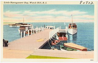
Little Narragansett Bay is an inlet of the Atlantic Ocean and an estuary of the Pawcatuck River on the Rhode Island-Connecticut state line. It is sheltered by a curving peninsula, known as Napatree Point.

Hope Island is a 91-acre (0.368 km²) island located in Narragansett Bay in the State of Rhode Island. It is part of the Narragansett Bay National Estuarine Research Reserve, along with nearby Prudence Island and Patience Island, and home to colonial wading birds during their nesting season of spring and summer.
Dyer Island is an island in Narragansett Bay in Rhode Island, United States. It lies off the west coast of Aquidneck Island and is part of Melville CDP, which itself is part of the town of Portsmouth. The island lies between Melville and Prudence Island and is uninhabited and has a land area of 0.12 km² and is only 13 feet above sea level.

Hog Island is an American island in Narragansett Bay in Rhode Island. It lies at the entrance to the harbor of Bristol and is part of the town of Portsmouth. The 60 ft (18 m) tall Hog Island Shoal Lighthouse stands off the south end, warning ships of the dangerous shoals around the island. It has a land area of approximately 0.3 sq mi, making it the fifth-largest island in Narragansett Bay. It is home to a small summer vacation colony, with no regular year-round residents, and there are approximately 100 homes on it.

Fox Island is an island in Narragansett Bay, Rhode Island, in the United States of America. It lies between Conanicut Island and North Kingstown just south of the village of Wickford, Rhode Island. The island is a part of the town of North Kingstown. The Native Americans called the island "Nanaquonset" The island was purchased from Native Americans by Randall Holden and Samuel Gorton in 1659. In the 1860s a Christian preacher named Captain Jimmie Hammond became the first full-time resident of the island where he lived with his chickens and cat. In 1880, Rev. William Pendleton Chapman, a pastor at the nearby Quidnessett Church, featured the island in his adventure book titled “Budd Boyd’s Triumph: The Boy Firm of Fox Island.” Various other private owners have owned the island since its first habitation. Since 2000 it has been privately owned by a corporation which uses a large wind generator on the east side of the island.

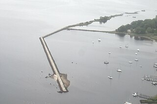
Whale Rock or Submarine Rock is the smallest island in Narragansett Bay in Rhode Island. It is located in the West Passage of the bay in Narragansett, Washington County, Rhode Island, west of the Beavertail area on Conanicut Island. The island received its names because it is shaped like a whale's back or a submarine's bow. It was responsible for numerous shipwrecks prior to the construction of a lighthouse. Whale Rock Light was built on the rock in 1882; it was destroyed by the 1938 New England hurricane, which also claimed the life of keeper Walter Eberle. Part of the lighthouse's foundation can still be seen.

Starvegoat Island was a small island in the Providence River, Providence, Rhode Island. The island also appears as "Sunshine Island" on the 1927 North American datum map produced by the US Army Corps of Engineers 30th Battalion. The island was the southeasternmost point in the city of Providence. During the 19th and early 20th centuries, it was known for its oystering. It was located off the coast of Fields Point until the passage between them was filled in during the 1950s and 1960s when the area was used as a land fill. The approximate location of the island is now an educational center for Save the Bay, and one of its features is the re-creation of a natural coastal buffer zone.
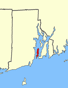
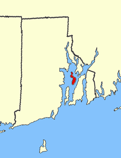
Rabbitt Island is a small island in Wickford Harbor, Narragansett Bay, Wickford, Rhode Island. Roger Williams received the island from Chief Canonicus' wife as a gift for a place to raise his goats. Richard Smith, who built Smith's Castle, later owned the island.
Rose Island is an 18.5-acre (7.5 ha) island in Narragansett Bay off Newport, Rhode Island, United States. It is allegedly named "Rose Island" because at low tide the island appears to be shaped like a rose. The Island is only accessible by boat. The island and its lighthouse are run by the private, non-profit Rose Island Lighthouse Foundation.
Rock Island is an island in Narragansett Bay in the U.S. state of Rhode Island.

Washington County, known locally as South County, is a county located in the U.S. state of Rhode Island. As of the 2020 census, the population was 129,839. Rhode Island counties have no governmental functions other than as court administrative and sheriff corrections boundaries, which are part of the state government.
Sandy Point Island is a 35-acre (14 ha) island in Little Narragansett Bay, lying mostly in Westerly, Rhode Island and partly in Stonington, Connecticut. Once an extension of Napatree Point, Sandy Point is now a one-mile-long (1.6 km) island that serves as an important nature preserve and recreation site. Sandy Point is the westernmost piece of land in the state of Rhode Island.
The Narragansett Runestone, also known as the Quidnessett Rock, is a 2.5 t (2,500 kg) slab of metasandstone located in Rhode Island, United States. It is inscribed with two rows of symbols, which some have indicated resemble ancient runic characters.
Cocumscussoc is a brook and surrounding region in what is now Wickford, Rhode Island. The Cocumscussoc Brook flows into Mill Cove off of Wickford Harbor. In the 1630s-1640s Roger Williams started a trading post with the Narragansetts likely northeast of the brook and harbor which was an ideal location because this was near where the Narragansetts created wampum and traded as currency for other goods. Adjacent to the site of Williams' trading post in Cocumscussoc was Smith's Castle (1678), which was also originally a fortified house and trading post of Richard Smith. Female sachem Quaiapen lived near Cocumscussoc and was associated with nearby Queen's Fort after inheriting her husband's lands in 1657. Today Cocumscussoc State Park preserves much of the land surrounding Cocumscussoc Brook.
