Claiborne Pell Newport Bridge

Last updated
Newport Bridge
Claiborne Pell Newport Bridge.jpg
Pell Bridge from the Jamestown side, 2009
Coordinates 41°30′10.28″N71°20′21.76″W / 41.5028556°N 71.3393778°W / 41.5028556; -71.3393778
CarriesFour lanes of Rhode Island 138.svg Route 138
Crosses Narragansett Bay
LocaleBetween Jamestown and Newport, Rhode Island
Official nameClaiborne Pell Newport Bridge
Maintained byRhode Island Turnpike and Bridge Authority
Characteristics
Design Suspension bridge with deck truss approaches
Total length11,248 ft (3,428 m)
Width48 ft (15 m)
Height400 ft (120 m) [1]
Longest span1,600 ft (490 m)
Clearance below 206 ft (63 m) at mid-span
History
OpenedJune 28, 1969
Statistics
Daily traffic 27,000
TollCars $6.00 per car both ways (without an E-Z Pass transponder) [2]
Location
Claiborne Pell Newport Bridge

The Claiborne Pell Bridge, commonly known as the Newport Bridge, is a suspension bridge operated by the Rhode Island Turnpike and Bridge Authority that spans the East Passage of the Narragansett Bay in Rhode Island (northeastern United States). The bridge, part of RI 138, connects the city of Newport on Aquidneck Island and the Town of Jamestown on Conanicut Island, and is named for longtime Rhode Island U.S. senator Claiborne Pell who lived in Newport. The Pell Bridge is in turn connected to the mainland by the Jamestown Verrazzano Bridge.

Contents

Dimensions

The main span of the Newport Bridge is 488 metres (1,601 ft), making it the longest suspension bridge in New England. The overall length of the bridge is 3,428 meters (11,247 feet). Its main towers reach 122 meters (400 feet) above the water surface, and the roadway height reaches as high as 66 meters (217 feet). [3] It is four lanes wide, two in each direction. On a clear day, the bridge's towers are visible from the observation plaza at the Gay Head Light in Aquinnah on the Massachusetts island of Martha's Vineyard, from the upper floors of skyscrapers in Providence (approximately 22 miles), and as far northwest as the parking lot of Stone Hill Marketplace in Johnston, RI (approximately 23 miles) and Interstate 295 south in Smithfield north of U.S. Route 44. The Providence skyline is likewise visible from the bridge deck.

Tolls

The Claiborne Pell Newport Bridge is a toll bridge. As of 2022, the toll is US$4.00 for cars with a non-resident EZ-Pass, and US$6.00 for cars without an EZ-Pass. The toll for Rhode Island residents with an EZ-Pass is US$0.83. [4]

From its opening in 1969 until 2009, the toll could be paid by cash or with tokens, which were purchased at the RIBTA office in Jamestown. E-ZPass was introduced as a toll payment in 2008. [5] Shortly thereafter, the tokens were phased out as a form of toll payment. The final day that tokens were accepted on the bridge was December 31, 2009. [6] Following that date, the only accepted forms of payment were cash or E-ZPass.

Rhode Island residents with a Rhode Island E-ZPass pay a discounted toll of only 83 cents once they sign up for the RIR-RI Resident Discount Plan. Early in 2012, the Authority had voted to raise tolls for passenger vehicles to $5. However, on June 15, 2012, this plan was abolished as Rhode Island lawmakers approved tolls to be added to the newly built Sakonnet River Bridge in the future. [7] The bridge also charges a fee equal to the toll for improperly mounted E-ZPass transponders that require a toll-booth operator to manually raise the gate. [8] Out-of-state residents pay full price, even with a Rhode Island E-ZPass, making this bridge the only toll facility in the U.S. to give a residence discount that isn't limited to the adjacent neighborhoods. The bridge was the only toll road in Rhode Island until August 19, 2013, when the Authority began collecting tolls on the new Sakonnet River Bridge. [9] However, toll collection on that bridge ended on June 20, 2014. [10]

Cash tolling was discontinued on the bridge in October 2021 in favor of all-electronic tolling through EZ-Pass or bill-by-mail. [11]

Bicycles and pedestrians are not permitted on this bridge, but Rhode Island Public Transit Authority bus #64 has bike racks for weekday and Saturday travel. [12]

History

The bridge was constructed from 1966 to 1969 at a cost of U.S.$54,742,000 by the Parsons, Brinckerhoff, Quade & Douglas company.[ citation needed ]

The bridge opened on June 28, 1969, with ceremonies, celebrations, and fanfare. [13]

The bridge was renamed for U.S. Senator Claiborne Pell in 1992, though it is still commonly referred to as the Newport Bridge by residents of nearby towns. [14] [15]

The bridge was featured on the Rhode Island state quarter in 2001. [16]

The first time that runners were allowed over the bridge was when a group of 300 runners ran over in the early 1980s in a half-marathon for Save The Bay. In the fall of 2011, the inaugural Citizens Bank Newport Pell Bridge Run was held which marked the first time in recent history that runners were allowed to cross the bridge (which was closed to traffic). [17]

Introduction of E-ZPass

In the spring of 2012, the Bridge Authority brought Open Road Tolling to the Pell bridge, allowing drivers with E-ZPass to pass through a special E-ZPass only toll lane at 40 mph. Violators are subject to a $10 fine, on top of the unpaid toll. The new lanes opened to traffic on June 22, in time for the America's Cup sailing race being held in Newport. Before the establishment of the E-ZPass system of toll collection, toll discounts were available to the general population through the use of tokens. A roll of 9 bridge crossing tokens could be purchased for $10 (plus one free crossing) bringing the effective price per crossing $1, available to anyone. The establishment of the E-ZPass system and the elimination of tokens also eliminated discounts for non-residents.

50th anniversary

In June 2019, a series of events were held to mark the 50th anniversary of the bridge. [18] On June 28, a ribbon-cutting ceremony was held on the lawn of nearby Gurney's Newport Resort & Marina. [13] In attendance were Senator Sheldon Whitehouse, Zechariah Chafee, son of the late Governor John Chafee, former Governor Donald Carcieri, Dallas Pell, daughter of late Senator Claiborne Pell, and Rep. David Cicilline. [13] The ceremony included a U.S. Coast Guard flyover salute, a fireboat shooting water into the air, and two ribbon-cuttings. [13] In addition, concerts were scheduled for Fort Adams State Park, along with cruises, fireworks, and other events. [18] A documentary on the construction and history of the bridge, titled The Newport Bridge: A Rhode Island Icon, debuted on Rhode Island PBS on December 4. [19]

Reconstruction of approach and onramps

The approach and access road to and from the bridge in Newport was initially intended to be part of a highway connecting to Rhode Island Route 24 in Portsmouth that was never completed. Instead, traffic from the bridge was unloaded at a stoplight on Admiral Kalbfus Highway facing the Newport Grand slot parlor. [20] [21] The onramp overpass for eastbound traffic coming off the Pell Bridge was locally dubbed the "Bridge to Nowhere" or "Highway to Nowhere". [21] [22] Plans to reconstruct and reconfigure the bridge access roads were made between 2001 and 2020. [20] Ground was broken on the new onramp in July 2021. [21] The new approach, which utilizes a former portion of Halsey Street, was opened in October 2022 for eastbound traffic. [23] [24] Traffic on and off the bridge began using the new connector roads in January 2023. [25] [26] A segment of JT Connell Highway that was bisected during the construction of the Newport Bridge was reconnected in March 2023, and provides a direct connection between the North End neighborhood and downtown Newport that had previously utilized the bridge ramps. [27] The so-called "Bridge/Highway to Nowhere" overpass was demolished in April 2023. [22] [28]

Impact on the region

The building of the bridge changed Conanicut Island's lifestyle and economy significantly. [29] Before the bridge, Jamestown was a "summer-resident town" accessible only by ferry on the east passage side and the Jamestown Bridge from the mainland over the west passage, in which one-third of the residents owned summer homes. [29] After the bridge it has become a more wealthy community whose residents now commute to jobs and opportunities in neighboring towns. [29] At the same time, the island's local commerce became more dependent on tourism by visitors from off-island. [29]

See also

Related Research Articles

<span class="mw-page-title-main">New Jersey Turnpike</span> Toll road in New Jersey

The New Jersey Turnpike (NJTP) is a system of controlled-access toll roads in the U.S. state of New Jersey. The turnpike is maintained by the New Jersey Turnpike Authority (NJTA). The 117.20-mile (188.62 km) mainline's southern terminus is at Interstate 295 (I-295) and U.S. Route 40 (US 40) in Pennsville Township in Salem County, near the Delaware Memorial Bridge. Its northern terminus is at the approach to the George Washington Bridge in Fort Lee in Bergen County; originally it was at an interchange with I-80 and US 46 in Ridgefield Park. Construction of the mainline from concept to completion took 22 months, from 1950 to 1951. It was opened to traffic on November 5, 1951, between its southern terminus and exit 10.

<span class="mw-page-title-main">Jamestown, Rhode Island</span> Town in Rhode Island, United States

Jamestown is a town in Newport County, Rhode Island in the United States. The population was 5,559 at the 2020 census. Jamestown is situated almost entirely on Conanicut Island, the second largest island in Narragansett Bay. It also includes the uninhabited Dutch Island and Gould Island.

<span class="mw-page-title-main">Garden State Parkway</span> Toll road in New Jersey

The Garden State Parkway (GSP) is a controlled-access toll road that stretches the north–south length of eastern New Jersey from the state's southernmost tip near Cape May north to the New York state line at Montvale. Its name refers to New Jersey's nickname, the "Garden State". The parkway is designated by the New Jersey Department of Transportation (NJDOT) as Route 444, although this designation is unsigned. At its north end, the road becomes the Garden State Parkway Connector, a component of the New York State Thruway system that connects to the Thruway mainline in Ramapo.

E-ZPass is an electronic toll collection system used on toll roads, toll bridges, and toll tunnels in the Eastern United States, Midwestern United States, and Southern United States. The E-ZPass Interagency Group (IAG) consists of member agencies in several states, which use the same technology and allow travelers to use the same transponder on toll roads throughout the network.

<span class="mw-page-title-main">Aquidneck Island</span> Island in Rhode Island, United States

Aquidneck Island, officially known as Rhode Island, is an island in Narragansett Bay in the state of Rhode Island. The total land area is 37.8 sq mi (98 km2), which makes it the largest island in the bay. The 2020 United States Census reported its population as 60,109. The state of Rhode Island is named after the island; the United States Board on Geographic Names recognizes Rhode Island as the name for the island, although it is widely referred to as Aquidneck Island in the state and by the island's residents.

<span class="mw-page-title-main">Conanicut Island</span> Island in Rhode Island, US

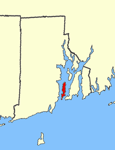
Conanicut Island is an island in Narragansett Bay in the American state of Rhode Island. The second-largest in the Bay, it is connected on the east to Newport on Aquidneck Island by the Claiborne Pell Bridge, commonly known as the Newport Bridge, and on the west to North Kingstown on the mainland via the Jamestown-Verrazano Bridge. The town of Jamestown comprises the entire island. The U.S. Census Bureau reported a land area of 24.46 km2 (9.44 sq mi) and a population of 5,622 in 2000. A tombolo connects the southern part of Conanicut to an extension of the island to the southwest.

<span class="mw-page-title-main">Delaware Memorial Bridge</span> Twin suspension bridge between New Castle, Delaware and Pennsville Township, New Jersey

The Delaware Memorial Bridge is a dual-span suspension bridge crossing the Delaware River. The toll bridges carry Interstate 295 and U.S. Route 40 and is also the link between Delaware and New Jersey. The bridge was designed by the firm of Howard, Needles, Tammen & Bergendoff with consulting help from engineer Othmar Ammann, whose other designs include the George Washington Bridge and the Verrazzano-Narrows Bridge.

<span class="mw-page-title-main">Interstate 195 (Rhode Island–Massachusetts)</span> Highway in Rhode Island and Massachusetts

Interstate 195 (I-195) is an auxiliary Interstate Highway running a combined 44.55 miles (71.70 km) in the US states of Rhode Island and Massachusetts. It travels from a junction with I-95 in Providence, Rhode Island, east to a junction with I-495 and Massachusetts Route 25 in Wareham, Massachusetts. It runs east–west and passes through the cities of Fall River, Massachusetts, and New Bedford, Massachusetts. The portion of I-195 in East Providence is also known as the East Providence Expressway.

<span class="mw-page-title-main">Rhode Island Route 24</span> State highway in Newport County, Rhode Island, US

Route 24 is a freeway in the U.S. state of Rhode Island. It runs approximately 8 miles (13 km) from Route 114 in Portsmouth to Massachusetts Route 24 in Fall River, Massachusetts. Route 24 is the primary freeway access for the two towns in the southeastern corner of the state, Tiverton and Little Compton. Though on the mainland, they are isolated from the rest of the state by an arm of the Narragansett Bay. Because of this, the main freeway connection to Providence involves using Rhode Island Route 24, Massachusetts Route 24, and Interstate 195.

<span class="mw-page-title-main">Rhode Island Route 37</span> State highway in Rhode Island, US

Route 37 is a state highway running 3.47 miles (5.58 km) in Providence County and Kent County, Rhode Island, United States. A freeway for its entire length, it serves the cities of Cranston and Warwick and is also a major east–west freeway in the Providence metropolitan area, linking T. F. Green Airport with Interstate 295. The western terminus of Route 37 is an at-grade intersection with Natick Avenue in Cranston. The freeway has numbered interchanges with I-295, Rhode Island Route 2, Pontiac Avenue, and I-95 before terminating at a trumpet interchange with U.S. Route 1 in Warwick.

<span class="mw-page-title-main">Mount Hope Bridge</span> Bridge in Mount Hope Bay, Rhode Island

The Mount Hope Bridge is a two-lane suspension bridge spanning the Mount Hope Bay in eastern Rhode Island at one of the narrowest gaps in Narragansett Bay. The bridge connects the Rhode Island towns of Portsmouth and Bristol and is part of Route 114. Its towers are 285 feet (87 m) tall, the length of the main span is 1,200 feet (370 m), and it offers 135 feet (41 m) of clearance over high water. The total length of the bridge is 6,130 feet (1,870 m).

<span class="mw-page-title-main">Rhode Island Route 138</span> Highway in Rhode Island

Route 138 is a numbered State Highway running 48.3 miles (77.7 km) in Rhode Island. It is the longest state numbered route in Rhode Island, and the second longest highway after US 1. Route 138 begins in Exeter at the Connecticut state line in the west and runs to the Massachusetts state line in Tiverton in the east, and is the only state-numbered route to completely cross Rhode Island. Route 138 also keeps the same route number on the other side of both state lines.

<span class="mw-page-title-main">Jamestown Bridge</span> Now-demolished bridge in Rhode Island

The Jamestown Bridge was a cantilever truss bridge that connected Conanicut Island to mainland North Kingstown, Rhode Island, spanning the West passage of Narragansett Bay. The bridge first opened to traffic in 1940, replacing ferry service as the primary connection for the town of Jamestown, situated on Conanicut Island. It was constructed for just over $3 million 1940 USD, which was paid for by tolls until June 28, 1969. With a total length of 6,892 feet, the Jamestown Bridge was the third longest in Rhode Island at the time of its destruction, ranking behind its replacement, the adjacent 7,350-foot Jamestown Verrazzano Bridge, and the 11,248-foot Claiborne Pell Newport Bridge connecting Conanicut Island to Aquidneck Island and Newport. The Jamestown Bridge was closed to vehicular traffic on October 8, 1992, and its main span was destroyed through a controlled demolition on April 18, 2006.

<span class="mw-page-title-main">Sakonnet River Bridge</span> Bridge in between Portsmouth and Tiverton

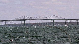
Sakonnet River Bridge is a four-lane bridge spanning the Sakonnet River in eastern Rhode Island. The bridge carries RI 24 and RI 138 between the communities of Portsmouth and Tiverton, Rhode Island. The current bridge is a box girder bridge that opened in 2012 at a cost of $120 million (USD). The previous bridge was a truss bridge that was built in 1956 and demolished in 2012 due to structural deficiencies. The truss bridge had previously served as a replacement for the Stone Bridge, about 0.8 miles (1.3 km) to the south.

<span class="mw-page-title-main">Open road tolling</span> Boothless toll collecting

Open road tolling (ORT), also called all-electronic tolling, cashless tolling, or free-flow tolling, is the collection of tolls on toll roads without the use of toll booths. An electronic toll collection system is usually used instead. The major advantage to ORT is that users are able to drive through the toll plaza at highway speeds without having to slow down to pay the toll. In some installations, ORT may also reduce congestion at the plazas by allowing more vehicles per hour/per lane.

<span class="mw-page-title-main">Interstate 95 in Rhode Island</span> Section of Interstate 95

Interstate 95 (I-95) is the main north–south Interstate Highway on the East Coast of the United States, running generally southwest–northeast through the US state of Rhode Island. It runs from the border with Connecticut near Westerly, through Warwick and Providence, and to the Massachusetts state line in Pawtucket. It has two auxiliary routes, both of which enter Massachusetts—I-195, a spur from Providence east to Cape Cod, and I-295, a western bypass of the Providence metropolitan area.

<span class="mw-page-title-main">U.S. Route 1 in Rhode Island</span> Section of U.S. Route in Rhode Island, United States

U.S. Route 1 (US 1) is a major north–south U.S. Route through the U.S. state of Rhode Island, specifically within the Providence metropolitan area. Staying close to the Atlantic Ocean and Narragansett Bay, it is a longer route than Interstate 95 (I-95), and many portions are a four-lane divided highway.

<span class="mw-page-title-main">Rhode Island Department of Transportation</span>

The Rhode Island Department of Transportation (RIDOT) is a Rhode Island state government agency charged with design, construction, maintenance and inspection of a wide range of transportation infrastructure. These include 3,300 lane miles of state roads and highways, 1,162 bridges, 777 traffic signals, and six rail stations. Additionally, RIDOT has constructed a 50-mile (80 km) network of off-road bike paths and signed more than 90 miles (140 km) of on-road bike routes across the state. Its headquarters are located in Providence.

<span class="mw-page-title-main">Interstate 895 (Rhode Island–Massachusetts)</span> Former proposed Interstate Highway in Rhode Island and Massachusetts

Interstate 895 was a proposed Interstate Highway in Rhode Island and Massachusetts that would have supplemented Interstate 295 to create a full beltway around Providence.

References

  1. "Claiborne Pell (Newport) Bridge (RI 138)" . Retrieved 2008-04-28.
  2. "Tolls on Newport Pell Bridge increase for those without E-ZPass". WJAR. 1 December 2021. Retrieved 10 December 2021.
  3. "Pell Bridge paint job: $78 million", Projo.com, 2007-08-31, retrieved 2007-08-31
  4. "Tolls | Rhode Island Turnpike and Bridge Authority". www.ritba.org. Retrieved 2 July 2022.
  5. Naylor, Donita. "Newport Pell Bridge will close 'high-speed' toll lanes for 17 days to install upgrades". providencejournal.com. Retrieved 11 October 2016.
  6. "Redeem bridge tokens before Dec. 31 | www.jamestownpress.com | Jamestown Press". Jamestown Press. Archived from the original on 11 October 2016. Retrieved 11 October 2016.
  7. "No increase for Pell Bridge tolls". Archived from the original on 2012-06-19. Retrieved 2012-06-19.
  8. "Unmounted E-ZPass will cause extra fees". Archived from the original on 2012-11-07. Retrieved 2012-05-01.
  9. "Rhode Island Turnpike and Bridge Authority Tolls" . Retrieved 2013-11-11.
  10. "Tolling on Sakonnet River Bridge Ends on Friday" (PDF). Rhode Island Turnpike and Bridge Authority. Retrieved 2014-06-20.
  11. Read, Sam (27 October 2021). "Newport Pell Bridge converts to all-electronic tolling". WJAR. Retrieved 10 December 2021.
  12. Bike Rhode Island and Guide to Bicycling in the Ocean State 2005-2006, Rhode Island Department of Transportation
  13. 1 2 3 4 Gomes, Derek (28 June 2019). "Pell Bridge 50th anniversary a celebration of what the span means to all". The Providence Journal. Retrieved 29 June 2019.
  14. "Span clearly has left mark on the region". Jamestown Press. 28 June 2019. p. 2. Retrieved 29 June 2019.
  15. Gentile, Isabella. "For locals, it's still the 'Newport Bridge'". providencejournal.com. Retrieved 17 July 2019.
  16. "Rhode Island State Quarter". United States Mint. US Mint. Retrieved 29 June 2019.
  17. "Citizens Pell Bridge Run". Citizens Pell Bridge Run. Retrieved 8 October 2021.
  18. 1 2 Riel, Tim (27 June 2019). "Anniversary celebration filed with fun, food, fireworks". Jamestown Press. Retrieved 29 June 2019.
  19. "PBS to broadcast film on Newport Pell Bridge". providencejournal.com. Retrieved 27 June 2020.
  20. 1 2 "Reconstruction of the Newport Pell Bridge Approaches - Rhode Island Department of Transportation". www.dot.ri.gov. Retrieved 7 October 2022.
  21. 1 2 3 Belmore, Ryan (16 July 2021). "Ground broken for Newport Pell Bridge Ramps Phase 2 Project". What's Up Newp. Retrieved 7 October 2022.
  22. 1 2 "'Bridge to Nowhere' to be Demolished in 2023 - Newport This Week". Newport This Week -. 18 August 2022. Retrieved 7 October 2022.
  23. "A change is coming to the Newport Pell Bridge off ramp. Here's what you need to know". Newport Daily News. Retrieved 7 October 2022.
  24. "Come along for the ride: Daily News tests out new ramp off Newport Pell Bridge". Newport Daily News. Retrieved 7 October 2022.
  25. "After delays, RIDOT plans changes to Pell Bridge ramp traffic flow. What you need to know". Newport Daily News. Retrieved 17 February 2023.
  26. "RIDOT Making Improvements to Ease Congestion at Pell Bridge Ramps - Newport This Week". Newport This Week. 3 January 2023. Retrieved 17 February 2023.
  27. "RIDOT announces reconnection of JT Connell Highway sections". Newport Daily News. Retrieved 22 April 2023.
  28. "RIDOT announces road closure to remove Route 138 overpass". Newport Daily News. Retrieved 22 April 2023.
  29. 1 2 3 4 "Pell Bridge greatly changed island life". Jamestown Press. 27 June 2019. Retrieved 29 June 2019.