Newport Historic District (Rhode Island)

Last updated

Newport Historic District
Spring and Mary streets, Newport, RI edit.jpg
Colonial architecture at Spring and Church Streets, 2008
USA Rhode Island location map.svg
Red pog.svg
Usa edcp location map.svg
Red pog.svg
Location Newport, RI
Coordinates 41°29′24″N71°18′49″W / 41.49000°N 71.31361°W / 41.49000; -71.31361
Area250 acres (100 ha)
Builtlate 17th-late 19th century
Architectural style Georgian, Colonial, mix of later styles
NRHP reference No. 68000001
Significant dates
Added to NRHPNovember 24, 1968 [1]
Designated NHLDNovember 24, 1968 [2]

The Newport Historic District is a historic district that covers 250 acres (100 ha) in the center of Newport in the U.S. state of Rhode Island. It was designated a National Historic Landmark (NHL) in 1968 due to its extensive and well-preserved assortment of intact colonial buildings dating from the early and mid-18th century. Six of those buildings are themselves NHLs in their own right, including the city's oldest house and the former meeting place of the colonial and state legislatures. Newer and modern buildings coexist with the historic structures.

Contents

It is a major tourist attraction due to its history, its setting on Newport's waterfront and the shops located within it along Thames Street. In 1997, it doubled for mid-19th-century New Haven, Connecticut during the production of Steven Spielberg's Amistad . [3] "No comparable collection of colonial buildings exists today in the state or perhaps the nation", says Rhode Island historian William McLoughlin. [4]

Geography

The district is described by the National Register of Historic Places (NRHP) as being roughly bounded by Van Zandt Avenue to the north; Farewell, Sherman, High and Thomas streets on the east; Golden Hill, Thames and Marsh streets in the south and Washington Street on the west, just before the shores of Narragansett Bay. This area includes the Easton's Point neighborhood and its concentration of colonial houses on the north, Washington Square, the shops and stores along Thames Street near the waterfront, and the blocks inland up the gentle rise to the Bellevue Avenue neighborhoods.

Shops along Thames Street Thames and Mary streets, Newport, RI.jpg
Shops along Thames Street

Land use varies from commercial, mainly street-level retailing, along heavily trafficked Thames and America's Cup Avenue to primarily residential along the side streets to the east. The narrowness of these streets, built long before the automobile, has led the city to restrict parking along them to residents with a valid permit.

In 2007 the city proposed increasing the district's boundaries to include the ten-acre (4 ha) common burial ground at the north end, which dates to 1660. [5] As of 2008 the National Park Service has not announced whether it will approve the request.

History

Colonial era

The historic district is the core of the original city of Newport as it was during the years from its founding in 1639 to the American Revolution, when it served as the colonial capital. Surviving buildings date from the last years of the 17th century. The White Horse Tavern has stood on the same site since 1652, with the current building dating to 1673. The Wanton-Lyman-Hazard House, built by at least 1697, is the city's oldest house museum. [4] Most of those early homes were simple clapboard structures in vernacular English styles that the colonists had adapted to the locally available materials.

Wood was also used to build Trinity Church, whose tall white spire is one of the city's most distinctive landmarks. In the early 1730s, efforts to bring some formal planning to Newport's development resulted in the construction of two major brick buildings showing heavy influence of the Georgian style then being popularized in London by Sir Christopher Wren. The Old Colony House and the Brick Market stand at opposite ends of Washington Square, then known as the Parade, and were meant to make it the kind of dignified public space found in English cities of the period.

Religious tolerance led to the immigration of Quakers from Massachusetts, where they were regarded as heretics, and communities of Sephardi Jews from Portugal. These left their mark with the Great Friends Meeting House on Marlborough Street, the oldest house of worship in Rhode Island, built in 1699, and Touro Synagogue, the oldest in the Western Hemisphere. [6] The Quakers settled heavily in Easton's Point, building many of the wooden houses there and naming many of its streets after trees.

The city prospered as it became a more important port, and eventually sea captains who had made their fortunes began to settle down and build larger houses for themselves. [6] One of these homes, Hunter House, another NHL located along the water in Easton's Point, is preserved today for its quality cabinetry, much of it originally manufactured in Newport. [7]

19th century

After independence the city lost some cachet when Providence, the wartime state capital, became the main capital. Still, the legislature continued to meet at the Colony House every other session, and held a ceremonial meeting there every April on 'Lection Day, when the results of the state's March elections were announced and the winners sworn in. It drew crowds from all over the state, and was Newport's major holiday for much of the 19th century. [8]

Throughout most of that century, the downtown area remained a major, although somewhat neglected, port area, sustained by the nearby naval presence. Fleets were based in Newport, and the Naval War College is nearby, along with other naval facilities along the western shore of Aquidneck Island. Newer buildings in 19th-century styles, particularly Italianate, were erected along Thames, and many of these were home to businesses that catered to sailors on leave.

20th century

In the years after the Civil War, the new rich of the Gilded Age began to rediscover Newport as a summer getaway, building larger and larger homes along and near Bellevue Avenue to the east. After the legislature moved to Providence full-time in 1900, depriving the city of some of its economy, the newer residents began to show an interest in preserving Newport's rich architectural past. They established the Newport Historical Society, and endowed some of their family fortunes towards architect Norman Isham's projects to restore the Wanton-Lyman-Hazard House, the Brick Market and Colony House during the 1920s and '30s. [6] The fight to save the Hunter House from demolition led to the formation of another important local organization, the Preservation Society of Newport County.

Other local efforts concentrated on other houses later on, and they were eventually recognized with the NHL designations of the individual buildings in the early 1960s. The city created the district by ordinance in 1965, [9] and it was recognized as an NHL itself in 1968. [2] [10]

The loss of the naval fleet in 1971 was a serious blow to the economy, and eventually the city controversially authorized the removal of many old factories, warehouses, and historic structures along the water, just west of the district boundary for the construction of retail facilities such as Brick Market Place and Long Wharf Mall, hotels, condominiums and America's Cup Avenue, a multilane through street whose name reflected the sloop races that then drew crowds to the city every few years.

In the mid-1980s, the America's Cup was finally lost to an Australian team, and left the city. The downtown area adapted by focusing on shopping opportunities for the tourists who were drawn to Newport to visit the many mansions every summer, and promoting its own historic buildings. The historic district retained enough of its character that Steven Spielberg came there in 1997 to film Amistad , deeming it a sufficient stand-in for 1840s New Haven, Connecticut, where the real case took place. The interiors of several historic buildings, especially Colony House, were used as sets for scenes in the film. [3]

Significant contributing properties

Many of the 392 buildings within the district are considered contributing properties to its historic character. These include five National Historic Landmarks and other buildings listed on the NRHP in their own right.

National Historic Landmarks

Unless otherwise noted, these are managed as museums by the Newport Historical Society.

Registered Historic Places

The White Horse Tavern The White Horse Tavern Newport Rhode Island est. 1673.jpg
The White Horse Tavern

Historic District Commission

To maintain the district's historic character, the city created its Historic District Commission (HDC) at the same time as the district itself. It consists of nine citizens appointed to three-year terms by the City Council to oversee not just the downtown historic district but Newport's other historic districts, two of which (Bellevue Avenue and Ocean Drive) are also recognized as National Historic Landmarks. The city considers them all one large district for its administrative purposes. [9]

The HDC must review any exterior alterations to a building in the district beyond ordinary maintenance and repair, and issue a Certificate of Appropriateness. It cannot order any changes made to a property. [9]

See also

Related Research Articles

<span class="mw-page-title-main">Newport, Rhode Island</span> City in Rhode Island, United States

Newport is a seaside city on Aquidneck Island in Rhode Island, United States. It is located in Narragansett Bay, approximately 33 miles (53 km) southeast of Providence, 20 miles (32 km) south of Fall River, Massachusetts, 74 miles (119 km) south of Boston, and 180 miles (290 km) northeast of New York City. It is known as a New England summer resort and is famous for its historic mansions and its rich sailing history. The city has a population of about 25,000 residents.

<span class="mw-page-title-main">Touro Synagogue</span> Historic synagogue in Rhode Island, United States

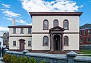
The Touro Synagogue or Congregation Jeshuat Israel is a synagogue built in 1763 in Newport, Rhode Island. It is the oldest synagogue building still standing in the United States, the only surviving synagogue building in the U.S. dating to the colonial era, and the oldest surviving Jewish synagogue building in North America. In 1946, it was declared a National Historic Site.

<span class="mw-page-title-main">Hunter House (Newport, Rhode Island)</span> Historic house in Rhode Island, United States

Hunter House (1748) is a historic house in Newport, Rhode Island. It is located at 54 Washington Street in the Easton's Point neighborhood, near the northern end of the Newport Historic District.

<span class="mw-page-title-main">Redwood Library and Athenaeum</span> Subscription library in Newport, Rhode Island, United States

The Redwood Library and Athenaeum is a subscription library, museum, rare book repository and research center founded in 1747, and located at 50 Bellevue Avenue in Newport, Rhode Island. The building, designed by Peter Harrison and completed in March 1750, was the first purposely built library in the United States, and the oldest neo-Classical building in the country. It has been in continuous use since its opening.

The Newport Historical Society is a historical society in Newport, Rhode Island that was chartered in 1854 to collect and preserve books, manuscripts, and objects pertaining to Newport's history.

<span class="mw-page-title-main">Kingscote (mansion)</span> Historic house in Rhode Island, United States

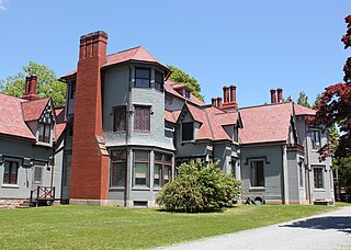
Kingscote is a Gothic Revival mansion and house museum at Bowery Street and Bellevue Avenue in Newport, Rhode Island, designed by Richard Upjohn and built in 1839. As one of the first summer "cottages" constructed in Newport, it is now a National Historic Landmark. It was remodeled and extended by George Champlin Mason and later by Stanford White. It was owned by the King family from 1864 until 1972, when it was given to the Preservation Society of Newport County.

<span class="mw-page-title-main">Museum of Newport History</span> United States historic place

The Museum of Newport History is a history museum in the Old Brick Market building in the heart of Newport, Rhode Island, United States. It is owned and operated by the Newport Historical Society at 127 Thames Street on Washington Square. The building, designed by noted 18th-century American architect Peter Harrison and built in the 1760s, is a National Historic Landmark.

<span class="mw-page-title-main">Bellevue Avenue Historic District</span> United States historic place in Newport, Rhode Island

The Bellevue Avenue Historic District is located along and around Bellevue Avenue in Newport, Rhode Island, United States. Its property is almost exclusively residential, including many of the Gilded Age mansions built as summer retreats around the turn of the 20th century by the extremely wealthy, including the Vanderbilt and Astor families. Many of the homes represent pioneering work in the architectural styles of the time by major American architects.

<span class="mw-page-title-main">Wanton–Lyman–Hazard House</span> Historic house in Rhode Island

The Wanton–Lyman–Hazard House is the oldest house in Newport, Rhode Island, built around 1697. It is also one of the oldest houses in the state. It is located at the corner of Broadway and Stone Street, in the downtown section of the city in the Newport Historic District. The house "was damaged by Stamp Act riots in 1765 when occupied by a Tory Stampmaster."

<span class="mw-page-title-main">Old Colony House</span> Historic house in Rhode Island, United States

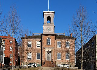
The Old Colony House, also known as Old State House or Newport Colony House, is located at the east end of Washington Square in the city of Newport, Rhode Island, United States. It is a brick Georgian-style building completed in 1741, and was the meeting place for the colonial legislature. From independence in 1776 to the early 20th century, the state legislature alternated its sessions between here and the Rhode Island State House in Providence.

<span class="mw-page-title-main">Easton's Point</span>

The Point is one of the oldest neighborhoods in Newport, Rhode Island and has one of the highest concentrations of colonial houses in the United States. The neighborhood sits between Washington Street and Farewell Street/America's Cup in Newport looking out on Goat Island, former home to the U.S. Naval Torpedo Station.

<span class="mw-page-title-main">Old State House (Providence, Rhode Island)</span> United States historic place

The Old State House on College Hill in Providence, Rhode Island, also known as Providence Sixth District Court House,Providence Colony House, Providence County House, and Rhode Island State House is located on 150 Benefit Street, with the front facade facing North Main Street. It is a brick Georgian-style building largely completed in 1762. It was used as the meeting place for the colonial and state legislatures for 149 years.

<span class="mw-page-title-main">Ocean Drive Historic District</span> Historic district in Rhode Island, United States

The Ocean Drive Historic District is a historic district that covers the long street of the same name along the southern shore of Newport, Rhode Island, United States. It was designated a National Historic Landmark District in 1976, in recognition for its distinctive landscape and architecture, which is less formal and generally not as ostentatious as the grand summer properties of Bellevue Avenue.

<span class="mw-page-title-main">Kay Street–Catherine Street–Old Beach Road Historic District</span> Historic district in Rhode Island, United States

The Kay Street–Catherine Street–Old Beach Road Historic District is a historic district in Newport, Rhode Island. The area is located north of Newport's well-known Bellevue Avenue, and encompasses an area that was developed residentially between about 1830 and 1890, for the most part before the Gilded Age mansions were built further south. The district is bounded on the south by Memorial Boulevard, on the east by Easton's Pond, on the west by Bellevue Avenue and Kay and Bull Streets, and on the north by Broadway, Rhode Island Avenue, Prairie Avenue, and Champlin Street. The district was added to the National Register of Historic Places on May 22, 1973, with a boundary decrease in 2018.

<span class="mw-page-title-main">Francis Malbone House</span> Historic house in Newport, Rhode Island, US

The Francis Malbone House is a historic house at 392 Thames Street in Newport, Rhode Island.

<span class="mw-page-title-main">Southern Thames Historic District</span> Historic district in Rhode Island, United States

The Southern Thames Historic District encompasses the commercial and residential area immediately to the south of the colonial center of Newport, Rhode Island. This area, covering about 135 acres (55 ha), was developed both residentially and commercially between about 1850 and 1920, with the majority of its growth coming in the late 19th century. It is characterized by densely built streets, including Thames Street, Newport's major north–south thoroughfare. The district includes the southern portion of Newport's waterfront, extending south from Memorial Boulevard along Thames and Spring Streets to Morton Street, and west to Marchant Street in its southernmost section. The district's housing stock and commercial architecture are largely vernacular wood-frame structures, set close to the sidewalk on small lots. The waterfront area is composed of wharves with warehouses and other structures, many of which have been converted to commercial use. One of the most prominent buildings in the district is the Emmanuel Episcopal Church, designed by Ralph Adams Cram and built in 1912–13.

<span class="mw-page-title-main">Bellevue Avenue/Casino Historic District</span> Historic district in Rhode Island, United States

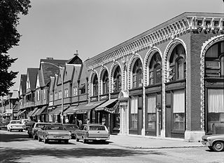
The Bellevue Avenue/Casino Historic District encompasses a one-block section of Bellevue Avenue in Newport, Rhode Island. Although Bellevue Avenue is best known for the large number of Gilded Age mansions which line it, especially further south, this block is a coherent collection of commercial buildings at the northern end of the mansion row. It is anchored around the Newport Casino, now the International Tennis Hall of Fame, and includes three other buildings on the east side of Bellevue Avenue between Memorial Boulevard and East Bowery Street.

<span class="mw-page-title-main">Washington Square (Newport, Rhode Island)</span>

Washington Square is the geographical and historical heart of Newport Rhode Island. More trapezoid than square, it exists at the intersection of several major streets and what was the colonial long wharf, projecting into the harbor off Aquidneck Island and into Narragansett Bay. Although as a civic space it is colonial in origin, dating back to the first settlement of 1639, much of its present shape, form and name dates from the 19th century while a number of its most prominent buildings are of early 20th century design. Like many civic spaces, it developed over time rather than being imposed by design.

<span class="mw-page-title-main">Thames Street, Rhode Island</span>

Thames Street is a historic street in Newport, Rhode Island that is one of the oldest continuously used streets in the state. It remains the primary street in downtown Newport and runs parallel along the waterfront.

Timeline of Newport, Rhode Island.

References

  1. "National Register Information System". National Register of Historic Places. National Park Service. January 23, 2007. Archived from the original on June 1, 2007.
  2. 1 2 "Newport Historic District". National Historic Landmark summary listing. National Park Service. Archived from the original on June 6, 2011. Retrieved April 30, 2008.
  3. 1 2 Sabar, Arial (December 10, 1997). "'Amistad' debuts in R.I." Providence Journal . Archived from the original on October 11, 2008. Retrieved April 25, 2008.
  4. 1 2 McLoughlin, William G. (1986). Rhode Island, A History. New York: W.W. Norton. pp. xiii. ISBN   0-393-30271-7.
  5. "National Historic Landmark nomination, Newport Historic District (Boundary Increase)" (PDF).
  6. 1 2 3 McLoughlin, op. cit., xiii.
  7. Carpenter, Ralph (April 1995). "Newport, a center of colonial cabinetmaking". Magazine Antiques. Archived from the original on March 2, 2006. Retrieved April 25, 2008.
  8. "NHS/The Newport Colony House". Archived from the original on February 6, 2008. Retrieved April 24, 2008.
  9. 1 2 3 "City of Newport – Department of Planning, Zoning and Inspection – Historic District Commission". Archived from the original on May 6, 2008. Retrieved April 27, 2008.
  10. Heintzelman, Patricia & Charles Snell (October 1975). National Register of Historic Places Inventory-Nomination: Newport Historic District / Newport (pdf). National Park Service. and Accompanying 13 photos, from 1975  (32 KB)
  11. Bell, Michael (December 10, 2001). "The Old Navy Y, Newport" . Retrieved April 27, 2008.