The New Jersey Turnpike (NJTP) is a system of controlled-access toll roads in the U.S. state of New Jersey. The turnpike is maintained by the New Jersey Turnpike Authority (NJTA). The 117.20-mile (188.62 km) mainline's southern terminus is at Interstate 295 (I-295) and U.S. Route 40 (US 40) in Pennsville Township in Salem County, near the Delaware Memorial Bridge. Its northern terminus is at the approach to the George Washington Bridge in Fort Lee in Bergen County; originally it was at an interchange with I-80 and US 46 in Ridgefield Park. Construction of the mainline from concept to completion took 22 months, from 1950 to 1951. It was opened to traffic on November 5, 1951, between its southern terminus and exit 10.

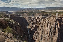
The Royal Gorge Bridge is a tourist attraction near Cañon City, Colorado within Royal Gorge Bridge and Park, a 360-acre (150 ha) amusement park located along the edge of the Royal Gorge around both ends of the bridge. The bridge crosses the gorge 955 feet (291 m) above the Arkansas River and held the record of highest bridge in the world from 1929 until 2001 when it was surpassed by the Liuguanghe Bridge in China. The Royal Gorge Bridge maintained the title of the world's highest suspension bridge until the Beipan River Guanxing Highway Bridge was completed in 2003, also in China. The bridge remains the highest bridge in the United States and was among the ten highest bridges in the world until 2012.

The Cumbres and Toltec Scenic Railroad, often abbreviated as the C&TSRR, is a 3 ft narrow-gauge heritage railroad that operates on 64 miles (103 km) of track between Antonito, Colorado, and Chama, New Mexico, in the United States. The railroad is named for two geographical features along the route: the 10,015-foot (3,053 m)-high Cumbres Pass and the Toltec Gorge. Originally part of the Denver and Rio Grande Western Railroad's narrow-gauge network, the line has been jointly owned by the states of Colorado and New Mexico since 1970. Today, the C&TSRR is one of only two remaining parts of the former D&RGW narrow-gauge network, the other being the Durango and Silverton Narrow Gauge Railroad (D&SNG), which runs between the communities of Durango and Silverton, Colorado. The railroad has a total of ten narrow-gauge steam locomotives and two narrow-gauge diesel locomotives on its current roster. The railroad also operates two smaller former D&RGW steam locomotives, Nos. 315 and 168, for special events and excursions.

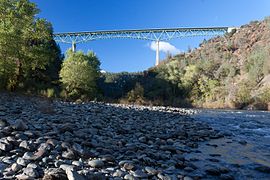
The Foresthill Bridge, also referred to as the Auburn-Foresthill Bridge or the Auburn Bridge, is a road bridge crossing over the North Fork American River in Placer County and the Sierra Nevada foothills, in eastern California. It is the highest bridge by deck height in California, the fourth highest in the United States, and among the seventy highest in the world at 730 feet (220 m) above the river.
The Laurel Creek Gorge Bridge is a continuous steel plate girder bridge that spans Laurel Creek on Interstate 26/U.S. Route 19/U.S. Route 23 between Asheville, North Carolina and Johnson City, Tennessee. It is the second tallest bridge in North Carolina—after the Peter Guice Memorial Bridge—with a deck height of 220 ft (67 m). Construction of the bridge was finished in 2002. Due to its proximity to the higher mountains and its elevation of over 3000', the highway in this area is subject to heavy snow and icing. The bridge design incorporates a special system which sprays de-icing liquid onto the bridge deck whenever icing is detected.
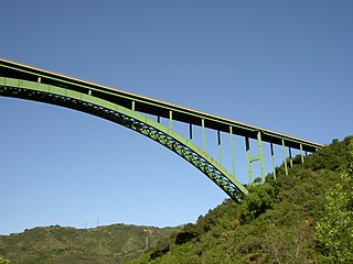
The Cold Spring Canyon Arch Bridge in the Santa Ynez Mountains links Santa Barbara, California with Santa Ynez, California. The bridge is signed as part of State Route 154.

The Cogan House Covered Bridge is a Burr arch truss covered bridge over Larrys Creek in Cogan House Township, Lycoming County, in the U.S. state of Pennsylvania. It was built in 1877 and is 94 feet 2 inches (28.7 m) long. The bridge was placed on the National Register of Historic Places in 1980, and had a major restoration in 1998. The Cogan House bridge is named for the township and village of Cogan House, and is also known by at least four other names: Buckhorn, Larrys Creek, Day's, and Plankenhorn.

The Moyie River Canyon Bridge is a structural steel truss cantilever bridge that spans the Moyie River in the city of Moyie Springs just east of Bonners Ferry, Idaho. Constructed in 1965, the bridge is on U.S. Route 2 at mile marker 70. The bridge is 1,223 ft (373 m) long and 464 ft (141 m) high, and is a replacement for an obsolete 1923 bridge built downstream from Moyie Dam.

The Forksville Covered Bridge is a Burr arch truss covered bridge over Loyalsock Creek in the borough of Forksville, Sullivan County, in the U.S. state of Pennsylvania. It was built in 1850 and is 152 feet 11 inches (46.61 m) in length. The bridge was placed on the National Register of Historic Places in 1980. The Forksville bridge is named for the borough it is in, which in turn is named for its location at the confluence or "forks" of the Little Loyalsock and Loyalsock Creeks.

Thomas Creek Bridge crosses Thomas Creek in Curry County, in the U.S. state of Oregon. It is on U.S. Route 101 and lies within the boundaries of Samuel H. Boardman State Scenic Corridor.

The Aizhai Bridge is a suspension bridge on the G65 Baotou–Maoming Expressway near Jishou, Hunan, China. The bridge was built as part of an expressway from southwest China's Chongqing Municipality to Changsha.
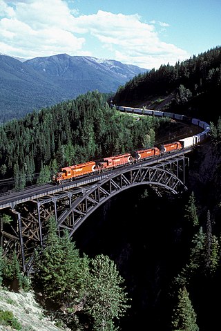
Stoney Creek Bridge is a Canadian Pacific Railway (CP) truss arch in southeastern British Columbia. This single-track crossing over Stoney Creek is in Glacier National Park, between Revelstoke and Golden.

Puli Bridge is a suspension bridge near Xuanwei, Qujing, China. The bridge, at 485 m (1,591 ft), is one of the highest in the world. The bridge forms part of the G56 Hangzhou–Ruili Expressway between Liupanshui and Xuanwei and was opened in August 2015. The bridge and associated expressway reduced the travelling time from Xuanwei to the Guizhou border from four hours to one hour. The bridge crosses a small stream beside the Gexiang River gorge.
The Beaver River Bridge is a bridge that carries the Pennsylvania Turnpike across the Beaver River in North Sewickley Township, Pennsylvania. Built in 1951 and opened in 1952, the 72-year-old bridge is being replaced with the construction of a new span to its north. The Beaver River Bridge has a total length of 1,546 ft (471 m) and a clearance below of 170 ft (52 m) making it higher than the Delaware River Bridge's 160 ft (49 m) clearance on the PA Turnpike's eastern terminus in Bucks County, but lower than the Hawk Falls Bridge's 190 ft (58 m) clearance on the Pennsylvania Turnpike's Northeast Extension in Carbon County. The Beaver River Bridge is an example of a mid-20th century cantilever deck truss with preservation groups making efforts to save it from demolition as its structural style is becoming rare. About 20,000 vehicles travel across the bridge each day.
The Meixi River Expressway Bridge is a cable-stayed bridge near Fengjie, Chongqing, China. The bridge opened in 2010 carrying traffic on the G42 Shanghai–Chengdu Expressway across and spans 386 metres (1,266 ft) across the Meixi River. The bridge sits 145 metres (476 ft) above the original river level but the construction of the Three Gorges Dam has increased the height of the water below the bridge and the full clearance is no longer visible.

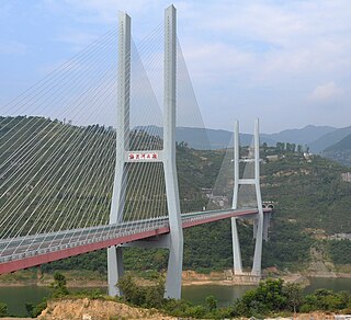
The Badong Yangtze River Bridge is a cable-stayed bridge over the Yangtze River in Badong County, Hubei, China. Completed in July 2004, it carries 4 lanes of traffic on China National Highway 209. The bridge's highest tower measures 218 metres (715 ft) and the bridge has a main span of 388 metres (1,273 ft). The bridge was constructed 147 metres (482 ft) above the original river however the reservoir created by the Three Gorges Dam has increased the height of the water below the bridge and the clearance is vastly reduced.

Sidi M'Cid Bridge is a 164 m long suspension bridge across the Rhumel River in Constantine, Algeria. It was opened to traffic in April 1912 and until 1929 was the highest bridge in the world at 175 m. The bridge was designed by French engineer Ferdinand Arnodin and links the Casbah to Sidi M'Cid hill. The bridge underwent restoration in 2000 when 12 of its cables were replaced by the Algerian company SAPTA.