
Cowlitz County is a county located in the U.S. state of Washington. As of the 2020 census, its population was 110,730. The county seat is Kelso, and its largest city is Longview. The county was formed in April 1854. Its name derives from the anglicized version of the Cowlitz Indian term Cow-e-liske, meaning either 'river of shifting sands' or 'capturing the medicine spirit.' Cowlitz comprises the Longview, WA Metropolitan statistical area, which is also included in the Portland-Vancouver-Salem, OR-WA Combined statistical area.
Rainier is a city in Columbia County, Oregon, United States. The city's population was 1,895 at the 2010 census. Rainier is on the south bank of the Columbia River across from Kelso and Longview, Washington.

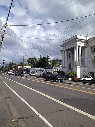
Longview is a city in Cowlitz County, Washington, United States. It is the principal city of the Longview, Washington Metropolitan Statistical Area, which encompasses all of Cowlitz County. Longview's population was 37,818 at the time of the 2020 census, making it the largest city in Cowlitz County. The city is located in southwestern Washington, at the junction of the Cowlitz and Columbia rivers. Longview shares a border with Kelso to the east, which is the county seat.

The Cowlitz River is a river in the state of Washington in the United States, a tributary of the Columbia River. Its tributaries drain a large region including the slopes of Mount Rainier, Mount Adams, and Mount St. Helens.

The Interstate Bridge is a pair of nearly identical steel vertical-lift, Parker through-truss bridges that carry Interstate 5 traffic over the Columbia River between Vancouver, Washington and Portland, Oregon in the United States.

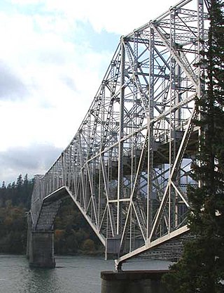
The Astoria–Megler Bridge is a steel cantilever through-truss bridge in the Pacific Northwest region of the United States that spans the lower Columbia River. It carries a section of U.S. Route 101 from Astoria, Oregon, to Point Ellice near Megler, Washington. Opened in 1966, it is the longest continuous truss bridge in North America.
The Bridge of the Gods is a steel truss cantilever bridge that spans the Columbia River between Cascade Locks, Oregon, and Washington state near North Bonneville. It is approximately 40 miles (64 km) east of Portland, Oregon, and 4 miles (6.4 km) upriver from Bonneville Dam. It is a toll bridge operated by the Port of Cascade Locks.

U.S. Route 30 (US 30) in the U.S. state of Oregon is a major east–west United States Numbered Highway that runs from its western terminus in Astoria to the Idaho border east of Ontario. West of Portland, US 30 generally follows the southern shore of the Columbia River; east of Portland, the highway has largely been replaced with Interstate 84 (I-84), though it is signed all the way across the state, and diverges from the I-84 mainline in several towns as a de facto business route. Out of all the states US 30 traverses, it spends the most time in Oregon. At 477.02 miles (767.69 km), it is also the longest road in the state.

The Hood River–White Salmon Interstate Bridge, or just the Hood River Bridge, is a truss bridge with a vertical lift that spans the Columbia River between Hood River, Oregon, and White Salmon, Washington. It connects Interstate 84/U.S. Route 30 on the Oregon side with Washington State Route 14.

This is a list of properties and historic districts in Washington that are listed on the National Register of Historic Places. There are at least three listings in each of Washington's 39 counties.

State Route 503 (SR 503) is a 54.11-mile-long (87.08 km) state highway serving Clark and Cowlitz counties in the U.S. state of Washington. The highway travels north from a short concurrency with SR 500 in Orchards through Battle Ground, the eastern terminus of SR 502, and communities in rural Clark County before crossing the Lewis River on the Yale Bridge. SR 503 intersects its spur route and turns west to parallel the Lewis River downstream to Woodland, where the highway ends at an interchange with Interstate 5 (I-5). The highway was part of the Lewis River Road, signed as State Road 15, from 1909 until 1919. The current route of SR 503 was split between Secondary State Highway 1S (SSH 1) from Woodland to Battle Ground and SSH 1U from Battle Ground to Orchards in 1937, combined to form SR 503 during the 1964 highway renumbering. A spur route, established in 1991, travels northeast into the Gifford Pinchot National Forest along Yale Lake, serving the community of Cougar.

State Route 432 (SR 432) is a 10.32-mile-long (16.61 km) state highway in the U.S. state of Washington, serving the cities of Longview and Kelso in Cowlitz County. The highway travels east along the Columbia River from an intersection with SR 4 in West Longview through the Port of Longview and the termini of SR 433 and SR 411 in Longview. SR 432 crosses the Cowlitz River on a divided highway and ends at an interchange with Interstate 5 (I-5) in Kelso. SR 432 was established during the 1964 highway renumbering as SR 832, replacing a branch of Primary State Highway 12 (PSH 12) that had been routed through Longview and Kelso since 1937. SR 432 was established in 1968 and originally routed on Nichols Boulevard within Longview and was re-aligned onto its current route in 1991 after the opening of Industrial Way.

U.S. Route 12 is a major east–west U.S. Highway, running from Aberdeen, Washington, to Detroit, Michigan. It spans 430.8 miles (693.3 km) across the state of Washington, making it the second longest highway in the state. It is also the only numbered highway to span the entire state from west to east, starting near the Pacific Ocean, and crossing the Idaho state line near Clarkston. It crosses the Cascade Range over White Pass, south of Mount Rainier National Park. Portions of it are concurrent with Interstate 5 (I-5) and Interstate 82 (I-82), although the majority of the route does not parallel any interstate highway.

State Route 433 is a 0.94-mile (1.51 km) long state highway located entirely in Cowlitz County, Washington, United States. The highway begins midway across the Columbia River on the National Register of Historic Places listed Lewis and Clark Bridge and travels north to SR 432 in Longview. Prior to the 1964 state highway renumbering the highway was part of Primary State Highway 12. Between 1964 and 1972, the highway's designation was changed from State Route 833 to the current SR 433.

The Pasco–Kennewick Bridge or Benton–Franklin Inter-County Bridge, known locally as the Green Bridge, was a steel cantilever truss bridge in the northwest United States. It crossed the Columbia River in central Washington, connecting Pasco and Kennewick, two of the Tri-Cities. Succeeded by the Cable Bridge in 1978, it was demolished in 1990.
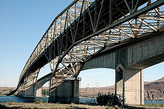
The Umatilla Bridge is the collective name for a pair of bridges in the northwest United States, carrying Interstate 82/U.S. Route 395 (I-82/US 395) across the Columbia River at the Washington–Oregon border. The older bridge opened in July 1955 and is a steel through truss cantilever bridge and carries southbound traffic. Northbound traffic and pedestrians travel on the newer concrete arch bridge, opened in 1988.
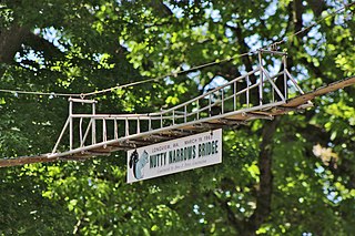
The Nutty Narrows Bridge is a squirrel bridge in Longview, Washington, United States. It spans Olympia Way near R. A. Long Park in downtown Longview, comprising a 60 feet (18 m) catenary bridge with a center section resembling a suspension bridge. The bridge was built by local contractor Amos Peters in 1963 and named by a city councilwoman, in a likely nod to the Tacoma Narrows Bridge.

The Yale Bridge or Lewis River Bridge spans the Lewis River near Yale, Washington. It was built in 1932 by Cowlitz and Clark counties. The suspension bridge has a clear span of 300 feet (91 m), with a total length of 532 feet (162 m), replacing a previous steel truss bridge at the site. Construction of the Ariel Dam had created Lake Merwin with a water depth of 90 feet (27 m) at the site, requiring a new bridge that did not need to have support piers in the water. The road deck, stiffened by a steel Warren truss, is 50 feet (15 m) above the high water line of the reservoir.
Northwest was a steamboat that operated on the Columbia, Cowlitz and lower Willamette rivers from 1889 to 1907. In 1907 Northwest was transferred to Alaska, where it sank on the Skeena River

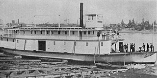
Joseph Kellogg was a stern-wheel driven steamboat that operated on the Willamette, Columbia, and Cowlitz rivers for the Kellogg Transportation Company. It was named after the company's founder, Joseph Kellogg (1812-1903). The sternwheeler Joseph Kellogg was built in 1881 at Portland, Oregon.


