Powhatan Point, Ohio

Last updated

Powhatan Point, Ohio
Main at Hopple, Powhatan Point.jpg
Houses on Main Street
OHMap-doton-Powhatan Point.png
Location of Powhatan Point, Ohio
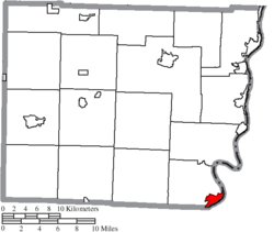
Map of Belmont County Ohio Highlighting Powhatan Point Village.png
Location of Powhatan Point in Belmont County
Coordinates: 39°51′55″N80°47′50″W / 39.86528°N 80.79722°W / 39.86528; -80.79722
Country United States
State Ohio
County Belmont
Township York
Area
[1]
  Total1.63 sq mi (4.23 km2)
  Land1.47 sq mi (3.81 km2)
  Water0.16 sq mi (0.42 km2)
Elevation
[2]
646 ft (197 m)
Population
 (2020)
  Total1,461
  Density993.88/sq mi (383.87/km2)
Time zone UTC-5 (Eastern (EST))
  Summer (DST) UTC-4 (EDT)
ZIP code
43942
Area code 740
FIPS code 39-64542 [3]
GNIS feature ID2399016 [2]

Powhatan Point is a village in southeastern Belmont County, Ohio, United States, along the Ohio River. The population was 1,461 at the 2020 census. It is part of the Wheeling metropolitan area.

Contents

While "Powhatan" likely memorializes the Native-American tribe of the same name, the "Point" in the town's name refers to the confluence between the Captina Creek and the Ohio River. Powhatan Point is the closest town on the Ohio side of Captina Island in the Ohio River.

History

Powhatan Point was platted in 1849. [4] A post office called Powhatan Point has been in operation since 1828. [5]

Geography

According to the United States Census Bureau, the village has a total area of 1.63 square miles (4.22 km2), of which 1.47 square miles (3.81 km2) is land and 0.16 square miles (0.41 km2) is water. [6]

Demographics

Historical population
CensusPop.Note
1880 225
1900 470
1910 415−11.7%
1920 406−2.2%
1930 2,329473.6%
1940 2,054−11.8%
1950 2,1353.9%
1960 2,1470.6%
1970 2,1670.9%
1980 2,1810.6%
1990 1,807−17.1%
2000 1,744−3.5%
2010 1,592−8.7%
2020 1,461−8.2%
U.S. Decennial Census [7]

2010 census

As of the census [8] of 2010, there were 1,592 people, 710 households, and 462 families living in the village. The population density was 1,083.0 inhabitants per square mile (418.1/km2). There were 792 housing units at an average density of 538.8 per square mile (208.0/km2). The racial makeup of the village was 98.7% White, 0.4% African American, 0.3% Native American, 0.1% Asian, 0.1% from other races, and 0.6% from two or more races. Hispanic or Latino of any race were 0.3% of the population.

There were 710 households, of which 28.3% had children under the age of 18 living with them, 45.4% were married couples living together, 15.2% had a female householder with no husband present, 4.5% had a male householder with no wife present, and 34.9% were non-families. 30.6% of all households were made up of individuals, and 13.9% had someone living alone who was 65 years of age or older. The average household size was 2.24 and the average family size was 2.74.

The median age in the village was 43.6 years. 21.4% of residents were under the age of 18; 8% were between the ages of 18 and 24; 22.4% were from 25 to 44; 30.6% were from 45 to 64; and 17.5% were 65 years of age or older. The gender makeup of the village was 47.8% male and 52.2% female.

2000 census

As of the census [3] of 2000, there were 1,744 people, 760 households, and 515 families living in the village. The population density was 1,119.7 inhabitants per square mile (432.3/km2). There were 830 housing units at an average density of 532.9 per square mile (205.8/km2). The racial makeup of the village was 98.11% White, 0.57% African American, 0.06% Native American, and 1.26% from two or more races. Hispanic or Latino of any race were 0.23% of the population.

There were 760 households, out of which 27.5% had children under the age of 18 living with them, 52.9% were married couples living together, 11.1% had a female householder with no husband present, and 32.2% were non-families. 28.2% of all households were made up of individuals, and 14.9% had someone living alone who was 65 years of age or older. The average household size was 2.29 and the average family size was 2.78.

In the village, the population was spread out, with 21.3% under the age of 18, 8.5% from 18 to 24, 27.1% from 25 to 44, 25.6% from 45 to 64, and 17.5% who were 65 years of age or older. The median age was 41 years. For every 100 females, there were 90.0 males. For every 100 females age 18 and over, there were 83.8 males.

The median income for a household in the village was $24,875, and the median income for a family was $32,546. Males had a median income of $32,039 versus $16,583 for females. The per capita income for the village was $14,570. About 16.7% of families and 19.8% of the population were below the poverty line, including 27.2% of those under age 18 and 16.2% of those age 65 or over.

Economy

Although the village's economy was once largely supported by the coal industry, most residents currently seek employment outside village limits in nearby towns and cities such as Moundsville and Wheeling, West Virginia.

Education

Powhatan Point currently has a K–8 elementary school. After elementary promotion, the majority of students attend River High School, located in Hannibal, a school that also draws students from other small Ohio River villages, such as Clarington, Sardis, Hannibal, and Cameron.

Powhatan Point has a public library, a branch of the Belmont County District Library. [9]

See also

Related Research Articles

<span class="mw-page-title-main">Belmont County, Ohio</span> County in Ohio, United States

Belmont County is a county in the U.S. state of Ohio. As of the 2020 United States census, the population was 66,497. Its county seat is St. Clairsville, while its largest city is Martins Ferry. The county was created on September 7, 1801, and organized on November 7, 1801. It takes its name from the French for "beautiful mountain".

<span class="mw-page-title-main">Belmont, Ohio</span> Village in Ohio, United States

Belmont is a village in central Belmont County, Ohio, United States. The population was 414 at the 2020 census. It is part of the Wheeling metropolitan area.

<span class="mw-page-title-main">Bridgeport, Ohio</span> Village in Ohio, United States

Bridgeport is a village in eastern Belmont County, Ohio, United States. It lies across the Ohio River from Wheeling, West Virginia, at the mouth of Wheeling Creek and is connected by two bridges to Wheeling Island. The population was 1,582 at the 2020 census. It is part of the Wheeling metropolitan area.

<span class="mw-page-title-main">Flushing, Ohio</span> Village in Ohio, United States

Flushing is a village in Belmont County, Ohio, United States. The population was 830 at the 2020 census.

<span class="mw-page-title-main">Morristown, Ohio</span> Village in Ohio, United States

Morristown is a village in Belmont County, Ohio, United States. The population was 248 at the 2020 census. It is part of the Wheeling metropolitan area.

<span class="mw-page-title-main">Shadyside, Ohio</span> Village in Ohio, United States

Shadyside is a village in eastern Belmont County, Ohio, United States, along the Ohio River. The population was 3,454 at the 2020 census. It is part of the Wheeling metropolitan area.

<span class="mw-page-title-main">Cleves, Ohio</span> City in Ohio, United States

Cleves is a village in Miami Township, Hamilton County, Ohio, United States. Located along the Ohio River, it is a western suburb of Cincinnati. The population was 3,414 at the 2020 census.

<span class="mw-page-title-main">Proctorville, Ohio</span> Village in Ohio, United States

Proctorville is a village in Lawrence County, Ohio, United States, along the Ohio River. The population was 523 at the 2020 census. The East End Bridge connects Proctorville to Huntington, West Virginia across the Ohio River.

<span class="mw-page-title-main">Grafton, Ohio</span> Village in Ohio, United States

Grafton is a village in Lorain County, Ohio, United States, along the East Branch of the Black River. The population was 5,895 at the 2020 census. The Lorain Correctional Institution and several other prisons are located in and near Grafton.

<span class="mw-page-title-main">Covington, Ohio</span> Village in Ohio, United States

Covington is a village in Miami County, Ohio, United States. The population was 2,548 at the 2020 census. It is part of the Dayton Metropolitan Statistical Area. The village was incorporated as Covington in 1835 on the site of the 1793 Fort Rowdy.

<span class="mw-page-title-main">Beallsville, Ohio</span> Village in Ohio, United States

Beallsville is a village in Monroe County, Ohio, United States. As of the 2020 census, the population was 355. The village gained national attention by losing more than 1% of its population killed in action in the Vietnam War, the worst per-capita loss of life experienced by any place in the country.

<span class="mw-page-title-main">Woodsfield, Ohio</span> Village in Ohio, United States

Woodsfield is a village and the county seat of Monroe County, Ohio, United States, located about 30 miles (48 km) northeast of Marietta. The population was 2,210 at the 2020 census.

<span class="mw-page-title-main">Cloverdale, Ohio</span> Village in Ohio, United States

Cloverdale is a village in Perry Township, Putnam County, Ohio, United States. The population was 170 at the 2020 census.

<span class="mw-page-title-main">Port Jefferson, Ohio</span> Village in Ohio, United States

Port Jefferson is a village in Salem Township, Shelby County, Ohio, United States. The population was 308 at the 2020 census.

<span class="mw-page-title-main">Middle Point, Ohio</span> Village in Ohio, United States

Middle Point is a village in Van Wert County, Ohio, United States. The population was 566 at the 2020 census. It is included within the Van Wert, Ohio Micropolitan Statistical Area.

<span class="mw-page-title-main">Matamoras, Ohio</span> Village in Ohio, United States

Matamoras, also known as New Matamoras, is a village in Washington County, Ohio, United States, along the Ohio River. The population was 702 at the 2020 census. It is part of the Marietta micropolitan area.

<span class="mw-page-title-main">Belmont, West Virginia</span> Town in West Virginia, United States

Belmont is a town in Pleasants County, West Virginia, United States. It is part of the Parkersburg–Vienna metropolitan area. The population was 872 at the 2020 census. Belmont was incorporated on April 19, 1946, by the Circuit Court of Pleasants County. The city was named for the beautiful hills in the area.

<span class="mw-page-title-main">Yorkville, Ohio</span> Village in Ohio, United States

Yorkville is a village in Belmont and Jefferson counties in the U.S. state of Ohio. The population was 968 at the 2020 census. Yorkville lies within two Metropolitan Statistical Areas; the Belmont County portion is part of the Wheeling metropolitan area, while the Jefferson County portion is part of the Weirton–Steubenville metropolitan area.

<span class="mw-page-title-main">Adena, Ohio</span> Village in Ohio, United States

Adena is a village in southwestern Jefferson and southeastern Harrison counties in the U.S. state of Ohio. The population was 664 at the 2020 census. It is part of the Weirton–Steubenville metropolitan area.

<span class="mw-page-title-main">Tremont City, Ohio</span> Village in Ohio, United States

Tremont City is a village in Clark County, Ohio, United States. The population was 352 at the 2020 census. The village is part of the Springfield, Ohio Metropolitan Statistical Area.

References

  1. "ArcGIS REST Services Directory". United States Census Bureau. Retrieved September 20, 2022.
  2. 1 2 U.S. Geological Survey Geographic Names Information System: Powhatan Point, Ohio
  3. 1 2 "U.S. Census website". United States Census Bureau . Retrieved January 31, 2008.
  4. Caldwell, John Alexander (1880). History of Belmont and Jefferson Counties, Ohio: And Incidentally Historical Collections. Historical Publishing Company. p.  419.
  5. "Belmont County". Jim Forte Postal History. Retrieved January 2, 2016.
  6. "US Gazetteer files 2010". United States Census Bureau. Archived from the original on January 25, 2012. Retrieved January 6, 2013.
  7. "Census of Population and Housing". Census.gov. Retrieved June 4, 2015.
  8. "U.S. Census website". United States Census Bureau . Retrieved January 6, 2013.
  9. "Locations & Hours". Belmont County District Library. Retrieved February 25, 2018.