Maynard, Ohio

Last updated

Location of Maynard, Ohio OHMap-doton-Maynard.png
Location of Maynard, Ohio

Maynard is an unincorporated community located in western Colerain Township, Belmont County, Ohio, United States, along Wheeling Creek. [1] [2] It has a post office with the ZIP code 43937. [3]

Contents

Maynard is part of the Wheeling, WV-OH Metropolitan Statistical Area. Maynard is a part of the St. Clairsville-Richland City School District.

The community is near Wheeling Township and its sister community of Blainesville.

Name origin

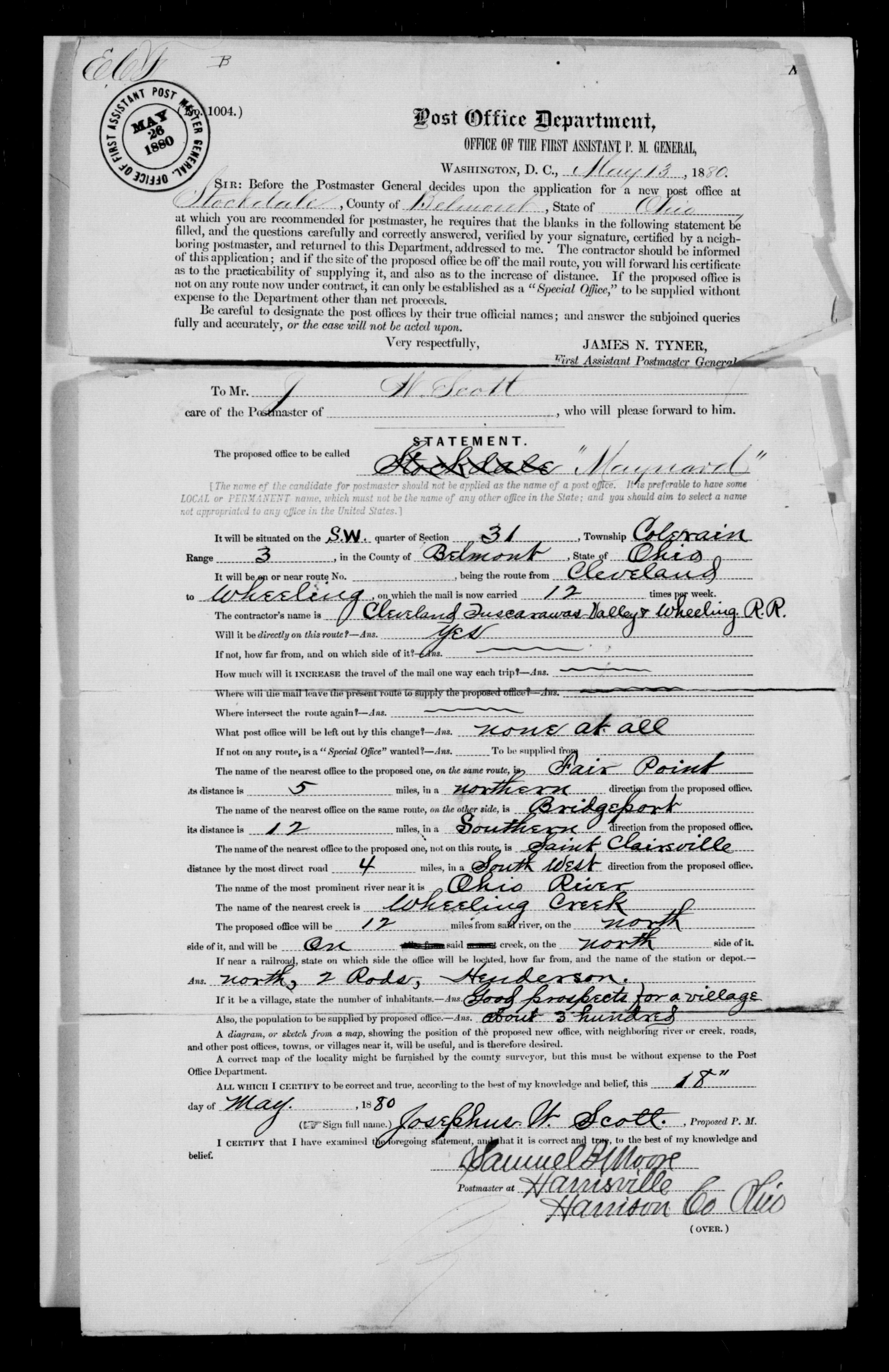
Maynard was named for Postmaster General Horace Maynard, [4] who would serve under President Rutherford B. Hayes when the community would apply for its post office in 1880. [5] While serving as a Representative from Tennessee, Maynard had visited the county seat St. Clairsville stumping on behalf of President Andrew Johnson and his policies while on the Swing Around the Circle campaign nearly fifteen years before the Post Office's naming.

Until its postal application, the rail stop was called Henderson's Station after the Henderson family. Undoubtedly, Maynard would have been named Henderson if the name had not already been in use. A short-lived mail stop on the St. Clairsville-Cadiz Pike (today State Route 9) in Belmont County near the border with Harrison County was named Henderson in 1877 after its postmaster. [6] Stockdale was proposed as a name for the community, but upon the recent news of Horace Maynard's appointment to President Hayes' cabinet, the current name was selected. [7] [8]

History

The Maynard area saw initial development as Henderson's Station as a stop on the Cleveland, Tuscarawas Valley & Wheeling Railway. Purchased by the Cleveland, Lorain and Wheeling Railway in 1875, the line was still frequently referred to as the Tuscarawas Valley (T.V.) line. Maynard saw substantial growth as coal works were mined, commencing around the time its post office was established through the 1920s. Railroad executive and coal mine owner Selah Chamberlain purchased land and developed a grouping of 77 company houses on a hill above Maynard, which would be called New Pittsburgh in 1883. [9] In 1916, statistics show Maynard to have 1,588 adults and 259 children members at St. Stanislaus Catholic Church alone. [10]

Notable person

Related Research Articles

<span class="mw-page-title-main">Tippecanoe, Ohio</span> Census-designated place in Ohio, United States

Tippecanoe is an unincorporated community and census-designated place (CDP) in central Washington Township, Harrison County, Ohio, United States. It is located along State Route 800 in the valley of Stillwater Creek, a north-flowing tributary of the Tuscarawas River. It had a post office until 2011 with the ZIP code 44699. The population was 83 at the 2020 census.

<span class="mw-page-title-main">Lafferty, Ohio</span> Unincorporated community in Ohio, United States

Lafferty is a census-designated place in northeastern Union Township, Belmont County, Ohio, United States, along Wheeling Creek. As of the 2020 census it had a population of 255. It has a post office with the ZIP code 43951.

<span class="mw-page-title-main">Glencoe, Ohio</span> Unincorporated community in Ohio, United States

Glencoe is a census-designated place in southern Richland Township, Belmont County, Ohio, United States. As of the 2020 census it had a population of 264. It has a post office with the ZIP code 43928.

<span class="mw-page-title-main">Fairpoint, Ohio</span> Unincorporated community in Ohio, U.S.

Fairpoint is an unincorporated community in eastern Wheeling Township, Belmont County, Ohio, United States, along Wheeling Creek. Although it is unincorporated, and at one point had a post office which was closed in recent years, with the ZIP code 43927. It lies along State Route 9.

<span class="mw-page-title-main">Colerain, Ohio</span> Unincorporated community in Ohio, U.S.

Colerain is an unincorporated community in eastern Colerain Township, Belmont County, Ohio, United States. It has a post office with the ZIP code 43916. It lies along U.S. Route 250.

<span class="mw-page-title-main">Blaine, Ohio</span> U.S. city in Ohio

Blaine is an unincorporated community in northern Pease Township, Belmont County, Ohio, United States. It is located along Wheeling Creek. It has a post office with the ZIP code 43909.

<span class="mw-page-title-main">Barton, Ohio</span> Unincorporated community in Ohio, U.S.

Barton is an unincorporated community in southern Colerain Township, Belmont County, Ohio, United States, along Wheeling Creek. It has a post office with the ZIP code 43905.

<span class="mw-page-title-main">Bannock, Ohio</span> Unincorporated community in Ohio, United States

Bannock is a census-designated place in northwestern Richland Township, Belmont County, Ohio, United States, along Wheeling Creek. As of the 2020 census it had a population of 159. It has a post office with the ZIP code 43972. It lies along State Route 331.

<span class="mw-page-title-main">Mount Liberty, Ohio</span> Unincorporated community in Ohio, U.S.

Mount Liberty is an unincorporated community on the border between the Milford and Liberty Townships of Knox County, Ohio, United States. It has a post office with the ZIP code 43048. It lies along the concurrent U.S. Route 36 and State Route 3.

<span class="mw-page-title-main">North Georgetown, Ohio</span> Unincorporated community in Ohio, U.S.

North Georgetown is an unincorporated community in western Knox Township, Columbiana County, Ohio, United States. Although unincorporated, it has a post office, with the ZIP code of 44665. The town itself is located at the intersection of Georgetown Road and Rochester Road.

<span class="mw-page-title-main">East Rochester, Ohio</span> Census-designated place in Ohio, United States

East Rochester is an unincorporated community and census-designated place (CDP) in southern West Township, Columbiana County, Ohio, United States. The population was 224 as of the 2020 census. It lies along U.S. Route 30, and has a post office with the ZIP code 44625. It is a part of the Salem micropolitan area, about 20 miles (32 km) east of Canton.

<span class="mw-page-title-main">Sandyville, Ohio</span> CDP in Ohio, United States

Sandyville is an unincorporated community and census-designated place in northern Sandy Township, Tuscarawas County, Ohio, United States. It has a post office with the ZIP code 44671. It lies along State Route 800 between Canton and New Philadelphia. The population was 350 at the 2020 census.

<span class="mw-page-title-main">Somerdale, Ohio</span> Unincorporated community in Ohio, U.S.

Somerdale is an unincorporated community in northeastern Fairfield Township, Tuscarawas County, Ohio, United States. It has a post office with the ZIP code 44678. It lies along State Route 212, Conotton Creek and the Wheeling and Lake Erie Railway east of Zoar.

Lock Seventeen is an unincorporated community in Tuscarawas County, in the U.S. state of Ohio.

Gilmore is an unincorporated community in Washington Township, Tuscarawas County, Ohio, south of the village of Gnadenhutten. Gilmore sits on Tuscarawas County Road 10 and is intersected by Tuscarawas County Road 14 at Gilmore's square.

Pleasant Grove is an unincorporated community in Belmont County, in the U.S. state of Ohio.

Barrs Mills is an unincorporated community in Tuscarawas County, in the U.S. state of Ohio.

Postboy is an unincorporated community in Tuscarawas County, in the U.S. state of Ohio.

Guernsey is an unincorporated community in Guernsey County, in the U.S. state of Ohio.

Middlebourne is an unincorporated community in Guernsey County, in the U.S. state of Ohio.

References

  1. "Maynard, Ohio". Geographic Names Information System . United States Geological Survey, United States Department of the Interior.
  2. Ohio Atlas & Gazetteer. Yarmouth, Maine: DeLorme. 1991. pp. 62–63. ISBN   0-89933-233-1.
  3. USPS – Cities by ZIP Code
  4. Overman, William Daniel (1958). Ohio Town Names. Akron, OH: Atlantic Press. p. 85.
  5. Hunt, W. J. (October 26, 1882). "editor". The Belmont Chronicle. 22 (42): 3.
  6. Hunt, W. A. (February 22, 1877). "editor". The Belmont Chronicle. 17 (6): 3.
  7. Overman, William Daniel (1958). Ohio Town Names. Akron, OH: Atlantic Press. p. 85.
  8. https://s3.amazonaws.com/NARAprodstorage/lz/dc-metro/rg-028/M1126/M1126-447/M1126-447-0854.jpg [ bare URL image file ]
  9. Hunt, W. J. (June 7, 1883). "editor". The Belmont Chronicle. 23 (23): 2.
  10. Centennial. Unknown: Taylor. 1989. pp. 20–26.

40°07′24″N80°52′45″W / 40.12333°N 80.87917°W / 40.12333; -80.87917