The Manchester Bolton & Bury Canal is a disused canal in Greater Manchester, England, built to link Bolton and Bury with Manchester. The canal, when fully opened, was 15 miles 1 furlong (24 km) long. It was accessed via a junction with the River Irwell in Salford. Seventeen locks were required to climb to the summit as it passed through Pendleton, heading northwest to Prestolee before it split northwest to Bolton and northeast to Bury. Between Bolton and Bury the canal was level and required no locks. Six aqueducts were built to allow the canal to cross the rivers Irwell and Tonge and several minor roads.

The canal network of the United Kingdom played a vital role in the Industrial Revolution. The UK was the first country to develop a nationwide canal network which, at its peak, expanded to nearly 4,000 miles in length. The canals allowed raw materials to be transported to a place of manufacture, and finished goods to be transported to consumers, more quickly and cheaply than by a land based route. The canal network was extensive and included feats of civil engineering such as the Anderton Boat Lift, the Manchester Ship Canal, the Worsley Navigable Levels and the Pontcysyllte Aqueduct.

The Huddersfield Narrow Canal is an inland waterway in northern England. It runs just under 20 miles (32 km) from Lock 1E at the rear of the University of Huddersfield campus, near Aspley Basin in Huddersfield, to the junction with the Ashton Canal at Whitelands Basin in Ashton-under-Lyne. It crosses the Pennines by means of 74 locks and the Standedge Tunnel.

The canals of the United Kingdom are a major part of the network of inland waterways in the United Kingdom. They have a varied history, from use for irrigation and transport, through becoming the focus of the Industrial Revolution, to today's role of recreational boating. Despite a period of abandonment, today the canal system in the United Kingdom is again increasing in use, with abandoned and derelict canals being reopened, and the construction of some new routes. Canals in England and Wales are maintained by navigation authorities. The biggest navigation authorities are the Canal & River Trust and the Environment Agency, but other canals are managed by companies, local authorities or charitable trusts.

The Barton Swing Aqueduct is a moveable navigable aqueduct in Barton upon Irwell, Greater Manchester, England. It carries the Bridgewater Canal across the Manchester Ship Canal. The swinging action allows large vessels using the ship canal to pass through and smaller craft, both narrowboats and broad-beam barges, to cross over the top. The aqueduct, the first and only swing aqueduct in the world, is a Grade II* listed building, and considered a major feat of Victorian civil engineering. Designed by Sir Edward Leader Williams and built by Andrew Handyside and Company of Derby, the swing bridge opened in 1894 and remains in regular use.

Marple Aqueduct at Marple, Greater Manchester, in north-west England was built to carry the lower level of the Peak Forest Canal across the River Goyt.

Little Lever is a village in the Metropolitan Borough of Bolton, Greater Manchester, England. Within the Historic County of Lancashire, it is 2 miles (3.2 km) southeast of Bolton, 2 miles (3.2 km) west of Radcliffe and 4 miles (6.4 km) southwest of Bury. In the 19th century, the population was employed in cotton mills, paper mills, bleach works, terracotta works, a rope works and numerous collieries.

Navigable aqueducts are bridge structures that carry navigable waterway canals over other rivers, valleys, railways or roads. They are primarily distinguished by their size, carrying a larger cross-section of water than most water-supply aqueducts. Roman aqueducts were used to transport water and were created in Ancient Rome. The 662-metre (2,172 ft) long steel Briare aqueduct carrying the Canal latéral à la Loire over the River Loire was built in 1896. It was ranked as the longest navigable aqueduct in the world for more than a century, until the Magdeburg Water Bridge in Germany took the title in the early 21st century.

Prestolee is a small village in Kearsley, within the Metropolitan Borough of Bolton, in Greater Manchester, England. It lies on the River Irwell and is one of a cluster of villages between Bolton and Kearsley, which includes Stoneclough and Ringley.

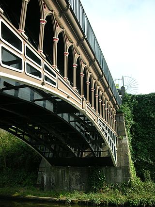
Clifton Aqueduct, built in 1796, carried the Manchester, Bolton and Bury Canal across the River Irwell in Clifton, near Manchester, England. It is preserved as a Grade II listed structure. The aqueduct is constructed of dressed stone with brick arches. Three segmental arches with keystones rest on triangular-ended cutwaters. Above the cutwaters are flat Pilasters. A C20 brick parapet remains on the eastern side. There is a towpath on each side, and the aqueduct contains grooves for stop planks to be inserted, to drain the canal. The aqueduct was engineered by Charles Roberts and John Nightingale.

The Store Street Aqueduct in central Manchester, England, was built in 1798 by Benjamin Outram on the Ashton Canal. A Grade II* listed building, it is built on a skew of 40° across Store Street, and is believed to be the first major aqueduct of its kind in Great Britain and the oldest still in use today.

The Manchester and Salford Junction Canal was a canal in the city of Manchester. It was originally built to provide a direct waterway between the Mersey and Irwell Navigation and the Rochdale Canal. The canal opened in 1839 and was abandoned in 1922.
The Engine Arm Aqueduct near Smethwick, West Midlands, England, was built in 1825 by Thomas Telford to carry a water feeder, the Engine Arm, from Edgbaston Reservoir over the BCN New Main Line canal to the adjacent and parallel Old Main Line. The structure is maintained by the Canal & River Trust. It is a Scheduled Ancient Monument and is Grade II* listed.

Fletcher's Canal was a 1.5-mile (2.4 km) long canal in Greater Manchester, which connected the Wet Earth Colliery to the Manchester, Bolton & Bury Canal at Clifton Aqueduct. The canal is now derelict and no longer used.
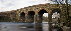
Clifton Viaduct is a Grade II listed stone structure crossing the valley of the River Irwell in Clifton, Greater Manchester, and also the Manchester, Bolton and Bury Canal. It is known locally as the "13 Arches". It is currently disused and closed to the public.
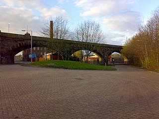
Daisyfield Viaduct is a stone structure crossing the Manchester, Bolton and Bury Canal and River Irwell in Bury, Greater Manchester, England. It no longer carries trains, and is now used as a recreational feature for the general public.

Semington Aqueduct is an aqueduct at Semington, Wiltshire, England, UK. It carries the Kennet and Avon Canal over the Semington Brook.

The Lune Aqueduct is a navigable aqueduct that carries the Lancaster Canal over the River Lune, on the east side of the city of Lancaster in Lancashire, England. It was completed in 1797 at a total cost of £48,320 18s 10d. It is a Grade I listed building.
Kearsley is a town and an unparished area in the Metropolitan Borough of Bolton, Greater Manchester, England, and it includes the area of Ringley and the village of Prestolee. The town contains 21 listed buildings that are recorded in the National Heritage List for England. Of these, one is listed at Grade II*, the middle of the three grades, and the others are at Grade II, the lowest grade. The Manchester and Bolton Railway was built through the area, and two railway bridges are listed. Also passing through the area are the Manchester Bolton and Bury Canal, which is now disused, and the River Irwell; listed buildings associated with these are bridges, an aqueduct, and milestones. The other listed buildings include a set of stocks, a house later used as a social club, two churches, a tower remaining from a demolished church, and a former spinning mill.
Little Lever is a village and an unparished area in the Metropolitan Borough of Bolton, Greater Manchester, England. It contains eight listed buildings that are recorded in the National Heritage List for England. All the listed buildings are designated at Grade II, the lowest of the three grades, which is applied to "buildings of national importance and special interest". The Manchester Bolton & Bury Canal, now disused, passes through the area, and four milestones and a post adjacent to it are listed. The other listed buildings are a house, originally serving Ladyshore Colliery, a church, and a war memorial plaque.