
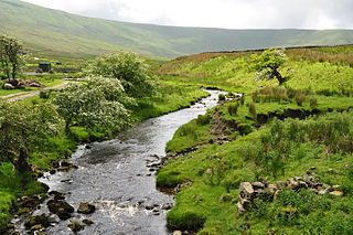
The River Wharfe is a river in Yorkshire, England originating within the Yorkshire Dales National Park. For much of its middle course it is the county boundary between West Yorkshire and North Yorkshire. Its valley is known as Wharfedale.

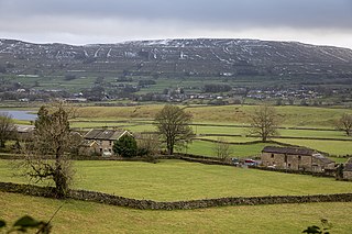
Wharfedale is the valley of the upper parts of the River Wharfe and one of the Yorkshire Dales. It is situated in North Yorkshire, and the cities of Leeds and Bradford in West Yorkshire. It is the upper valley of the River Wharfe. Towns and villages in Wharfedale include Buckden, Kettlewell, Conistone, Grassington, Hebden, Bolton Abbey, Addingham, Ilkley, Burley-in-Wharfedale, Otley, Pool-in-Wharfedale, Arthington, Collingham and Wetherby. Beyond Wetherby, the valley opens out and becomes part of the Vale of York.

Grassington is a village and civil parish in North Yorkshire, England. The population of the parish at the 2011 Census was 1,126. Historically part of the West Riding of Yorkshire, the village is situated in Wharfedale, about 8 miles (10 km) north-west from Bolton Abbey, and is surrounded by limestone scenery. Nearby villages include Linton, Threshfield, Hebden, Conistone and Kilnsey.
Malham is a village and civil parish in the Craven district of North Yorkshire, England. Before 20th century boundary changes, the village was part of the Settle Rural District, in the historic West Riding of Yorkshire. In the Domesday Book, the name is given as Malgun, meaning "settlement by the gravelly places". In 2001 the parish had a population of approximately 150. Malham parish increased in size geographically and so at the 2011 Census had a population of 238.

The River Dibb, also known as Barben Beck, is a small river located in North Yorkshire, England. It is a tributary of the River Wharfe. Grimwith Reservoir is at the head of the River Dibb at a point some 2.5 miles (4 km) from Appletreewick. The river flows for 5.2 kilometres (3.2 mi), and must maintain a flow of 273,000 cubic metres (9,600,000 cu ft) of water a day into the River Wharfe system.

Conistone is a small village in the Craven district of North Yorkshire, England. It lies 3 miles (5 km) north of Grassington, 3 miles (5 km) south of Kettlewell and 12 miles (19 km) north of Skipton beside the River Wharfe, in Upper Wharfedale.
Calver Hill is a fell in the Yorkshire Dales National Park in North Yorkshire, England. It is composed of limestone and is situated at grid reference NZ012003, near where the valleys of Swaledale and Arkengarthdale meet, the village of Reeth is located on its lower south-eastern slopes, it reaches an altitude of 487 metres (1,598 ft) and is a distinguished feature in mid Swaledale. Calver Hill is an area of grouse shooting and the fell is dotted with grouse butts. Most of the drainage from the fell goes north and easterly to join the Arkle Beck in lower Arkengarthdale which eventually joins the River Swale just south of Reeth.
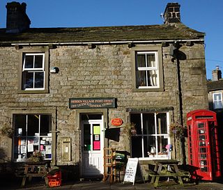
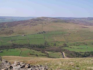
Hebden is a village and civil parish in the Craven District of North Yorkshire, England, and one of four villages in the ecclesiastical parish of Linton. It lies near Grimwith Reservoir and Grassington, in Wharfedale in the Yorkshire Dales National Park. In 2011 it had a population of 246.

Mossdale Caverns is a cave system in the Yorkshire Dales, England. It is about 5 kilometres (3.1 mi) north of Grassington, and east of Conistone, where Mossdale Beck sinks at the base of Mossdale Scar. It lies at an altitude of 425 metres (1,394 ft) on the eastern flank of Wharfedale, and extends south-east beneath Grassington Moor.
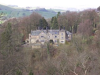
Hartlington is a small village and civil parish in the Craven district of North Yorkshire, England. At the 2011 Census, the population of the parish was around 50. Details are included in the civil parish of Hebden, North Yorkshire. It is under a mile east from the nearby village of Burnsall, which can be reached by going down Cross Hill. Hartlington is also just over a mile west of the village of Appletreewick. It is around 4 miles south-east of the small town of Grassington, and can be reached by going through the village of Hebden. Hartlington Raikes, one of the main roads in Hartlington, goes from Lower Hartlington to Upper Hartlington, to the B6265 approximately 1.5 miles away. The road then turns into Hartlington Moor Lane, which goes up to Grimwith Reservoir.

Linton Falls Hydro is a hydroelectric generating power station located on the Linton Falls Weir of the River Wharfe, near Grassington, North Yorkshire, England. The power station is located on the same site as a hydroelectric scheme that was first opened in 1909, but had closed by 1948. The new scheme, which opened in March 2012, uses the original building which is now a scheduled monument.

Fleet Moss is a upland area separating Wharfedale from Wensleydale in North Yorkshire, England. The area is 1,850 ft (560 m) above sea level. Fleet Moss is noted for its peat blanket bog, which has been dated to the Neolithic period. The area is ombrotrophic; this means it needs rain, hail snow and fog for its nutrients. Fleet Moss is known as the most eroded blanket bog in all of Yorkshire; because of its observable damage, it is known colloquially as The Somme, and as such, is visible from space.

Upper Barden Reservoir is an upland fresh water reservoir, one of two reservoirs that collect water from Barden Moor, and dam Barden Beck, a tributary of the River Wharfe in the Yorkshire Dales, North Yorkshire, England. The reservoir was opened in 1882 and also supplies fresh water to the Nidd Aqueduct, which transports it to Bradford. Upper Barden Reservoir was the second of the reservoirs to be built,.

Crummackdale,, is a small valley north of the village of Austwick in the Craven District of North Yorkshire, England. The Valley is drained by Austwick Beck, which flows into the River Wenning, which in turn heads westwards to empty into the Irish Sea. Crummackdale is a narrow south west facing dale, at the south west corner of the Yorkshire Dales National Park.
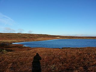
Fountains Fell Tarn, is an upland lake between the two peaks of Fountains Fell, in North Yorkshire, England. The tarn is close to the Pennine Way, some 4.3 miles (7 km) north west of Malham Tarn, and 4.3 miles (7 km) east of Horton in Ribblesdale. Water from the tarn flows eastwards through Cowside Beck, which is a tributary of the River Skirfare in Littondale. Whilst the water in the lake is acidic, as it runs off the mountain, it flows over Yoredale beds limestone and so becomes a harder water.

Scoska Wood is an IUCN Category IV – habitat or species management area, a British national nature reserve (NNR), and a Site of Special Scientific Interest (SSSI) in Littondale, North Yorkshire, England. It is a managed ancient woodland, known for its ash trees, grasses and moths. It was designated as an SSSI in 1975, and was awarded its IUCN status in 1992.
Wether Fell, also known as Drumaldrace, is a mountain in the Yorkshire Dales National Park, in North Yorkshire, England. Wether Fell is mountain that divides Wensleydale in the north and Upper Wharfedale in the south. Its summit is 614 metres (2,014 ft). A Roman Road, the Cam High Road, passes along the southern edge of the summit reaching 1,900 feet (580 m).
Snaizeholme is a small side valley of Wensleydale in the Yorkshire Dales National Park (YDNP), North Yorkshire, England. The valley is noted for its red squirrel reserve, the only place within the North Yorkshire part of the Yorkshire Dales National Park where red squirrels are known to live, and a tree re-wilding project.


