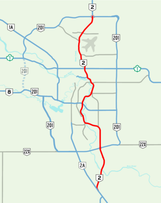
Deerfoot Trail is a 46.4-kilometre (28.8 mi) freeway segment of Highway 2 in Calgary, Alberta, Canada. It stretches the entire length of the city from south to north and links suburbs to downtown via Memorial Drive and 17 Avenue SE. The freeway begins south of Calgary where it splits from Macleod Trail, crosses the Bow River into city limits, and reaches the Stoney Trail ring road. Crisscrossing twice more with the river, it intersects Glenmore Trail and Memorial Drive; the former is a major east–west expressway while the latter is a freeway spur into downtown. In north Calgary, it crosses Highway 1 and passes Calgary International Airport before ending at a second interchange with Stoney Trail. Highway 2 becomes the Queen Elizabeth II Highway as it continues north into Rocky View County towards Edmonton.

The Plus 15 or +15 is a Skyway network in Calgary, Alberta. It is the world's most extensive pedestrian skywalk system, with a total length of 16 kilometres and 86 bridges connecting 130 buildings as of 2022. Calgary often has severe winters and the walkways allow people to get around the city's downtown more quickly and comfortably. The busiest parts of the network saw over 20,000 pedestrians per day in a 2018 count.

Inglewood is an urban neighbourhood in central Calgary, Alberta, Canada, centred on 9th Avenue SE for several blocks east of the Elbow River and downtown. It also contains the Business Revitalization Zone of Inglewood.

The neighbourhood of Eau Claire in Calgary, Alberta, Canada is located immediately north of Downtown, and south of the Bow River and north of 4th Avenue. A mix of riverside condominiums, shopping, restaurants, hotels, a large public plaza and urban parkland make Eau Claire one of Calgary's most popular areas. Contained within Eau Claire is the city's Festival District.

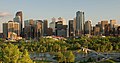
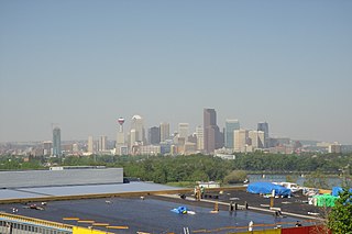
Downtown Calgary is a dense urban district in central Calgary, Alberta. It contains the second largest concentration of head offices in Canada, despite only being the country's fourth largest city in terms of population. The downtown is divided into several residential, commercial, corporate, and mixed-use neighbourhoods, including the Financial District (CBD), Eau Claire, Chinatown, East Village, Beltline, and the West End.
Parkdale is a mature, inner city neighbourhood in the city of Calgary, Alberta along the north bank of the Bow River between the communities of West Hillhurst and Point McKay. It is bounded on the south by the Bow River, 28 St NW to the east, Shaganappi Trail NW to the west and on the north by 16th Avenue. Parkdale is in close proximity to both the Foothills Medical Centre and the Alberta Children's Hospital constructed in 2006, as well as the University of Calgary. Memorial Drive provides access to downtown Calgary and to Highway 1 which leads to the Rocky Mountains. Parkdale was annexed to the City of Calgary in 1910 when Calgary began to experience a "major economic and building boom." The boom ended in 1913 and further development of the Parkdale Addition as it was called, was halted because of World War I. Following World War II in the 1950s the dominant housing type that characterized Parkdale, was the bungalow. By 2014 Parkdale, like other inner city communities in Calgary, was experiencing gradual gentrification with small cottage-style bungalows being replaced by spacious flat roofed, Prairie School Frank Lloyd Wright inspired infills attracting young families with children away from the long commute suburbs to inner city ease of access to downtown, transit and work.
Crowchild Trail is a major expressway in western Calgary, Alberta. The segment from the 12 Mile Coulee Road at the edge of the city to 16 Avenue NW is designated as Highway 1A by Alberta Transportation. The road is a critical north-south link in West Calgary for both downtown bound traffic and travel between the two quadrants of the city it passes through. Although planned to be one single freeway from Glenmore Trail to the city limits, the route is currently divided by a section of slow moving arterial road with four signalized intersections between 24 Avenue and Memorial Drive. This causes the freeway in the northwest to separated from the freeway south of the Bow River. Filling the gap and making the whole route a minimum six lane freeway is currently planned for construction beyond 2027.
The city of Calgary, Alberta, has a large transportation network that encompasses a variety of road, rail, air, public transit, and pedestrian infrastructure. Calgary is also a major Canadian transportation centre and a central cargo hub for freight in and out of north-western North America. The city sits at the junction between the "Canamex" highway system and the Trans-Canada Highway.

Spray Valley Provincial Park is a provincial park located east of the Rocky Mountains, along the Spray River in western Alberta, Canada.

Sunnyside is an innercity community in Calgary, Alberta located on the north side of the Bow River immediately adjacent to Calgary's downtown. The community partners with the neighbouring community of Hillhurst to form the Hillhurst-Sunnyside Community Association. The combined communities have an area redevelopment plan in place, revised in 2009.
Albert Park/Radisson Heights is a residential neighbourhood in the southeast quadrant of Calgary, Alberta. It is bounded to the west by the Bow River and Deerfoot Trail, to the north by Memorial Drive and to the south by 17 Avenue SE. The community of Forest Lawn lies to the east.

The Centre Street Bridge is a historic bridge in Calgary, Alberta, crossing the Bow River, along Centre Street. The lower deck connects Riverfront Avenue in Chinatown with Memorial Drive, while the upper elevated deck crosses Memorial Drive as well, reaching into the community of Crescent Heights.

Bridgeland-Riverside, formerly known as Bridgeland and Germantown, is a neighbourhood in Calgary, Alberta, Canada, is located northeast of Downtown Calgary. It is bounded to the south by the Bow River, to the east by Deerfoot Trail, to the west by Edmonton Trail and to the north by the community of Renfrew.

Calgary is a city in the Canadian province of Alberta. It is the largest city in Alberta and the largest metro area within the three Prairie Provinces region. As of 2021, the city proper had a population of 1,306,784 and a metropolitan population of 1,481,806, making it the third-largest city and fifth-largest metropolitan area in Canada.

Peace Bridge is a bridge that accommodates people walking and cycling across the Bow River in Calgary, Alberta, Canada. The bridge, designed by Spanish architect Santiago Calatrava, opened for use on March 24, 2012.

The Reconciliation Bridge is a through truss bridge in Calgary, Alberta, Canada. It connects Downtown Calgary with north-central Calgary communities such as Bridgeland and Crescent Heights, by spanning the Bow River between 4th Avenue South and Memorial Drive.
The Green Line is a light rail (LRT) line under construction in Calgary, Alberta, Canada. The line will run between Calgary's north-central and southeastern boundaries, connecting with the Red Line and Blue Line in the city's downtown. The Green Line is the largest public infrastructure project in Calgary's history and will be the first rail line in the city to operate low-floor trains. When completed, the Green Line will comprise 29 stations spanning 46 kilometres (29 mi). This will bring the total number of CTrain stations in Calgary to 74.
Eau Claire is a planned and approved CTrain light rail station in Calgary, Alberta, Canada part of the Green Line. Construction is expected to begin in 2022 and complete in 2027 as the northern terminus of construction phase one. The station is named for and located in the high density urban community of Eau Claire, immediately north of downtown Calgary.