Related Research Articles

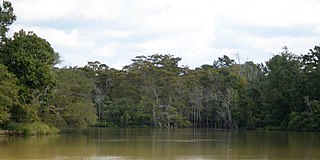
The Sabine River is a 360-mile (580 km) long river in the Southern U.S. states of Texas and Louisiana, From the 32nd parallel north and downstream, it serves as part of the boundary between the two states and empties into Sabine Lake, an estuary of the Gulf of Mexico.

Orange County is a county located in the very southeastern corner of the U.S. state of Texas, sharing a boundary with Louisiana, within the Golden Triangle of Texas. As of the 2020 census, its population was 84,808. The county seat is the city of Orange, and it falls within the Beaumont–Port Arthur metropolitan area.
The Neches River begins in Van Zandt County west of Rhine Lake and flows for 416 miles (669 km) through the piney woods of east Texas, defining the boundaries of 14 counties on its way to its mouth on Sabine Lake near the Rainbow Bridge. Two major reservoirs, Lake Palestine and B. A. Steinhagen Reservoir are located on the Neches. The Angelina River is a major tributary with its confluence at the north of Lake B. A. Steinhagen. Tributaries to the south include Village Creek and Pine Island Bayou, draining much of the Big Thicket region, both joining the Neches a few miles north of Beaumont. Towns and cities located along the river including Tyler, Lufkin, and Silsbee, although significant portions of the Neches River are undeveloped and flow through protected natural lands. In contrast, the lower 40 miles of the river are a major shipping channel, highly industrialized, with a number of cities and towns concentrated in the area including Beaumont, Vidor, Port Neches, Nederland, Groves, and Port Arthur.

Newton County is the easternmost county in the U.S. state of Texas. As of the 2020 census, its population was 12,217. Its county seat is Newton. The county is named for John Newton, a veteran of the American Revolutionary War.

Deweyville is a census-designated place (CDP) in Newton County, on the central eastern border of Texas, United States. The population was 571 at the 2020 census, down from 1,023 at the 2010 census.

Deweyville is a town in Box Elder County, Utah, United States. The population was 417 at the 2020 census, up from the 2010 figure of 332.

Toledo Bend Reservoir is a reservoir on the Sabine River between Texas and Louisiana. The lake has an area of 185,000 acres (750 km2), the largest man-made body of water partially in both Louisiana and Texas, the largest in the South, and the fifth largest by surface acre in the United States. The dam is capable of generating 92 megawatts of electrical power. The dam itself is located in the northeast corner of Newton County, Texas; however, that county includes very little of the reservoir, as most of it extends northward into parts of Sabine and DeSoto parishes in Louisiana, and Sabine, Shelby, and Panola counties in Texas.

Area code 409 is a telephone area code in the North American Numbering Plan (NANP) for the U.S. state of Texas. The numbering plan area comprises the Beaumont and Galveston areas. It was created on March 19, 1983, in an area code split of area code 713, the first since 619 split from 714 four months earlier. Initially, it consisted of a horseshoe-shaped area that almost completely surrounded Houston, but in 2000 it was divided into three sections. Area code 409 was retained by the eastern segment, while the central portion, centered on Nacogdoches, received area code 936 and the western portion centered on Bryan–College Station, was assigned area code .
Louisiana Highway 12 (LA 12) is a state highway located in southwestern Louisiana. It runs 34.64 miles (55.75 km) in an east–west direction from the Texas state line west of Starks to a junction with U.S. Highway 171 (US 171) and U.S. Highway 190 (US 190) in Ragley.
Texla is a ghost town in northern Orange County, Texas, United States, in the southeastern part of the state. It is located northwest of Orange, just west of Mauriceville. The site was originally called Bruce, after the postmaster Charles G. Bruce, who served when the office opened in 1905. The first sawmill to operate there was known as the Harrell-Votaw Lumber Company with proximity to the Orange and Northwestern Railway. The following year, the R. W. Wier Lumber Company out of Houston took over operations. The site was renamed Texla, due to its proximity to Louisiana. The owner Wier sold out to the Miller-Link Lumber Company in 1917. The peak population of the town reached an estimated 600 residents. In 1918 the mill was destroyed by fire, but was rebuilt in 1919 with a double-circular mill of the same size. Within a year, the Peavy-Moore Lumber Company of Deweyville took ownership, and operated the site until the nearby timber became exhausted. In 1929, the mill was dismantled and the site was abandoned.
From 1945 until 1977, a sawmill operated under the name Texla Lumber Company in nearby Mauriceville, according to the Texas Forestry Museum.
David Robert Wingate was an American lumber businessman and plantation farmer who served in the Confederate Army as the commissioner of defense for Jefferson County, Texas, during the American Civil War. Overcoming numerous financial setbacks throughout his lifetime, he remained a successful industrialist. He owned hundreds of slaves.
Burkeville is an unincorporated community in northern Newton County, Texas, United States. It sits at the intersection of State Highways 63 and 87, 10 miles west of the Sabine River. The Burkeville Independent School District serves the resident students.
Wild Cat Bluff is a ghost town in northwestern Anderson County, Texas, United States, and is a part of the Palestine, Texas micropolitan area.

Spur 69 is a 1.2-mile (1.9 km), unsigned, four-lane state highway spur in Austin, Texas, United States, that connects Ranch to Market Road 2222 (RM 2222) and Lamar Boulevard with Interstate 35 (I‑35) and U.S.Route 290 (US 290]]. It is part of Koenig Lane and is signed over its entire length as RM 2222, rather than as Spur 69.
Gaines Ferry was a ferry on the Sabine River, between what is now Sabine Parish, Louisiana and Sabine County, Texas, at the eastern terminus of Texas State Highway 21, and the western terminus of LA 6. Much of the early history of New Spain, France, Mexico, the Republic of Texas, the United States, including the American Civil War, and the U.S. states of Texas and Louisiana, involve some aspect of Gaines Ferry. It was a major highway to the west and cattle trail east, a port of entry for the Republic of Texas, and a transportation road for military supplies and soldiers during the American Civil War that included transporting cotton to Mexico. Gaines Ferry was the northern entry for many colonists heading to Texas, and it was named after James Gaines who purchased it in 1819. The ferry saw continuous service until 1937.
Belgrade is a ghost town in Newton County, in the U.S. state of Texas. Located near Farm to Market Road 1416 and one mile west of the Sabine River, Belgrade was a thriving community until the beginning of the Civil War. Now abandoned, a cemetery still remains, as well as a centennial marker. It was named after Belgrade, the capital of Serbia.
Halls Bluff or Hall's Bluff is a ghost town in Houston County, Texas, United States.

The Deweyville Swing Bridge, also known as Deweyville-Starks Swing Bridge and Sabine River Bridge, is a swing bridge which carries Texas State Highway 12 and Louisiana Highway 12 across the Sabine River at the Texas-Louisiana border. The bridge connects Deweyville, Texas to rural Calcasieu Parish, Louisiana, near the community of Starks. The Texas Highway Department and Louisiana Highway Commission built the bridge as a joint effort in 1936–38; the two highway departments used federal funding from Depression-era relief programs to complete the project. The bridge was one of four federally funded bridges between Texas and Louisiana built during the Great Depression. The swing bridge design, in which the center section of the bridge can rotate, allowed a variety of boats to pass by on the swift river. The bridge is the oldest surviving swing bridge of its design in Texas and one of three such bridges in the state.
Belzora is a ghost town located in Smith County, Texas, United States.
Dunagan is a ghost town in Angelina County, in the U.S. state of Texas. It is located within the Lufkin, Texas micropolitan area.
References
- ↑ Princeton, Texas: Handbook of Texas Online, University of Texas at Austin
Municipalities and communities of Newton County, Texas, United States | ||
|---|---|---|
| City |  | |
| CDPs | ||
| Other communities | ||
| Ghost towns | ||
| | This article about a location in Newton County, Texas is a stub. You can help Wikipedia by expanding it. |