Private place

Last updated
Gate at Washington Terrace, St. Louis, 1892 Washington terrace gate st. louis.jpg
Gate at Washington Terrace, St. Louis, 1892

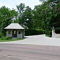
A private place is a self-governing enclave whose common areas (e.g. streets) are owned by the residents, and whose services are provided by the private sector.

Contents

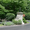
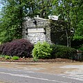
The history of St. Louis, Missouri, and its near suburbs is significant in the development of private places. Most were laid out by Prussian-born surveyor and planner Julius Pitzman, who conceived the idea around 1868 as a way for residential landowners to control real estate speculation and maintain property standards, in an era before the protections of zoning. Pitzman designed 47 of these developments over a 50-year period. [1]

The first of these, Lucas Place, dates from 1851 and no longer exists as such. But the growth of these developments began in earnest with Benton Place, in 1868, a 12-house development adjacent to Lafayette Square, St. Louis, and is in more-or-less original condition today. Vandeventer Place, opened in 1870 and included a house design by H.H. Richardson. Vandeventer Place has been replaced by urban development, with the exception of the east gate, which was removed to Forest Park.

In the 1920s, the idea was extended west into the county, particularly Ladue, by developers such as Meier and Comfort.

These privately controlled single-family housing communities in the midst of the city are legally organized somewhat similarly to condominiums, co-ops or homeowners associations. In 1982, the St. Louis metropolitan area had more than 427 street associations administering private places. [2] Although often associated with high-end communities, neighborhoods of various socio-economic natures have been structured as private places.

Private places in the City of St. Louis

Private places in St. Louis County

Related Research Articles

<span class="mw-page-title-main">Clayton, Missouri</span> City in Missouri, United States

Clayton is a city in and the seat of St. Louis County, Missouri. It borders the independent city of St. Louis. The population was 17,355 at the 2020 census. Organized in 1877, the city was named after Ralph Clayton, who donated the land for the St. Louis County courthouse.

<span class="mw-page-title-main">Missouri Route 141</span>

Route 141, also known as Woods Mill Road in parts of St. Louis County, is a state highway located in the western St. Louis metropolitan area. Its northern terminus is at Route 370 in Bridgeton; its southern terminus is at U.S. Route 61/U.S. Route 67 in Arnold, in Jefferson County. The northern stretches of the highway are often referred to as the Maryland Heights Expressway or Earth City Expressway.

<span class="mw-page-title-main">Greater St. Louis</span> Metropolitan area in the United States

Greater St. Louis is a bi-state metropolitan area that completely surrounds and includes the independent city of St. Louis, the principal city. It includes parts of both Missouri and Illinois. The city core is on the Mississippi Riverfront on the border with Illinois in the geographic center of the metro area. The Mississippi River bisects the metro area geographically between Illinois and Missouri; however, the Missouri portion is much more populous. St. Louis is the focus of the largest metro area in Missouri and the Illinois portion known as Metro East is the second largest metropolitan area in that state. St. Louis County is independent of the City of St. Louis and their two populations are generally tabulated separately.

<span class="mw-page-title-main">Protected view</span> Scenic views not allowed to be blocked

A protected view or protected vista is the legal requirement within urban planning to preserve the view of a specific place or historic building from another location. The effect of a protected view is to limit the height of new buildings within or adjacent to the sightline between the two places so as to preserve the ability to see the landmark as a focus of the view. The protection may also cover the area behind the place or building concerned.

Henry Wright, was a planner, architect, and major proponent of the garden city, an idea characterized by green belts and created by Sir Ebenezer Howard.

<span class="mw-page-title-main">Theodore Link</span> German-born American architect

Theodore C. Link, FAIA, was a German-born American architect and newspaper publisher. He designed buildings for the 1904 World's Fair, Louisiana State University, and the Mississippi State Capitol.

<span class="mw-page-title-main">Parkview, St. Louis</span> United States historic place

Parkview, also known as a "Saint Louis Urban Oasis," is a historic, private subdivision of St. Louis, Missouri. It is partly within the city limits of St. Louis and partly in University City. It is bounded by the Skinker-DeBaliviere neighborhood to the east, the Delmar Loop to the north, the Ames Place section of University City to the west, Washington University to the south, and Forest Park to the southeast.

<span class="mw-page-title-main">Compton Heights, St. Louis</span> Neighborhood of St. Louis in Missouri, United States

The Compton Heights historic neighborhood, located near the south side of St. Louis, Missouri in the shadow of the great water tower of Reservoir Park is one of the earliest planned residential developments of the American nineteenth century. Laid out in 1889 in accordance with a plan that viewed nature as a neighbor and not as an enemy to be subjugated by some rectilinear grid, its wide setbacks and curving streets create remarkable vistas, which are punctuated by more than 200 homes of extraordinary and varied interest. The entire neighborhood is a national historic district.

<span class="mw-page-title-main">Forest Park Southeast, St. Louis</span> Neighborhood of St. Louis in Missouri, United States

Forest Park Southeast (FPSE) is a neighborhood of St. Louis, Missouri. It is bordered by Interstate 64 to the north, Vandeventer Avenue to the east, Interstate 44 to the south, and Kingshighway Boulevard and Forest Park to the west. Adjoining neighborhoods include Kings Oak and The Hill to the west, Southwest Garden to the south, Botanical Heights to the southeast, Midtown to the east, and the Central West End to the north.

<span class="mw-page-title-main">Vandeventer, St. Louis</span> Neighborhood of St. Louis in Missouri, United States

Vandeventer is a neighborhood of St. Louis, Missouri. The area is bounded by Dr. Martin Luther King Drive on the North, Delmar Boulevard on the South, Vandeventer Avenue on the East, and Newstead Avenue on the West.

Julius Pitzman (1837–1923) was a Prussian-born American surveyor and city planner best known for his development of the private, gated neighborhoods in St. Louis, Missouri from 1867 through about 1914.

<span class="mw-page-title-main">Washington Terrace (St. Louis)</span> United States historic place

Washington Terrace is a residential private place in St. Louis, Missouri, laid out circa 1892. The gate is south of Union and Delmar, within the bounds of the Central West End.

<span class="mw-page-title-main">Architecture of St. Louis</span>

The architecture of St. Louis exhibits a variety of commercial, residential, and monumental architecture. St. Louis, Missouri is known for the Gateway Arch, the tallest monument constructed in the United States. Architectural influences reflected in the area include French Colonial, German, early American, European influenced, French Second Empire, Victorian, and modern architectural styles.

<span class="mw-page-title-main">Blue Line (St. Louis MetroLink)</span>

The Blue Line is the newer and shorter line of the MetroLink light rail service in St. Louis, Missouri, United States. It serves 25 stations across three counties and two states in Greater St. Louis.

<span class="mw-page-title-main">Kingsbury Place</span>

Kingsbury Place is a private place neighborhood in St. Louis, Missouri that was founded in 1902.

<span class="mw-page-title-main">Meier and Comfort</span>

Meier and Comfort was a real estate development firm active in the 1920s in the St. Louis suburbs of Clayton and Ladue, Missouri. The firm was the first to develop private place neighborhoods in Ladue, and their work was influential in establishing the architectural character of the city.

<span class="mw-page-title-main">Portland and Westmoreland Places</span> United States historic place

Portland and Westmoreland Places is a historic district in the Central West End neighborhood of St. Louis, Missouri. It is adjacent to the northeast corner of Forest Park. The district consists of 94 houses built circa 1890 to 1960. A wide variety of architectural styles are represented, including some of the finest examples of late nineteenth and early twentieth century architecture in the city.

<span class="mw-page-title-main">Brentmoor Park, Brentmoor and Forest Ridge District</span> United States historic place

The Brentmoor Park, Brentmoor and Forest Ridge District is a historic district comprising three private subdivisions in the city of Clayton, Missouri, a suburb of St. Louis, that were platted in 1910, 1911, and 1913, respectively by Henry Wright. It was listed on the National Register of Historic Places in 1982.

References

  1. David T. Beito, From Privies to Boulevards: The Private Supply of Infrastructure in the United States during the Nineteenth Century Archived 2011-07-20 at the Wayback Machine in Jerry Jenkins and David Sisk, eds., Development by Consent: The Voluntary Supply of Public Goods and Services, San Francisco: ICS Press, 1993, 2348; and The Formation of Urban Infrastructure through Non-Governmental Planning: The Private Places of St. Louis, 18691920, Journal of Urban History 16 (May 1990), 263301.
  2. Parks, Roger B. & Ronald J. Oakerson (1988), Metropolitan Organization: The St. Louis Case, Advisory Commission on Intergovernmental Relations, pp. 9, 84