
Charles Augustus Lindbergh was an American aviator, military officer, and author. On May 20–21, 1927, he made the first nonstop flight from New York to Paris, a distance of 3,600 miles (5,800 km), flying alone for 33.5 hours. His aircraft, the Spirit of St. Louis, was built to compete for the $25,000 Orteig Prize for the first flight between the two cities. Although not the first transatlantic flight, it was the longest at the time by nearly 2,000 miles (3,200 km), the first solo transatlantic flight, and set a new flight distance world record. The achievement garnered Lindbergh worldwide fame and stands as one of the most consequential flights in history, signalling a new era of air transportation between parts of the globe.
Seekonk is a town in Bristol County, Massachusetts, United States, on the Massachusetts border with Rhode Island. It was incorporated in 1812 from the western half of Rehoboth. The population was 15,531 at the 2020 census. In 1862, under a U.S. Supreme Court decision resolving a longstanding border dispute between Massachusetts and Rhode Island, a portion of Tiverton, Rhode Island was awarded to Massachusetts to become part of Fall River, while two-thirds of Seekonk was awarded to Rhode Island.

Roosevelt Field is a former airport, located in Westbury, Long Island, New York. Originally called the Hempstead Plains Aerodrome, or sometimes Hempstead Plains field or the Garden City Aerodrome, it was a training field for the Air Service, United States Army during World War I.

The Boston and Providence Railroad was a railroad company in the states of Massachusetts and Rhode Island which connected its namesake cities. It opened in two sections in 1834 and 1835 - one of the first rail lines in the United States - with a more direct route into Providence built in 1847. Branches were built to Dedham in 1834, Stoughton in 1845, and North Attleboro in 1871. It was acquired by the Old Colony Railroad in 1888, which in turn was leased by the New Haven Railroad in 1893. The line became the New Haven's primary mainline to Boston; it was realigned in Boston in 1899 during the construction of South Station, and in Pawtucket and Central Falls in 1916 for grade crossing elimination.
Overlook is a neighborhood in the North section of Portland, Oregon on the east shore of the Willamette River. It borders University Park and Arbor Lodge on the north, Humboldt and Boise on the east, Eliot on the southeast, and Northwest Industrial and the Northwest District across the Willamette on the west.

The East Junction Branch is a rail line in Rhode Island and Massachusetts, in the United States. Originally built by the Boston and Providence Railroad (B&P) in 1835, the line connects Attleboro, Massachusetts, and East Providence, Rhode Island via Seekonk, Massachusetts. As built, the line continued across the Seekonk River to Providence via the India Point Railroad Bridge; this connection was removed during the 1970s. The East Junction Branch meets the Northeast Corridor in Attleboro at a point known as East Junction, and ends at a connection to the East Providence Branch in East Providence. CSX Transportation operates freight service on the branch in Attleboro, while the Providence and Worcester Railroad (P&W) operates freight service in East Providence and across the state line into Seekonk. The line is owned by the P&W in Rhode Island, and by the Massachusetts Bay Transportation Authority in Massachusetts.

Sharpe Field is a closed private use airport located six nautical miles northwest of the central business district of Tuskegee, a city in Macon County, Alabama, United States. This airport is privately owned by the Bradbury Family Partnership.
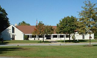
Seekonk High School is a public high school operated by Seekonk Public Schools in Seekonk, Massachusetts, United States. It serves the district's grade 9–12 student population. The school's mission statement is "All students will achieve their maximum potential by becoming responsible, productive citizens and life-long learners."
Moore Army Airfield is a former airfield located in Fort Devens, Massachusetts. It was closed following the closure of the fort in 1995. It is named for Ayer native Chief Warrant Officer 2 Douglas Moore. It was the only Army Airfield named for someone killed in the Vietnam War. It is currently used for racing and State Police driver training.

Imeson Field, also known as Jacksonville Imeson Airport, was the airport serving Jacksonville, Florida, from 1927 until its closing in 1968. It was known as Jacksonville Municipal Airport prior to World War II, Jacksonville Army Airfield when the United States Army Air Forces controlled the facility during World War II, and at its closing the airport was Jacksonville – Thomas Cole Imeson Municipal Airport.

Grand Central Airport is a former airport in Glendale, California. Also known as Grand Central Air Terminal (GCAT), the airport was an important facility for the growing Los Angeles suburb of Glendale in the 1920s and a key element in the development of United States aviation. The terminal, located at 1310 Air Way, was built in 1928 and still exists, owned since 1997 by The Walt Disney Company as a part of its Grand Central Creative Campus (GC3). Three hangars also remain standing. The location of the single concrete 3,800-foot (1,200 m) runway has been preserved, but is now a public street as the runway was dug up and converted into Grand Central Avenue.

Fairfax Municipal Airport was a Kansas City, Kansas airfield from 1921 that was used during 1935–1949 by the military. Federal land adjacent to the airfield included a WWII B-25 Mitchell plant and modification center and a Military Air Transport terminal. After being used as a Cold War-era Air Force Base, it was used for airliner servicing by TWA and for automobile and jet fighter aircraft production by General Motors, which built a 1985 Fairfax Plant over runways when the municipal airport closed.
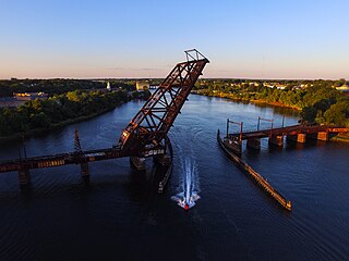
The Crook Point Bascule Bridge is a defunct Scherzer rolling lift railway bridge which spans the Seekonk River, connecting the city of Providence, Rhode Island, to the city of East Providence. Stuck in the open position since its abandonment in 1976, it is known to nearby residents as the "Stuck-Up Bridge" and has become somewhat of a local icon of urban decay. In 2022, the Providence Journal described the bridge as "a T-shirt-ready symbol of Providence's quirky evolution from industrial to creative hub."

The Providence, Warren and Bristol Railroad was a railroad in the state of Rhode Island that connected the city of Providence with Bristol, Rhode Island. The company was formed in 1854 by merging the Providence, Warren and Bristol Railroad Companies of Massachusetts and Rhode Island. The 14.1-mile line itself was completed on July 12, 1855.

Haren Airport or Evere Airfield is a former military airfield and civil airport in Brussels, Belgium. Located in Brussels' city section of Haren and adjacent municipality of Evere, it was established by the German Empire in 1914 and lasted until the early 1950s when it was closed. Meanwhile it had been replaced by nearby Melsbroek airfield that Nazi Germany had established in World War II, which developed into the current Brussels Airport. The former grounds of Haren-Evere airfield were redeveloped as part of the expanding Brussels urban area; some buildings remain in use as facilities of the Belgian military. Since 2017, NATO headquarters are located at Haren (Brussels) on part of the former airport grounds.
Bowles Agawam Airport was an airfield operational in the mid-20th century in Agawam, Massachusetts.
Vail Airport, Montebello was an airport in Montebello, California from 1926 to 1953. The airport was owned and operated by Western Air Express. Western Air Express purchased 700 acres of Vail farm to build the private airport from the Vail brothers. The vast airport was boarded by Telegraph Road on the south, Ferguson Drive on the north, Tusbway Avenue on the west, and Yates Avenue to the east. A group of Los Angeles entrepreneurs founded Western Air Express and the airport to cash in on the Air Mail Act of 1925 that opened up bidding on air mail contracts. Western Air Express purchased six Douglas mailplanes model M-2 to start the company. Western Air Express built two 2 unpaved runways running north–south in the middle of the lot, along the current Yates Avenue. A nearby movie studio building was turned into the main hangar and three more were built. Western Air Express won an airmail contract run from Las Vegas to Salt Lake City in 1926. In 1927 the local airport became famous as Charles Lindbergh landed The Spirit of St. Louis at the airport on a nationwide. Leland A. Bryant designed and built his racing aircraft at Vail Airport starting in 1927. Ryan Mechanics built the Lone Eagle CM-1 at Vail Airport in 1928.

Peik Auxiliary Field also called Peik Field and Peik Airport was an airfield used during World War II to support the San Bernardino Army Air Field, Desert Training Center and San Diego Municipal Airport, called Lindbergh Field. The local Peik Airport was built in 1934 by Arnold Peik, his son Leander Peik (1927-2011) and his family, barnstormers from Wisconsin, that also ran a flight school at the airport. Leander Peik dad taught him to fly when he was 10 years old, he became the airport manager at a young age. With the start of World War II there was a demand for trained pilots and the Army took over the Airport. Auxiliary fields, like Peik, were used to support the training of US Army pilots during World War II. The runway was located in Mission Bay of San Diego, California. The runways as in the southeast corner of Mission Bay, near the current Interstate 5 and Interstate 8 interchange. The entrance to the Peik Auxiliary Field was at the end of Anna Avenue, which at the time extended into Mission Bay. When the I-5 was built Anna Avenue was removed west of the Santa Fe train tracks. For the war, many new trained pilots were needed. Peik Auxiliary Field provided a place for pilots to practice landing and take off without other air traffic. Peik Auxiliary Field site offered flight training without distractions. The United States Army Air Corps's Army Air Forces Basic Flying School, the Army Air Force Pilot School used Peik Auxiliary Field for fighter pilots training. The Army took the runway from 800-feet to 2,600-feet long and 150-feet wide made of turfgrass. To support the training of the many pilots, San Bernardino Army Air Field operated a number of auxiliary airfields. After the war, Peik Auxiliary Field was returned to the Peik family. The Peik family closed the airport in 1955 and no trace of the runway can be found today, the site is open land in Mission Bay with Sea World Drive cutting across the past runway.

Columbia Field, originally Curtiss Field, is a former airfield near Valley Stream within the Town of Hempstead on Long Island, New York. Between 1929 and 1933 it was a public airfield named Curtiss Field after the Curtiss-Wright aircraft corporation that owned it. The public airfield closed after 1933, but aircraft continued to be manufactured there primarily by Columbia Aircraft Corporation, which gave the private airfield its name.
