Penang is a Malaysian state located on the northwest coast of Peninsular Malaysia, by the Malacca Strait. It has two parts: Penang Island, where the capital city, George Town, is located, and Seberang Perai on the Malay Peninsula. They are connected by Malaysia's two longest road bridges, the Penang Bridge and the Sultan Abdul Halim Muadzam Shah Bridge; the latter is also as of May 2019 the longest oversea bridge in Southeast Asia. The second smallest Malaysian state by land mass, Penang is bordered by Kedah to the north and the east, and Perak to the south.

Jurong is a geographical region located at the south-westernmost point of the West Region of Singapore. Although mostly vaguely defined, the region's extent roughly covers the planning areas of Jurong East, Jurong West, Boon Lay, and Pioneer, along with Jurong Island in the Western Islands cluster and the southernmost portions of the Western Water Catchment. Should it be described at its greatest historical extent, the region can also include present-day Bukit Batok and Tuas as well. Jurong also covers several offshore islands as well, including Pulau Damar Laut and Pulau Samulun, both of which are located within the planning areas of Jurong East and Boon Lay respectively; along with the aforementioned Jurong Island. The coastline of the region on mainland Singapore, faces the strait of Selat Jurong, while the southernmost island of the region, Jurong Island, faces the strait of Selat Pandan.

Pulau Tekong, also known colloquially as Tekong, is the second-largest of Singapore's outlying islands, with an area of 24.43 km2. The island is still expanding due to land reclamation works on its southern and northwestern coasts which will eventually subsume many of its surrounding small islets, including the 89-hectare (220-acre) Pulau Tekong Kechil. Transport to the island is by SAF Changi Ferry Terminal.

Pulau Ubin, also simply known as Ubin, is an island situated in the north east of Singapore, to the west of Pulau Tekong. The Granite quarry used to be supported by a few thousand settlers on Pulau Ubin in the 1960s, but only about 38 villagers remains as of 2012. It is one of the last rural areas to be found in Singapore, with an abundance of natural flora and fauna. The island forms part of the Ubin–Khatib Important Bird Area (IBA), identified as such by BirdLife International because it supports significant numbers of visiting and resident birds, some of which are threatened. Today, the island is managed by the National Parks Board, compared to 12 agencies managing different areas of the island previously.

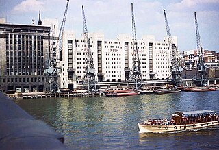
The Port of Singapore refers to the collective facilities and terminals that conduct maritime trade, and which handle Singapore's harbours and shipping. It is ranked as the top maritime capital of the world since 2015. Currently the world's second-busiest port in terms of total shipping tonnage, it also trans-ships a fifth of the world's shipping containers, half of the world's annual supply of crude oil, and is the world's busiest transshipment port. It was also the busiest port in terms of total cargo tonnage handled until 2005 when it was surpassed by the Port of Shanghai. Thousands of ships drop anchor in the harbour, connecting the port to over 600 other ports in 123 countries and spread over six continents.

Pulau Brani is an island located off the southern coast of Singapore, near Keppel Harbour. The island is situated between the main island of Singapore and the resort island of Sentosa, and is linked to the mainland via Brani Terminal Avenue. The area of Pulau Brani is 1.22 square kilometres.

The Singapore River is a river that runs parallel to Alexandra Road and feeds into the Marina Reservoir in the southern part of Singapore. The immediate upper watershed of the Singapore River is known as the Singapore River Planning Area, although the western part of the watershed is classified under River Valley planning area.

Raffles Place is the centre of the Financial District of Singapore and is located south of the mouth of the Singapore River. It was first planned and developed in the 1820s as Commercial Square to serve as the hub of the commercial zone of Singapore in Raffles Town Plan. It was renamed Raffles Place in 1858 and is now the site of a number of major banks. It is located in the Downtown Core within the Central Area, and features some of the tallest buildings and landmarks of the country.

Pulau Semakau is located to the south of the main island of Singapore, off the Straits of Singapore. The Semakau Landfill is located on the eastern side of the island, and was created by the amalgamation of Pulau Sakeng, and "anchored" to Pulau Semakau. The Semakau Landfill is Singapore's first offshore landfill and now the only remaining landfill in Singapore.

Bryher is one of the smaller of the inhabited islands of the Isles of Scilly.

Perai is an urban settlement in the city of Seberang Perai, Penang, Malaysia. It lies at the southern bank of the Perai River and borders Butterworth to the north. Perai gave its name to the city of Seberang Perai, the mainland half of the State of Penang.
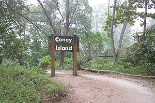
Coney Island, alternatively known as Pulau Serangoon, is a 133-hectare island located off the northeastern coast of Singapore within the town of Punggol, between Pulau Ubin to its northeast and the mainland to its southwest.

Ord Bridge is a pedestrian bridge in Singapore. It spans the Singapore River at Clarke Quay, located in the Singapore River Planning Area within the Central Area.
Pulau Senang is an 81.7-hectare coral-formed island in the Republic of Singapore, located about 13 kilometres off the southern coast of the main island of Singapore. Along with Pulau Pawai to the northwest and Pulau Sudong further behind Pulau Pawai, it is used as a military training area for live-fire exercises carried out by the Singapore Armed Forces (SAF). Pulau Senang is best known in the history of Singapore as the location of a former experimental offshore penal settlement that failed after only three years when an infamous riot against the small unit of prison authority broke out in 1963, resulting in the death of three officers, including the overall prison-chief.
The North-Eastern Islands is a planning area and a group of islands located within the North-East Region of Singapore. The cluster is made up of three islands, namely Pulau Tekong, Pulau Tekong Kechil and Pulau Ubin. Pulau Tekong and Pulau Tekong Kechil were formerly home to 10 villages while Pulau Ubin was home to a number of granite quarries. At present, Pulau Tekong houses the Singapore Armed Forces Basic Military Training Centre while Pulau Ubin is one of the last areas in Singapore that has been preserved from urban development, concrete buildings and tarmac roads.

Serangoon Harbour is a harbour in Singapore located between the mainland island of Singapore and Pulau Ubin.

The River Tillingham flows through the English county of East Sussex. It meets the River Brede and the eastern River Rother near the town of Rye. A navigable sluice controlled the entrance to the river between 1786 and 1928, when it was replaced by a vertical lifting gate which was not navigable. The river provided water power to operate the bellows of an iron works at Beckley Furnace, used to make cannons for the Royal Navy between 1578 and 1770, when it became uneconomic, and a water mill which replaced it, until that burnt down in 1909. The lower reaches supported a thriving shipbuilding industry from the early nineteenth century onwards, and although on a smaller scale, was still doing so in 2000.

The Thousand Islands are a chain of islands to the north of Jakarta's coast. It forms the only regency of Jakarta, the capital of Indonesia. It consists of a string of 342 islands stretching 45 km (28 mi) north into the Java Sea at West Jakarta Bay and in fact north of Banten Province.
Fresh Wharf was a wharf located in the City of London close to London Bridge, on the north bank of the River Thames. The site was used as a quay in Roman times and later as an unloading place for Anglo-Saxon boats. A wharf was constructed there at some point in the medieval period and appears to have acquired its name from its customary usage as a landing place for fresh fish. In the 16th century, Fresh Wharf was made a "Legal Quay" authorised for the import of certain goods during the reign of Queen Elizabeth I of England. It expanded as London's river-borne trade grew in the 18th and 19th centuries, with large warehouses being established immediately behind the wharf. In the 20th century, the wharf's owners took over the adjoining wharves immediately upstream and downstream, built a new ten-storey warehouse and renamed the site New Fresh Wharf. By the end of the 1960s, however, London's docks had fallen into disuse with the advent of containerization, for which they were not suited, and the wharf was closed down in 1970. An office block was built on the site of the warehouse in 1977 and the former quayside is now part of a public footpath along the Thames.
Pulau Seletar is an island situated in the Straits of Johor off the northern coast of Singapore. Located within Singapore waters, it has an area of 38.5 hectare. It lies within a bay into which several streams flow, including the waters of mainland Singapore's only hot spring.
