
Jurong Island is an island located to the southwest of the main island of Singapore. It was formed from the amalgamation of seven offshore islands, the islands of Pulau Ayer Chawan, Pulau Ayer Merbau, Pulau Merlimau, Pulau Pesek, Pulau Pesek Kechil, Pulau Sakra, Pulau Seraya, Pulau Meskol, Pulau Mesemut Laut, Pulau Mesemut Darat and Anak Pulau. This was done through Singapore's land reclamation efforts. Land reclamation on Jurong Island was completed on 25 September 2009, 20 years earlier than scheduled. Pulau Buaya was joined to Jurong Island via reclamation in 2010. Jurong Island forms a land area of about 32 km2 (12 sq mi) from an initial area of less than 10 km2 (4 sq mi), and is the largest of Singapore's outlying islands.

Pulau Tekong, also known colloquially as Tekong or Tekong Island, is the second-largest of Singapore's outlying islands after Jurong Island. Tekong is located off Singapore's northeastern coast, east of Pulau Ubin. Since the 1990s, the island has been used by the Singapore Armed Forces (SAF) and is generally restricted from public access. Transport to the island for permitted persons is via the SAF Changi Ferry Terminal at Changi Beach.

Pulau Ubin, also simply known as Ubin, is an island situated in the north east of Singapore, to the west of Pulau Tekong. The granite quarry used to be supported by a few thousand settlers on Pulau Ubin in the 1960s, but only about 40 villagers remained as of 2012. It is one of the last rural areas to be found in Singapore, with an abundance of natural flora and fauna. The island forms part of the Ubin–Khatib Important Bird Area (IBA), identified as such by BirdLife International because it supports significant numbers of visiting and resident birds, some of which are threatened. Today, the island is managed by the National Parks Board, compared to 12 agencies managing different areas of the island previously.

Pedra Branca is an outlying island and the easternmost point of Singapore. The name of the island, which is Portuguese for "white rock", refers to whitish guano deposited on the rock. The island consists of a small outcrop of granite rocks with an area of about 8,560 square metres (92,100 sq ft) at low tide. During the low water spring tide it measures, at its longest, 137 metres (449 ft) and has an average width of 60 metres (200 ft). Pedra Branca is situated at 1°19′48″N104°24′27″E, where the Singapore Strait meets the South China Sea.
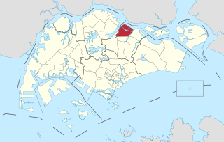
Seletar is an area located in the north-east of Singapore. Its name can also refer to the Seletar Planning Area, situated in the North-East Region of Singapore. The place name was derived from the Malay subgroup who were indigenous to the area, the Orang Seletar. It shares boundaries with the planning areas of Sengkang to the south, Punggol to the east, Yishun and Simpang to the west, as well as the Straits of Johor to the north.

Sisters' Islands are two of the Southern Islands in Singapore and are located to the south of the main island of Singapore, off the Straits of Singapore. It can be reached via a boat ride from Marina South Pier or West Coast Pier.
Pulau Hantu is located to the south of the main island of Singapore, off the Straits of Singapore. Pulau Hantu is actually made up of two islets: Pulau Hantu Besar and Pulau Hantu Kechil, with a total area of 12.6 hectares. At low tide, it is possible to wade across the shallow lagoon between the two islands, but not at high tide.

The Tampines Expressway (TPE) is a highway in the north-eastern fringe of Singapore, joining the Pan Island Expressway (PIE) near Singapore Changi Airport in the east with the Central Expressway (CTE) and Seletar Expressway (SLE) in the north of the island.

Redang Island is an island in Kuala Nerus District, Terengganu, Malaysia. It is one of the largest islands off the east coast of Peninsular Malaysia and one of the most beautiful islands in the world. It is famous for its crystal clear waters and white sandy beaches. It is one of nine islands, which form a marine sanctuary park offering snorkeling and diving opportunities for tourists.
Pulau Semakau is located to the south of the main island of Singapore, off the Straits of Singapore. The Semakau Landfill is located on the eastern side of the island, and was created by the amalgamation of Pulau Sakeng, and "anchored" to Pulau Semakau. The Semakau Landfill is Singapore's first offshore landfill and now the only remaining landfill in Singapore.

The North-East Region of Singapore is one of the five regions in the country. The region is the most densely populated and has the highest population among the five, with Sengkang being its most populous town as of 2020 and Seletar as the regional centre. Comprising 13,810 hectares, it includes seven planning areas and is largely a residential region with 217,120 homes. Housing largely consists of high-density HDB public housing estates, however private housing is also present in the region. As its name implies, it is located in the north-eastern part of Singapore.
Singapore has about 65 species of mammals, 390 species of birds, 110 species of reptiles, 30 species of amphibians, more than 300 butterfly species, 127 dragonfly species, and over 2,000 recorded species of marine wildlife.

Serangoon Harbour is a harbour in Singapore located between the mainland island of Singapore and Pulau Ubin.
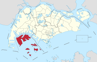
The Western Islands is a planning area located within the West Region of Singapore. It comprises a collection of islands located in the south-western waters of Singapore, namely Jurong Island, Pulau Bukom and Sudong Islands.
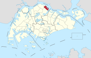
Simpang, is a planning area located in the North Region of Singapore. The word Simpang means junction or intersection in Malay. It is situated north of Yishun, east of Sembawang and west of Seletar. Pulau Seletar is classified under Simpang planning area. Jalan Kuala Simpang was the main road serving the area. Sungei Simpang Kiri, Sungei Simpang Kanan and Simpang Kiri Park Connector retain and reflect the name of the area.

Orang Seletar are one of the 18 Orang Asli ethnic groups in Malaysia. They are classified under the Proto-Malay people group, which forms the three major people group of the Orang Asli. The Orang Seletar are also considered as part of the Orang Laut, natives of the Straits of Johor; separating Singapore from Peninsula Malaysia.
Pulau Sarimbun is a small island situated in the Straits of Johor, off the north-western coast of Singapore. Located within Singapore waters, it has an area of 1.4 hectares.
Sungei Simpang Kiri is a river located in eastern part of Sembawang, Singapore. The river starts near Canberra Link and discharges into the Straits of Johor.
Rural East Constituency was a constituency represented in the Legislative Council of Singapore from 1948 until 1951. It elected one Legislative Council member.
