Middletown is a town in Newport County, Rhode Island, United States. The population was 17,075 at the 2020 census. It lies to the south of Portsmouth and to the north of Newport on Aquidneck Island, hence the name "Middletown."

The lithology of a rock unit is a description of its physical characteristics visible at outcrop, in hand or core samples, or with low magnification microscopy. Physical characteristics include colour, texture, grain size, and composition. Lithology may refer to either a detailed description of these characteristics, or a summary of the gross physical character of a rock. Examples of lithologies in the second sense include sandstone, slate, basalt, or limestone.

The Los Angeles Basin is a sedimentary basin located in Southern California, in a region known as the Peninsular Ranges. The basin is also connected to an anomalous group of east-west trending chains of mountains collectively known as the Transverse Ranges. The present basin is a coastal lowland area, whose floor is marked by elongate low ridges and groups of hills that is located on the edge of the Pacific Plate. The Los Angeles Basin, along with the Santa Barbara Channel, the Ventura Basin, the San Fernando Valley, and the San Gabriel Basin, lies within the greater Southern California region. The majority of the jurisdictional land area of the city of Los Angeles physically lies within this basin.

The Narryer Gneiss Terrane is a geological complex in Western Australia that is composed of a tectonically interleaved and polydeformed mixture of granite, mafic intrusions and metasedimentary rocks in excess of 3.3 billion years old, with the majority of the Narryer Gneiss Terrane in excess of 3.6 billion years old. The rocks have experienced multiple metamorphic events at amphibolite or granulite conditions, resulting in often complete destruction of original igneous or sedimentary (protolith) textures. Importantly, it contains the oldest known samples of the Earth's crust: samples of zircon from the Jack Hills portion of the Narryer Gneiss have been radiometrically dated at 4.4 billion years old, although the majority of zircon crystals are about 3.6-3.8 billion years old.
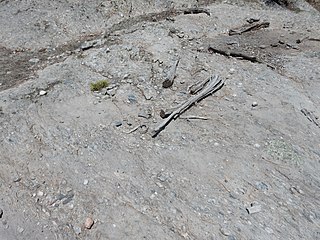
Lineations in structural geology are linear structural features within rocks. There are several types of lineations, intersection lineations, crenulation lineations, mineral lineations and stretching lineations being the most common. Lineation field measurements are recorded as map lines with a plunge angle and azimuth.

The Roxbury Conglomerate, also informally known as Roxbury puddingstone, is a name for a rock formation that forms the bedrock underlying most of Roxbury, Massachusetts, now part of the city of Boston. The bedrock formation extends well beyond the limits of Roxbury, underlying part or all of Quincy, Canton, Milton, Dorchester, Dedham, Jamaica Plain, Brighton, Brookline, Newton, Needham, and Dover. It is named for exposures in Roxbury, Boston area. It is the Rock of the Commonwealth in Massachusetts.

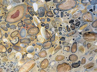
Puddingstone, also known as either pudding stone or plum-pudding stone, is a popular name applied to a conglomerate that consists of distinctly rounded pebbles whose colours contrast sharply with the colour of the finer-grained, often sandy, matrix or cement surrounding them. The rounded pebbles and the sharp contrast in colour gives this type of conglomerate the appearance of a raisin or Christmas pudding. There are different types of puddingstone, with different composition, origin, and geographical distribution. Examples of different types of puddingstones include the Hertfordshire, Schunemunk, Roxbury, and St. Joseph Island puddingstones.

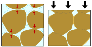
In structural geology and diagenesis, pressure solution or pressure dissolution is a deformation mechanism that involves the dissolution of minerals at grain-to-grain contacts into an aqueous pore fluid in areas of relatively high stress and either deposition in regions of relatively low stress within the same rock or their complete removal from the rock within the fluid. It is an example of diffusive mass transfer.

The geology of Massachusetts includes numerous units of volcanic, intrusive igneous, metamorphic and sedimentary rocks formed within the last 1.2 billion years. The oldest formations are gneiss rocks in the Berkshires, which were metamorphosed from older rocks during the Proterozoic Grenville orogeny as the proto-North American continent Laurentia collided against proto-South America. Throughout the Paleozoic, overlapping the rapid diversification of multi-cellular life, a series of six island arcs collided with the Laurentian continental margin. Also termed continental terranes, these sections of continental rock typically formed offshore or onshore of the proto-African continent Gondwana and in many cases had experienced volcanic events and faulting before joining the Laurentian continent. These sequential collisions metamorphosed new rocks from sediments, created uplands and faults and resulted in widespread volcanic activity. Simultaneously, the collisions raised the Appalachian Mountains to the height of the current day Himalayas.

The island of Taiwan was formed approximately 4 to 5 million years ago at a convergent boundary between the Philippine Sea Plate and the Eurasian Plate. In a boundary running the length of the island and continuing southwards, the Eurasian Plate is sliding under the Philippine Sea Plate. In the northeast of the island, the Philippine Sea Plate slides under the Eurasian Plate. Most of the island comprises a huge fault block tilted to the west.

The Sherwood Sandstone Group is a Triassic lithostratigraphic group which is widespread in Britain, especially in the English Midlands. The name is derived from Sherwood Forest in Nottinghamshire which is underlain by rocks of this age. It has economic importance as the reservoir of the Morecambe Bay gas field, the second largest gas field in the UK.

Link is a rock outcrop on the surface of Aeolis Palus, between Peace Vallis and Aeolis Mons, in Gale crater on the planet Mars. The outcrop was encountered by the Curiosity rover on the way from Bradbury Landing to Glenelg Intrigue on September 2, 2012, and was named after a significant rock formation in the Northwest Territories of Canada. The "approximate" site coordinates are: 4.59°S 137.44°E.

The Catoctin Formation is a geologic formation that expands through Virginia, Maryland, and Pennsylvania. It dates back to the Precambrian and is closely associated with the Harpers Formation, Weverton Formation, and the Loudoun Formation. The Catoctin Formation lies over a granitic basement rock and below the Chilhowee Group making it only exposed on the outer parts of the Blue Ridge. The Catoctin Formation contains metabasalt, metarhyolite, and porphyritic rocks, columnar jointing, low-dipping primary joints, amygdules, sedimentary dikes, and flow breccias. Evidence for past volcanic activity includes columnar basalts and greenstone dikes.

The geology of Rhode Island is based on nearly one billion year old igneous crystalline basement rocks formed as part of the microcontinent Avalonia that collided with the supercontinent Gondwana. The region experienced substantial folding associated with its landlocked position during the Alleghanian orogeny mountain building event. The region accumulated sedimentary rocks, including small deposits of coal. The region was covered with thick Atlantic Coastal Plain sediments, with the erosion of the Appalachians and the creation of the Atlantic Ocean throughout the past 200 million years. These surficial sediments and soils were substantially reworked by the Pleistocene glaciations. The state's geology is part of the broader geology of New England.

The geology of Guam formed as a result of mafic, felsic and intermediate composition volcanic rocks erupting below the ocean, building up the base of the island in the Eocene, between 33.9 and 56 million years ago. The island emerged above the water in the Eocene, although the volcanic crater collapsed. A second volcanic crater formed on the south of the island in the Oligocene and Miocene. In the shallow water, numerous limestone formations took shape, with thick alternating layers of volcanic material. The second crater collapsed and Guam went through a period in which it was almost entirely submerged, resembling a swampy atoll, until structural deformation slowly uplifted different parts of the island to their present topography. The process of uplift led to widespread erosion and clay formation, as well as the deposition of different types of limestone, reflecting different water depths.
The geology of the U.S. Virgin Islands includes mafic volcanic rocks, with complex mineralogy that first began to erupt in the Mesozoic overlain and interspersed with carbonate and conglomerate units.

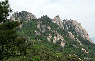
The geology of South Korea includes rocks dating to the Archean and two large massifs of metamorphic rock as the crystalline basement, overlain by thick sedimentary sequences, younger metamorphic rocks and volcanic deposits. Despite the country's small size, its geology is diverse, containing rocks formed during the Precambrian to Cenozoic eras.
The geology of El Salvador is underlain by rocks dating to the Paleozoic. Prior to the Pennsylvanian, sediments deposited and were intensely deformed, intruded by granite rocks and metamorphosed. Northern Central America took shape during uplift in the Triassic, large than its current area and extending east to the Nicaragua Rise. The Cayman Ridge and Bartlet Trough formed from longitudinal faults at the crest of the uplift. Deformation in the Cretaceous brought granite intrusions, particularly in what is now Nicaragua. Much of the terrain and coastline of the country is defined by volcanoes and volcanic deposits produced from the subduction of the Cocos Plate.

The Big Rock Formation is a formation that crops out in the Tusas Mountains of northern New Mexico. Detrital zircon geochronology gives a maximum age for the formation of 1665 Mya, corresponding to the Statherian period.

The geology of the Ellsworth Mountains, Antarctica, is a rock record of continuous deposition that occurred from the Cambrian to the Permian periods, with basic igneous volcanism and uplift occurring during the Middle to Late Cambrian epochs, deformation occurring in the Late Permian period or early Mesozoic era, and glacier formation occurring in the Cretaceous period and Cenozoic era. The Ellsworth Mountains are located within West Antarctica at 79°S, 85°W. In general, it is made up of mostly rugged and angular peaks such as the Vinson Massif, the highest mountain in Antarctica.


