Putnam, Oklahoma

Last updated

Putnam, Oklahoma
OKMap-doton-Putnam.PNG
Location of Putnam, Oklahoma
Coordinates: 35°51′21″N98°58′06″W / 35.85583°N 98.96833°W / 35.85583; -98.96833
Country United States
State Oklahoma
County Dewey
Area
[1]
  Total0.09 sq mi (0.22 km2)
  Land0.09 sq mi (0.22 km2)
  Water0.00 sq mi (0.00 km2)
Elevation
[2]
1,965 ft (599 m)
Population
 (2020)
  Total30
  Density352.94/sq mi (136.71/km2)
Time zone UTC-6 (Central (CST))
  Summer (DST) UTC-5 (CDT)
ZIP code
73659
Area code 580
FIPS code 40-61250 [3]
GNIS feature ID2412512 [2]

Putnam is a town in Dewey County, Oklahoma, United States. The population was 30 as of the 2020 United States census. [4] The community lies along U.S. Route 183.

Contents

Geography

Putnam is located in southern Dewey County. Via US 183 it is 13 miles (21 km) north to Taloga, the county seat, and 22 miles (35 km) to Seiling. To the south on 183, it is 23 miles (37 km) to Clinton.

According to the United States Census Bureau, Putnam has a total area of 0.10 square miles (0.26 km2), all land. [5]

Demographics

Historical population
CensusPop.Note
1930 140
1940 1421.4%
1950 106−25.4%
1960 83−21.7%
1970 841.2%
1980 74−11.9%
1990 44−40.5%
2000 464.5%
2010 29−37.0%
2020 303.4%
U.S. Decennial Census [6]

As of the census [3] of 2000, there were 46 people, 20 households, and 16 families residing in the town. The population density was 455.1 inhabitants per square mile (175.7/km2). There were 30 housing units at an average density of 296.8 per square mile (114.6/km2). The racial makeup of the town was 97.83% White and 2.17% Native American. Hispanic or Latino of any race were 2.17% of the population.

There were 20 households, out of which 35.0% had children under the age of 18 living with them, 70.0% were married couples living together, 10.0% had a female householder with no husband present, and 20.0% were non-families. 20.0% of all households were made up of individuals, and 10.0% had someone living alone who was 65 years of age or older. The average household size was 2.30 and the average family size was 2.56.

In the town, the population was spread out, with 21.7% under the age of 18, 28.3% from 25 to 44, 34.8% from 45 to 64, and 15.2% who were 65 years of age or older. The median age was 44 years. For every 100 females, there were 130.0 males. For every 100 females age 18 and over, there were 125.0 males.

The median income for a household in the town was $40,417, and the median income for a family was $42,083. Males had a median income of $16,875 versus $15,625 for females. The per capita income for the town was $17,928. There were no families and 3.4% of the population living below the poverty line, including no under eighteens and none of those over 64.

Related Research Articles

<span class="mw-page-title-main">Dewey County, Oklahoma</span> County in Oklahoma, United States

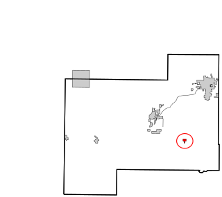
Dewey County is a county in the western part of the U.S. state of Oklahoma. As of the 2020 census, the population was 4,484. Its county seat is Taloga. The county was created in 1891 as "County D". In an 1898 election, county voters chose the name Dewey, honoring Admiral George Dewey.

<span class="mw-page-title-main">Fillmore, Indiana</span> Town in Indiana, United States

Fillmore is a town in Marion Township, Putnam County, in the U.S. state of Indiana. The population was 532 at the 2020 census.

<span class="mw-page-title-main">Carter, Oklahoma</span> Town in Oklahoma, United States

Carter is a town in Beckham County, Oklahoma, United States. The population was 183 at the time of the 2020 census.

<span class="mw-page-title-main">Butler, Oklahoma</span> Town in Oklahoma, United States

Butler is a town in Custer County, Oklahoma, United States. The population was 208 at the time of the 2020 census, down from 287 at the 2010 census.

<span class="mw-page-title-main">Camargo, Oklahoma</span> City in Oklahoma, United States

Camargo is a town in Dewey County, Oklahoma, United States. The population was 193 as of the 2020 United States census, an increase over the 178 reported at the 2010 census, and the figure of 115 reported in 2000.

<span class="mw-page-title-main">Leedey, Oklahoma</span> Town in Oklahoma, United States

Leedey is a town in Dewey County, Oklahoma, United States. The population was 415 at the 2020 census.

<span class="mw-page-title-main">Oakwood, Oklahoma</span> Town in Oklahoma, United States

Oakwood is a town in Dewey County, Oklahoma, United States. The population was 74 as of the 2020 United States census, an increase of about 13.8% from the population of 65 reported by the 2010 census.

<span class="mw-page-title-main">Seiling, Oklahoma</span> City in Oklahoma, United States

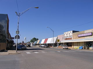
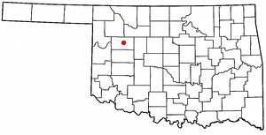
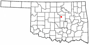
Seiling is a city in Dewey County, Oklahoma, United States. The population was 850 at the 2020 census. The town was named in 1899 for Louis Seiling, a local store owner who had acquired a homestead in the Cheyenne-Arapaho land run of April 1892. The Hobson Town and Improvement Company established a town called Hobson, but the name was changed to Seiling in January 1899. It incorporated in 1909. Seiling is now the largest city in Dewey County. Their girls basketball team has also won the Oklahoma State Championship four times in a row (2016-2019).

<span class="mw-page-title-main">Taloga, Oklahoma</span> Town in Oklahoma, United States

Taloga is a town in Dewey County, Oklahoma, United States. The population was 288 at the time of the 2020 census.

<span class="mw-page-title-main">Vici, Oklahoma</span> Town in Oklahoma, United States

Vici is a town in Dewey County, Oklahoma, United States. The population was 611 at the time of the 2020 census. No information appears on the origins of the town name, but Vici is Latin for “I conquered.”

<span class="mw-page-title-main">Pocasset, Oklahoma</span> Town in Oklahoma, United States

Pocasset is a town in Grady County, Oklahoma, United States. The population was 183 at the 2020 census, a 17.3% increase from 2010.

<span class="mw-page-title-main">May, Oklahoma</span> Town in Oklahoma, United States

May is a town in Harper County, Oklahoma, United States. As of the 2020 census, the town’s population was 29.

<span class="mw-page-title-main">Carney, Oklahoma</span> Town in Oklahoma, United States

Carney is a town in Lincoln County, Oklahoma, United States. As of the 2020 census, the population of the town was 545.

<span class="mw-page-title-main">Cole, Oklahoma</span> Town in Oklahoma, United States

Cole is a town in McClain County, Oklahoma, United States. The population was 624 at the 2020 census, up from 555 at the 2010 census.

<span class="mw-page-title-main">Woodlawn Park, Oklahoma</span> Town in Oklahoma, United States

Woodlawn Park is a town in Oklahoma County, Oklahoma, United States, and a part of the Oklahoma City Metropolitan Area. The population was 161 at the 2000 census.

<span class="mw-page-title-main">Crowder, Oklahoma</span> Town in Oklahoma, United States

Crowder is a town in Pittsburg County, Oklahoma, United States. The population was 430 at the 2010 census.

<span class="mw-page-title-main">Tribbey, Oklahoma</span> Town in Oklahoma, United States

Tribbey is a town in Pottawatomie County, Oklahoma, United States.The community was named for Alpheus M. Tribbey, landowner. The population was 337 by the 2020 United States census.

Dewey is a city in Washington County, Oklahoma, United States. The population was 3,179 at the 2000 census and 3,432 at the 2010 census, an increase of 8 percent. It is located near the north side of Bartlesville.

<span class="mw-page-title-main">Bancroft, West Virginia</span> Town in West Virginia, United States

Bancroft is a town in Putnam County, West Virginia, United States, along the Kanawha River. The population was 389 at the 2020 census. It is part of the Huntington–Ashland metropolitan area.

<span class="mw-page-title-main">Dewey, Burnett County, Wisconsin</span> Town in Wisconsin, United States

Dewey is a town in Burnett County in the U.S. state of Wisconsin. The population was 516 at the 2010 census. The unincorporated community of Bashaw is located in the town.

References

  1. "ArcGIS REST Services Directory". United States Census Bureau. Retrieved September 20, 2022.
  2. 1 2 U.S. Geological Survey Geographic Names Information System: Putnam, Oklahoma
  3. 1 2 "U.S. Census website". United States Census Bureau . Retrieved January 31, 2008.
  4. "Putnam (town), Oklahoma". United States Census Bureau. Retrieved March 16, 2024.
  5. "Geographic Identifiers: 2010 Demographic Profile Data (G001): Putnam town, Oklahoma". U.S. Census Bureau, American Factfinder. Archived from the original on February 13, 2020. Retrieved December 11, 2015.
  6. "Census of Population and Housing". Census.gov. Retrieved June 4, 2015.