Q60 (New York City bus)

Last updated

q60
Queens Boulevard Line
MTA Bus Co. - 2006 Orion VII OG HEV 3532, NB Q60.jpg
Overview
System MTA Regional Bus Operations
Operator MTA Bus Company
Garage JFK Depot
Vehicle Orion VII NG HEV
New Flyer Xcelsior XD40
Nova Bus LFS
Began serviceJanuary 29, 1913 (trolley line) [1]
April 17, 1937 (bus) [1]
Route
Locale Queens and Manhattan, New York, U.S.
Communities served South Jamaica, Jamaica, Briarwood, Kew Gardens, Forest Hills, Rego Park, Elmhurst, Woodside, Sunnyside, Long Island City, East Midtown
Start East Midtown, Manhattan   Second Avenue and 60th Street
Via Queensboro Bridge, Queens Boulevard, Sutphin Boulevard
End South Jamaica, Queens   109th Avenue and 157th Street
Length10.7 miles (17.2 km)
Other routes Q32 Penn Station–Jackson Heights (west of 48th Street/Roosevelt Avenue)
IND Queens Boulevard Line (Grand Avenue to Hillside Avenue)
Service
Operates24 hours [2]
Annual patronage3,541,799 (2023) [3]
TransfersYes
Timetable Q60
  Q59  {{{system_nav}}}  Q64  

The Q60 bus route constitutes a public transit line running primarily along Queens Boulevard in Queens, New York City, extending from Jamaica, Queens, to Midtown Manhattan via Queens Boulevard and the Queensboro Bridge. It is city-operated under the MTA Bus Company brand of MTA Regional Bus Operations.

Contents

The route was originally the Queens Boulevard Line, a streetcar line operated by the Manhattan and Queens Traction Company (also known as the Manhattan and Queens Transit Company) from 1913 to 1937, when it became a bus line. The route was taken over by Green Bus Lines in 1943 and operated by that company until its operations were taken over by the MTA in 2006.

Route description

Streetcar route

The streetcar line began at Second Avenue in East Midtown Manhattan. The line proceeded across the Queensboro Bridge into Long Island City, Queens. It then traveled along the entire length of Queens Boulevard, situated in the median of the road, to Jamaica Avenue in Queens. It then traveled a short distance east on Jamaica Avenue, south on 139th Street, and east on Archer Avenue to Rockaway Road (later Sutphin Boulevard) at the Jamaica terminal of the Long Island Rail Road. The line proceeded south on Sutphin Boulevard to 109th Avenue (previously Lambertville Avenue and Pacific Street) and 157th Street (previously Norris Avenue) in South Jamaica. [1] [4] [5] [6] [7]

The streetcars used the outermost roadways of the Queensboro Bridge's lower level, and ran to an underground terminal between 59th and 60th Streets. These tracks were shared with the Third Avenue Railway's 42nd Street Crosstown Line. Other streetcar lines ran in the inner roadways of the lower level. [8] [9] The bridge was also shared with elevated rapid transit service between the Queensboro Plaza station (now a subway station) and the Second and Third Avenue elevated lines. The southern (eastbound) roadway has since been converted to vehicular use, while the northern (westbound) roadway is now a pedestrian and bike path. [10]

Current bus service

The current Q60 bus service follows the former trolley route from East Midtown to South Jamaica via Queens Boulevard and Sutphin Boulevard. During daytime hours, alternate buses begin or end service at Sutphin Boulevard and Archer Avenue. The bus route shares Queens Boulevard with two New York City Subway lines: the IRT Flushing Line ( 7 and <7> trains) between Queensboro Plaza and Roosevelt Avenue, and the IND Queens Boulevard Line ( E , F , <F> , M , and R trains) between Grand Avenue and Hillside Avenue. The segment of Queens Boulevard between Grand Avenue and 63rd Drive is also shared by the Q59 bus, while the segment west of Roosevelt Avenue is shared with the Q32. The Q60 shares the Queensboro Bridge with the Q32 and Q101, and shares Sutphin Boulevard with the Q6 and Q40, which travel farther south to the vicinity of John F. Kennedy International Airport. [2] [11] [12] [13] [14]

History

MTA Bus GMC RTS 1837.jpg
MTA Bus Orion V 5949.jpg
Two former Green Bus Lines buses (since retired) on Q60 service under the MTA.

Streetcar service

In 1909, the Manhattan and Queens Traction Company was granted a perpetual franchise by the city to build a streetcar line along Queens Boulevard towards the Queens-Nassau County border. [15] [16] On March 30, 1909, the Queensboro Bridge opened between Long Island City in Queens and Midtown Manhattan. [8] Beginning on September 17 of that year, several trolley lines began service over the bridge. [8] Construction on the Queens Boulevard Line began on November 2, 1912. [17] On January 29, 1913, the Manhattan and Queens Traction Company began service over the bridge and along Queens Boulevard between Second Avenue and the intersection of 48th Street and Greenpoint Avenue in Woodside, Queens, near the current 46th Street – Bliss Street subway station. [1] [4] [8] [17] The line was extended east to Winfield (now a subsection of Woodside) on April 26, Grand Avenue in Elmhurst on July 28, and 71st Avenue in Forest Hills on August 27. [1] On January 23, 1914, the line was extended to Hillside Avenue at the end of Queens Boulevard. On January 31 it was extended south to the Jamaica LIRR station. [1] [4] In April 1916, a shuttle service was instituted between Jamaica station and South Street (now South Road). [6] The line was extended along Sutphin Boulevard to its final terminus at 109th Avenue and 157th Street on April 26, 1916. [1] [4] In 1917, a spur of the line along Van Dam Street in Long Island City (called the Van Dam Industrial Spur or the Industrial Center line) was inaugurated. [1]

The Queens Boulevard line was originally planned to extend along 109th Avenue and Central Avenue (later known as Linden Boulevard) to St. Albans and Cambria Heights at the Nassau County line, a total distance of 15.5 miles (24.9 km). [6] [16] [17] In 1918, an extension of the line was constructed east along 109th Avenue to 167th Street (near Merrick Boulevard). These tracks, however, were never used in service. [1]

Decline and conversion to bus service

Beginning in the 1920s, many streetcar lines in Queens and in the rest of the city were replaced by buses, particularly after the unification of the city's three primary transit companies in June 1940. [18] [19] The Queens Boulevard line began losing patronage and profits in the 1910s, due to the city-imposed 5-cent fare, and competition from parallel elevated rail and subway service running through Queensboro Plaza. [8] [20] The line also ran through sparsely populated territory, leading to low passenger use. [4] Municipal buses replaced trolleys on a temporary basis during a worker strike in August 1920. [20] [21] Later that year on December 10, the Public Service Commission permitted the railway to charge a two-zone fare (10 cents) for travel past Grand Avenue in either direction. [4] This was later extended east to Old Mill Road (now 63rd Road) in November 1923. [22] Around this time, the city began to undertake a major widening project for Queens Boulevard. The railway company, however, refused to allow the city to remove the trolley tracks from the road, delaying the project for a decade until the 1930s. [16] [23] [24]

As part of the widening project, in 1925 it was proposed to replace the trolley franchise with bus service. [25] By 1927, civic groups from communities along the Queens Boulevard line began to push a takeover of the line's operations by the Fifth Avenue Coach Company to convert it to bus service. [26] [27] [28] In October 1935, the city announced plans to convert the line into a bus route, as part of a deal with the railway to remove its tracks and facilitate the renovation project. [16] In 1936 the railroad company would reorganize as the Manhattan and Queens Bus Corporation. [5] On December 13 of that year, a ten-year bus franchise was awarded to the company by the office of Mayor Fiorello H. La Guardia. In exchange, the company would pay the city $318,000 in back taxes, and the two parties ended two decades of litigation over the removal of the trolley tracks. [15] [29] [30] Bus service began on April 17, 1937, replacing trolley service along Queens Boulevard. [1] [8] [31] The operations of the Manhattan and Queens Transit Company were acquired by Green Bus Lines in 1943, and the Q60 became part of Green Lines' operations. [32]

The Q60 was one of the busiest bus routes in the Green Lines system, along with the Q10 along Lefferts Boulevard. [12] [13] In 1999, the New York City Department of Transportation (NYCDOT) planned to launch a tracking and countdown clock program on the Q60 route, separate from the MTA's efforts to install a bus tracking system. The DOT planned to put it in operation by 2002, but the system was never implemented. [33] [34]

MTA takeover

On January 9, 2006, the MTA Bus Company took over the operations of the Green Lines routes, part of the city's takeover of all the remaining privately operated bus routes. [35] [36] [37] Under the MTA in August 2007, overnight service on the Q60 was added. [38]

On November 1, 2008, over 20 stops along the Q60 route were eliminated. According to the MTA, this was to improve travel times and maintain 750 feet (230 m) of space between bus stops as dictated by regulations. The changes led to complaints from local communities, due to many senior citizens who use the route. [39] [40] [41]

On April 19, 2010, alternate weekday daytime and evening Q60 buses began short-turning at Archer Avenue and Sutphin Boulevard, instead of continuing to South Jamaica. [42] On June 27, 2010, the route was rerouted to stay on Jamaica Avenue instead of diverting to 139th Street and Archer Avenue on the way to Sutphin Boulevard to speed up service by traveling on a direct path on a commercial street. [43]

In December 2019, the MTA released a draft redesign of the Queens bus network. [44] [45] As part of the redesign, the Q60 bus would have terminated at Hunters Point, instead of crossing the East River. [46] The redesign was delayed due to the COVID-19 pandemic in New York City in 2020, [47] and the original draft plan was dropped due to negative feedback. [48] A revised plan was released in March 2022. [49] As part of the new plan, the Q60 will not be modified except for the elimination of closely spaced bus stops. [50] A final bus-redesign plan was released in December 2023. [51] [52] The Q60 would not be modified except for the elimination of closely spaced bus stops and the elimination of a turn near Queens Plaza. [53] :289–290

Related Research Articles

<span class="mw-page-title-main">J/Z (New York City Subway service)</span> New York City Subway services

The J Nassau Street Local and Z Nassau Street Express are two rapid transit services in the B Division of the New York City Subway. Their route emblems, or "bullets", are colored brown since they use the BMT Nassau Street Line in Lower Manhattan.

<span class="mw-page-title-main">Sutphin Boulevard–Archer Avenue–JFK Airport station</span> New York City Subway station in Queens

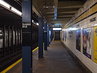
The Sutphin Boulevard–Archer Avenue–JFK Airport station is a two-level station on the IND and BMT Archer Avenue Lines of the New York City Subway. It is located at the intersection of Sutphin Boulevard and Archer Avenue in Jamaica, Queens. It is served by the E and J trains at all times, as well as the Z train during rush hours in the peak direction. This station has four tracks and two island platforms, with two platform levels: E trains stop on the upper level while J/Z trains stop on the lower level.

<span class="mw-page-title-main">Sutphin Boulevard station (IND Queens Boulevard Line)</span> New York City Subway station in Queens

The Sutphin Boulevard station is a local station on the IND Queens Boulevard Line of the New York City Subway. Located at Sutphin Boulevard and Hillside Avenue in Jamaica, Queens, it is served by the F train at all times, the <F> train during rush hours in the reverse peak direction, and a few rush-hour E trains to Jamaica–179th Street during p.m. rush hours.

<span class="mw-page-title-main">Queens Surface Corporation</span> Defunct bus company in New York City

Queens Surface Corporation was a bus company in New York City, United States, operating local service in Queens and the Bronx and express service between Queens and Manhattan until February 27, 2005, when the MTA Bus Company took over the operations. The company was known for its orange paint scheme, used since the company's inception in the late 1930s.

<span class="mw-page-title-main">B15 (New York City bus)</span> Bus route in Brooklyn, New York

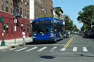
The Sumner Avenue Line and New Lots Avenue Line were two streetcar lines in Brooklyn, New York City, running mainly along Marcus Garvey Boulevard, East 98th Street, and New Lots Avenue between northern Bedford–Stuyvesant and New Lots. Originally streetcar lines, the two lines were combined as a bus route in 1947. That bus route became the present B15 Marcus Garvey Boulevard / New Lots Avenue service, operated by MTA New York City Bus' East New York Depot in East New York. The B15 continues east from New Lots to John F. Kennedy International Airport in Queens.

<span class="mw-page-title-main">Q6 (New York City bus)</span> Bus route in Queens, New York

The Q6 constitutes a bus route between Jamaica, Queens, and John F. Kennedy International Airport in Queens, New York City. Originally operated by Green Bus Lines, it is now operated by the MTA Bus Company. It does not serve the terminals at JFK Airport. Limited-stop service, which began in 2010, operates in the peak direction during rush hours.

<span class="mw-page-title-main">Select Bus Service</span> Bus service in New York City

Select Bus Service is a brand used by the Metropolitan Transportation Authority (MTA)'s Regional Bus Operations for limited-stop bus routes with some bus rapid transit features in New York City. The first SBS route was implemented in 2008 to improve speed and reliability on long, busy corridors.

<span class="mw-page-title-main">Q3 (New York City bus)</span> Bus route in Queens, New York

The Q3 bus route constitutes a public transit line in Queens, New York City, operating via Farmers Boulevard between the 165th Street Bus Terminal in Jamaica and John F. Kennedy International Airport.

The Manhattan and Queens Traction Company, also known as the Manhattan and Queens Transit Company, was a streetcar company operating in Manhattan and Queens County, New York between 1913 and 1937.

<span class="mw-page-title-main">Q58 (New York City bus)</span> Bus route in Queens, New York

The Q58 and Q58 Limited are bus routes that constitute a public transit line operating primarily in Queens, New York City, with its southern terminal on the border with Brooklyn. The Q58 is operated by the MTA New York City Transit Authority. Its precursor was a streetcar line that began operation in November 1899. and was known variously as the Flushing–Ridgewood Line, the Corona Avenue Line, and the Fresh Pond Road Line. The route became a bus line in 1949.

<span class="mw-page-title-main">Q111, Q113, and Q114 buses</span> Bus routes in Queens, New York

The Q111, Q113, and Q114 bus routes constitute a public transit line between the Jamaica and Far Rockaway neighborhoods of Queens, New York City, running primarily along Guy R. Brewer Boulevard. The Q113 and Q114 provide limited-stop service between Jamaica and Far Rockaway, connecting two major bus-subway hubs, and crossing into Nassau County. The Q111 provides local service exclusively within Queens, with the exception of select rush-hour trips to or from Cedarhurst in Nassau County. Some of the last bus routes to be privately operated in the city, they are currently operated by the MTA Bus Company brand of MTA Regional Bus Operations. The Q113 and Q114 are one of the few public transit options between the Rockaway peninsula and "mainland" New York City.

<span class="mw-page-title-main">Q72 (New York City bus)</span> Bus route in Queens, New York

The Q72 bus route constitutes a public transit route along Junction Boulevard and 94th Street in Queens, New York City. It operates between the Rego Park and East Elmhurst neighborhoods of Queens, and extends into LaGuardia Airport at the north end of the borough. It is city-operated under the MTA Bus Company brand of MTA Regional Bus Operations.

<span class="mw-page-title-main">Woodhaven and Cross Bay Boulevards buses</span> Bus routes in Queens, New York

The Q11, Q21, Q52, and Q53 bus routes constitute a public transit corridor running along Woodhaven and Cross Bay Boulevards in Queens, New York City. The corridor extends primarily along the length of the two boulevards through "mainland" Queens, a distance of 6 miles (9.7 km) between Elmhurst and the Jamaica Bay shore in Howard Beach. The Q52 and Q53 buses, which provide Select Bus Service along the corridor, continue south across Jamaica Bay to the Rockaway peninsula, one of the few public transit options between the peninsula and the rest of the city.

<span class="mw-page-title-main">Q65 (New York City bus)</span> Bus route in Queens, New York

The Q65 bus route constitutes a public transit line in Queens, New York City. The south-to-north route runs primarily on 164th Street, operating between two major bus-subway hubs: Sutphin Boulevard–Archer Avenue station in Jamaica and Flushing–Main Street station in Flushing. It then extends north along College Point Boulevard to College Point at the north end of the borough. The route is city-operated under the MTA Bus Company brand of MTA Regional Bus Operations.

<span class="mw-page-title-main">Q25 and Q34 buses</span> Bus routes in Queens, New York City

The Q25 and Q34 bus routes constitute a public transit line in Queens, New York City. The south-to-north route runs primarily on Parsons Boulevard and Kissena Boulevard, serving two major bus-subway hubs: Sutphin Boulevard–Archer Avenue–Jamaica and Flushing–Main Street. The Q25 terminates in College Point, and the Q34 in Whitestone, both in northern Queens.

<span class="mw-page-title-main">Q20 and Q44 buses</span> Bus routes in Queens and the Bronx, New York

The Q20A and Q20B and Q44 bus routes constitute the Main Street Line, a public transit line in Queens, New York City, running primarily along Main Street between two major bus-subway hubs in the neighborhoods of Jamaica and Flushing. The Q20A/B terminates in College Point at the north end of Queens. The Q44 continues north into the borough of the Bronx, terminating in the West Farms neighborhood near the Bronx Zoo. The Q44 is one of two Queens bus routes to operate between the two boroughs.

<span class="mw-page-title-main">Q64, QM4 and QM44 buses</span> Bus routes in Queens, New York

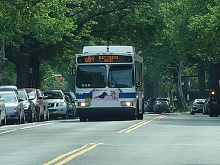
The Q64, QM4 and QM44 bus routes constitute a public transit line in Queens, New York City. The east-to-west Q64 route runs primarily on Jewel Avenue operating between the Forest Hills–71st Avenue subway station in Forest Hills and 164th Street in Electchester. The QM4 route is an express bus route running from Midtown Manhattan to Electchester running via Sixth Avenue in Manhattan and Jewel Avenue in Queens. The QM44 route is an express bus route running from Midtown Manhattan to Electchester via Third Avenue in Manhattan and Jewel Avenue in Queens.

<span class="mw-page-title-main">Q55 (New York City bus)</span> Bus route in Queens, New York

The Richmond Hill Line is a surface transit line on Myrtle Avenue in Queens, New York City. Once a streetcar line owned by the Brooklyn–Manhattan Transit Corporation, it was replaced on April 26, 1950 by the B55 bus route. The trolley tracks were not removed until April 1955, when Myrtle Avenue was being repaved. The bus was renumbered on December 11, 1988 as the Q55 Myrtle Avenue (East) bus route (as opposed to the B54 route on the western portion of Myrtle Avenue), operated by the New York City Transit Authority.

<span class="mw-page-title-main">Union Turnpike express buses</span> Express bus routes in Queens and Manhattan, New York

The QM1, QM5, QM6, QM7, QM8, QM31, QM35, and QM36 bus routes constitute a public transit line in New York City, operating express between Northeast Queens and Midtown or Downtown Manhattan. The routes operate primarily on Union Turnpike in Queens, and travel non-stop via Queens Boulevard, the Long Island Expressway, and the Midtown Tunnel or Queensboro Bridge between Queens and Manhattan.

<span class="mw-page-title-main">Hillside Avenue buses</span> Bus routes in Queens, New York

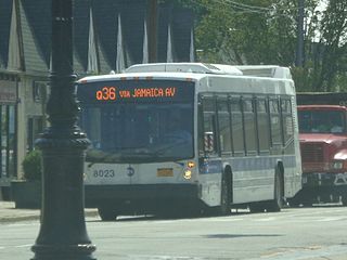
The Q1, Q36, and Q43 bus routes constitute a public transit line in Queens, New York City. The routes run primarily along Hillside Avenue from the Jamaica, Queens commercial and transportation hub towards several eastern Queens neighborhoods on the city border with Nassau County. Originally operated by the North Shore Bus Company until 1947, all three routes are now operated by MTA Regional Bus Operations under the New York City Transit brand.

References

  1. 1 2 3 4 5 6 7 8 9 10 Seyfried, Vincent F. (1950). "Full text of "New York and Queens County Railway and the Steinway Lines, 1867-1939."". archive.org . Vincent F. Seyfried . Retrieved December 20, 2015.
  2. 1 2 MTA Regional Bus Operations. "Q60 bus schedule".
  3. "Subway and bus ridership for 2023". mta.info. April 29, 2024. Retrieved May 2, 2024.
  4. 1 2 3 4 5 6 "Several Queens Trolley Lines Quit 70 Years Ago". New York Division Bulletin. 50 (10). Electric Railroaders Association: 1, 4. October 2007. Retrieved January 1, 2016.
  5. 1 2 Broderick, Lee (February 4, 1936). "Bus Must Use Trolley Route, Jamaican Say". Brooklyn Daily Eagle . p. 6. Retrieved January 2, 2016 via Newspapers.com.
  6. 1 2 3 "Install Shuttle Service: Better Trolley Facilities Assured for Jamaica Section" (PDF). The New York Times . April 30, 1916. Retrieved January 2, 2016.
  7. Roger P. Roess; Gene Sansone (August 23, 2012). The Wheels That Drove New York: A History of the New York City Transit System. Springer Science & Business Media. p. 81. ISBN   978-3-642-30484-2.
  8. 1 2 3 4 5 6 "Queensborough Bridge Centennial". New York Division Bulletin. 52 (3). Electric Railroaders Association: 1–5. March 2009. Retrieved January 1, 2016.
  9. Kerson, Paul E. (August 15, 1994). "Planned Airport Rail Can Use Little-Known East Side Terminal". The New York Times . Retrieved January 2, 2016.
  10. "Queensboro Bridge Rehabilitation Program". New York City Department of Transportation. Archived from the original on March 30, 2008. Retrieved March 13, 2010.
  11. "Queens Bus Map" (PDF). Metropolitan Transportation Authority. August 2022. Retrieved September 29, 2022.
  12. 1 2 "Analysis of Routes and Ridership of a Franchise Bus Service: Green Bus Lines" (PDF). utrc2.org/ . City College of New York. October 2000. Retrieved September 30, 2015.
  13. 1 2 Urbitran Associates, Inc (May 2004). "NYCDOT Bus Ridership Survey and Route Analysis Final Report: Chapter 4 Operating and Financial Performance" (PDF). nyc.gov . New York City Department of Transportation . Retrieved December 20, 2015.
  14. "Appendix B: Route Profiles" (PDF). nyc.gov . New York City Department of Transportation . Retrieved November 8, 2015.
  15. 1 2 "Buses to Replace Queens Blvd. Cars Within Six Weeks: Traction Co. Pays City $318,000 on Old Tax in City Hall Ceremony". Brooklyn Daily Eagle . December 13, 1936. p. 19. Retrieved January 2, 2016 via Newspapers.com.
  16. 1 2 3 4 "Queens Boulevard To Get A Bus Line: Mayor Surprises Harvey With Agreement for Early Removal of Disputed Car Tracks" (PDF). The New York Times . October 6, 1935. Retrieved January 3, 2016.
  17. 1 2 3 "New Queens Trolley Road: One Section of New Line to Jamaica Opened" (PDF). The New York Times . February 2, 1913. Retrieved January 3, 2016.
  18. Sparberg, Andrew J. (October 1, 2014). From a Nickel to a Token: The Journey from Board of Transportation to MTA. Fordham University Press. ISBN   978-0-8232-6190-1.
  19. Seyfried, Vincent F. (1961). "Full text of "Story of the Long Island Electric Railway and the Jamaica Central Railways, 1894-1933 /"". archive.org . F. E. Reifschneider. Retrieved December 20, 2015.
  20. 1 2 "Hylan Jitney Bus In Elmhurst Crash Overturns; 27 Hurt: Locked Wheels With Touring Car in queens Boulevard Jam. Both Cars Wrecked". Brooklyn Daily Eagle . August 30, 1920. Retrieved January 2, 2016 via Newspapers.com.
  21. "City Bus Line for Jamaica: Service to Manhattan Starts Today Along Suspended Trolley Routes" (PDF). The New York Times . August 16, 1920. Retrieved January 4, 2016.
  22. "5-Cent Ride Extended: New Fare Point Fixed on Manhattan & Queens Trolley System" (PDF). The New York Times . November 1, 1923. Retrieved January 3, 2016.
  23. "Deadlock Delays Queens BoulevarD: Removal of Trolley Tracks Leads to a Controversy Which Prevents Improvement" (PDF). The New York Times . July 19, 1924. Retrieved January 3, 2016.
  24. "Work On Queens Road Soon: Contractors to Get Order to Move Tracks on Boulevard" (PDF). The New York Times . March 9, 1927. Retrieved January 3, 2016.
  25. "Opposes Bus Line Plan: Traction Company to Fight Queens Boulevard Project" (PDF). The New York Times . July 31, 1925. Retrieved January 3, 2016.
  26. "Action Is Put Off On Buses In Queens: Delaney Board Favors Delay in Granting Franchises for Boulevard Line" (PDF). The New York Times . June 10, 1927. Retrieved January 3, 2016.
  27. "Plan To Get Bus Line On Queens Boulevard: Civic Workers in Move to Supplement Trolley Service or Scrap It" (PDF). The New York Times . July 18, 1926. Retrieved January 3, 2016.
  28. "Queens Blvd. Bus Plan Meets Favor: Civic Groups Approve Move to End Trolleys". Brooklyn Daily Eagle . April 17, 1927. p. 18. Retrieved January 2, 2016 via Newspapers.com.
  29. "Mayor Signs Grant Dooming Car Line: Approves Franchise for buses to Queens Upon Payment of $318,000 Back Taxes" (PDF). The New York Times . December 13, 1936. Retrieved January 3, 2016.
  30. "Franchise Hearing: Motor Omnibus Lines, Queens" (PDF). Long Island Daily Press. Fultonhistory.com. December 4, 1936. p. 28. Retrieved January 9, 2016.
  31. "To Welcome Queens Bus Line" (PDF). The New York Times . April 14, 1937. Retrieved January 3, 2016.
  32. "Green Bus Lines, Inc., Triboro Coach Corporation, Jamaica Central Railways, Inc". sec.gov . GTJ Reit, Inc. February 9, 2007. Retrieved January 2, 2016.
  33. Campanile, Carl (June 15, 1999). "TA'S IN ORBIT OVER ITS NEW BUS-TRACKER SYSTEM". New York Post . Retrieved December 17, 2015.
  34. Topousis, Tom (November 15, 2000). "CITY'S DOT TO TRAIN EYE IN SKY ON BUSES". New York Post . Retrieved December 17, 2015.
  35. Silverman, Norman (July 26, 2010). "The Merger of 7 Private Bus Companies into MTA Bus" (PDF). apta.com . American Public Transportation Association, Metropolitan Transportation Authority. Archived from the original (PDF) on October 16, 2015. Retrieved October 16, 2015.
  36. Lueck, Thomas J. (April 23, 2005). "City to Buy Private Bus Company for Service in Three Boroughs". The New York Times . Retrieved October 13, 2015.
  37. "Mayor Bloomberg Announces MTA Takeover of Green Bus Lines". The official website of the City of New York. January 8, 2006. Retrieved December 31, 2015.
  38. "Q60 Bus Schedule: Effective Summer 2007" (PDF). mta.info . MTA Bus Company. 2007. Archived from the original (PDF) on September 29, 2007. Retrieved January 2, 2016.
  39. "MTA Bus Service Changes". Metropolitan Transportation Authority. December 2008. Archived from the original on December 24, 2008. Retrieved January 1, 2016.
  40. Goldman, Sam (November 20, 2008). "MTA Takes Over 20 Stops Away From Q60 Bus Route: Boards 2 And 6 Caught Off-Guard". Times Newsweekly. Retrieved January 2, 2016.
  41. Goldman, Sam (December 18, 2008). "MTA Bus Co. VP Defends Q60 Changes: Claims Service, Reliability Will Improve". Times Newsweekly. Retrieved January 2, 2016.
  42. "mta.info | Planned Service Changes". April 27, 2010. Archived from the original on April 27, 2010. Retrieved January 1, 2016.
  43. "Planned Service Changes". mta.info. Metropolitan Transportation Authority. 2012. Archived from the original on August 29, 2012. Retrieved June 28, 2019.
  44. Acevedo, Angélica (December 17, 2019). "MTA gives 'sneak peek' of transformative Queens bus network redesign plan". QNS.com. Retrieved January 1, 2020.
  45. "MTA Unveils Draft Proposal to Redesign Bus Network in Queens". Spectrum News NY1 | New York City. December 31, 2019. Retrieved January 1, 2020.
  46. "Draft Plan, Queens Bus Network Redesign". Metropolitan Transportation Authority. December 2019. Retrieved January 1, 2020.
  47. "Queens bus network redesign remains on hold amid COVID-19 pandemic: MTA". QNS.com. Archived from the original on July 5, 2020. Retrieved July 5, 2020.
  48. Duggan, Kevin (December 15, 2021). "MTA to release 'totally redone' Queens bus network redesign draft in early 2022". amNewYork. Retrieved January 21, 2022.
  49. Duggan, Kevin (March 29, 2022). "FIRST ON amNY: MTA reveals new Queens bus redesign draft plan". amNewYork. Retrieved March 29, 2022.
  50. "Draft Plan, Queens Bus Network Redesign". Metropolitan Transportation Authority. March 2022. Retrieved January 1, 2020.
  51. Brachfeld, Ben (December 12, 2023). "MTA unveils final proposal for Queens bus network redesign". amNewYork. Retrieved December 13, 2023.
  52. Shkurhan, Iryna (December 13, 2023). "MTA unveils final plan to overhaul Queens bus network for the first time in decades". QNS.com. Retrieved December 14, 2023.
  53. "Final Plan, Queens Bus Network Redesign". Metropolitan Transportation Authority. December 2023. Retrieved January 1, 2020.
Template:Attached KML/Q60 (New York City bus)
KML is not from Wikidata