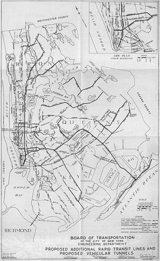
Since the opening of the original New York City Subway line in 1904, and throughout the subway's history, various official and planning agencies have proposed numerous extensions to the subway system. The first major expansion of the subway system was the Dual Contracts, a set of agreements between the City of New York and the IRT and the BRT. The system was expanded into the outer reaches of the Bronx, Brooklyn, and Queens, and it provided for the construction of important lines in Manhattan. This one expansion of the system provided for a majority of today's system.

The J Nassau Street Local and Z Nassau Street Express are two rapid transit services in the B Division of the New York City Subway. Their route emblems, or "bullets", are colored brown since they use the BMT Nassau Street Line in Lower Manhattan.

Atlantic Avenue is a major thoroughfare in the New York City boroughs of Brooklyn and Queens. It stretches from the Brooklyn waterfront on the East River all the way to Jamaica, Queens. Atlantic Avenue runs parallel to Fulton Street for much of its course through Brooklyn, where it serves as a border between the neighborhoods of Prospect Heights and Fort Greene and between Bedford-Stuyvesant and Crown Heights, and between Brooklyn Heights and Cobble Hill. This stretch of avenue is known for having a high rate of pedestrian fatalities and has been described as "the killing fields of the city."
The BMT Canarsie Line is a rapid transit line of the B Division of the New York City Subway system, named after its terminus in the Canarsie neighborhood of Brooklyn. It is served by the L train at all times, which is shown in medium gray on the New York City Subway map and on station signs.
The Myrtle Avenue Line, also called the Myrtle Avenue Elevated, is a fully elevated line of the New York City Subway as part of the BMT division. The line is the last surviving remnant of one of the original Brooklyn elevated railroads. The remnant line operates as a spur branch from the Jamaica Line to Bushwick, Ridgewood, and Middle Village, terminating at its original eastern terminal across the street from Lutheran Cemetery. Until 1969, the line continued west into Downtown Brooklyn and, until 1944, over the Brooklyn Bridge to the Park Row Terminal in Manhattan.
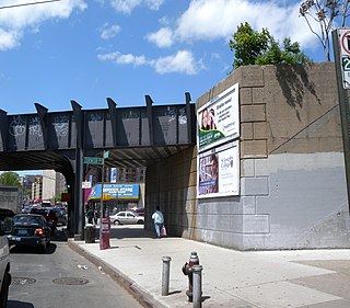
The Halsey Street station is a station on the BMT Canarsie Line of the New York City Subway. Located on the border of Ridgewood, Queens, and Bushwick, Brooklyn, at the intersection of Halsey Street and Wyckoff Avenue, it is served by the L train at all times.

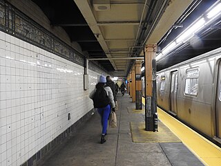
The Myrtle–Wyckoff Avenues station is a New York City Subway station complex formed by the intersecting stations of the BMT Canarsie Line and the BMT Myrtle Avenue Line, served by the L and M trains at all times. It is located at Myrtle Avenue and Wyckoff Avenue in the Bushwick neighborhood of Brooklyn and the Ridgewood neighborhood of Queens. The complex is connected by a set of stairs and several elevators and escalators between the elevated and underground levels. The station was renovated completely from 2004 to 2008.

The Woodhaven Boulevard station is a local station on the IND Queens Boulevard Line of the New York City Subway, consisting of four tracks. Located in Elmhurst, Queens, it is served by the M train on weekdays, the R train at all times except nights, and the E and F trains at night. The station serves the adjacent Queens Center Mall, as well as numerous bus lines.

The Grand Avenue–Newtown station is a local station on the IND Queens Boulevard Line of the New York City Subway. Located under private property at the northeast corner of the intersection of Grand Avenue, Broadway, and Queens Boulevard in the neighborhood of Elmhurst, Queens, it is served by the M train on weekdays, the R train at all times except nights, and the E and F trains at night.
Woodhaven Boulevard and Cross Bay Boulevard are two parts of a major boulevard in the New York City borough of Queens. Woodhaven Boulevard runs roughly north–south in the central portion of Queens. South of Liberty Avenue, it is known as Cross Bay Boulevard, which is the main north–south road in Howard Beach. Cross Bay Boulevard is locally known as simply "Cross Bay", and Woodhaven Boulevard, "Woodhaven". The completion of the boulevard in 1923, together with the construction of the associated bridges over Jamaica Bay, created the first direct roadway connection to the burgeoning Atlantic Ocean beachfront communities of the Rockaway Peninsula from Brooklyn and most of Queens.

The Grand Street Line is a public transit line in Brooklyn and Queens, New York City, running mostly along the continuous Grand Street and Grand Avenue between Williamsburg, Brooklyn and Maspeth, Queens. It then continues down Queens Boulevard to the 63rd Drive–Rego Park station. Originally a streetcar line, it is now the Q59 bus route, operated by the New York City Transit Authority between Williamsburg and Rego Park, Queens.
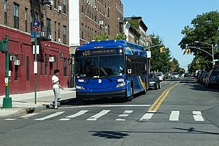
The Sumner Avenue Line and New Lots Avenue Line were two streetcar lines in Brooklyn, New York City, running mainly along Marcus Garvey Boulevard, East 98th Street, and New Lots Avenue between northern Bedford–Stuyvesant and New Lots. Originally streetcar lines, the two lines were combined as a bus route in 1947. That bus route became the present B15 Marcus Garvey Boulevard / New Lots Avenue service, operated by MTA New York City Bus' East New York Depot in East New York. The B15 continues east from New Lots to John F. Kennedy International Airport in Queens.

The Crosstown Line is a public transit line in Brooklyn, New York City, running along Van Brunt Street and Manhattan Avenue between Red Hook and Long Island City, Queens. Originally a streetcar line, it is now the B61 and the B62 bus routes. The northern section, the B62, is operated by MTA New York City Bus' Grand Avenue Depot in Maspeth, Queens, and the southern section is the B61, operated by MTA New York City Bus' Jackie Gleason Depot in Sunset Park. The entire route was a single line, the B61, until January 3, 2010; the B62 was previously a separate, parallel route between Downtown Brooklyn and Greenpoint, now part of the B43 route. The streetcar line, B61 and the original B62 previously operated from the now-closed Crosstown Depot in Greenpoint.

The B47 is a surface transit line on Ralph Avenue in Brooklyn, New York City. Once a streetcar line, it is now part of the B47 bus route, operated by the New York City Transit Authority, Prior to 1995, it was the B78 route; the northern part of the route from St. Johns Place to Woodhull Hospital was part of the B40 line. The B47 was created as a result of a merger of the B40 and B78 on September 8, 2002.

Flushing Avenue is a street running through northern Brooklyn and western Queens, beginning at Nassau Street in Fort Greene, Brooklyn, and ending at Grand Avenue in Maspeth. It divides the neighborhood of Williamsburg from Clinton Hill and East Williamsburg from Bushwick. After crossing the Queens border, the avenue serves as the dividing line between Ridgewood, Queens and West Maspeth. Flushing Avenue then terminates in Maspeth. Despite its name, however, the avenue does not extend to Flushing.

Astoria Boulevard is an important east–west commercial street in Astoria and East Elmhurst, Queens, New York City. It runs from 1st Street at the East River to the World's Fair Marina on Flushing Bay, where it merges with Northern Boulevard. Just before the junction of the two boulevards, there is a large two lane ramp leading to the Whitestone Expressway. Most of the traffic on Astoria Boulevard heads toward this ramp, and then onto the Expressway.
The Elmhurst station was a station of the Port Washington Branch of the Long Island Rail Road. It was located on Broadway between Cornish and Whitney Avenues in the Elmhurst section of Queens, New York City. In 2014, the Metropolitan Transportation Authority (MTA) had proposed to rebuild the station. As of 2023, only a preliminary design study is funded, with construction being considered for a future MTA capital program.

Broadway is an avenue in the New York City borough of Brooklyn that extends from the East River in the neighborhood of Williamsburg in a southeasterly direction to East New York for a length of 4.32 miles (6.95 km). It was named for the Broadway in Manhattan. The East New York terminus is a complicated intersection with East New York Avenue, Fulton Street, Jamaica Avenue, and Alabama Avenue. The BMT Jamaica Line of the New York City Subway runs on elevated tracks over Broadway from the Williamsburg Bridge to East New York on its way to Queens. Broadway forms the boundary between the neighborhoods of Bushwick, which lies above Broadway to the northeast, and Bedford–Stuyvesant, which is to the southwest.

The Q60 bus route constitutes a public transit line running primarily along Queens Boulevard in Queens, New York City, extending from Jamaica, Queens, to Midtown Manhattan via Queens Boulevard and the Queensboro Bridge. It is city-operated under the MTA Bus Company brand of MTA Regional Bus Operations.

The Q58 and Q58 Limited are bus routes that constitute a public transit line operating primarily in Queens, New York City, with its southern terminal on the border with Brooklyn. The Q58 is operated by the MTA New York City Transit Authority. Its precursor was a streetcar line that began operation in November 1899. and was known variously as the Flushing–Ridgewood Line, the Corona Avenue Line, and the Fresh Pond Road Line. The route became a bus line in 1949.