
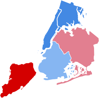
Queens is a borough of New York City, coextensive with Queens County, in the U.S. state of New York. Located near the western end of Long Island, it is the largest of the five New York City boroughs by area. It is bordered by the borough of Brooklyn and by Nassau County to its east, and shares maritime borders with the boroughs of Manhattan, the Bronx, and Staten Island, as well as with New Jersey. Queens is the most linguistically and ethnically diverse place in the world.

Long Island City (LIC) is a neighborhood within the New York City borough of Queens. It is bordered by Astoria to the north; the East River to the west; Sunnyside to the east; and Newtown Creek, which separates Queens from Greenpoint, Brooklyn, to the south. Its name refers to its location on the western tip of Long Island.

The Queensboro Bridge, officially the Ed Koch Queensboro Bridge, is a cantilever bridge over the East River in New York City. Completed in 1909, it connects the Long Island City neighborhood in the borough of Queens with the East Midtown and Upper East Side neighborhoods in Manhattan, passing over Roosevelt Island. Because the western end of the bridge connects to 59th Street in Manhattan, it is also called the 59th Street Bridge. The bridge consists of five steel spans measuring 3,725 ft (1,135 m) long; including approaches, its total length is 7,449 ft (2,270 m).
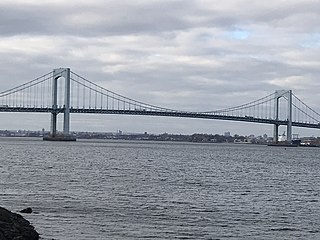
The Throgs Neck Bridge is a suspension bridge in New York City, carrying six lanes of Interstate 295 (I-295) over the East River where it meets the Long Island Sound. The bridge connects the Throggs Neck section of the Bronx with the Bay Terrace section of Queens.

The Robert F. Kennedy Bridge is a complex of bridges and elevated expressway viaducts in New York City. The bridges link the boroughs of Manhattan, Queens, and the Bronx. The viaducts cross Randalls and Wards Islands, previously two islands and now joined by landfill.
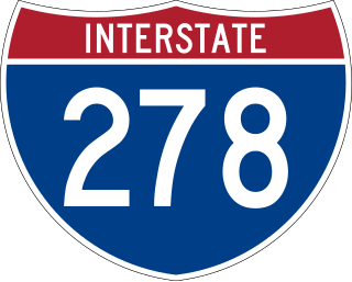
Interstate 278 (I-278) is an auxiliary Interstate Highway in New Jersey and New York in the United States. The road runs 35.62 miles (57.32 km) from US Route 1/9 (US 1/9) in Linden, New Jersey, northeast to the Bruckner Interchange in the New York City borough of the Bronx. The majority of I-278 is in New York City, where it serves as a partial beltway and passes through all five of the city's boroughs. I-278 follows several freeways, including the Union Freeway in Union County, New Jersey; the Staten Island Expressway (SIE) across Staten Island; the Gowanus Expressway in southern Brooklyn; the Brooklyn–Queens Expressway (BQE) across Northern Brooklyn and Queens; a small part of the Grand Central Parkway in Queens; and a part of the Bruckner Expressway in the Bronx. I-278 also crosses multiple bridges, including the Goethals, Verrazzano-Narrows, Kosciuszko, and Robert F. Kennedy bridges.
The Triborough Bridge and Tunnel Authority (TBTA), doing business as MTA Bridges and Tunnels, is an affiliate agency of the Metropolitan Transportation Authority that operates seven toll bridges and two tunnels in New York City. The TBTA is the largest bridge and tunnel toll agency in the United States by traffic volume. It generated more than $2.4 billion in toll revenue from 335 million vehicles in 2023. As of 2023, its operating budget was $596 million; the budget is funded through taxes and fees.

The Belt Parkway is the name given to a series of controlled-access parkways that form a belt-like circle around the New York City boroughs of Brooklyn and Queens. The Belt Parkway comprises three of the four parkways in what is known as the Belt System: the Shore Parkway, the Southern Parkway, and the Laurelton Parkway. The three parkways in the Belt Parkway are a combined 25.29 miles (40.70 km) in length. The Cross Island Parkway makes up the fourth parkway in the system, but is signed separately.

Rikers Island is a 413-acre (167.14-hectare) prison island in the East River in the Bronx that contains New York City's largest jail.

Broad Channel is a neighborhood in the southern portion of the New York City borough of Queens. It occupies the southern portion of Rulers Bar Hassock, the only inhabited island in Jamaica Bay.

Woodside is a neighborhood in the western portion of the borough of Queens in New York City. It is bordered on the south by Maspeth, on the north by Astoria, on the west by Sunnyside, and on the east by Elmhurst, Jackson Heights, and East Elmhurst. Some areas are widely residential and very quiet, while other parts, especially the ones around Roosevelt Avenue, are busier.
The Queens Community Board 1 is a local advisory group in New York City, encompassing the neighborhoods of Astoria, Long Island City, Queensbridge, Ditmars, Ravenswood, Steinway, Garden Bay, and Woodside, in the Borough of Queens. It also includes Rikers Island, the citywide correctional complex, which is within the Borough of the Bronx but connected by its only bridge to Astoria. The Board's district is delimited by the East River on both west and north, by the Brooklyn–Queens Expressway on the east, and by Northern Boulevard, the Long Island Rail Road and Bridge Plaza North on the south.

Kissena Park is a 235-acre (95 ha) park located in the neighborhood of Flushing in Queens, New York City. It is located along the subterranean Kissena Creek, which flows into the Flushing River. It is bordered on the west by Kissena Boulevard; on the north by Rose, Oak, Underhill, and Lithonia Avenues; on the east by Fresh Meadow Lane; and on the south by Booth Memorial Avenue. The park contains the city's only remaining velodrome, a lake of the same name, two war memorials, and various playgrounds and sports fields.
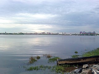
Flushing Bay is a tidal embayment in New York City. It is located on the south side of the East River and stretches to the south near the neighborhood of Flushing, Queens. It is bordered on the west by LaGuardia Airport and the Grand Central Parkway, on the south by Northern Boulevard, and on the east by the neighborhood of College Point. The Flushing River empties into the bay at its southeast corner. A 150-foot-wide navigational channel (46 m) dredged at a depth of 14 feet (4.3 m) runs along much of the bay's length.

The Vernon C. Bain Correctional Center was an 800-bed jail barge used to hold inmates for the New York City Department of Corrections. The barge was anchored off the Bronx's southern shore, across from Rikers Island, near Hunts Point. It was built for $161 million at Avondale Shipyard in Louisiana, along the Mississippi River near New Orleans, and brought to New York in 1992 to reduce overcrowding in the island's land-bound buildings for a lower price. Nicknamed "The Boat" by jail staff and inmates, it was designed to handle inmates from medium- to maximum-security in 16 dormitories and 100 cells.

Francis Lewis Boulevard is a boulevard in the New York City borough of Queens. The roadway is named for Francis Lewis, a Queens resident who was a signer of the United States Declaration of Independence. The boulevard zigzags across Queens by including segments of several other roadways that were renamed to become parts of the boulevard.

Bowery Bay is a bay off the East River in New York City. It is located near the Ditmars Steinway area in the neighborhood of Astoria in the New York City borough of Queens. It is bordered on the west by the Bowery Bay Water Pollution Control Plant and on the south and east by LaGuardia Airport.

The 1993 New York City mayoral election was held on Tuesday, November 2. Incumbent Mayor David Dinkins ran for re-election to a second term, but lost in a rematch with Republican Rudy Giuliani.
The 1989 New York City mayoral election was held on Tuesday, November 7.
The Q69 and Q100 Limited bus routes constitute a public transit line in western Queens, New York City. Beginning at Queens Plaza in Long Island City, the routes run primarily along 21st Street through the neighborhoods of Long Island City and Astoria. The Q69 makes all local stops, while the Q100 makes four limited stops along the shared corridor between Queens Plaza and Ditmars Boulevard. At Ditmars Boulevard, the Q69 turns east towards Jackson Heights and East Elmhurst near LaGuardia Airport. The Q100, meanwhile, continues north of Queens across Bowery Bay to the city jail complex on Rikers Island in the Bronx, providing the only public transit service to the island.


