
The 6 Lexington Avenue Local and <6> Pelham Bay Park Express are two rapid transit services in the A Division of the New York City Subway. Their route emblems, or "bullets", are colored forest green since they use the IRT Lexington Avenue Line in Manhattan. Local service is denoted by a (6) in a circular bullet, and express service is denoted by a <6> in a diamond-shaped bullet. On the R62A rolling stock, this is often indicated by LEDs around the service logo to indicate local or express service to riders. The LEDs illuminate in a green circle pattern for 6 local trains and in a red diamond pattern for <6> trains.

City Island is a neighborhood in the northeastern Bronx in New York City, located on an island of the same name approximately 1.5 miles (2.4 km) long by 0.5 miles (0.80 km) wide. City Island is located at the extreme western end of Long Island Sound, south of Pelham Bay Park, and east of Eastchester Bay.

The Hutchinson River Parkway is a north–south parkway in southern New York in the United States. It extends for 18.71 miles (30.11 km) from the massive Bruckner Interchange in the Throggs Neck section of the Bronx to the New York–Connecticut state line at Rye Brook. The parkway continues south from the Bruckner Interchange as the Whitestone Expressway (Interstate 678) and north into Greenwich, Connecticut, as the Merritt Parkway. The roadway is named for the Hutchinson River, a 10-mile-long (16 km) stream in southern Westchester County that the road follows alongside. The river, in turn, was named for English colonial religious leader Anne Hutchinson.

Pelham Bay Park is a municipal park located in the northeast corner of the New York City borough of the Bronx. It is, at 2,772 acres (1,122 ha), the largest public park in New York City. The park is more than three times the size of Manhattan's Central Park. The park is operated by the New York City Department of Parks and Recreation.
Baychester is a neighborhood geographically located in the northeast part of the Bronx, New York City. Its boundaries are East 222nd Street to the northeast, the New England Thruway (I-95) to the east, Gun Hill Road to the southwest, and Boston Road to the northwest. Eastchester Road is the primary thoroughfare through Baychester.
Pelham Gardens is a neighborhood located in the Northeast section of the Bronx, New York City. Its boundaries, starting from the north and moving clockwise are East Gun Hill Road to the north and east, Pelham Parkway to the south, and the IRT Dyre Avenue Line to the west ending at the esplanade. Eastchester Road is the primary thoroughfare through Pelham Gardens.
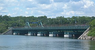
The City Island Bridge is a bridge in the New York City borough of the Bronx, connecting City Island with Rodman's Neck on the mainland. The original bridge, which carried vehicles from 1901 to 2015, was replaced by the current bridge, which opened in 2017. A temporary bridge was used for the demolition and construction period between the original and new bridges.
Allerton is a working-class neighborhood geographically located in the East Bronx section of the Bronx, New York City. It is named in honor of Daniel Allerton, an early Bronx settler who purchased and farmed this area with his wife Hustace. It consists of two subsections called Bronxwood and Laconia. Its boundaries, starting from the north and moving clockwise, are Adee Avenue, Boston Road, and Gun Hill Road to the northeast; the IRT Dyre Avenue Line to the east; Waring Avenue to the south; and Bronx River Parkway to the west. White Plains Road and Boston Road are the primary thoroughfares through Allerton.

The Pelham Islands are a group of islands in western Long Island Sound that belonged to Thomas Pell in the 17th century. The islands, and most of the surrounding area, were purchased from the Siwanoy Indians by Pell in 1654, creating Pelham Manor. This large tract of land would eventually become the present-day Town and Village of Pelham and Pelham Manor, Town of Eastchester, cities of New Rochelle and Mount Vernon in Westchester County, and the Pelham Bay and Eastchester neighborhoods of the Bronx in New York City.

Williamsbridge is a neighborhood geographically located in the north-central portion of the Bronx in New York City. Its boundaries, starting from the north and moving clockwise are East 222nd Street to the north, Boston Road to the east, East Gun Hill Road to the south, and the Bronx River to the west. White Plains Road is the primary thoroughfare through Williamsbridge.
Rodman's Neck refers to a peninsula of land in the New York City borough of the Bronx that juts out into Long Island Sound. The southern third of the peninsula is used as a firing range by the New York City Police Department; the remaining wooded section is part of Pelham Bay Park. The north side is joined to what used to be Hunters Island and Twin Island to form Orchard Beach and a parking lot.

The Hutchinson River, also known as Aqueanouncke in the Munsee language, is a 10 mile-long (16 km) freshwater stream located in the New York City borough of the Bronx and Southern Westchester County, New York, United States. It forms on the New Rochelle–Scarsdale municipal line off Brookline Road in the latter community and flows south, draining a 19.4-square-mile (50 km2) area. It continues to serve as New Rochelle's city line with Eastchester; further downstream; its lower reaches divide Mount Vernon and Pelham until it enters the Bronx and empties into Long Island Sound's Eastchester Bay.

Country Club is a residential neighborhood located in the East Bronx in New York City. The neighborhood's boundaries are Middletown Road and Watt Avenue to the north, Eastchester Bay to the east, Layton Avenue and the Throggs Neck neighborhood to the south, and the New England Thruway and Pelham Bay neighborhood to the west. Pelham Bay Park, the largest public park in New York City, is located just north of Country Club.

Eastchester is a working-class neighborhood in the northeast Bronx in New York City. Its boundaries, starting from the north and moving clockwise are the Bronx-Westchester County border to the north, the New England Thruway to the east, Baychester Avenue to the south, and the intersection of 233rd Street and Baychester Avenue to the west. Boston Road is the primary thoroughfare through Eastchester and Dyre Avenue is the main commercial street. Eastchester includes the sub-neighborhood of Edenwald.

Interstate 95 (I-95) is part of the Interstate Highway System and runs from Miami, Florida, to the Canada–United States border near Houlton, Maine. In the US state of New York, I-95 extends 23.50 miles (37.82 km) from the George Washington Bridge in New York City to the Connecticut state line at Port Chester. The George Washington Bridge carries I-95 across the Hudson River from New Jersey into New York City. There, I-95 runs across Upper Manhattan on the Trans-Manhattan Expressway for 0.81 miles (1.30 km) through Washington Heights. It continues east across the Harlem River on the Alexander Hamilton Bridge and onto the Cross Bronx Expressway. In the Bronx, I-95 leaves the Cross Bronx at the Bruckner Interchange, joining the Bruckner Expressway to its end. North of the interchange with Pelham Parkway, it then continues northeast via the New England Thruway out of New York City into Westchester County and to the Connecticut state line, where I-95 continues on the Connecticut Turnpike.

The Madison Avenue Bridge is a four-lane swing bridge crossing the Harlem River in New York City, connecting Madison Avenue in Manhattan with East 138th Street in the Bronx. It was designed by Alfred P. Boller and built in 1910, doubling the capacity of an earlier swing bridge built in 1884. The bridge is operated and maintained by the New York City Department of Transportation.
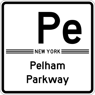
The Bronx and Pelham Parkway, also known formally as the Bronx–Pelham Parkway but called Pelham Parkway in everyday use, is a 2.25-mile-long (3.62 km) parkway in the borough of the Bronx in New York City. The road begins in Bronx Park at the Bronx River Parkway and U.S. Route 1 and ends at Interstate 95 (I-95), the New England Thruway, in Pelham Bay Park, hence the roadway's name. The parkway is designated as New York State Route 907F (NY 907F), an unsigned reference route, by the New York State Department of Transportation (NYSDOT).

New York Bus Service was a private bus company in New York City, United States. Originally a school bus company founded in the mid-1940s, it was best known for providing express bus service between Midtown Manhattan and eastern sections of the Bronx from 1970 until July 1, 2005, when the city (MTA) assumed the company's operations from longtime owner Edward Arrigoni. Former NYBS routes currently operate under the MTA Bus Company brand of the Metropolitan Transportation Authority, out of the former NYBS facility in Eastchester, Bronx.
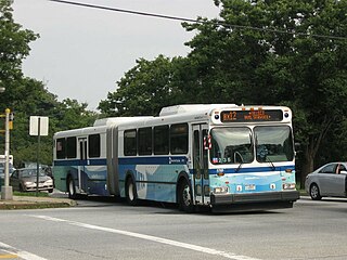
The Bx12 is a public transit line in New York City running along the 207th Street Crosstown Line, within the boroughs of Manhattan and the Bronx. The line runs along 207th Street in Upper Manhattan and along the continuous Fordham Road and Pelham Parkway in the Bronx.

The Bx23 and Q50 bus routes constitute a public transit corridor in New York City, running from the Flushing neighborhood in Queens to the Pelham Bay and Co-op City neighborhoods in the Bronx. The Bx23 provides local service in Pelham Bay and Co-op City, while the Q50 provides limited-stop service between Co-op City and subway hubs in Pelham Bay and Flushing. Both routes are city-operated under the MTA Bus Company brand of MTA Regional Bus Operations, and are the only two local routes in the Bronx to operate under the MTA Bus brand, rather than under the MaBSOTA brand that all other Bronx bus routes operate under.

