List of bridges and tunnels in New York City

Last updated

The Manhattan Bridge and Brooklyn Bridge on the East River in 1981 Manhattan and Brooklyn bridges on the East River, New York City, 1981.jpg
The Manhattan Bridge and Brooklyn Bridge on the East River in 1981

New York City is home to many bridges and tunnels. Several agencies manage this network of crossings. The New York City Department of Transportation owns and operates almost 800. [1] The Metropolitan Transportation Authority, Port Authority of New York and New Jersey, New York State Department of Transportation and Amtrak have many others.

Contents

Many of the city's major bridges and tunnels have broken or set records. Opened in 1927, the Holland Tunnel was the world's first mechanically ventilated underwater vehicular tunnel. The Brooklyn Bridge, Williamsburg Bridge, George Washington Bridge, and Verrazzano-Narrows Bridge were the world's longest suspension bridges when opened in 1883, [2] 1903, [3] 1931, [4] and 1964 [5] respectively. There are 789 bridges and tunnels in New York.

Bridges

New York City's crossings date back to 1693, when its first bridge, known as the King's Bridge, was constructed over Spuyten Duyvil Creek between Manhattan and the Bronx, located in the present-day Kingsbridge neighborhood. The bridge, composed of stone abutments and a timber deck, was demolished in 1917. The oldest crossing still standing is High Bridge, built 1848 to carry the Croton Aqueduct from Manhattan to the Bronx over the Harlem River. [6] This bridge was built to carry water to the city as part of the Croton Aqueduct system.

Ten bridges and one tunnel serving the city have been awarded some level of landmark status. The Holland Tunnel was designated a National Historic Landmark in 1993 in recognition of its pioneering role as the first mechanically ventilated vehicular underwater tunnel, operating since 1927. The George Washington, High, Hell Gate, Queensboro, Brooklyn, Manhattan, Macombs Dam, Carroll Street, University Heights, and Washington Bridges have all received landmark status, as well. [6]

New York features bridges of many lengths and types, carrying vehicular, bicycle, pedestrian, and subway traffic. The George Washington Bridge, spanning the Hudson River between New York City and Fort Lee, New Jersey, is the world's busiest bridge in terms of vehicular traffic. [7] [8] The George Washington, Verrazzano-Narrows, and Brooklyn Bridges are noted for their architecture, while others are more well known for their functional importance, such as the Williamsburg Bridge with 8 vehicular lanes, 2 subway tracks, a bike lane, and pedestrian walkways.

Bridges by body of water

East River

South Street Seaport, with the Brooklyn Bridge, Manhattan Bridge, and Williamsburg Bridge visible in the background South Street Seaport2.jpg
South Street Seaport, with the Brooklyn Bridge, Manhattan Bridge, and Williamsburg Bridge visible in the background
J train on the Williamsburg Bridge NYCSub JMZ Williamsburg 2.jpg
J train on the Williamsburg Bridge

From south to north:

NameOpening yearLengthCarriesComments
feetmeters
Brooklyn Bridge 18835,9881,8255 lanes of roadway (2 Manhattan-bound, 3 Brooklyn-bound)Oldest suspension bridge in NYC. Also oldest suspension/cable-stayed hybrid bridge.
Manhattan Bridge 19096,8542,0897 lanes of roadway and NYCS-bull-trans-B-Std.svg NYCS-bull-trans-D-Std.svg NYCS-bull-trans-N-Std.svg NYCS-bull-trans-Q-Std.svg trainsDouble-decker bridge with 5 westbound lanes and 2 eastbound lanes. 3 of the westbound lanes and the subway are below the other 4 lanes.
Williamsburg Bridge 19037,308.02,227.488 lanes of roadway (4 in each direction) and NYCS-bull-trans-J-Std.svg NYCS-bull-trans-M-Std.svg NYCS-bull-trans-Z-Std.svg trains
Queensboro Bridge 19093,7241,1359 lanes of NY-25.svg NY 25 (Queens Boulevard)Officially known as the Ed Koch Queensboro Bridge. Also known as 59th Street Bridge. Reversible 4 lanes on the upper deck, and 2 westbound/3 eastbound lanes on the lower deck.
Roosevelt Island Bridge 19552,877.0876.912 lanes of roadway (1 in each direction)East channel only
Triborough Bridge (Suspension Bridge)19362,7908508 lanes of I-278.svg I-278 (4 in each direction)Officially known as the Robert F. Kennedy Bridge
Hell Gate Bridge 19161,0203103 rail tracks (2 of Northeast Corridor, 1 of New York Connecting Railroad)
Rikers Island Bridge 19664,200.01,280.162 lanes of roadwayOnly connects Rikers Island to Queens
Bronx–Whitestone Bridge 19393,770.01,149.106 lanes of I-678.svg I-678 (Whitestone Expressway)
Throgs Neck Bridge 19612,910.0886.976 lanes of I-295.svg I-295 (Throgs Neck Expressway)

Harlem River

Wards Island Bridge in "open" position Ward's Island Bridge, New York City.JPG
Wards Island Bridge in "open" position

From south to north, east to west:

NameOpening yearLengthCarriesComments
feetmeters
Wards Island Bridge 1951937285.6Pedestrians and bicycles only
Triborough Bridge (Vertical-Lift Bridge)19367502302 lanes of exit ramp from F.D.R. Drive Officially known as the Robert F. Kennedy Bridge
Willis Avenue Bridge 19013,2129794 lanes of roadwayNorthbound traffic only
Third Avenue Bridge 18982,800.0853.445 lanes of roadwaySouthbound traffic only
Park Avenue Bridge 19563301004 tracks of Metro-North
Madison Avenue Bridge 19101,8935774 lanes of roadway
145th Street Bridge 19051,6044894 lanes of roadway
Macombs Dam Bridge 18952,5397744 lanes of roadway
High Bridge 18482,000600Pedestrian walkway and bicycle lanesOldest surviving bridge in New York City
Alexander Hamilton Bridge 19632,3757248 lanes of I-95.svg I-95 and US 1.svg US 1
Washington Bridge 18882,375723.96 lanes of roadway
University Heights Bridge 1908269822 lanes of roadway
Broadway Bridge 1962558.0170.084 lanes of Broadway/ US 9.svg US 9 and the NYCS-bull-trans-1-Std.svg trainAlso known as Harlem Ship Canal Bridge
Henry Hudson Bridge 19362,2086736 lanes of NY-9A.svgHenry Hudson Pkwy Shield free.svg NY 9A  / Henry Hudson Parkway Double-decked bridge
Spuyten Duyvil Bridge 18996101861 track of Empire Corridor Swing bridge

Hudson River

George Washington Bridge George Washington Bridge, HAER NY-129-28.jpg
George Washington Bridge
NameOpening yearLengthCarriesComments
feetmeters
George Washington Bridge 19314,760.01,450.8514 lanes of I-95.svgUS 1.svgUS 9.svgUS 46.svg I-95  / US 1  / US 9  / US 46 Double-deck, 8 lanes on upper level, 6 lanes on lower level. 7 lanes in each direction.

New York Bay

Verrazzano-Narrows Bridge NYC Verrazano-Narrows Bridge 1.jpg
Verrazzano-Narrows Bridge
NameOpening yearLengthCarriesComments
feetmeters
Verrazzano-Narrows Bridge 196413,7014,17613 lanes of I-278.svg I-278 Double-deck, 7 lanes on upper level; 3 in each direction and 1 reversible HOV 3+ lane. 6 lanes on lower level; three in each direction.

Newtown Creek

Borden Avenue, Long Island City Borden Avenue Bridge over Dutch Kills slide tracks jeh.jpg
Borden Avenue, Long Island City
NameOpening yearLengthCarriesComments
feetmeters
Kosciuszko Bridge 2017, 20196,0201,8356 lanes of I-278.svg I-278 Eastbound span opened in April 2017, and westbound span opened in August 2019. It replaces the original bridge
Pulaski Bridge 19542,8208606 lanes of McGuinness Boulevard Drawbridge
Greenpoint Avenue Bridge 1987 [9] 180554 lanes of Greenpoint Avenuea.k.a. J. J. Byrne Memorial Bridge
Drawbridge
Grand Street Bridge 1903 [9] 22769.21 lane of Grand Avenue Swing bridge; one-lane bridge
Metropolitan Avenue Bridge1933 [9] 11133.84 lanes of Grand Street and Metropolitan Avenue Drawbridge; Crosses English Kills, a tributary of Newtown Creek [9]

Other

The Bronx

NameOpening yearLengthCarriesComments
Bronx Kill
Robert F. Kennedy Bridge 19361,610 feet (490 m)8 lanes of I-278.svg I-278 Formerly known as the Triborough Bridge
Hutchinson River (heading downriver)
Eastchester Bridge19260.4 miles4 lanes of Boston Road (US 1.svg US 1)
I-95 bridge19615,280 feet6 lanes of I-95.svg I-95
Hutchinson River Parkway Bridge1941673 feet (205 m)6 lanes of Hutchinson River Pkwy Shield.svg Hutchinson River Parkway Drawbridge
Pelham Bay Bridge 190881 feet (25 m) Northeast Corridor (Amtrak)Also called Amtrak Pelham Bay Bridge
Pelham Bridge 1908892 feet (272 m)4 lanes of Shore RoadDrawbridge
Westchester Creek
Unionport Bridge1953526 feet (160.3 m)7 lanes of I-278.svgI-95.svg I-278 ( Bruckner Boulevard ) / I-95
Bronx River
Eastern Boulevard Bridge1953634 feet (193.2 m)I-278.svg I-278 Drawbridge
Eastchester Bay
City Island Bridge 1901950 feet (290 m)3 lanes of City Island Avenue

Brooklyn

Ninth Street Bridge, spanning Gowanus Canal in Brooklyn NYCS IND Culver GowanusCanalBridge.jpg
Ninth Street Bridge, spanning Gowanus Canal in Brooklyn
NameOpening yearLengthCarriesComments
Gowanus Canal
Union Street Bridge1905 [10] 600 feet2 lanes of Union StreetDrawbridge
Carroll Street Bridge 1889 [10] 300 feet2 lanes of Carroll StreetNew York City Designated Landmark and one of four retractable bridges in the country [11]
Third Street Bridge1905 [10] 350 feetThird Street
Ninth Street Bridge1999 [10] 700 feetNinth StreetVertical Lift Bridge
Culver Viaduct 1933 [12] 0.6 miles NYCS-bull-trans-F-Std.svg NYCS-bull-trans-Fd-Std.svg NYCS-bull-trans-G-Std.svg trainspasses over the Ninth Street Bridge, carrying 4 tracks, 2 express and 2 local
Hamilton Avenue Bridge1942 [10] 0.7 milesHamilton Avenuepasses under the Gowanus Expressway and carries four lanes of traffic in each direction
Gowanus Expressway 1941 [13] 9 lanes of I-278.svg I-278 (Gowanus Expressway)
Mill Basin
Mill Basin Bridge 20176 lanes of Belt Pkwy Shield free.svg Belt Parkway The bridge has a combined bicycle and pedestrian pathway on the eastbound side of the bridge which carries the Jamaica Bay Greenway
Mill Basin Drawbridge

(demolished)

1940825 ft6 lanes of Belt Pkwy Shield free.svg Belt Parkway Twin-leaf bascule bridge; demolished in 2018 and replaced by Mill Basin Bridge
Rockaway Inlet (Brooklyn and Queens)
Marine Parkway–Gil Hodges Memorial Bridge 19371226 m4 lanes of Flatbush Avenue also has a narrow combined bicycle and pedestrian path on the southbound side of the bridge

Queens

NameOpening yearLengthCarriesComments
Dutch Kills
Borden Avenue Bridge 1908 [9] 100 feet2 lanes of Borden AvenueOne of four retractable bridges in the country [11]
Hunters Point Avenue Bridge1910 [9] 500 feetHunters Point Avenue
Cabin M Bridge1 track of the Montauk Cutoff There is another abandoned track on the bridge
DB Cabin Bridge1 track of the Montauk Branch The bridge was originally built to carry three tracks
Jamaica Bay
Cross Bay Veterans Memorial Bridge 19700.7 miles6 lanes Cross Bay Boulevard
Joseph P. Addabbo Memorial Bridge 19710.7 miles6 lanes of Cross Bay Boulevard
North Channel Swing Bridge NYCS-bull-trans-A-Std.svg trainNot actually a movable bridge.
Howard Beach to Broad Channel.
Beach Channel Drawbridge NYCS-bull-trans-A-Std.svg NYCS-bull-trans-S-Std.svg trains Broad Channel to The Rockaways
102nd Street Bridge Connecting Hamilton Beach at Russell Street with Howard Beach, also known as "Lenihan's Bridge".
Hawtree Creek Bridge 163rd Avenue and 99th Street in Howard Beach across to Hamilton Beach at Rau Court and Davenport Court
Rockaway Inlet (Brooklyn and Queens)
Marine Parkway-Gil Hodges Memorial Bridge 19371226 m4 lanes of Flatbush Avenue

Staten Island

NameOpening yearLengthCarriesComments
Arthur Kill
Goethals Bridge 2018 [14] [15] 2225.04 m6 lanes of I-278.svg I-278 Replaced the old Goethals Bridge (completed 1928); the two new spans are a cable-stayed design
Arthur Kill Vertical Lift Bridge 1959170.08 m CSX and M&E rail lines
Outerbridge Crossing 19283093 m4 lanes of Ellipse sign 440.svg Route 440; NY-440.svg NY 440
Kill Van Kull
Bayonne Bridge 19311761.74 m4 lanes of NY-440.svg NY 440; Ellipse sign 440.svg Route 440 raised and rebuilt in 2019

Tunnels

The Queens-Midtown Tunnel Midtown Tunnel.JPG
The Queens–Midtown Tunnel

Each of the tunnels that run underneath the East and Hudson Rivers were marvels of engineering when first constructed. The Holland Tunnel is the oldest of the vehicular tunnels, opening to great fanfare in 1927 as the first mechanically ventilated underwater tunnel. The Queens Midtown Tunnel was opened in 1940 to relieve the congestion on the city's bridges. Each of its tubes were designed 1.5 feet (0.46 m) wider than the Holland Tunnel in order to accommodate the wider cars of the period. When the Brooklyn–Battery Tunnel opened in 1950, it was the longest continuous underwater vehicular tunnel in North America, a title it still holds. [16] The Lincoln Tunnel has three tubes linking midtown Manhattan to New Jersey, a configuration that provides the flexibility to provide four lanes in one direction during rush hours, or three lanes in both direction.

All four underwater road tunnels were built by Ole Singstad: the Holland Tunnel's original chief engineer Clifford Milburn Holland died, as did his successor, Milton H. Freeman, after which Singstad became chief engineer, finishing the Holland Tunnel and then building the remaining tunnels.

East River

PATH train emerging from the Hudson tubes, into the Exchange Place station Jersey-city-exchange-place-platform.jpg
PATH train emerging from the Hudson tubes, into the Exchange Place station
Traveling through the Holland Tunnel, from Manhattan to Jersey City, New Jersey Holland tunnel.jpg
Traveling through the Holland Tunnel, from Manhattan to Jersey City, New Jersey

From south to north:

NameOpening yearLengthCarriesComments
Brooklyn–Battery Tunnel 19502,779 m (9,117 ft)4 lanes of I-478.svg I-478 Officially known as the Hugh L. Carey Tunnel
Joralemon Street Tunnel 19082,709 m (8,888 ft) NYCS-bull-trans-4-Std.svg NYCS-bull-trans-5-Std.svg trains
Montague Street Tunnel 19202,136 m (7,009 ft) NYCS-bull-trans-N-Std.svg NYCS-bull-trans-R-Std.svg NYCS-bull-trans-W-Std.svg trains
Clark Street Tunnel 19191,800 m (5,900 ft) NYCS-bull-trans-2-Std.svg NYCS-bull-trans-3-Std.svg trains
Cranberry Street Tunnel 1933 NYCS-bull-trans-A-Std.svg NYCS-bull-trans-C-Std.svg trains
Rutgers Street Tunnel 1936 NYCS-bull-trans-F-Std.svg NYCS-bull-trans-Fd-Std.svg trains
14th Street Tunnel 1924 NYCS-bull-trans-L-Std.svg train
East River Tunnels 19101,204 m (3,949 ft)part of the New York Tunnel Extension
Amtrak and Long Island Rail Road (Northeast Corridor)
Queens–Midtown Tunnel 19401,955 m (6,414 ft)4 lanes of I-495.svg I-495 ( Long Island Expressway )
Steinway Tunnel 1915 NYCS-bull-trans-7-Std.svg NYCS-bull-trans-7d-Std.svg trains
53rd Street Tunnel 1933 NYCS-bull-trans-E-Std.svg NYCS-bull-trans-M-Std.svg trains
60th Street Tunnel 1920 NYCS-bull-trans-N-Std.svg NYCS-bull-trans-R-Std.svg NYCS-bull-trans-W-Std.svg trains
63rd Street Tunnel 1989960 m (3,140 ft)Upper level: NYCS-bull-trans-F-Std.svg NYCS-bull-trans-Fd-Std.svg train
Lower level: LIRR to Grand Central Madison
Ravenswood Tunnel 1892Electricity, natural gas, steam, and number 6 fuel oilFirst tunnel under the East River and Roosevelt Island, between Big Allis power plant in Astoria and Upper East Side [17] [18]

Harlem River

From south to north:

NameOpening yearLengthCarriesComments
Lexington Avenue Tunnel 1918391 m (1,283 ft) NYCS-bull-trans-4-Std.svg NYCS-bull-trans-5-Std.svg NYCS-bull-trans-6-Std.svg NYCS-bull-trans-6d-Std.svg trains
149th Street Tunnel 1905195 m (641 ft) NYCS-bull-trans-2-Std.svg train
Concourse Tunnel 1933 NYCS-bull-trans-B-Std.svg NYCS-bull-trans-D-Std.svg trains

Hudson River

From south to north:

NameOpening yearLengthCarriesComments
Downtown Hudson Tubes 19091,720 m (5,650 ft)Montgomery-Cortlandt Tunnels
Port Authority Trans-Hudson
Holland Tunnel 1927south tube: 2,551 m (8,371 ft)
north tube: 2,608 m (8,558 ft)
4 lanes of I-78.svg I-78 (Canal Street); Ellipse sign 139.svg Route 139 (NJ side)
Uptown Hudson Tubes 19081,700 m (5,500 ft)Hoboken-Morton Tunnels
Port Authority Trans-Hudson
North River Tunnels 19101,900 m (6,100 ft)part of New York Tunnel Extension
Amtrak and New Jersey Transit (Northeast Corridor)
Lincoln Tunnel north tube: 1945
center tube: 1937
south tube: 1957
south tube: 2,440 m (8,006 ft)
center tube: 2,504 m (8,216 ft)
north tube: 2,281 m (7,482 ft)
6 lanes of NY-495.svg NY 495 (NY side); Ellipse sign 495.svg Route 495 (NJ side)

Newtown Creek

NameOpening yearCarriesComments
Greenpoint Tube 1933 NYCS-bull-trans-G-Std.svg train

Bridges and tunnels spanning land only

Bridges and tunnels by use

The relative average number of inbound vehicles between 5 a.m. and 11 a.m. to Midtown and Lower Manhattan is:

  1. Queensboro Bridge: 31,000
  2. Lincoln Tunnel: 25,944
  3. Brooklyn Bridge: 22,241
  4. Williamsburg Bridge: 18,339
  5. Queens-Midtown Tunnel: 17,968
  6. Holland Tunnel: 16,257
  7. Brooklyn Battery Tunnel: 14,496
  8. Manhattan Bridge: 13,818

See also

Related Research Articles

<span class="mw-page-title-main">Brooklyn</span> Borough of New York City

Brooklyn is a borough of New York City. Located on the westernmost end of Long Island, it is coextensive with Kings County in the U.S. state of New York. With 2,736,074 residents as of the 2020 United States census, Kings County is the most populous of the five boroughs of New York City and the most populous county in the State of New York. The population density of Brooklyn was 37,339.9 inhabitants per square mile (14,417.0/km2) in 2022, making it the second-most-densely-populated county in the United States, behind Manhattan, and it had the ninth-highest population of any county nationwide. Were Brooklyn still an independent city, it would be the fourth most populous in the U.S. after the rest of New York City, Los Angeles, and Chicago.

<span class="mw-page-title-main">Lincoln Tunnel</span> Tunnel between New Jersey and New York

The Lincoln Tunnel is an approximately 1.5-mile-long (2.4 km) tunnel under the Hudson River, connecting Weehawken, New Jersey, to the west with Midtown Manhattan in New York City to the east. It carries New Jersey Route 495 on the New Jersey side and unsigned New York State Route 495 on the New York side. It was designed by Ole Singstad and named after Abraham Lincoln. The tunnel consists of three vehicular tubes of varying lengths, with two traffic lanes in each tube. The center tube contains reversible lanes, while the northern and southern tubes exclusively carry westbound and eastbound traffic, respectively.

<span class="mw-page-title-main">Holland Tunnel</span> Tunnel between New Jersey and New York

The Holland Tunnel is a vehicular tunnel under the Hudson River that connects Hudson Square and Lower Manhattan in New York City in the east to Jersey City, New Jersey in the west. The tunnel is operated by the Port Authority of New York and New Jersey and carries Interstate 78. The New Jersey side of the tunnel is the eastern terminus of NJ Route 139. The Holland Tunnel is one of three vehicular crossings between Manhattan and New Jersey; the two others are the Lincoln Tunnel and George Washington Bridge.

<span class="mw-page-title-main">Interstate 278</span> Interstate Highway in New Jersey and New York

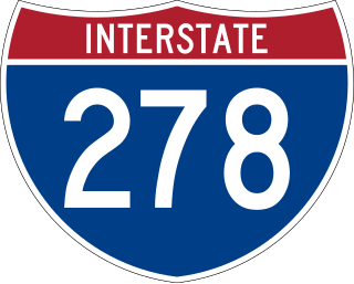
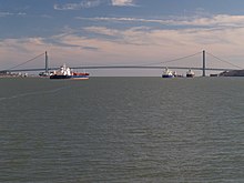
Interstate 278 (I-278) is an auxiliary Interstate Highway in New Jersey and New York in the United States. The road runs 35.62 miles (57.32 km) from US Route 1/9 (US 1/9) in Linden, New Jersey, northeast to the Bruckner Interchange in the New York City borough of the Bronx. The majority of I-278 is in New York City, where it serves as a partial beltway and passes through all five of the city's boroughs. I-278 follows several freeways, including the Union Freeway in Union County, New Jersey; the Staten Island Expressway (SIE) across Staten Island; the Gowanus Expressway in southern Brooklyn; the Brooklyn–Queens Expressway (BQE) across northern Brooklyn and Queens; a small part of the Grand Central Parkway in Queens; and a part of the Bruckner Expressway in the Bronx. I-278 also crosses multiple bridges, including the Goethals, Verrazzano-Narrows, Kosciuszko, and Robert F. Kennedy bridges.

<span class="mw-page-title-main">Proposed expansion of the New York City Subway</span>

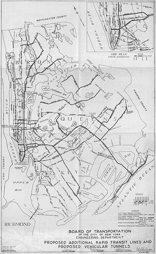
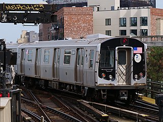
Since the opening of the original New York City Subway line in 1904, and throughout the subway's history, various official and planning agencies have proposed numerous extensions to the subway system. The first major expansion of the subway system was the Dual Contracts, a set of agreements between the City of New York and the IRT and the BRT. The system was expanded into the outer reaches of the Bronx, Brooklyn, and Queens, and it provided for the construction of important lines in Manhattan. This one expansion of the system provided for a majority of today's system.

The Brooklyn–Battery Tunnel, officially the Hugh L. Carey Tunnel and commonly referred to as the Battery Tunnel or Battery Park Tunnel, is a tolled tunnel in New York City that connects Red Hook in Brooklyn with the Battery in Manhattan. The tunnel consists of twin tubes that each carry two traffic lanes under the mouth of the East River. Although it passes just offshore of Governors Island, the tunnel does not provide vehicular access to the island. With a length of 9,117 feet (2,779 m), it is the longest continuous underwater vehicular tunnel in North America.

The Queens–Midtown Tunnel is a vehicular tunnel under the East River in New York City, connecting the boroughs of Manhattan and Queens. The tunnel consists of a pair of tubes, each carrying two lanes. The west end of the tunnel is located on the East Side of Midtown Manhattan, while the east end of the tunnel is located in Long Island City in Queens. The tunnel carries Interstate 495 (I-495) for its entire length; I-495's western terminus is at the Manhattan portal of the tunnel.

<span class="mw-page-title-main">Chrystie Street Connection</span> New York City Subway track connections

The Chrystie Street Connection is a set of New York City Subway tunnels running the length of Chrystie Street on the Lower East Side of Manhattan. It is one of the few track connections between lines of the former Brooklyn–Manhattan Transit Corporation (BMT) and Independent Subway System (IND) divisions, which together constitute the system's B Division. A major branch of the IND Sixth Avenue Line, it connects the Sixth Avenue Line to the BMT Brighton Line and BMT Fourth Avenue Line via the north side of the Manhattan Bridge and to the BMT Jamaica Line over the Williamsburg Bridge. The project, opened in 1967 and 1968, also includes the Sixth Avenue Line's Grand Street and 57th Street stations, the latter of which is not part of the connection itself.

Ole Knutsen Singstad was a Norwegian-American civil engineer best known for his work on underwater vehicular tunnels in New York City. Singstad designed the ventilation system for the Holland Tunnel, which subsequently became commonly used in other automotive tunnels, and advanced the use of the immersed tube method of underwater vehicular tunnel building, a system of constructing the tunnels with prefabricated sections.

<span class="mw-page-title-main">M (New York City Subway service)</span> New York City Subway service

The M Queens Boulevard/Sixth Avenue Local is a rapid transit service in the B Division of the New York City Subway. Its route emblem, or "bullet", is colored orange since it is a part of the IND Sixth Avenue Line in Manhattan.

<span class="mw-page-title-main">Transportation in New York City</span>

The transportation system of New York City is a network of complex infrastructural systems. New York City, being the most populous city in the United States, has a transportation system which includes one of the largest and busiest subway systems in the world; the world's first mechanically ventilated vehicular tunnel; and an aerial tramway. New York City is home to an extensive bus system in each of the five boroughs; citywide and Staten Island ferry systems; and numerous yellow taxis and boro taxis throughout the city. Private cars are less used compared to other cities in the rest of the United States.

<span class="mw-page-title-main">New York City Department of Transportation</span> New York City government agency

The New York City Department of Transportation (NYCDOT) is the agency of the government of New York City responsible for the management of much of New York City's transportation infrastructure. Ydanis Rodriguez is the Commissioner of the Department of Transportation, and was appointed by Mayor Eric Adams on January 1, 2022. Former Commissioners have included Polly Trottenberg, Janette Sadik-Khan, and Iris Weinshall. The NYCDOT has a training center in eastern Queens.

<span class="mw-page-title-main">Interstate 78 in New York</span> Highway in New York

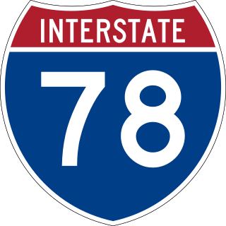
Interstate 78 (I-78) is a part of the Interstate Highway System that runs from Union Township, Lebanon County, Pennsylvania, to New York City. In the US state of New York, I-78 extends 0.5 miles (0.80 km). The entirety of I-78 consists of the Holland Tunnel, which crosses under the Hudson River from New Jersey and ends at an exit rotary in Lower Manhattan. The tunnel and its approaches are maintained by the Port Authority of New York and New Jersey (PANYNJ).

Transportation in New York is made up of some of the most extensive and one of the oldest transportation infrastructures in the country. Engineering difficulties because of the terrain of the State of New York and the unique issues of New York City brought on by urban crowding have had to be overcome since the state was young. Population expansion of the state generally followed the path of the early waterways, first the Hudson River and then the Erie Canal. Today, railroad lines and the New York State Thruway follow the same general route.

<span class="mw-page-title-main">Grand Street and Grand Avenue</span> Avenue in Brooklyn and Queens, New York

Grand Street and Grand Avenue are the respective names of a street which runs through the boroughs of Brooklyn and Queens, New York City, United States. Originating in Williamsburg, Brooklyn, Grand Street runs roughly northeast until crossing Newtown Creek into Queens, whereupon Grand Street becomes Grand Avenue, continuing through Maspeth where it is a main shopping street, until reaching its northern end at Queens Boulevard in Elmhurst.

<span class="mw-page-title-main">History of transportation in New York City</span>

Transportation in New York City has ranged from strong Dutch authority in the 17th century, expansionism during the industrial era in the 19th century and half of the 20th century, to cronyism during the Robert Moses era. The shape of New York City's transportation system changed as the city did, and the result is an expansive modern-day system of industrial-era infrastructure. New York City, being the most populous city in the United States, has a transportation system which includes one of the largest subway systems in the world; the world's first mechanically ventilated vehicular tunnel; and an aerial tramway.

<span class="mw-page-title-main">Transportation on Long Island</span> Overview of transportation on Long Island

Nearly every major type of transportation serves Long Island, including three major airports, railroads and subways, and several major highways. The New York City Subway only serves the New York City boroughs of Brooklyn and Queens. There are historic and modern bridges, recreational and commuter trails, and ferries, that connect the boroughs of Queens and Brooklyn to Manhattan, the south shore with Fire Island and Long Island's north shore and east end with the state of Connecticut.

<span class="mw-page-title-main">Staten Island Tunnel</span> Incomplete rail tunnel in New York City

The Staten Island Tunnel is an abandoned, incomplete railway and subway tunnel in Staten Island,New York City. It was intended to connect railways on Staten Island to the BMT Fourth Avenue Line of the New York City Subway, in Brooklyn, via a new crossing under the Narrows. Planned to extend 10,400 feet (3,200 m), the tunnel would have been among the world's longest at the time of its planning, in the late 19th and early 20th centuries.

<span class="mw-page-title-main">East 34th Street Ferry Landing</span> Ferry terminal in Manhattan, New York

The East 34th Street Ferry Landing provides slips to ferries and excursion boats in the Port of New York and New Jersey. It is located on the East River in New York City east of the FDR Drive just north of East 34th Street in Midtown Manhattan. The facility, owned by the city, received Federal Highway Administration funding for improvements for docking facilities and upgrading the adjacent East River Greenway in 2008. A new terminal was built and completed in 2012.

References

  1. "NYC DOT - Bridges". www1.nyc.gov. Retrieved February 20, 2022.
  2. "NYC DOT - Brooklyn Bridge" . Retrieved February 24, 2012.
  3. "NYC DOT - Williamsburg Bridge" . Retrieved February 24, 2012.
  4. "History - George Washington Bridge - The Port Authority of NY & NJ" . Retrieved February 24, 2012.
  5. "Verrazano-Narrows Bridge" . Retrieved February 24, 2012.
  6. 1 2 "NYC DOT - Frequently Asked Questions about Bridges" . Retrieved February 24, 2012.
  7. "Port Authority of New York and New Jersey - George Washington Bridge". The Port Authority of New York & New Jersey. Retrieved September 13, 2013.
  8. Bod Woodruff; Lana Zak & Stephanie Wash (November 20, 2012). "GW Bridge Painters: Dangerous Job on Top of the World's Busiest Bridge". ABC News. Retrieved September 13, 2013.
  9. 1 2 3 4 5 6 "Movable Bridges over Newtown Creek and its Tributaries". New York City. Retrieved September 20, 2013.
  10. 1 2 3 4 5 New York City Dept. of Transportation. "Bridges over the Gowanus Canal". New York City. Retrieved September 20, 2013.
  11. 1 2 Berger, Joseph (May 13, 2013). "Antique Bridge Closed to Traffic While It's Open for Repairs". New York Times. Retrieved July 1, 2018.
  12. "City Subway Extended". The New York Times. October 7, 1933. p. 16. ISSN   0362-4331 . Retrieved December 18, 2018.
  13. "Gowanus Expressway". nycroads.com. Retrieved July 1, 2018.
  14. Porpora, Tracey (June 11, 2017). "Goethals Bridge now open in both directions". SILive.com. Retrieved June 12, 2017.
  15. Grunlund, Maura (May 21, 2018). "First a.m. rush hour for new Goethals Bridge to New Jersey". SILive.com. Retrieved May 21, 2018.
  16. "Hugh L. Carey Tunnel (formerly Brooklyn-Battery Tunnel)". MTA Bridges & Tunnels. Retrieved December 2, 2015.
  17. Tunnel Under The East River
  18. How the First East River Tunnel was built